|
Heatherdale, Victoria
Heatherdale is a neighbourhood of Mitcham, in Melbourne's eastern suburbs, centred on the Heatherdale railway station, on the Lilydale and Belgrave railway lines. It is in the local government area of the City of Whitehorse The City of Whitehorse is a local government area in Victoria, Australia in the eastern suburbs of Melbourne. It has an area of and in June 2018, Whitehorse had a population of 176,196. Whitehorse was formed in December 1994 by the amalgamat .... Heatherdale junior football club existed from 1969 until 1997 when it merged with Heathmont Junior football club to become the Heathmont Jets. Localities of Melbourne City of Whitehorse {{Melbourne-geo-stub ... [...More Info...] [...Related Items...] OR: [Wikipedia] [Google] [Baidu] |
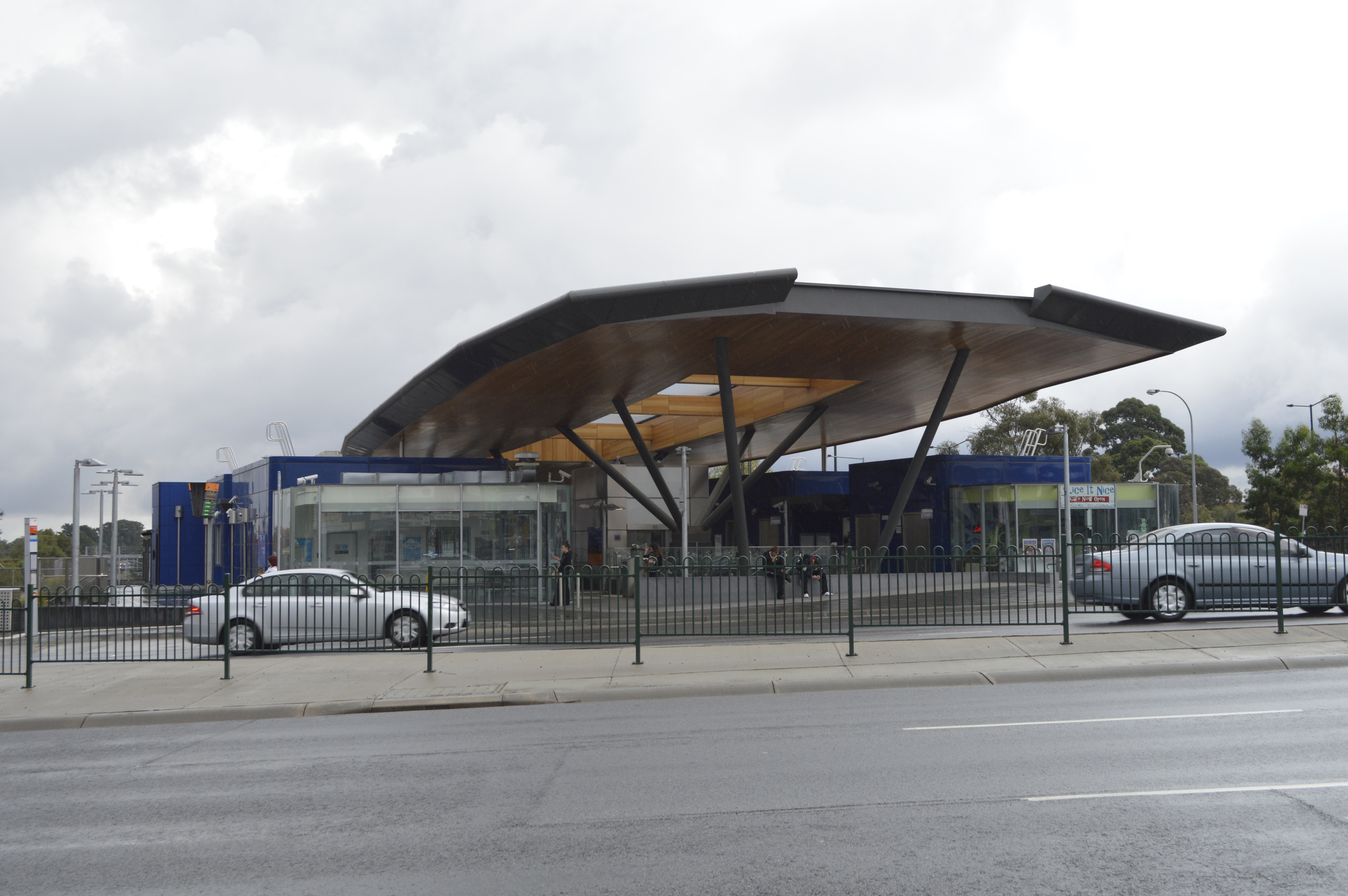
Heatherdale Station Entrance Final Stages Of Construction (32588846592)
Heatherdale is a neighbourhood of Mitcham, Victoria, Mitcham, in Melbourne's eastern suburbs, centred on the Heatherdale railway station, on the Lilydale railway line, Lilydale and Belgrave railway line, Belgrave railway lines. It is in the Local government areas of Victoria, local government area of the City of Whitehorse. Heatherdale junior football club existed from 1969 until 1997 when it merged with Heathmont Junior football club to become the Heathmont Jets. Localities of Melbourne City of Whitehorse {{Melbourne-geo-stub ... [...More Info...] [...Related Items...] OR: [Wikipedia] [Google] [Baidu] |
Mitcham, Victoria
Mitcham is a suburb of Melbourne, Victoria, Australia, 20 km east from Melbourne's Central Business District, located within the City of Whitehorse local government area. Mitcham recorded a population of 16,795 at the 2021 census. History Mitcham was named after Mitcham Grove, a farm property that was owned by William Slater, who grew roses and herbs for perfumes and remedies. From its settlement in the 1860s, the Mitcham area was generally used for orchards, brickmaking and pottery. Mitcham Post Office opened on 1 June 1884. From its settlement in the 1860s, the Mitcham area was generally used for orchards, brickmaking and pottery. A Heatherdale Post Office opened in 1948 and closed in 1971. The Mitcham North Post Office opened in 1960. However, since the 1950s post war expansion, Mitcham has become a suburban area. Demographics In the 2016 census the population of Mitcham was 16,148, approximately 51.7% female and 48.3% male. The median/average age of the people ... [...More Info...] [...Related Items...] OR: [Wikipedia] [Google] [Baidu] |
Melbourne
Melbourne ( ; Boonwurrung/Woiwurrung: ''Narrm'' or ''Naarm'') is the capital and most populous city of the Australian state of Victoria, and the second-most populous city in both Australia and Oceania. Its name generally refers to a metropolitan area known as Greater Melbourne, comprising an urban agglomeration of 31 local municipalities, although the name is also used specifically for the local municipality of City of Melbourne based around its central business area. The metropolis occupies much of the northern and eastern coastlines of Port Phillip Bay and spreads into the Mornington Peninsula, part of West Gippsland, as well as the hinterlands towards the Yarra Valley, the Dandenong and Macedon Ranges. It has a population over 5 million (19% of the population of Australia, as per 2021 census), mostly residing to the east side of the city centre, and its inhabitants are commonly referred to as "Melburnians". The area of Melbourne has been home to Aboriginal ... [...More Info...] [...Related Items...] OR: [Wikipedia] [Google] [Baidu] |
Heatherdale Railway Station
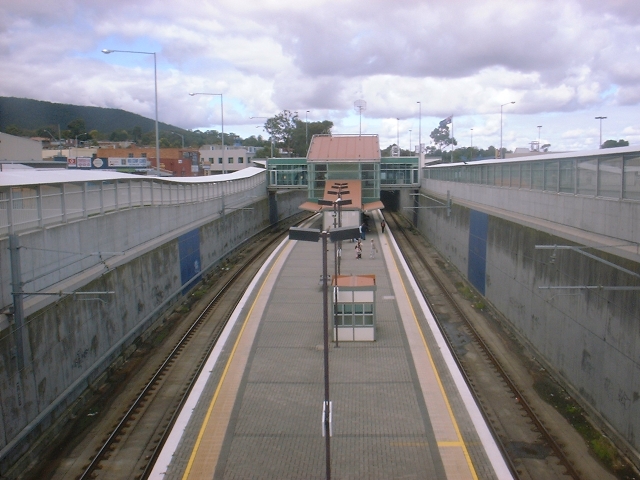
Heatherdale railway station is located on the Lilydale and Belgrave lines in Victoria, Australia. It serves the eastern Melbourne suburb of Ringwood, and opened on 7 September 1958.Heatherdale Vicsig History Heatherdale station opened on 7 September 1958, and was named after the locality of the same name, itself named after "''Heatherdale''", a farm that was owned by William Witt. When the station opened, it was located west of the former Heatherdale Road , which was provided w ...[...More Info...] [...Related Items...] OR: [Wikipedia] [Google] [Baidu] |
Lilydale Railway Line
The Lilydale railway line is a commuter railway line operating between Flinders Street in the Melbourne central business district and Lilydale through Melbourne's eastern suburbs including Richmond, Cremorne, Burnley, Hawthorn, Hawthorn East, Camberwell, Canterbury, Surrey Hills, Mont Albert, Box Hill, Blackburn, Nunawading, Mitcham, Ringwood, Ringwood East, Croydon, Mooroolbark, and Lilydale. It is part of the Melbourne rail network operated by Metro Trains Melbourne. Description The Lilydale line runs through Melbourne's eastern suburbs across mostly gentle hills (but with some steeper sections near the end of the line), having few straight or level sections. Earthworks are significant, with deep cuttings at Hawthorn, Camberwell, Box Hill, Heatherdale and near Croydon. Around Glenferrie and Auburn the line has been raised above the surrounding area on an embankment to avoid level crossings of several roads. All but two level crossings have been eliminated between th ... [...More Info...] [...Related Items...] OR: [Wikipedia] [Google] [Baidu] |
Belgrave Railway Line
The Belgrave railway line is a commuter rail line operating between Flinders Street in the Melbourne central business district and Belgrave, through the eastern suburbs of Melbourne, including Richmond, Cremorne, Burnley, Hawthorn, Hawthorn East, Camberwell, Canterbury, Surrey Hills, Mont Albert, Box Hill, Blackburn, Nunawading, Mitcham, Ringwood, Heathmont, Bayswater, Boronia, Ferntree Gully, Upper Ferntree Gully, Upwey, Tecoma and Belgrave. It is part of the Melbourne rail network, operated by Metro Trains Melbourne. Beyond Belgrave, the narrow-gauge line has been restored as the Puffing Billy Railway, which runs to the original terminus of Gembrook. Infrastructure The broad-gauge line shares four tracks to Burnley, where the Glen Waverley line branches off. The line is triple track to Box Hill, and double track to Ringwood, where the Lilydale line branches off. The line remains double track to Ferntree Gully, and is then single track to Belgrave, with passing lo ... [...More Info...] [...Related Items...] OR: [Wikipedia] [Google] [Baidu] |
Local Government Areas Of Victoria
This is a list of local government areas (LGAs) in Victoria, sorted by region. Also referred to as municipalities, the 79 Victorian LGAs are classified as cities (34), shires (38), rural cities (6) and boroughs (1). In general, an urban or suburban LGA is called a city and is governed by a city council, while a rural LGA covering a larger rural area is usually called a shire and is governed by a shire council. Local councils have the same administrative functions and similar political structures, regardless of their classification. Greater Melbourne Regional Victoria Barwon South West Grampians Gippsland Hume Loddon Mallee See also * Government of Australia *Australian Local Government Association *Municipal Association of Victoria References External links *Victorian Local Governance Association {{Politics of Australia * Local government areas A local government area (LGA) is an administrative division of a country that a local g ... [...More Info...] [...Related Items...] OR: [Wikipedia] [Google] [Baidu] |
City Of Whitehorse
The City of Whitehorse is a local government area in Victoria, Australia in the eastern suburbs of Melbourne. It has an area of and in June 2018, Whitehorse had a population of 176,196. Whitehorse was formed in December 1994 by the amalgamation of the former cities of Box Hill and Nunawading. The name Whitehorse came from the White Horse Inn, a tavern originally located in the area in the late 19th century. This name was applied to the major thoroughfare, Whitehorse Road, which runs through the municipality today. In the original proposals for council amalgamations in Melbourne, Whitehorse was a suggested name for an area comprising the City of Box Hill, with the addition of residents east of Union Road (part of the old City of Camberwell). The affected residents were unhappy, believing an alignment with Box Hill would lower the value of their properties. A second proposal featured the current boundaries of Whitehorse. The City of Nunawading proposed the name "City of Koorn ... [...More Info...] [...Related Items...] OR: [Wikipedia] [Google] [Baidu] |
Localities Of Melbourne
{{disambiguation ...
Locality may refer to: * Locality (association), an association of community regeneration organizations in England * Locality (linguistics) * Locality (settlement) * Suburbs and localities (Australia), in which a locality is a geographic subdivision in rural areas of Australia Science * Locality (astronomy) * Locality of reference, in computer science * Locality (statistics) * Principle of locality, in physics See also * Local (other) * Type locality (other) Type locality may refer to: * Type locality (biology) * Type locality (geology) See also * Local (other) * Locality (other) {{disambiguation ... [...More Info...] [...Related Items...] OR: [Wikipedia] [Google] [Baidu] |


