|
Ghizer District (2019–)
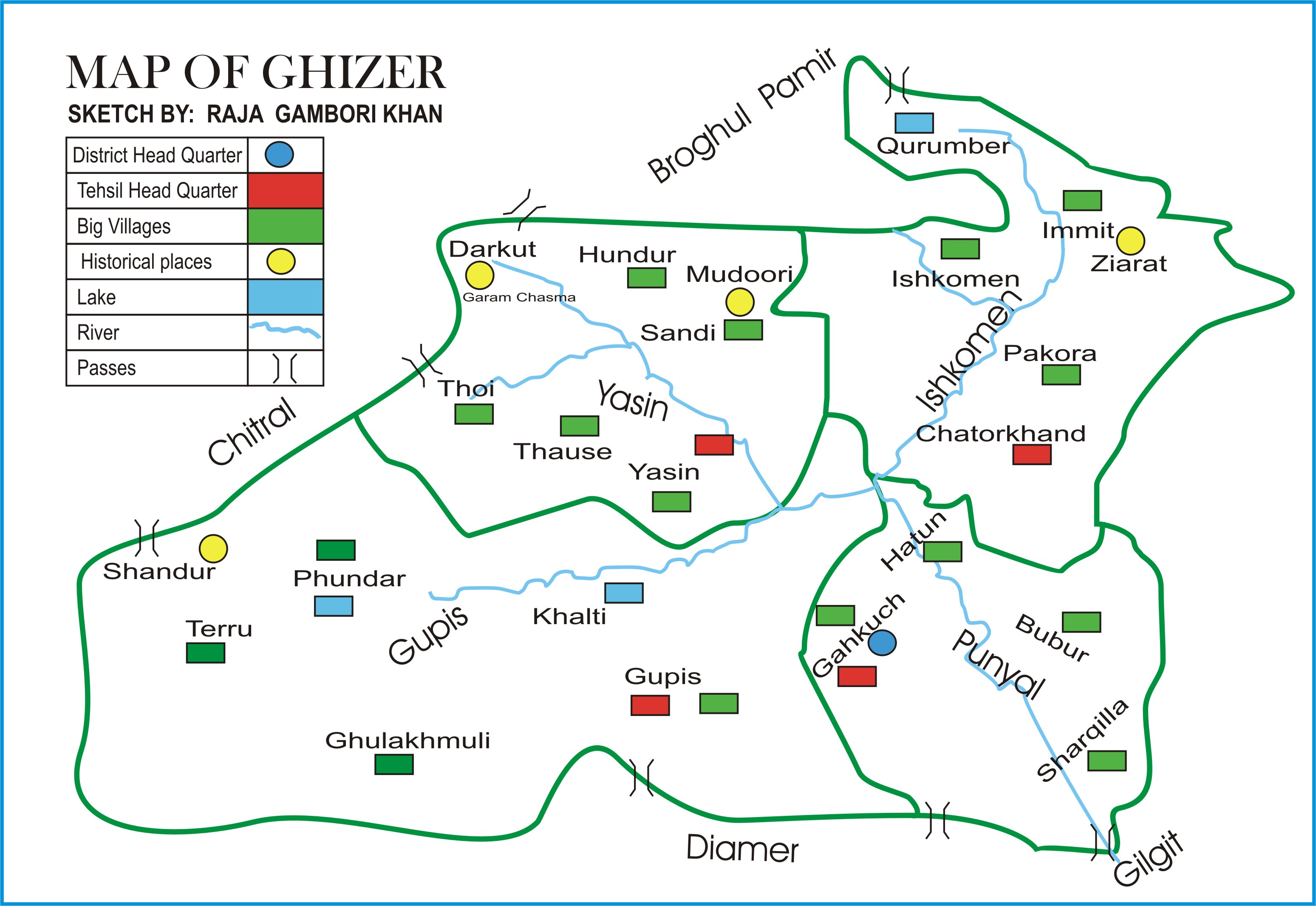
The Ghizer District ( ur, ) is one of the 14 districts of Pakistan-administered territory of Gilgit-Baltistan. The former Ghizer District that existed from 1974 to 2019 spanned the entire upper Gilgit River Valley (also known as the Ghizer River Valley). In 2019, the former district was divided into the Gupis-Yasin District in the west and the present, smaller Ghizer District in the east. The word Ghizer came from the name "Gherz" which means "refugees" in Khowar. "Gherz" is a village in Golaghmuli Valley. The Chitral State under the suzerainty of the British Raj forced some people to migrate towards Gupis, Yasin, Phander, Ishkomen and also to Punial. They were settled in the area between Chitral and Gupis. The area came to be called "Gherz" and the people "Gherzic". Ghizer District comprised Punial, Gupis, Yasen, Phander and Ishkoman Valleys. The major portion of its area was ruled over by Brooshay Rajas. Currently, the living Raja families in the District have no administrat ... [...More Info...] [...Related Items...] OR: [Wikipedia] [Google] [Baidu] |
Districts Of Gilgit-Baltistan
The number rose from seven to ten in 2016 after the addition of 2 districts in Baltistan Valley and the bifurcation of the Hunza–Nagar District, Hunza-Nagar district. , there are 14 districts in Gilgit-Baltistan, Gilgit Baltistan, 5 in the Baltistan Division, 5 in the Gilgit Division and 4 in the Diamer Division. The number rose from seven to ten in 2016 after the addition of 2 districts in Baltistan Valley and the bifurcation of the Hunza–Nagar District, Hunza-Nagar district. In 2019, Darel District, Darel, Tangir District, Tangir, Gupis-Yasin District, Gupis–Yasin and Roundu District, Roundu were announced as new districts. Each district is further divided into tehsils and Union councils of Pakistan, union councils. Districts of Gilgit Baltistan See also * List of tehsils of Gilgit-Baltistan References {{DEFAULTSORT:Districts of Gilgit-Baltistan Districts of Gilgit-Baltistan, Districts of Pakistan, Gilgit-Baltistan ... [...More Info...] [...Related Items...] OR: [Wikipedia] [Google] [Baidu] |
Jammu And Kashmir (princely State)
Jammu and Kashmir, officially known as the Princely State of Kashmir and Jammu, was a princely state during the Company rule in India from 1757 to 1858 as well as the British Raj in India from 1846 to 1952. The princely state was created after the First Anglo-Sikh War, from the territories that had earlier been in the Sikh Empire. At the time of the partition of India and the political integration of India, Hari Singh, the ruler of the state, delayed making a decision about the future of his state. However, an uprising in the western districts of the state followed by an attack by raiders from the neighbouring Northwest Frontier Province, supported by Pakistan, forced his hand. On 26 October 1947, Hari Singh acceded to India in return for the Indian military being airlifted to Kashmir to engage the Pakistan-supported forces, starting the Kashmir conflict. The western and northern districts presently known as Azad Kashmir and Gilgit-Baltistan passed to the control of Pakistan, ... [...More Info...] [...Related Items...] OR: [Wikipedia] [Google] [Baidu] |
Darel District
The Darel District (Urdu: ) is a district in Gilgit-Baltistan territory of Pakistan. It is located towards south-west of Gilgit District. Its population lives mainly in the valley of the Darel River, a right tributary of the Indus River. OpenStreetMap, retrieved 22 January 2022. History Prior to 2019, the Darel District was a tehsil of the , along with Tangir and Chilas.Geography The Darel District is bounded on the north by the Ghizer District, on the north-east by the |
Tangir District
The Tangir District (Urdu: ) is a district in Gilgit-Baltistan territory of Pakistan. It is located at a distance of 67 km from Chilas. Its population lives mainly in the valley of the Tangir River, a right tributary of the Indus River. OpenStreetMap, retrieved 22 January 2022. History Prior to 2019, the Tangir District was a tehsil of the , along with Darel and Chilas. The government of Pakistan announced the district carved out of Diamer district of Gilgit-Baltistan.Geography The Tangir District is bounded on the north by the |
Gilgit District
The Gilgit District ( ur, ) is one of the 14 districts of Pakistan-administered territory of Gilgit-Baltistan. The headquarters of the district is the town of Gilgit. According to the 1998 census, the Gilgit District had a population of 243,324. The district includes Gilgit (the capital city), the Bagrot Valley, Juglot, Danyore, Sultanabad, Naltar Peak, and the Nomal Valley. The highest peak in the district is Distaghil Sar , which is the seventh-highest peak in Pakistan and 19th highest in the world. Administration The Gilgit District is divided into three tehsils: * Danyor Tehsil * Gilgit Tehsil * Juglot Tehsil Education According to the Alif Ailaan Pakistan District Education Rankings 2015, the Gilgit District was ranked 35th out of 148 districts in terms of education. In terms of facilities and infrastructure, the district was ranked 67th out of 148. Geography The Gilgit District is bounded on the north by the Nagar District, on the east by the Shigar Distr ... [...More Info...] [...Related Items...] OR: [Wikipedia] [Google] [Baidu] |
Nagar District
The Nagar District ( ur, ) is one of the 14 districts of Pakistan-administered territory of Gilgit-Baltistan. The Nagar District was established in 2015 by the division of the Hunza–Nagar District into two districts: the Hunza District and the Nagar District. The Nagar District is bounded on the north and north-east by the Hunza District, on the south-east by the Shigar District, on the south by the Gilgit District, and on the west by the Gupis-Yasin District. The district headquarters in the town of Nagarkhas. Administration The District Nagar administratively comprises two Tehsils, Tehsil Nagar-I and Tehsil Nagar-II. All the villages of upper Nagar including Shayar, Askurdas, Sumayar, Nagarkhas, Hoper Valley, and Hispar come under the Tehsil Nagar-I. While all the villages of lower Nagar including Bar, Chalt, Buladas, Chaprote, Skandarabad, Jafarabad, Nilt, Thol, Ghulmet, Pisan, Minapin, Meacher, Dadhimal, Phekar, and Hakuchar are the par of Tehsil Nagar-II. Political r ... [...More Info...] [...Related Items...] OR: [Wikipedia] [Google] [Baidu] |
Hunza District
The Hunza District ( ur, ) is one of the 14 districts of the Pakistani province of Gilgit-Baltistan. It was established in 2015 by the division of the Hunza–Nagar District in accordance with a government decision to establish more administrative units in Gilgit-Baltistan. The district headquarters is the town of Karimabad. Geography The Hunza District is bounded on the north and east by the Kashgar Prefecture of China's Xinjiang Uyghur Autonomous Region, on the south by the Nagar District and the Shigar District, on the west by the Ghizer District, and on the north-west by the Wakhan District of Afghanistan's Badakhshan Province. The Hunza District represents the northernmost region of the Indian subcontinent. It is home to the historic passes through the Karakoram Mountains (the Killik, Mintaka, Khunjerab, and Shimshal passes) through which trade and religion passed between Central Asia, China, and India for centuries. The present-day Karakoram Highway passes through t ... [...More Info...] [...Related Items...] OR: [Wikipedia] [Google] [Baidu] |
Badakhshan Province
Badakhshan Province (Persian/ Uzbek: , ''Badaxšān'') is one of the 34 provinces of Afghanistan, located in the northeastern part of the country. It is bordered by Tajikistan's Gorno-Badakhshan in the north and the Pakistani regions of Lower and Upper Chitral and Gilgit-Baltistan in the southeast. It also has a 91-kilometer (57-mile) border with China in the east. It is part of a broader historical Badakhshan region, parts of which now also lie in Tajikistan and China. The province contains 22 districts, over 1,200 villages and approximately 1 055 00people. Fayzabad, Badakhshan, Fayzabad serves as the provincial capital. Resistance activity has been reported in the province since the 2021 Taliban takeover of Afghanistan. Etymology Badakhshan's name comes from the Middle Persian word "badaxš", which is an official title. The word "ān" is a suffix which demonstrates a place's name; therefore the word "badaxšān" means a place belonging to a person called "badaxš". Duri ... [...More Info...] [...Related Items...] OR: [Wikipedia] [Google] [Baidu] |
Afghanistan
Afghanistan, officially the Islamic Emirate of Afghanistan,; prs, امارت اسلامی افغانستان is a landlocked country located at the crossroads of Central Asia and South Asia. Referred to as the Heart of Asia, it is bordered by Pakistan to the Durand Line, east and south, Iran to the Afghanistan–Iran border, west, Turkmenistan to the Afghanistan–Turkmenistan border, northwest, Uzbekistan to the Afghanistan–Uzbekistan border, north, Tajikistan to the Afghanistan–Tajikistan border, northeast, and China to the Afghanistan–China border, northeast and east. Occupying of land, the country is predominantly mountainous with plains Afghan Turkestan, in the north and Sistan Basin, the southwest, which are separated by the Hindu Kush mountain range. , Demographics of Afghanistan, its population is 40.2 million (officially estimated to be 32.9 million), composed mostly of ethnic Pashtuns, Tajiks, Hazaras, and Uzbeks. Kabul is the country's largest city and ser ... [...More Info...] [...Related Items...] OR: [Wikipedia] [Google] [Baidu] |
Wakhan District
Wakhan District is one of the 28 districts of Badakhshan Province in eastern Afghanistan. The district has a border with neighboring Tajikistan in the north, Xinjiang in China to the east, and Pakistan to the south (specifically Gilgit-Baltistan and Chitral District). See also * Afghanistan–China border * Wakhan * Wakhan Corridor External links * (Radio Television Afghanistan National Radio Television Afghanistan (RTA; ps, ''Da Afġanistan Mīlī Radīo Telvizoon'', fa, ''Rādīo Telvizoon-e Mīlī-e Afġānestān'', branded as ملی (meaning ''national'')) is the public-broadcasting organization of Afghanista ... (RTA Pashto)) * (RTA Dari) * * {{Authority control Districts of Badakhshan Province Wakhan ... [...More Info...] [...Related Items...] OR: [Wikipedia] [Google] [Baidu] |
Khyber Pakhtunkhwa Province
Khyber Pakhtunkhwa (; ps, خېبر پښتونخوا; Urdu, Hindko: خیبر پختونخوا) commonly abbreviated as KP or KPK, is one of the four provinces of Pakistan. Located in the northwestern region of the country, Khyber Pakhtunkhwa is the smallest province of Pakistan by land area and the third-largest province by population after Punjab and Sindh. It shares land borders with the Pakistani provinces of Balochistan to the south, Punjab to the south-east and province of Gilgit-Baltistan to the north and north-east, as well as Islamabad Capital Territory to the east, Autonomous Territory of Azad Jammu and Kashmir to the north-east. It shares an international border with Afghanistan to the west. Khyber Pakhtunkhwa is known as a tourist hot spot for adventurers and explorers and has a varied landscape ranging from rugged mountain ranges, valleys, plains surrounded by hills, undulating submontane areas and dense agricultural farms. While it is the third-largest ... [...More Info...] [...Related Items...] OR: [Wikipedia] [Google] [Baidu] |
Pakistan
Pakistan ( ur, ), officially the Islamic Republic of Pakistan ( ur, , label=none), is a country in South Asia. It is the world's List of countries and dependencies by population, fifth-most populous country, with a population of almost 243 million people, and has the world's Islam by country#Countries, second-largest Muslim population just behind Indonesia. Pakistan is the List of countries and dependencies by area, 33rd-largest country in the world by area and 2nd largest in South Asia, spanning . It has a coastline along the Arabian Sea and Gulf of Oman in the south, and is bordered by India to India–Pakistan border, the east, Afghanistan to Durand Line, the west, Iran to Iran–Pakistan border, the southwest, and China to China–Pakistan border, the northeast. It is separated narrowly from Tajikistan by Afghanistan's Wakhan Corridor in the north, and also shares a maritime border with Oman. Islamabad is the nation's capital, while Karachi is its largest city and fina ... [...More Info...] [...Related Items...] OR: [Wikipedia] [Google] [Baidu] |


.png)
