|
Gulf Of Cádiz
The Gulf of Cádiz (, ) is the arm of the Atlantic Ocean between Cabo de Santa Maria, the southernmost point of mainland Portugal; and Cape Trafalgar on the Spanish coast at the western end of the Strait of Gibraltar. Two major rivers, the Guadalquivir and the Guadiana, as well as smaller rivers, like the Odiel, the Tinto, and the Guadalete, reach the ocean here. The Gulf of Cádiz is located in the north-eastern Atlantic Ocean between 34°N and 37°15′N and 6°W to 9°45′W. It is enclosed by the southern Iberian and northern Moroccan margins, west of Strait of Gibraltar. Geology The geological history of the Gulf of Cádiz is intimately related to plate tectonic interaction between Southern Eurasia and North Africa and is driven by two major mechanisms: * subduction associated with the westward emplacement of the Gibraltar Arc and formation of the Gulf of Cádiz accretionary wedge. The current activity of the subduction is unclear, with some advocating ongoing activ ... [...More Info...] [...Related Items...] OR: [Wikipedia] [Google] [Baidu] |
Atlantic Ocean
The Atlantic Ocean is the second largest of the world's five borders of the oceans, oceanic divisions, with an area of about . It covers approximately 17% of Earth#Surface, Earth's surface and about 24% of its water surface area. During the Age of Discovery, it was known for separating the New World of the Americas (North America and South America) from the Old World of Afro-Eurasia (Africa, Asia, and Europe). Through its separation of Afro-Eurasia from the Americas, the Atlantic Ocean has played a central role in the development of human society, globalization, and the histories of many nations. While the Norse colonization of North America, Norse were the first known humans to cross the Atlantic, it was the expedition of Christopher Columbus in 1492 that proved to be the most consequential. Columbus's expedition ushered in an Age of Discovery, age of exploration and colonization of the Americas by European powers, most notably Portuguese Empire, Portugal, Spanish Empire, Sp ... [...More Info...] [...Related Items...] OR: [Wikipedia] [Google] [Baidu] |
Moroccan Margin
Moroccan may refer to: * Something or someone from, or related to the country of Morocco ** Moroccans, or Moroccan people ** Moroccan Arabic, spoken in Morocco ** Moroccan Jews See also * Morocco leather Morocco leather (also known as Levant, the French Maroquin, Turkey, or German Saffian from Safi, a Moroccan town famous for leather) is a vegetable-tanned leather known for its softness, pliability, and ability to take color. It has been widely ... * * {{disambig Language and nationality disambiguation pages ... [...More Info...] [...Related Items...] OR: [Wikipedia] [Google] [Baidu] |
Lophelia
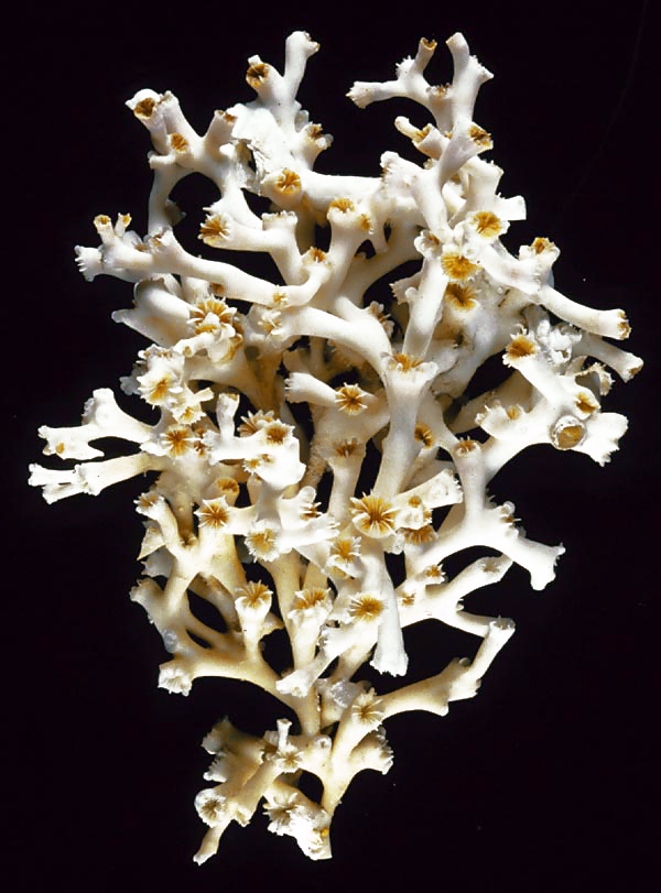
''Lophelia pertusa'', the only species in the genus ''Lophelia'', is a cold-water coral that grows in the deep waters throughout the North Atlantic ocean, as well as parts of the Caribbean Sea and Alboran Sea. Although ''L. pertusa'' reefs are home to a diverse community, the species is extremely slow growing and may be harmed by destructive fishing practices, or oil exploration and extraction. Biology ''Lophelia pertusa'' is a reef building, deep water coral, but it does not contain zooxanthellae, the symbiotic algae which lives inside most tropical reef building corals. ''Lophelia'' lives at a temperature range from about and at depths between and over , but most commonly at depths of , where there is no sunlight. As a coral, it represents a colonial organism, which consists of many individuals. New polyps live and build upon the calcium carbonate skeletal remains of previous generations. Living coral ranges in colour from white to orange-red; each polyp has up to 16 t ... [...More Info...] [...Related Items...] OR: [Wikipedia] [Google] [Baidu] |
Madrepora
''Madrepora'' (Spanish, "mother of pores") is a genus of stony corals, often found forming reefs or islands in tropical locations. The names Madrepore and Madreporaria were formerly applied universally to any stony coral of the family Scleractinia. They reproduce in three separate ways, as discovered by the marine zoologist Anne Thynne (1800–1866). It is commonly known as horn coral. A colony is branched with small polyps in cylindrical cups separated by a perforated coenosteum. Terminal polyps bear six tentacles, while lateral polyps bear twelve tentacles. Madrepora is economically important, since it contributes to the formation of coral reefs. Species Species include: * '' Madrepora arbuscula'' (Moseley, 1881) * '' Madrepora astroites'' Forskål, 1775 * '' Madrepora carolina'' (Pourtalès, 1871) * '' Madrepora minutiseptum'' Cairns & Zibrowius, 1997 * '' Madrepora oculata'' Linnaeus, 1758 Events January–March * January 1 – Swedish biologist Carl Lin ... [...More Info...] [...Related Items...] OR: [Wikipedia] [Google] [Baidu] |
Siboglinidae
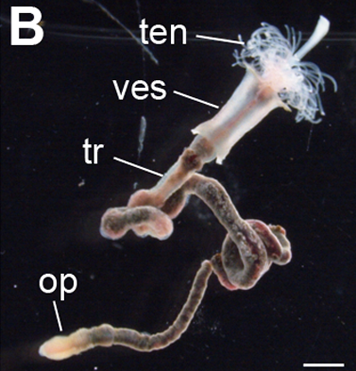
Siboglinidae is a family (biology), family of polychaete Annelida, annelid worms whose members made up the former phylum, phyla Pogonophora and Vestimentifera (the giant tube worms). The family is composed of around 100 species of vermiform creatures which live in thin tubes buried in sediment (Pogonophora) or in tubes attached to hard substratum (Vestimentifera) at ocean depths ranging from . They can also be found in association with hydrothermal vents, methane seeps, sunken plant material, and Whale fall, whale carcasses. The first specimen was dredged from the waters of Indonesia in 1900. These specimens were given to French zoologist Maurice Caullery, who studied them for nearly 50 years. Anatomy Most siboglinids are less than in diameter, but in length. They inhabit tubular structures composed of chitin which are fixed to rocks or substrates. The tubes are often clustered together in large colonies. Their bodies are divided into four regions. The anterior end is called th ... [...More Info...] [...Related Items...] OR: [Wikipedia] [Google] [Baidu] |
Mud Volcano
A mud volcano or mud dome is a landform created by the eruption of mud or Slurry, slurries, water and gases. Several geological processes may cause the formation of mud volcanoes. Mud volcanoes are not true Igneous rock, igneous volcanoes as they do not produce lava and are not necessarily driven by magmatic activity. Mud volcanoes may range in size from merely 1 or 2 meters high and 1 or 2 meters wide, to 700 meters high and 10 kilometers wide. Smaller mud exudations are sometimes referred to as mud-pots. The mud produced by mud volcanoes is mostly formed as hot water, which has been heated deep below the Earth's surface, begins to mix and blend with subterranean mineral deposits, thus creating the mud slurry exudate. This material is then forced upwards through a geological fault or fissure due to local subterranean pressure imbalances. Mud volcanoes are associated with subduction zones and about 1100 have been identified on or near land. The temperature of any given active mu ... [...More Info...] [...Related Items...] OR: [Wikipedia] [Google] [Baidu] |
Cold Seep
A cold seep (sometimes called a cold vent) is an area of the ocean floor where seepage of fluids rich in hydrogen sulfide, methane, and other hydrocarbons occurs, often in the form of a brine pool. ''Cold'' does not mean that the temperature of the seepage is lower than that of the surrounding sea water; on the contrary, its temperature is often slightly higher. The "cold" is relative to the very warm (at least ) conditions of a hydrothermal vent. Cold seeps constitute a biome supporting several endemic species. Cold seeps develop unique topography over time, where reactions between methane and seawater create carbonate rock formations and reefs. These reactions may also be dependent on bacterial activity. Ikaite, a hydrous calcium carbonate, can be associated with oxidizing methane at cold seeps. Types Types of cold seeps can be distinguished according to the depth, as shallow cold seeps and deep cold seeps. Cold seeps can also be distinguished in detail, as follow ... [...More Info...] [...Related Items...] OR: [Wikipedia] [Google] [Baidu] |
Hydrocarbon
In organic chemistry, a hydrocarbon is an organic compound consisting entirely of hydrogen and carbon. Hydrocarbons are examples of group 14 hydrides. Hydrocarbons are generally colourless and Hydrophobe, hydrophobic; their odor is usually faint, and may be similar to that of gasoline or Naphtha, lighter fluid. They occur in a diverse range of molecular structures and phases: they can be gases (such as methane and propane), liquids (such as hexane and benzene), low melting solids (such as paraffin wax and naphthalene) or polymers (such as polyethylene and polystyrene). In the fossil fuel industries, ''hydrocarbon'' refers to naturally occurring petroleum, natural gas and coal, or their hydrocarbon derivatives and purified forms. Combustion of hydrocarbons is the main source of the world's energy. Petroleum is the dominant raw-material source for organic commodity chemicals such as solvents and polymers. Most anthropogenic (human-generated) emissions of greenhouse gases are eithe ... [...More Info...] [...Related Items...] OR: [Wikipedia] [Google] [Baidu] |
Nubia
Nubia (, Nobiin language, Nobiin: , ) is a region along the Nile river encompassing the area between the confluence of the Blue Nile, Blue and White Nile, White Niles (in Khartoum in central Sudan), and the Cataracts of the Nile, first cataract of the Nile (south of Aswan in southern Egypt) or more strictly, Al Dabbah, Sudan, Al Dabbah. It was the seat of one of the earliest civilizations of ancient Africa, the Kerma culture, which lasted from around 2500 BC until its conquest by the New Kingdom of Egypt under Pharaoh Thutmose I around 1500 BC, whose heirs ruled most of Nubia for the next 400 years. Nubia was home to several African empires, empires, most prominently the Kingdom of Kush, which conquered Egypt in the eighth century BC during the reign of Piye and ruled the country as its Twenty-fifth Dynasty of Egypt, 25th Dynasty. From the 3rd century BC to 3rd century AD, northern Nubia was invaded and annexed to Egypt, ruled by the Ptolemaic Kingdom, Greeks and Roman Empire, R ... [...More Info...] [...Related Items...] OR: [Wikipedia] [Google] [Baidu] |
Iberia
The Iberian Peninsula ( ), also known as Iberia, is a peninsula in south-western Europe. Mostly separated from the rest of the European landmass by the Pyrenees, it includes the territories of peninsular Spain and Continental Portugal, comprising most of the region, as well as the tiny adjuncts of Andorra, Gibraltar, and, pursuant to the traditional definition of the Pyrenees as the peninsula's northeastern boundary, a small part of France. With an area of approximately , and a population of roughly 53 million, it is the second-largest European peninsula by area, after the Scandinavian Peninsula. Etymology The Iberian Peninsula has always been associated with the River Ebro (Ibēros in ancient Greek and Ibērus or Hibērus in Latin). The association was so well known it was hardly necessary to state; for example, Ibēria was the country "this side of the Ibērus" in Strabo. Pliny goes so far as to assert that the Greeks had called "the whole of the peninsula" Hiberia beca ... [...More Info...] [...Related Items...] OR: [Wikipedia] [Google] [Baidu] |
Subduction
Subduction is a geological process in which the oceanic lithosphere and some continental lithosphere is recycled into the Earth's mantle at the convergent boundaries between tectonic plates. Where one tectonic plate converges with a second plate, the heavier plate dives beneath the other and sinks into the mantle. A region where this process occurs is known as a subduction zone, and its surface expression is known as an arc-trench complex. The process of subduction has created most of the Earth's continental crust. Rates of subduction are typically measured in centimeters per year, with rates of convergence as high as 11 cm/year. Subduction is possible because the cold and rigid oceanic lithosphere is slightly denser than the underlying asthenosphere, the hot, ductile layer in the upper mantle. Once initiated, stable subduction is driven mostly by the negative buoyancy of the dense subducting lithosphere. The down-going slab sinks into the mantle largely under its own ... [...More Info...] [...Related Items...] OR: [Wikipedia] [Google] [Baidu] |


