|
Guide Seamount
Guide Seamount is a seamount in the eastern Pacific Ocean, about 16.6 ±0.5 million years old. It is similar in shape and orientation to the nearby Davidson, Pioneer, Rodriguez, and Gumdrop seamounts. It is named for the United States Coast and Geodetic Survey survey ship ''USC&GS Guide''. Guide Seamount is constructed of four nearly parallel volcanic ridges, separated by sediment-filled throughs. These are aligned parallel to magnetic anomalies in the underlying oceanic crust. It is very similar in shape and structure to the nearby Davidson Seamount, except that it is smaller, at approximately by . It rises about above the seafloor and sits at depth of . The lavas from Guide are mostly alkalic basalt, hawaiite, mugearite with some pyroclastic flow A pyroclastic flow (also known as a pyroclastic density current or a pyroclastic cloud) is a fast-moving current of hot gas and volcanic matter (collectively known as tephra) that flows along the ground away from a volcano at av ... [...More Info...] [...Related Items...] OR: [Wikipedia] [Google] [Baidu] |
United States Coast And Geodetic Survey
The United States Coast and Geodetic Survey (abbreviated USC&GS), known from 1807 to 1836 as the Survey of the Coast and from 1836 until 1878 as the United States Coast Survey, was the first scientific agency of the United States Government. It existed from 1807 to 1970, and throughout its history was responsible for mapping and charting the coast of the United States, and later the coasts of U.S. territories. In 1871, it gained the additional responsibility of surveying the interior of the United States and geodesy became a more important part of its work, leading to it being renamed the U.S. Coast and Geodetic Survey in 1878. Long the U.S. Government's only scientific agency, the Survey accumulated other scientific and technical responsibilities as well, including astronomy, cartography, meteorology, geology, geophysics, hydrography, navigation, oceanography, exploration, pilotage, tides, and topography. It also was responsible for the standardization of weights and measures th ... [...More Info...] [...Related Items...] OR: [Wikipedia] [Google] [Baidu] |
Mugearite
Mugearite () is a type of oligoclase-bearing basalt, comprising olivine, apatite, and opaque oxides. The main feldspar in mugearite is oligoclase. Mugearite is a sodium-rich member of the alkaline magma series. In the TAS classification of volcanic rock, mugearite is classified as sodium-rich basaltic trachyandesite. Examples Western Scotland Mugearite was first identified at Mugeary on the island of Skye, Scotland by Alfred Harker in 1904. Outcrops of mugearite also occur on the island of Isle of Mull, Mull. These examples of mugearite were formed during a period of continental flood basalt volcanic activity that happened in western Scotland during the Paleogene Period (geology), period of the Earth's geological history, when the North Atlantic Ocean opened between Europe and North America. Oceanic islands Mugearite has been erupted by the volcanoes of some High island, oceanic islands at Hotspot (geology), hotspots. Examples are Hawaii (island), Hawaii, Ascension Island, Sai ... [...More Info...] [...Related Items...] OR: [Wikipedia] [Google] [Baidu] |
Hawaiite
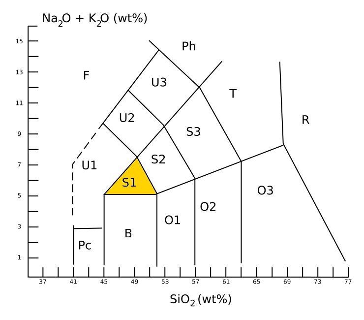
Hawaiite is an olivine basalt with a composition between alkali basalt and mugearite. It was first used as a name for some lavas found on the island of Hawaii. It occurs during the later stages of volcanic activity on oceanic islands such as Hawaii, which happens to be when the alkaline metals are most present. In gemology, hawaiite is a colloquial term for Hawaii-originated peridot, which is a gem-quality form of the mineral olivine. Description Hawaiite is an aphanitic (fine-grained) volcanic rock produced by rapid cooling of lava moderately poor in silica and enriched in alkali metal oxides (potassium oxide plus sodium oxide). It is often impractical to determine the mineral composition of such a fine-grained rock, and so hawaiite is defined chemically. Under the TAS classification, hawaiite is sodic trachybasalt, with a silica content close to 49 wt%, a total alkali metal oxide content close to 6%, and wt% > wt% + 2. This places hawaiite in the S1 field of the TAS dia ... [...More Info...] [...Related Items...] OR: [Wikipedia] [Google] [Baidu] |
Basalt
Basalt (; ) is an aphanite, aphanitic (fine-grained) extrusive igneous rock formed from the rapid cooling of low-viscosity lava rich in magnesium and iron (mafic lava) exposed at or very near the planetary surface, surface of a terrestrial planet, rocky planet or natural satellite, moon. More than 90% of all volcanic rock on Earth is basalt. Rapid-cooling, fine-grained basalt is chemically equivalent to slow-cooling, coarse-grained gabbro. The eruption of basalt lava is observed by geologists at about 20 volcanoes per year. Basalt is also an important rock type on other planetary bodies in the Solar System. For example, the bulk of the plains of volcanism on Venus, Venus, which cover ~80% of the surface, are basaltic; the lunar mare, lunar maria are plains of flood-basaltic lava flows; and basalt is a common rock on the surface of Mars. Molten basalt lava has a low viscosity due to its relatively low silica content (between 45% and 52%), resulting in rapidly moving lava flo ... [...More Info...] [...Related Items...] OR: [Wikipedia] [Google] [Baidu] |
MBARI
The Monterey Bay Aquarium Research Institute (MBARI) is a private, non-profit oceanographic research center in Moss Landing, California. MBARI was founded in 1987 by David Packard, and is primarily funded by the David and Lucile Packard Foundation. Christopher Scholin serves as the institute's president and chief executive officer, managing a work force of approximately 220 scientists, engineers, and operations and administrative staff. At MBARI, scientists and engineers work together to develop new tools and methods for studying the ocean. Long-term funding from the David and Lucile Packard Foundation allows the institute to take on studies that traditional granting institutions may be reluctant to sponsor. Part of David Packard's charge for MBARI was to "Take risks. Ask big questions. Don't be afraid to make mistakes; if you don't make mistakes, you're not reaching far enough." MBARI's campus in Moss Landing is located near the center of Monterey Bay, at the head of the Monterey ... [...More Info...] [...Related Items...] OR: [Wikipedia] [Google] [Baidu] |
Oceanic Crust
Oceanic crust is the uppermost layer of the oceanic portion of the tectonic plates. It is composed of the upper oceanic crust, with pillow lavas and a dike complex, and the lower oceanic crust, composed of troctolite, gabbro and ultramafic cumulates. The crust overlies the rigid uppermost layer of the mantle. The crust and the rigid upper mantle layer together constitute oceanic lithosphere. Oceanic crust is primarily composed of mafic rocks, or sima, which is rich in iron and magnesium. It is thinner than continental crust, or sial, generally less than 10 kilometers thick; however, it is denser, having a mean density of about 3.0 grams per cubic centimeter as opposed to continental crust which has a density of about 2.7 grams per cubic centimeter. The crust uppermost is the result of the cooling of magma derived from mantle material below the plate. The magma is injected into the spreading center, which consists mainly of a partly solidified crystal mush derived from earlier ... [...More Info...] [...Related Items...] OR: [Wikipedia] [Google] [Baidu] |
USC&GS Guide (1918)
USS ''Flamingo'' (AM-32) was a built for the United States Navy near the end of World War I. After service overseas clearing mines after the Armistice, the ship was laid up until 1922 when she was transferred to the United States Department of Commerce for use by the United States Coast and Geodetic Survey. Renamed USC&GS ''Guide'', the ship operated as a survey vessel along the West Coast of the United States for 17 years, making significant contributions to navigation, hydrographic surveying, and oceanography. In June 1941, ''Guide'' was transferred back to the Navy, converted into a salvage ship, and renamed USS ''Viking'' (ARS-1). As ''Viking'', she worked primarily from bases in California until 1953, when she was sold for scrapping. USS ''Flamingo'' The first USS ''Flamingo'' (AM-32), a ''Lapwing''-class minesweeper, was laid down on 18 October 1917 by the New Jersey Drydock and Transportation Company at Elizabethport, New Jersey. She was launched on 24 August 1918 ... [...More Info...] [...Related Items...] OR: [Wikipedia] [Google] [Baidu] |


