|
Greifenstein
Greifenstein is a municipality in the Lahn-Dill-Kreis in Hesse, Germany. Its administrative seat is Beilstein. Greifenstein covers 67.43 km² on the eastern slope of the Westerwald range. It was named for the castle of the same name in the constituent community of the same name. This is the site of the German Bell Museum (''Deutsches Glockenmuseum''), which holds about 50 bells that show the historical development of bell pouring and manufacture. Geography Neighbouring communities Greifenstein borders in the northwest on the community of Driedorf, in the north on the town of Herborn and the community of Sinn, in the east on the community of Ehringshausen, in the south on the town of Leun (all in the Lahn-Dill-Kreis) and the community of Löhnberg, and in the southwest on the community of Mengerskirchen (both in Limburg-Weilburg). Constituent communities The community was founded as part of Hesse's municipal reforms in 1977 from the following centres (with populat ... [...More Info...] [...Related Items...] OR: [Wikipedia] [Google] [Baidu] |
Greifenstein Castle (Hesse)
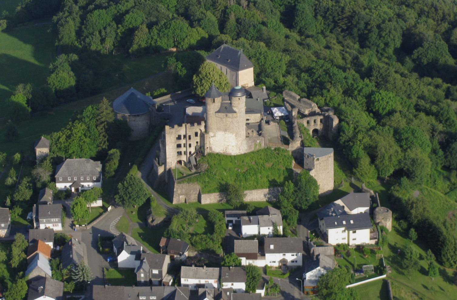
Greifenstein Castle (german: Burg Greifenstein) lies in the eponymous village of Greifenstein in the county of Lahn-Dill-Kreis in Middle Hesse, Germany. It is a geo point in the national geopark of Westerwald-Lahn-Taunus. Location The hill castle stands on a hill in the Dill Westerwald and has a good view over the Dill valley. At above sea level (NN) it is the highest castle in the county of Lahn-Dill. The castle is a highly visible landmark. It is signed from the A 45 motorway. History The hill castle was first recorded in 1160. In 1298 it was destroyed by the counts of Nassau and Solms, as was Lichtenstein, which was not rebuilt. In 1315 it was enfeoffed by the House of Habsburg (Albert I had purchased the castle from Kraft of Greifenstein) to the Counts of Nassau.http://regesten.regesta-imperii.de/regshow.php?pk=44588&bandanzeige= After having several owners, it had become dilapidated by 1676 and was then converted into a Baroque '' schloss'' by William Maurice ... [...More Info...] [...Related Items...] OR: [Wikipedia] [Google] [Baidu] |
Sinn (Hesse)
Sinn is a municipality in Middle Hesse, Germany, in the Lahn-Dill-Kreis. Geography Location Sinn lies at a height of above sea level at the foot of the Westerwald range, south of Herborn in the Dill valley. Edingen Edingen lies on the Dill valley's west side on the slopes of the Westerwald range below the Greifenstein ruins and the like-named constituent community in the community of Greifenstein. Neighbouring communities Sinn borders in the northeast on the community of Mittenaar, in the east on the community of Ehringshausen, in the south on the community of Greifenstein and in the northwest on the town of Herborn (all in the Lahn-Dill-Kreis). Constituent communities The community consists of the following centres: * Edingen * Fleisbach * Sinn History The Dill valley's fertile slopes and dales were settled quite early on. Archaeological finds in the countryside around Edingen range through all epochs and have led to the conclusion that the area has been permanently set ... [...More Info...] [...Related Items...] OR: [Wikipedia] [Google] [Baidu] |
Sankt Andrä-Wördern
Sankt Andrä-Wördern is a municipality in the district of Tulln Tulln an der Donau () is a historic town in the Austrian state of Lower Austria, the administrative seat of Tulln District. Because of its abundance of parks and gardens, Tulln is often referred to as ''Blumenstadt'' ("City of Flowers"), and "The C ... in the Austrian state of Lower Austria. Population Notable people * Kurt Waldheim (1918–2007), Austrian president and the fourth Secretary-General of the United Nations (1972–1981) References External links www.staw.at- town website Cities and towns in Tulln District {{LowerAustria-geo-stub ... [...More Info...] [...Related Items...] OR: [Wikipedia] [Google] [Baidu] |
Mengerskirchen
Mengerskirchen is a municipality in Limburg-Weilburg district in Hesse, Germany. Geography Neighbouring communities Mengerskirchen borders in the north on the community of Greifenstein ( Lahn-Dill-Kreis), in the east on the community of Löhnberg, in the south on the communities of Merenberg and Waldbrunn (all three in Limburg-Weilburg), and in the west on the communities of Neunkirchen, Elsoff and Oberrod (all three in the Westerwaldkreis in Rhineland-Palatinate). Constituent communities Mengerskirchen’s '' Ortsteile'' are, Dillhausen, Mengerskirchen, Probbach, Waldernbach and Winkels. The community administration’s seat is the market centre of Mengerskirchen. Each of the constituent communities is represented on a municipal advisory board (''Ortsbeirat'') by a community head (''Ortsvorsteher''). Tourism Sightseeing * ''Burg Mengerskirchen'' (castle) * Acidic mineral springs in Dillhausen and Probbach * Maienburg (Eigenberg) castle ruins near Winkels * Winkels chur ... [...More Info...] [...Related Items...] OR: [Wikipedia] [Google] [Baidu] |
Lahn-Dill-Kreis
Lahn-Dill is a ''Kreis'' (district) in the west of Hesse, Germany. Neighboring districts are Siegen-Wittgenstein, Marburg-Biedenkopf, Gießen, Wetteraukreis, Hochtaunuskreis, Limburg-Weilburg, Westerwaldkreis. History The southern district belonged to the Princes of Solms-Braunfels and the Free Imperial City of Wetzlar. The latter had to give up its imperial freedom in 1803 as a result of the Imperial Deputation, then as the county of Wetzlar, in favor of the newly created Grand Duchy of Frankfurt of the prince primate (in the old empire Reichserzkanzler) Karl Theodor von Dalberg. The former Solmsian territories came to the Duchy of Nassau in 1806 and in 1815 also to Prussia in an exchange. In 1816, the Prussian districts of Wetzlar and Braunfels were created, which were united in 1822 to form the district of Wetzlar. The district belonged to the Prussian Rhine Province as an exclave until 1932. Since the Middle Ages, the northern part of the district belonged to the principalit ... [...More Info...] [...Related Items...] OR: [Wikipedia] [Google] [Baidu] |
Löhnberg
Löhnberg is a municipality north of Weilburg in Limburg-Weilburg district in Hesse, Germany. Geography Location Löhnberg lies between Wetzlar and the district seat of Limburg an der Lahn. Neighbouring communities Löhnberg borders in the north on the community of Greifenstein, in the east on the towns of Leun and Braunfels (all three in the Lahn-Dill-Kreis), in the south on the town of Weilburg, and in the west on the communities of Merenberg and Mengerskirchen (all three in Limburg-Weilburg). Constituent communities Löhnberg's '' Ortsteile'' are Löhnberg (administrative seat), Niedershausen, Obershausen and Selters. History All three constituent communities had their first documentary mention in the late 13th or early 14th century, although in Selters's case it is rather unclear as the village has the same name as both Selters in Rhineland-Palatinate and Selters in the Taunus. A document from 1317, however, can unequivocally be said to refer to Sel ... [...More Info...] [...Related Items...] OR: [Wikipedia] [Google] [Baidu] |
Leun
Leun is a small town in the Lahn-Dill-Kreis in Hesse, Germany. Geography Location Leun lies some 10 km west of Wetzlar between the foothills of the northern Taunus and the Westerwald in the Lahn valley, at a height of 150 to 330 m above sea level. Neighbouring communities Leun borders in the north on the communities of Greifenstein and Ehringshausen, in the east on the town of Solms, in the south on the town of Braunfels (all in the Lahn-Dill-Kreis) and in the west on the community of Löhnberg (Limburg-Weilburg). Constituent communities The town consists of the five centres of Biskirchen, Bissenberg, Lahnbahnhof, Leun and Stockhausen. History Leun had its first documentary mention in 771. Building a stone bridge in the late 15th century and being granted market rights helped the village's economic growth, which in 1664 resulted in town rights being granted. As part of Hesse's municipal reform, the new, bigger town of Leun came into being when the main town of Leun a ... [...More Info...] [...Related Items...] OR: [Wikipedia] [Google] [Baidu] |
Herborn (Hesse)
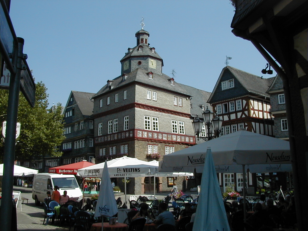
Herborn () is a historic town on the Dill in the Lahn-Dill district of Hesse in Germany. Before World War I, it was granted its own title as ''Nassauisches Rothenburg''. The symbol or mascot of this town is a bear. Scenic attractions include its half-timbered houses; Herborn is located on the German Timber-Frame Road. Herborn hosted the 26th ''Hessentag'' state festival in 1986, and the 56th Hessentag in 2016. Geography The town's coordinates are . It has an area of 64 km² (24 mi²), of which 28 km² (11 mi²) is forest. Herborn is connected by the A45 motorway ( E40/ E41) with Siegen, Wetzlar, and Gießen. Neighbouring communities Herborn is bordered on the north by the town of Dillenburg, on the northeast by the community of Siegbach, on the east by the community of Mittenaar, on the southeast by the community of Sinn, on the south by the community of Greifenstein, and on the west by the communities of Driedorf and Breitscheid (all in the Lahn-Dill-Kre ... [...More Info...] [...Related Items...] OR: [Wikipedia] [Google] [Baidu] |
Driedorf
Driedorf is a municipality in the Lahn-Dill-Kreis in Hesse, Germany. Geography Location Driedorf lies from 416 to 642 m above sea level on a tableland in the high Westerwald. Mademühlen Mademühlen has about 1,000 inhabitants and lies in the "Hessischer Westerwald" protected area and in the European protected area network Natura 2000. It is on the upper reaches of the Rehbach, between two reservoirs. Münchhausen Münchhausen is the first village on the Ulmbach and is blessed with extensive woodlands, which afforded prosperity in earlier times. Neighbouring communities Driedorf borders in the north on the community of Breitscheid, in the east on the town of Herborn, in the south on the community of Greifenstein (all in the Lahn-Dill-Kreis), and in the west on the communities of Oberrod, Rehe, Homberg, Waigandshain, Nister-Möhrendorf and Willingen (all in the Westerwaldkreis in Rhineland-Palatinate). Constituent communities Besides the namesake centre, there are eight ... [...More Info...] [...Related Items...] OR: [Wikipedia] [Google] [Baidu] |
Westerwald
The Westerwald (; literally 'Western forest') is a low mountain range on the right bank of the river Rhine in the German federal states of Rhineland-Palatinate, Hesse and North Rhine-Westphalia. It is a part of the Rhenish Massif ( or Rhenish Slate Mountains). Its highest elevation, at 657 m above sea level, is the Fuchskaute in the High Westerwald. Tourist attractions include the (394 metres), site of some Celtic ruins from La Tène times (5th to 1st century BC), found in the community of the same name, and Limburg an der Lahn, a town with a mediaeval centre. The geologically old, heavily eroded range of the Westerwald is in its northern parts overlaid by a volcanic upland made of Neogene basalt layers. It covers an area of some , and therefore roughly , making the Westerwald one of Germany's biggest mountain ranges by area. In areas of subsidence, it has in its flatter western part (Lower Westerwald) the characteristics of rolling hills. Typical for the economy of th ... [...More Info...] [...Related Items...] OR: [Wikipedia] [Google] [Baidu] |
East Prussia
East Prussia ; german: Ostpreißen, label= Low Prussian; pl, Prusy Wschodnie; lt, Rytų Prūsija was a province of the Kingdom of Prussia from 1773 to 1829 and again from 1878 (with the Kingdom itself being part of the German Empire from 1871); following World War I it formed part of the Weimar Republic's Free State of Prussia, until 1945. Its capital city was Königsberg (present-day Kaliningrad). East Prussia was the main part of the region of Prussia along the southeastern Baltic Coast. The bulk of the ancestral lands of the Baltic Old Prussians were enclosed within East Prussia. During the 13th century, the native Prussians were conquered by the crusading Teutonic Knights. After the conquest the indigenous Balts were gradually converted to Christianity. Because of Germanization and colonisation over the following centuries, Germans became the dominant ethnic group, while Masurians and Lithuanians formed minorities. From the 13th century, East Prussia was pa ... [...More Info...] [...Related Items...] OR: [Wikipedia] [Google] [Baidu] |
Ruhr Area
The Ruhr ( ; german: Ruhrgebiet , also ''Ruhrpott'' ), also referred to as the Ruhr area, sometimes Ruhr district, Ruhr region, or Ruhr valley, is a polycentric urban area in North Rhine-Westphalia, Germany. With a population density of 2,800/km2 and a population of over 5 million (2017), it is the largest urban area in Germany. It consists of several large cities bordered by the rivers Ruhr to the south, Rhine to the west, and Lippe to the north. In the southwest it borders the Bergisches Land. It is considered part of the larger Rhine-Ruhr metropolitan region of more than 10 million people, which is the third largest in Europe, behind only London and Paris. The Ruhr cities are, from west to east: Duisburg, Oberhausen, Bottrop, Mülheim an der Ruhr, Essen, Gelsenkirchen, Bochum, Herne, Hagen, Dortmund, Lünen, Bergkamen, Hamm and the districts of Wesel, Recklinghausen, Unna and Ennepe-Ruhr-Kreis. The most populous cities are Dortmund (with a population of approx ... [...More Info...] [...Related Items...] OR: [Wikipedia] [Google] [Baidu] |


