|
Great Chesterford
Great Chesterford is a village and civil parish in the Uttlesford district of Essex, England. The village is north from Bishop's Stortford, south from Cambridge and about northwest from the city and Essex county town of Chelmsford. The Icknield Way Path passes through the village on its route between Ivinghoe Beacon in Buckinghamshire and Knettishall Heath in Suffolk. The Icknield Way Trail, a route for walkers, horse riders and cyclists also passes through. History Great Chesterford is an ancient village with many listed buildings situated on the banks of the River Cam, or Granta, on the boundary of Essex and Cambridgeshire. The land around Great Chesterford has been inhabited for centuries, and there have been many archaeological finds e.g. Bronze Age beakers, Belgic pottery and jewellery, and many Roman artefacts which can be found in both Saffron Walden and Cambridge museums. In the 1st century AD, a Romano-British civil settlement was established near the river, ... [...More Info...] [...Related Items...] OR: [Wikipedia] [Google] [Baidu] |
Uttlesford
Uttlesford is a local government district in Essex, England. Its council is based in the market town of Saffron Walden. At the 2011 Census, the population of the district was 79,443. Other notable settlements include Great Dunmow, Elmdon, Stebbing, Stansted Mountfitchet, Thaxted, Debden, Little Chesterford and Felstead among other settlements. History Its name is derived from its location within the ancient Hundred (county subdivision), hundred of Uttlesford,Open Domesday: Hundred of Uttlesford. Accessed 6 January 2022. usually spelled ''Vdelesford'' Open Domesday: Saffron Walden. Accessed 6 January 2022. or ''Wdelesford'' [...More Info...] [...Related Items...] OR: [Wikipedia] [Google] [Baidu] |
Saffron Walden
Saffron Walden is a market town in the Uttlesford district of Essex, England, north of Bishop's Stortford, south of Cambridge and north of London. It retains a rural appearance and some buildings of the medieval period. The population was 15,504 at the 2011 census. History Archaeological evidence suggests continuous settlement on or near the site of Saffron Walden from at least the Neolithic British Isles, Neolithic period. It is believed that a small Romano-British culture, Romano-British settlement and fort – possibly in the area round Abbey Lane – existed as an outpost of the much larger settlement of Great Chesterford, Cestreforda to the north. After the Norman conquest of England, Norman invasion of 1066, a stone church was built. Walden Castle, dating from about 1140, may have been built on pre-existing fortifications. A priory, Walden Abbey, was founded under the patronage of Geoffrey de Mandeville, 1st Earl of Essex about 1136, on the site of what is now Audley En ... [...More Info...] [...Related Items...] OR: [Wikipedia] [Google] [Baidu] |
The Hundred Parishes
The Hundred Parishes is an area of the East of England with no formal recognition or status, albeit that the concept has the blessing of county and district authorities. It encompasses around 450 square miles (1,100 square kilometres) of northwest Essex, northeast Hertfordshire and southern Cambridgeshire. The area comprises just over 100 administrative parishes, hence its name. It contains over 6,000 listed buildings and many conservation areas, village greens, ancient hedgerows, protected features and a historical pattern of small rural settlements in close proximity to one another. Origins The idea of recognising the area for its special heritage characteristics was originally conceived by local historian and author David Heathcote. A steering group of local historians, conservationists and a local authority representative, spearheaded by the Essex branch of the Campaign to Protect Rural England ( CPRE), progressed the idea and defined a boundary. The name arose in respons ... [...More Info...] [...Related Items...] OR: [Wikipedia] [Google] [Baidu] |
Germaine Greer
Germaine Greer (; born 29 January 1939) is an Australian writer and public intellectual, regarded as one of the major voices of the radical feminist movement in the latter half of the 20th century. Specializing in English and women's literature, she has held academic positions in England at the University of Warwick and Newnham College, Cambridge, and in the United States at the University of Tulsa. Based in the United Kingdom since 1964, she has divided her time since the 1990s between Queensland, Australia, and her home in Essex, England. Greer's ideas have created controversy ever since her first book, ''The Female Eunuch'' (1970), made her a household name. An international bestseller and a watershed text in the feminist movement, it offered a systematic deconstruction of ideas such as womanhood and femininity, arguing that women were forced to assume submissive roles in society to fulfil male fantasies of what being a woman entailed. Greer's subsequent work has focused o ... [...More Info...] [...Related Items...] OR: [Wikipedia] [Google] [Baidu] |
Norwich
Norwich () is a cathedral city and district of Norfolk, England, of which it is the county town. Norwich is by the River Wensum, about north-east of London, north of Ipswich and east of Peterborough. As the seat of the See of Norwich, with one of the country's largest medieval cathedrals, it is the largest settlement and has the largest urban area in East Anglia. The population of the Norwich City Council local authority area was estimated to be 144,000 in 2021, which was an increase from 143,135 in 2019. The wider built-up area had a population of 213,166 in 2019. Heritage and status Norwich claims to be the most complete medieval city in the United Kingdom. It includes cobbled streets such as Elm Hill, Timber Hill and Tombland; ancient buildings such as St Andrew's Hall; half-timbered houses such as Dragon Hall, The Guildhall and Strangers' Hall; the Art Nouveau of the 1899 Royal Arcade; many medieval lanes; and the winding River Wensum that flows through the city ... [...More Info...] [...Related Items...] OR: [Wikipedia] [Google] [Baidu] |
A11 Road (England)
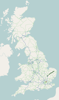
The A11 is a major trunk road in England. It runs roughly north east from London to Norwich, Norfolk, although after the M11 opened in the 1970s and then the A12 extension in 1999, a lengthy section has been downgraded between the suburbs of east London and the north-west corner of the county of Essex. It also multiplexes/overlaps with the A14 on the Newmarket bypass. Route City of London All this part has been declassified and is now a minor road. Thus the A11 now starts at Aldgate, just inside the eastern boundary of the City of London. The first stretch is Whitechapel High Street, east of the junction with Mansell Street. In a complex reworking of the roads since the days of the Aldgate gyratory system, it is two-way, but the east-bound section is part of the ring-road that retained a one-way system south of this junction, but the west-bound section is for local access and you have to U-turn to avoid entering the congestion charging zone. Tower Hamlets East of Aldgate ... [...More Info...] [...Related Items...] OR: [Wikipedia] [Google] [Baidu] |
M11 Motorway
The M11 is a motorway that runs north from the North Circular Road (A406) in South Woodford to the A14, northwest of Cambridge, England. Originally proposed as a trunk road as early as 1915, various plans were considered throughout the 1960s, with final construction being undertaken between 1975 and 1980. The motorway was opened in stages, with the first stage between junctions 7 and 8 opening in June 1975, and the completed motorway becoming fully operational in February 1980. Running from Woodford to Girton, the motorway provides direct access to Harlow, Cambridge and since 2002, greatly improved access to London Stansted Airport. Route The M11 starts in South Woodford in northeast London, just north of Redbridge Roundabout, crosses the North Circular (A406) at junction 4, it then heads NNE, passing east of Loughton and Theydon Bois as well as Epping Forest, meeting the M25 motorway at junction 6, and then veering approximately north, passing to the east of Harlow. The M1 ... [...More Info...] [...Related Items...] OR: [Wikipedia] [Google] [Baidu] |
Stagecoach East
Stagecoach East is the divisional name for the bus operations of the Stagecoach Group in eastern England. History Under the control of the National Bus Company, ''Cambus Ltd.'' was set up when the Eastern Counties Omnibus Company was split in preparation for privatisation. The company was incorporated on 8 June 1984; it took over Eastern Counties' bus and National Express coach operations from garages in Cambridgeshire and parts of Suffolk (Newmarket and Haverhill) on 9 September 1984. On 5 December 1986, Cambus was sold to its management team, off-the-shelf company Minuteflush Ltd. being used for this purpose; Minuteflush Ltd. was renamed Cambus Holdings Ltd. In September 1989, Cambus's Peterborough operations were split off to form ''The Viscount Bus and Coach Company Ltd.'', while in May 1990 Cambus Holdings acquired most of the bus and coach operations of Cambridge-based Premier Travel Services, the exception being the Cambridge–London Airports coach services, which rem ... [...More Info...] [...Related Items...] OR: [Wikipedia] [Google] [Baidu] |
Francis Thompson (architect)
Francis Thompson (25 July 1808–23 April 1895) was an English architect particularly well known for his railway work. Early life Thompson was born in Woodbridge in Suffolk, England, the second of seven children of George Thompson and his wife Elizabeth (née Miles). George Thompson was a builder and the Suffolk county surveyor, descended from a family of farmers in the nearby village of Bredfield. Francis' grandfather Jacob was also a builder and two of his uncles were architects. Thompson attended Woodbridge Grammar School and his family's background instilled him with an interest in architecture. He married Anna Maria Watson on 17 May 1830 in Woodbridge church. The couple soon emigrated to Montreal in British North America (now in Quebec, Canada). Their son, Francis Jacob, was born the following year. Anna died of cholera in 1832 as a result of the second cholera pandemic, a global outbreak which killed 4,000 people in Montreal. Thompson designed multiple houses, commerc ... [...More Info...] [...Related Items...] OR: [Wikipedia] [Google] [Baidu] |
Sancton Wood
Sancton Wood (27 April 1814 – 18 April 1886) was an English architect and surveyor, known for his work on railway buildings. Life and family Sancton Wood was born on 27 April 1814 in Nursery Place, Hackney Terrace, Hackney, London. He was the son of John Wood and Harriet Russell. He had 5 sisters. Wood's birth was registered in the Protestant dissenters’ birth registry. His mother was a niece of the painter, Richard Smirke. His paternal family were cotton merchants originally from Cumberland. He was named Sancton after his paternal uncle by marriage, Philip Sancton, a London merchant. He attended a private school in Devon, and later a school run by T. W. Hill at Hazelwood, Birmingham. On 11 March 1839, Wood married Elizabeth Sarah Simson (1810–1878), at Dedham, Essex. The couple had two sons, Herbert Sancton Wood (1844–1883) and William Winder Wood (1846–1876). The family moved to 11 Putney Hill, London in 1850, a house which Wood designed. He died there on 18 Apr ... [...More Info...] [...Related Items...] OR: [Wikipedia] [Google] [Baidu] |
Great Chesterford Railway Station
Great Chesterford railway station is on the West Anglia Main Line serving the village of Great Chesterford in Essex, England. It is down the line from London Liverpool Street and is situated between and stations. Its three-letter station code is GRC. The station and all trains calling are operated by Greater Anglia. The station was once the point where the Newmarket Railway left the London to main line. This route was authorised in 1846, opened on 3 January 1848 for goods and to passengers three days later. The Newmarket branch was an early victim of poor finance leading to closure: it was temporarily closed on 30 June 1850 and reopened on 9 September 1850, but the section between Great Chesterford and was closed permanently on 9 October 1851 with the opening of the direct line between Six Mile Bottom and Cambridge. The next station to the north of Great Chesterford was . Services All services at Great Chesterford are operated by Greater Anglia using EMUs. The typical ... [...More Info...] [...Related Items...] OR: [Wikipedia] [Google] [Baidu] |
Wards And Electoral Divisions Of The United Kingdom
The wards and electoral divisions in the United Kingdom are electoral districts at sub-national level, represented by one or more councillors. The ward is the primary unit of English electoral geography for civil parishes and borough and district councils, the electoral ward is the unit used by Welsh principal councils, while the electoral division is the unit used by English county councils and some unitary authorities. Each ward/division has an average electorate of about 5,500 people, but ward population counts can vary substantially. As of 2021 there are 8,694 electoral wards/divisions in the UK. England The London boroughs, metropolitan boroughs and non-metropolitan districts (including most unitary authorities) are divided into wards for local elections. However, county council elections (as well as those for several unitary councils which were formerly county councils, such as the Isle of Wight and Shropshire Councils) instead use the term ''electoral division''. In s ... [...More Info...] [...Related Items...] OR: [Wikipedia] [Google] [Baidu] |


