|
Geography Of Korea
Korea comprises the Korean Peninsula (the mainland) and 3,960 nearby islands. The peninsula is located in Northeast Asia, between China and Japan. To the northwest, the Amnok River (Yalu River) separates Korea from China and to the northeast, the Duman River (Tumen River) separates Korea from China and Russia. The Yellow Sea lies to the west, the East China Sea and Korea Strait to the south, and the Sea of Japan to the east. Notable islands include Jeju Island (Jejudo), Ulleungdo, Ulleung Island (Ulleungdo), and the Liancourt Rocks. At 223,179 km2, the area of Korea is similar to the area of the United Kingdom (244,100 km2) or the U.S. state of Minnesota (225,171 km2). Excluding the islands, the area of the Korean Peninsula is 220,847 km2. The peninsula measures approx. 1,100 km from north to south and 300 km from east to west. The southern and western parts of the peninsula have well-developed plains, while the eastern and northern parts are mountainous. The highest mountain ... [...More Info...] [...Related Items...] OR: [Wikipedia] [Google] [Baidu] |
Daedongyeojido 1860
Daedongyeojido (also Daedong yeojido, ko, 대동여지도, 大東輿地圖, lit. "The Great Map of the East Land") is a large scale map of Korea produced by Joseon dynasty cartographer and geologist Kim Jeong-ho in 1861. A second edition was printed in 1864. One source describes it as the "oldest map in Korea". Daedongyeojido is considered very advanced for its time, and marks the zenith of pre-modern Korean cartography. Description The map consists of 22 separate, foldable booklets, each covering approximately (north-south) by (east–west). Combined, they form a map of Korea that is wide and long. The scale of the map is 1:162,000. The map was printed from 70 basswood woodblocks, engraved on both sides. The techniques to create the map have been described as a hybrid of Korean and Western methods. The map is praised for precise delineations of mountain ridges, waterways, and transportation routes. It also has markings for settlements, including villages, as well as notab ... [...More Info...] [...Related Items...] OR: [Wikipedia] [Google] [Baidu] |
Incheon
Incheon (; ; or Inch'ŏn; literally "kind river"), formerly Jemulpo or Chemulp'o (제물포) until the period after 1910, officially the Incheon Metropolitan City (인천광역시, 仁川廣域市), is a city located in northwestern South Korea, bordering Seoul and Gyeonggi to the east. Inhabited since the Neolithic, Incheon was home to just 4,700 people when it became an international port in 1883. Today, about 3 million people live in the city, making it South Korea's third-most-populous city after Seoul and Busan. The city's growth has been assured in modern times with the development of its port due to its natural advantages as a coastal city and its proximity to the South Korean capital. It is part of the Seoul Capital Area, along with Seoul itself and Gyeonggi Province, forming the world's fourth-largest metropolitan area by population. Incheon has since led the economic development of South Korea by opening its port to the outside world, ushering in the modernization o ... [...More Info...] [...Related Items...] OR: [Wikipedia] [Google] [Baidu] |
Felsic
In geology, felsic is a modifier describing igneous rocks that are relatively rich in elements that form feldspar and quartz.Marshak, Stephen, 2009, ''Essentials of Geology,'' W. W. Norton & Company, 3rd ed. It is contrasted with mafic rocks, which are relatively richer in magnesium and iron. Felsic refers to silicate minerals, magma, and rocks which are enriched in the lighter elements such as silicon, oxygen, aluminium, sodium, and potassium. Felsic magma or lava is higher in viscosity than mafic magma/lava. Felsic rocks are usually light in color and have specific gravities less than 3. The most common felsic rock is granite. Common felsic minerals include quartz, muscovite, orthoclase, and the sodium-rich plagioclase feldspars (albite-rich). Terminology In modern usage, the term ''acid rock'', although sometimes used as a synonym, normally now refers specifically to a high-silica-content (greater than 63% SiO2 by weight) volcanic rock, such as rhyolite. Older, broader usage ... [...More Info...] [...Related Items...] OR: [Wikipedia] [Google] [Baidu] |
Mount Halla
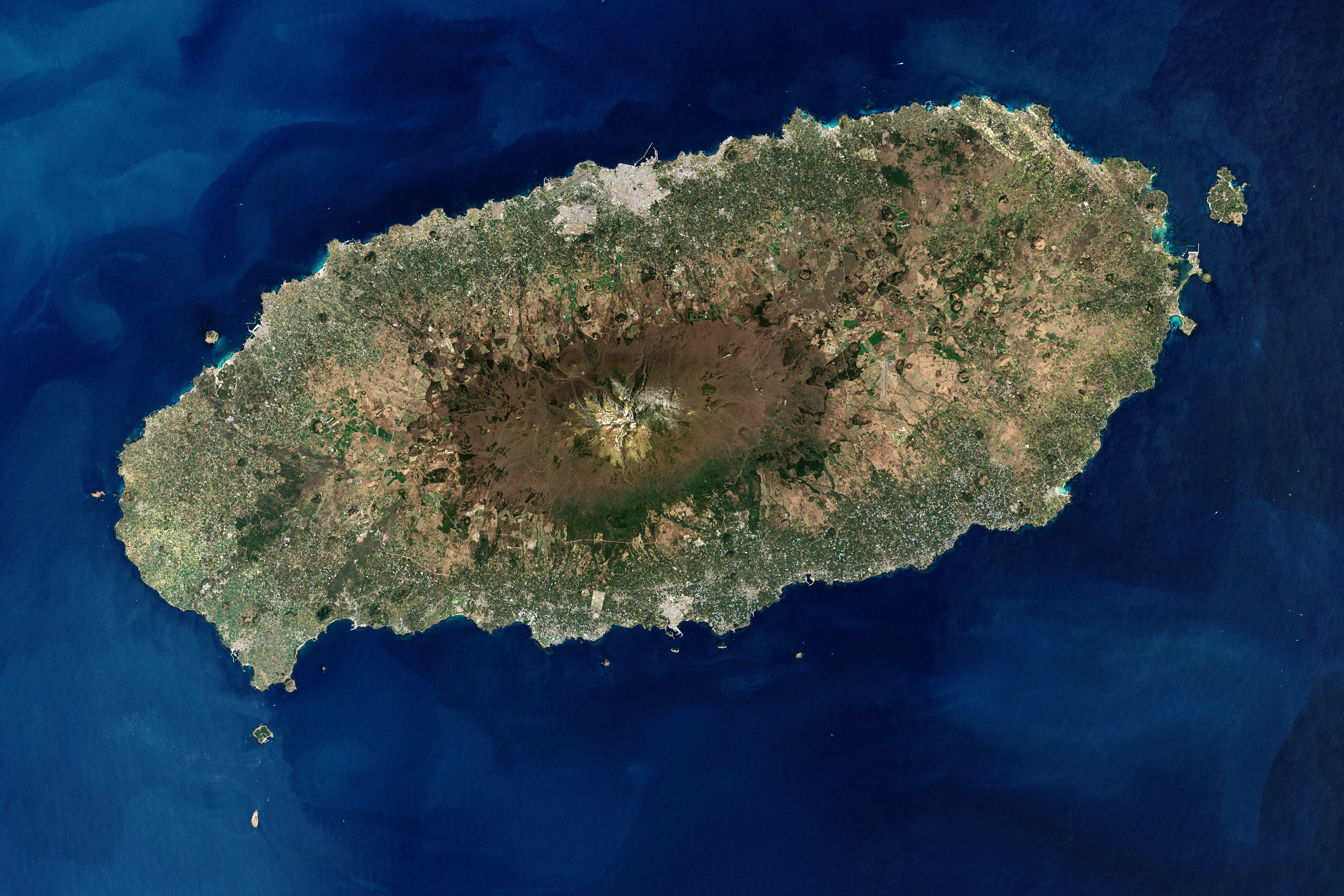
Hallasan is a shield volcano on Jeju Island in South Korea; it is the highest point of South Korea and the second-highest mountain in Korea overall, after Paektu Mountain. The area around the mountain is a designated national park, the Hallasan National Park (, ). Hallasan is commonly considered to be one of the three main mountains of South Korea, along with Jirisan and Seoraksan. Names Hallasan is the highest mountain in South Korea and is worshipped by people as they believe that gods and spirits live on the mountain. Alternate English names for the mountain include Hanla Mountain or Mount Halla and older English sources refer to the peak as Mount Auckland. Hallasan is written in Hangul as if it were ''Hanrasan'' (); however, it is still pronounced as ''Hallasan''. In the past, Hallasan has been known by numerous other names in Korean including ''Buak'' (/), ''Wonsan'' (/), ''Jinsan'' (/), ''Seonsan'' (/), ''Dumuak'' (/), ''Burasan'' (/), ''Yeongjusan'' (/), and ''Hyeolman ... [...More Info...] [...Related Items...] OR: [Wikipedia] [Google] [Baidu] |
Mount Jiri
Jirisan is a mountain located in the southern region of South Korea. It is the second-tallest mountain in South Korea after Jeju Island's Hallasan, and the tallest mountain in mainland South Korea. The 1915m-high mountain is located in Jirisan National Park. The park spans three provinces (North, South Jeolla and South Gyeongsang) and is the largest in South Korea. The largest proportion of the national park is in the province of South Gyeongsang. The highest peak of the mountain, Cheonwangbong is also located in this province. Another well-known peak is Samshin-bong (Three Spirits Peak). Jirisan is at the southern end of the Sobaek and Baekdudaegan mountain ranges, the "spine" of the Korean Peninsula incorporating the Sobaek mountain range and most of the Taebaek mountain range. There are seven major Buddhist temples on Jirisan. Hwaeomsa is the largest and best-known temple among these. It contains several national treasures, mostly stone artworks from about 600–900 ... [...More Info...] [...Related Items...] OR: [Wikipedia] [Google] [Baidu] |
Taebaeksan
Taebaeksan, also known as Mount Taebaeksan or Mount Taebaek, is a South Korean mountain with several important peaks of the Taebaek mountain range (in Western-style geography), or the Taebaek Jeongmaek Range (in Korean-style geography). It is an important mountain in the Baekdu-daegan Mountain-system Baekdudaegan, the point where it turns west after running along Korea's east coast for a long distance. Its territory stretches from the city of Taebaek in Yeongwol-gun County, Gangwon-do Province to Bonghwa-gun County, Gyeongsangbuk-do Province, and it was designated South Korea's 22nd national park on 22 August 2016. It has an elevation of . Attractions Manggyeongsa Temple in Hyeol-dong Taebaek, Yeongwol-gun County, Gangwon-do Province at an elevation of 1,460 meters on Taebaeksan, is a temple built to enshrine the statue of the Bodhisattva of wisdom. It was built by Jajang, a Silla Dynasty monk. The "Dragon Spring" at the entrance of the temple is known as the highest spring ... [...More Info...] [...Related Items...] OR: [Wikipedia] [Google] [Baidu] |
Seoraksan
Seoraksan is the highest mountain in the Taebaek mountain range in the Gangwon Province (South Korea), Gangwon Province in eastern South Korea. It is located in a national park near the city of Sokcho. After the Hallasan volcano on Jeju-do, Jeju Island and Jirisan in the south, Seoraksan is the third highest mountain in South Korea. The ''Daechongbong Peak'' (대청봉) of Seoraksan reaches 1,708 meters (5,603 feet). The mountain is sometimes considered the backbone of South Korea. Geography Seoraksan is divided into Naeseorak (Inner Seorak), Oaeseorak (Outer Seorak), and Namseorak (South Seorak). Naeseorak (Inner Seorak) The area belonging to Inje-gun in the northwest and Daecheongbong Peak is called Naeseolak, Naeseorak features various valley views including Baekdam Valley, Gaya-dong Valley, Gugokdam Valley, Gugokdam Valley, 12 Seonnyeondang, Daeseung Falls and Yongajangseong Fortress. In addition to Cheonbul-dong Valley, it is easy to access Ulsan Rock, Gwongeumseong F ... [...More Info...] [...Related Items...] OR: [Wikipedia] [Google] [Baidu] |
Mount Kumgang
Mount Kumgang () or the Kumgang Mountains is a mountain massif, with a summit, peak, in Kangwon-do (North Korea), Kangwon-do, North Korea. It is located on the east coast of the country, in Mount Kumgang Tourist Region, formerly part of Kangwon-do (North Korea), Kangwŏn Province, and is part of the Taebaek mountain range which runs along the east of the Korean Peninsula. The mountain is about from the South Korean city of Sokcho in Gangwon-do (South Korea), Gangwon-do. Seasonal names Mount Kumgang has been known for its scenic beauty since History of Korea, ancient times and is the subject of many different works of art. Including its spring (season), spring name, ''Kŭmgangsan'' (, ), it has many different names for each season, but it is most widely known today in the Korean language as Kŭmgangsan. In summer it is called Pongraesan (봉래산, : ''the place where a Spirit dwells''); in autumn, Phung'aksan (풍악산, : ''hill of colored leaves'', or : ''great mountain of ... [...More Info...] [...Related Items...] OR: [Wikipedia] [Google] [Baidu] |
Sobaeksan
Sobaeksan (Sobaek Mountain) is a mountain of the Sobaek Mountains, in South Korea. It lies between Danyang County in the province of Chungcheongbuk-do and the city of Yeongju in the province of Gyeongsangbuk-do. It has an elevation of .Yu 2007, p.353. The Korea Astronomy and Space Science Institute operates an observatory on this mountain. See also * Sobaeksan National Park * List of mountains in Korea The following is a list of mountains in Korea: List of mountains in North Korea Pyeongyang * Taesongsan (대성산; ) – Chagang Province * Namsan (남산; ) – * Obongsan (오봉산; ) – North Pyongan Province * Myohyangsan (묘향� ... Notes References * {{coord, 36, 57, 36, N, 128, 29, 05, E, type:mountain_source:kolossus-kowiki, display=title Mountains of South Korea Mountains of North Chungcheong Province Mountains of North Gyeongsang Province Sobaek Mountains ... [...More Info...] [...Related Items...] OR: [Wikipedia] [Google] [Baidu] |
Baekdudaegan
The Baekdu-daegan is a mountain-system and watershed-crest-line which runs through almost all of the length of the Korean Peninsula, from Paektu Mountain (2,744m) in the north to the Cheonhwang-bong or "Heavenly Monarch Peak" of Jirisan (1,915m) in the south. It has 13 Jeongmaek or branch-ranges that begin on the mainline range and channel Korea's biggest rivers to the east, west and south seas. The Baekdu-daegan is important in traditional Korean geography and thought, a key aspect of Pungsujiri philosophy and practices. It is often referred to as the "spine" or "backbone" of the Korean Peninsula, and depicted in various historic and modern artworks including national maps. Under traditional Korean thought influenced by Daoism and Neo-Confucianism, Mt. Baekdu-san is regarded as the northern root-origin of the mountain-system, and conceived-of as the grand patriarch of all Korean mountains; while Jiri-san at the southern end is conceived-of as the grand matriarch of all Ko ... [...More Info...] [...Related Items...] OR: [Wikipedia] [Google] [Baidu] |
Orogeny
Orogeny is a mountain building process. An orogeny is an event that takes place at a convergent plate margin when plate motion compresses the margin. An ''orogenic belt'' or ''orogen'' develops as the compressed plate crumples and is uplifted to form one or more mountain ranges. This involves a series of geological processes collectively called orogenesis. These include both structural deformation of existing continental crust and the creation of new continental crust through volcanism. Magma rising in the orogen carries less dense material upwards while leaving more dense material behind, resulting in compositional differentiation of Earth's lithosphere ( crust and uppermost mantle). A synorogenic process or event is one that occurs during an orogeny. The word "orogeny" () comes from Ancient Greek (, , + , , ). Although it was used before him, the term was employed by the American geologist G. K. Gilbert in 1890 to describe the process of mountain-building as distinguished f ... [...More Info...] [...Related Items...] OR: [Wikipedia] [Google] [Baidu] |
Cenozoic
The Cenozoic ( ; ) is Earth's current geological era, representing the last 66million years of Earth's history. It is characterised by the dominance of mammals, birds and flowering plants, a cooling and drying climate, and the current configuration of continents. It is the latest of three geological eras since complex life evolved, preceded by the Mesozoic and Paleozoic. It started with the Cretaceous–Paleogene extinction event, when many species, including the non-avian dinosaurs, became extinct in an event attributed by most experts to the impact of a large asteroid or other celestial body, the Chicxulub impactor. The Cenozoic is also known as the Age of Mammals because the terrestrial animals that dominated both hemispheres were mammalsthe eutherians (placentals) in the northern hemisphere and the metatherians (marsupials, now mainly restricted to Australia) in the southern hemisphere. The extinction of many groups allowed mammals and birds to greatly diversify so that l ... [...More Info...] [...Related Items...] OR: [Wikipedia] [Google] [Baidu] |


%2C_1890.jpg)


