|
Gaps And Gores
Gaps and gores are portions of land areas that do not conform to boundaries found in cadastre and other land surveys based upon imprecise measurements and other ambiguities of metes and bounds. A gap, also known as a hiatus, occurs where the descriptions in deeds describing adjacent properties (unintentionally) overlook a space or "gap" between them. A gore occurs where descriptions in larger administrative boundaries (towns, counties) of adjacent jurisdictions or, large parcels, all fail to include some portion of land between them, forming an unclaimed, characteristically triangular "sliver" of land. Disputes often arise regarding the ownership of gaps and gores when they are discovered, usually when developers detect sufficient value in the local land. Local laws will determine whether they are considered abandoned or rather adhere to (or may be absorbed by) one adjacent parcel or another. For example, in Tennessee law, tax map boundaries can become property boundaries (not ... [...More Info...] [...Related Items...] OR: [Wikipedia] [Google] [Baidu] |
Cadastre
A cadastre or cadaster is a comprehensive recording of the real estate or real property's metes and bounds, metes-and-bounds of a country.Jo Henssen, ''Basic Principles of the Main Cadastral Systems in the World,'/ref> Often it is represented graphically in a cadastral map. In most countries, legal systems have developed around the original administrative systems and use the cadastre to define the dimensions and location of land parcels described in legal documentation. A land parcel or cadastral parcel is defined as "a continuous area, or more appropriately volume, that is identified by a unique set of homogeneous property rights". Cadastral surveys document the Boundary (real estate), boundaries of land ownership, by the production of documents, diagrams, sketches, plans (''plats'' in the US), charts, and maps. They were originally used to ensure reliable facts for land valuation and taxation. An example from early England is the Domesday Book in 1086. Napoleon established a ... [...More Info...] [...Related Items...] OR: [Wikipedia] [Google] [Baidu] |
Topographic Surveying And Mapping
In modern mapping, a topographic map or topographic sheet is a type of map characterized by large- scale detail and quantitative representation of relief features, usually using contour lines (connecting points of equal elevation), but historically using a variety of methods. Traditional definitions require a topographic map to show both natural and artificial features. A topographic survey is typically based upon a systematic observation and published as a map series, made up of two or more map sheets that combine to form the whole map. A topographic map series uses a common specification that includes the range of cartographic symbols employed, as well as a standard geodetic framework that defines the map projection, coordinate system, ellipsoid and geodetic datum. Official topographic maps also adopt a national grid referencing system. Natural Resources Canada provides this description of topographic maps: Other authors define topographic maps by contrasting them with anothe ... [...More Info...] [...Related Items...] OR: [Wikipedia] [Google] [Baidu] |
Metes And Bounds
Metes and bounds is a system or method of describing land, real property (in contrast to personal property) or real estate. The system has been used in England for many centuries and is still used there in the definition of general boundaries. The system is also used in the Canadian province of Ontario, and throughout Canada for the description of electoral districts. By custom, it was applied in the original Thirteen Colonies that became the United States and in many other land jurisdictions based on English common law, including Zimbabwe, South Africa, India and Bangladesh. While still in hand-me-down use, this system has been largely overtaken in the past few centuries by newer systems such as rectangular (government survey) and lot and block (recorded plat). Typically the system uses physical features of the local geography, along with directions and distances, to define and describe the boundaries of a parcel of land. The boundaries are described in a running prose style, work ... [...More Info...] [...Related Items...] OR: [Wikipedia] [Google] [Baidu] |
Hiatus
Hiatus may refer to: *Hiatus (anatomy), a natural fissure in a structure *Hiatus (stratigraphy), a discontinuity in the age of strata in stratigraphy *''Hiatus'', a genus of picture-winged flies with sole member species ''Hiatus fulvipes'' *Global warming hiatus, relating to trends in global temperatures as measured at earth's surface *Vowel hiatus, a sequence of two syllables with no consonant in the middle Film and television * "Hiatus" (''30 Rock''), first-season finale episode of ''30 Rock'' *"Hiatus", an episode of '' NCIS'' *Hiatus (television), a break of several weeks or more in television scheduling *Hiatus (production), a routine break of television and movie production in the latter half of December Music *Hiatus (band), a Belgian crustcore band *The Hiatus, a Japanese rock band *"Hiatus", a song from the Asking Alexandria album ''Stand Up and Scream ''Stand Up and Scream'' is the debut studio album by British rock band Asking Alexandria. It was released on 15 Sept ... [...More Info...] [...Related Items...] OR: [Wikipedia] [Google] [Baidu] |
Gore (surveying)
A gore is an irregular parcel of land, as small as a triangle of median in a street intersection or as large as an unincorporated area the size of a township. In old English law, a gore was a small, narrow strip of land. In modern land law and surveying a gore is a strip of land, usually triangular in shape, as might be left between surveys that do not close. In some northeastern U.S. states (mainly northern New England), a gore (sometimes a land grant or purchase) remains as an unincorporated area of a county that is not part of any town, has limited self-government, and may be unpopulated. History Historically, North American named gores were most often the result of errors when the land was first surveyed and Colonial era land patents and, later, towns were laid out. A gore would be created by conflicting surveys, resulting in two or more patentees claiming the same land, or lie in an area between two supposedly abutting towns but technically in neither. Surrounding towns ... [...More Info...] [...Related Items...] OR: [Wikipedia] [Google] [Baidu] |
Gore (segment)
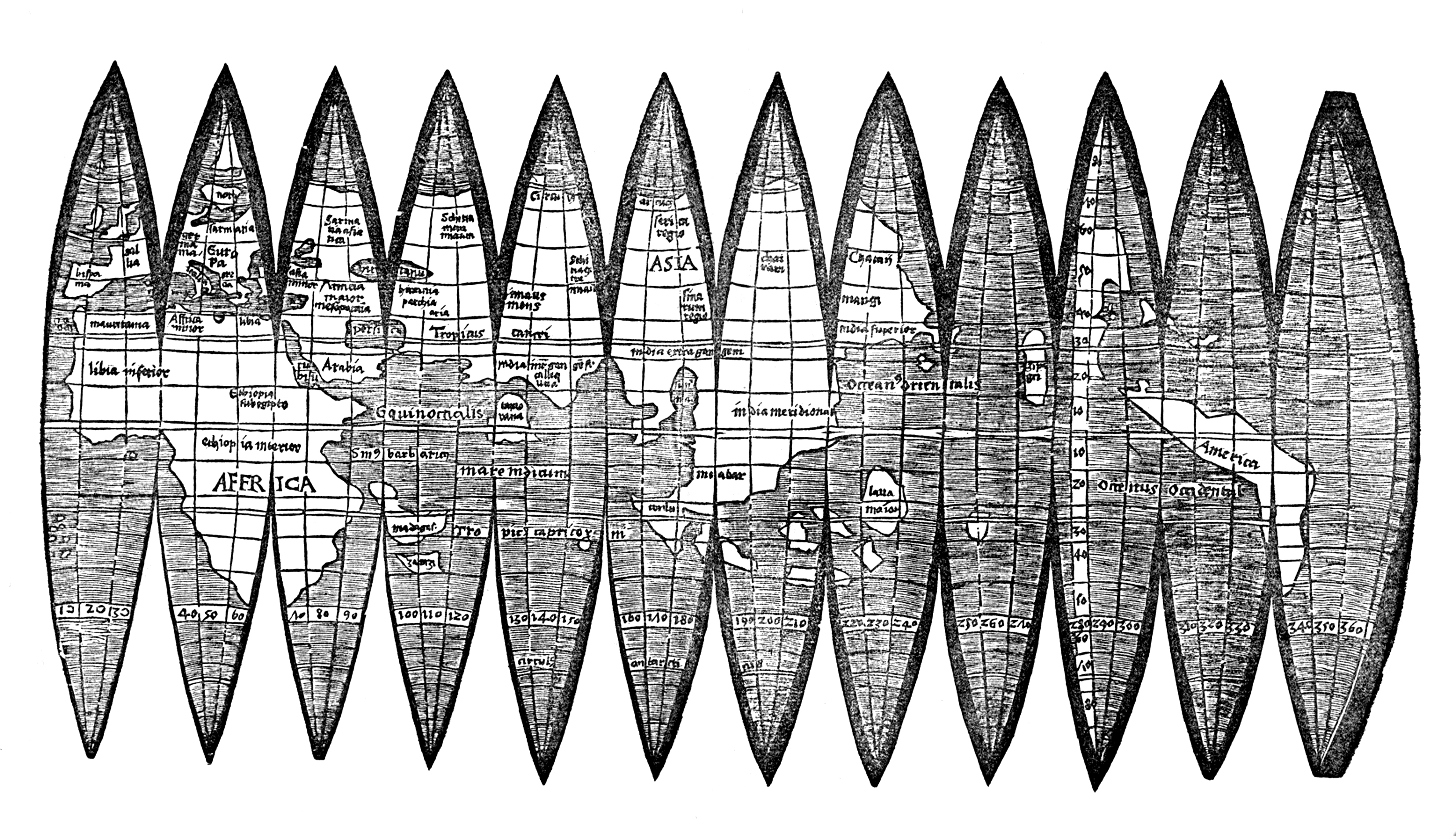
A gore is a sector of a curved surface or the curved surface that lies between two close lines of longitude on a globe and may be flattened to a plane surface with little distortion. The term has been extended to include similarly shaped pieces such as the panels of a hot-air balloon or parachute, or the triangular insert that allows extra movement in a garment (see Gore (fabrics)). Examples upleft, Red Hot air balloon * Globes of the Earth and the celestial sphere were first mass-produced by Johannes Schöner using a process of printing map details on 12 paper gores that were cut out then pasted to a sphere. This process is still often used. The gores are conveniently made to each have a width of 30 degrees of longitude matching the principal meridians from the South Pole and North Pole to the Equator. * Parachutes and hot air balloons are made from gores of lightweight material. The gores are cut from flat material and stitched together to create various shapes. * P ... [...More Info...] [...Related Items...] OR: [Wikipedia] [Google] [Baidu] |
Tennessee
Tennessee ( , ), officially the State of Tennessee, is a landlocked state in the Southeastern region of the United States. Tennessee is the 36th-largest by area and the 15th-most populous of the 50 states. It is bordered by Kentucky to the north, Virginia to the northeast, North Carolina to the east, Georgia, Alabama, and Mississippi to the south, Arkansas to the southwest, and Missouri to the northwest. Tennessee is geographically, culturally, and legally divided into three Grand Divisions of East, Middle, and West Tennessee. Nashville is the state's capital and largest city, and anchors its largest metropolitan area. Other major cities include Memphis, Knoxville, Chattanooga, and Clarksville. Tennessee's population as of the 2020 United States census is approximately 6.9 million. Tennessee is rooted in the Watauga Association, a 1772 frontier pact generally regarded as the first constitutional government west of the Appalachian Mountains. Its name derives from "Tanas ... [...More Info...] [...Related Items...] OR: [Wikipedia] [Google] [Baidu] |
Tax Map
A tax is a compulsory financial charge or some other type of levy imposed on a taxpayer (an individual or legal entity) by a governmental organization in order to fund government spending and various public expenditures (regional, local, or national), and tax compliance refers to policy actions and individual behaviour aimed at ensuring that taxpayers are paying the right amount of tax at the right time and securing the correct tax allowances and tax reliefs. The first known taxation took place in Ancient Egypt around 3000–2800 BC. A failure to pay in a timely manner ( non-compliance), along with evasion of or resistance to taxation, is punishable by law. Taxes consist of direct or indirect taxes and may be paid in money or as its labor equivalent. Most countries have a tax system in place, in order to pay for public, common societal, or agreed national needs and for the functions of government. Some levy a flat percentage rate of taxation on personal annual income, but mos ... [...More Info...] [...Related Items...] OR: [Wikipedia] [Google] [Baidu] |
Adverse Possession
Adverse possession, sometimes colloquially described as "squatter's rights", is a legal principle in the Common law, Anglo-American common law under which a person who does not have title (property), legal title to a piece of property—usually land (real property)—may acquire legal ownership based on continuous Possession (law), possession or occupation of the property without the permission (licence) of its legal owner. The possession by a person is not adverse if they are in possession as a Tenancy, tenant or licensee of the legal owner. In general, a property owner has the right to recover possession of their property from unauthorised possessors through legal action such as ejectment. However, in the English common law tradition, courts have long ruled that when someone occupies a piece of property without permission and the property's owner does not exercise their right to recover their property for a significant period of time, not only is the original owner prevented ... [...More Info...] [...Related Items...] OR: [Wikipedia] [Google] [Baidu] |
Gore (surveying)
A gore is an irregular parcel of land, as small as a triangle of median in a street intersection or as large as an unincorporated area the size of a township. In old English law, a gore was a small, narrow strip of land. In modern land law and surveying a gore is a strip of land, usually triangular in shape, as might be left between surveys that do not close. In some northeastern U.S. states (mainly northern New England), a gore (sometimes a land grant or purchase) remains as an unincorporated area of a county that is not part of any town, has limited self-government, and may be unpopulated. History Historically, North American named gores were most often the result of errors when the land was first surveyed and Colonial era land patents and, later, towns were laid out. A gore would be created by conflicting surveys, resulting in two or more patentees claiming the same land, or lie in an area between two supposedly abutting towns but technically in neither. Surrounding towns ... [...More Info...] [...Related Items...] OR: [Wikipedia] [Google] [Baidu] |
Gore (segment)
A gore is a sector of a curved surface or the curved surface that lies between two close lines of longitude on a globe and may be flattened to a plane surface with little distortion. The term has been extended to include similarly shaped pieces such as the panels of a hot-air balloon or parachute, or the triangular insert that allows extra movement in a garment (see Gore (fabrics)). Examples upleft, Red Hot air balloon * Globes of the Earth and the celestial sphere were first mass-produced by Johannes Schöner using a process of printing map details on 12 paper gores that were cut out then pasted to a sphere. This process is still often used. The gores are conveniently made to each have a width of 30 degrees of longitude matching the principal meridians from the South Pole and North Pole to the Equator. * Parachutes and hot air balloons are made from gores of lightweight material. The gores are cut from flat material and stitched together to create various shapes. * P ... [...More Info...] [...Related Items...] OR: [Wikipedia] [Google] [Baidu] |
Surveying
Surveying or land surveying is the technique, profession, art, and science of determining the terrestrial two-dimensional or three-dimensional positions of points and the distances and angles between them. A land surveying professional is called a land surveyor. These points are usually on the surface of the Earth, and they are often used to establish maps and boundaries for ownership, locations, such as the designed positions of structural components for construction or the surface location of subsurface features, or other purposes required by government or civil law, such as property sales. Surveyors work with elements of geodesy, geometry, trigonometry, regression analysis, physics, engineering, metrology, programming languages, and the law. They use equipment, such as total stations, robotic total stations, theodolites, GNSS receivers, retroreflectors, 3D scanners, LiDAR sensors, radios, inclinometer, handheld tablets, optical and digital levels, subsurface locators, d ... [...More Info...] [...Related Items...] OR: [Wikipedia] [Google] [Baidu] |


.png)


_crop.jpg)