|
Ganzee
Ganzee (also Gansee) is a former village in the Brokopondo District of Suriname. The village was home to Maroon people, Maroons of the Saramaka tribe, and located on the Suriname River. In 1965, the village was flooded after the construction of the Afobaka Dam. History The village was founded in the interior of Suriname by runaway slaves. From 1765 onwards, the Moravian Church embarked on missionary activities among the maroons. First the focus was on converting people. In 1850, the first school in the interior was opened in Ganzee. In 1919, the village had a population of about 500 people and was the capital of the Upper Suriname district. In 1931, a clinic was established in the village. In 1958, plans were developed to create the Afobaka Dam in order to provide electricity for the aluminium industry. The damming of the Suriname River would lead to the Brokopondo Reservoir, and flood the village of Ganzee. With an estimated 1,200 people, Ganzee was the biggest village in the ar ... [...More Info...] [...Related Items...] OR: [Wikipedia] [Google] [Baidu] |
Brokopondo Reservoir
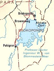
The Brokopondo Reservoir, officially named Professor Doctor Ingenieur W. J. van Blommestein Meer, and also called the Brokopondostuwmeer, is a large reservoir in Suriname. It is named after the Surakarta-born Dutch hydrological engineer Willem Johan van Blommestein. With a surface area of approximately , depending on the current water level, it is one of the largest reservoirs in the world, covering nearly one percent of the country. History The reservoir was created by constructing Afobaka Dam across the Suriname River between 1961 and 1964. The dam spanning the river is tall, and is built near the small town of Afobaka. Contrary to the reservoir's long official name, it was quickly rechristened ''Brokopondomeer'' by Dutch-speaking locals, after the town of Brokopondo further downstream from where the dam was constructed. The length of the dam, including secondary dams along the margins of the reservoir, is . The watershed which feeds the reservoir is in area. The reser ... [...More Info...] [...Related Items...] OR: [Wikipedia] [Google] [Baidu] |
Klaaskreek
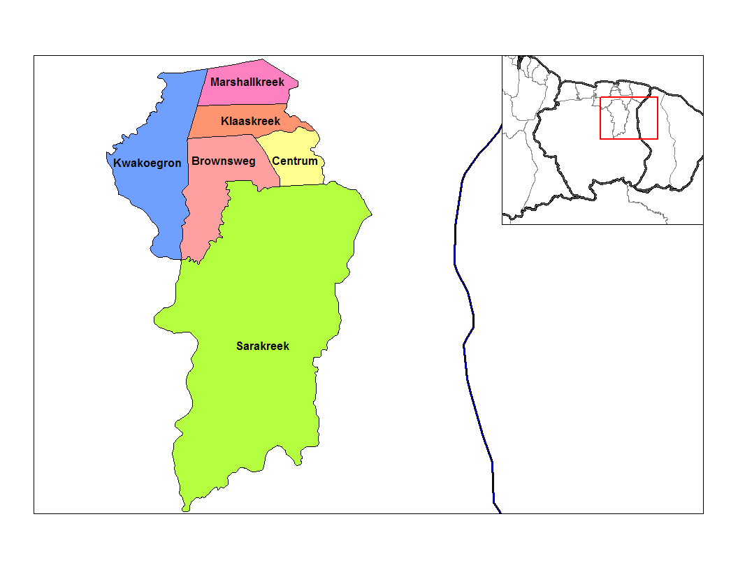
Klaaskreek is a resort in Suriname, located in the Brokopondo District. Its population at the 2012 census was 2,124. Located northeast of Brokopondo, the main town is Reinsdorp. In 2007, a technical training centre in biological agriculture was established at Klaaskreek to teach locals about enhancing agriculture in the area. History Around 1860 an expedition lead by J. Rosenberg set out to discover gold. Even though some gold was discovered near Victoria, the government decided not pursue the matter. Rosenberg however persisted, established the ''New-York and Surinam Company'', and finally received a concession in 1870. The company failed it meet its objectives, and the concession was nullified in 1874. Klaaskreek is situated in the proximity of the Brokopondo Reservoir. In 1958 Klaaskreek was designated as one of the transmigration towns for the inhabitants of the area that was flooded after the construction of the Afobaka Dam, and the main settlement for people from Ganzee ... [...More Info...] [...Related Items...] OR: [Wikipedia] [Google] [Baidu] |
Districts Of Suriname
Suriname is divided into 10 districts ( nl, districten). Overview History The country was first divided up into subdivisions by the Netherlands, Dutch on October 8, 1834, when a Royal Decree declared that there were to be 8 divisions and 2 districts: *Upper Suriname and Torarica *Para *Upper Commewijne *Upper Cottica and Perica *Lower Commewijne *Lower Cottica *Matapica *Saramacca *Coronie (district) *Nickerie (district) The divisions were areas near the capital city, Paramaribo, and the districts were areas further away from the city. In 1927, Suriname's districts were revised, and the country was divided into 7 districts. In 1943, 1948, 1949, 1952 and 1959 further small modifications were made. On October 28, 1966, the districts were redrawn again, into *Nickerie *Coronie *Saramacca *Brokopondo *Para *Suriname *Paramaribo *Commewijne *Marowijne These divisions remained until 1980, when yet again, the borders of the districts were redrawn, however, with the following requir ... [...More Info...] [...Related Items...] OR: [Wikipedia] [Google] [Baidu] |
Brokopondo District
Brokopondo is a district of Suriname. Its capital city is Brokopondo; other towns include Brownsweg and Kwakoegron. The district has a population of 15,909, and an area of 7,364 square kilometres. History The Brokopondo district was established in 1958 out of the former Suriname District. The establishment of the district was related to the 1958 Brokopondo Agreement between the Government of Suriname and Alcoa for the creation of the Brokopondo Reservoir. The Brokopondo Reservoir is a large reservoir near Afobaka which was built between 1961 and 1964, and produces hydroelectric power that provides approximately half of the domestic electrical need. The plan was very controversial, and involved transmigrating many villages that were located in the area and flooded after the construction of the Afobaka Dam. The transmigration concerned 5,000 people which were almost exclusively Maroons. In 1960, the Afobakaweg was constructed to link the reservoir with Paramaribo and the rest o ... [...More Info...] [...Related Items...] OR: [Wikipedia] [Google] [Baidu] |
Suriname
Suriname (; srn, Sranankondre or ), officially the Republic of Suriname ( nl, Republiek Suriname , srn, Ripolik fu Sranan), is a country on the northeastern Atlantic coast of South America. It is bordered by the Atlantic Ocean to the north, French Guiana to the east, Guyana to the west, and Brazil to the south. At just under , it is the smallest sovereign state in South America. It has a population of approximately , dominated by descendants from the slaves and labourers brought in from Africa and Asia by the Dutch Empire and Republic. Most of the people live by the country's (north) coast, in and around its capital and largest city, Paramaribo. It is also List of countries and dependencies by population density, one of the least densely populated countries on Earth. Situated slightly north of the equator, Suriname is a tropical country dominated by rainforests. Its extensive tree cover is vital to the country's efforts to Climate change in Suriname, mitigate climate ch ... [...More Info...] [...Related Items...] OR: [Wikipedia] [Google] [Baidu] |
Maroon People
Maroons are descendants of African diaspora in the Americas, Africans in the Americas who escaped from slavery and formed their own settlements. They often mixed with indigenous peoples of the Americas, indigenous peoples, eventually ethnogenesis, evolving into separate creole cultures such as the Garifuna and the Mascogos. Etymology ''Maroon'', which can have a more general sense of being abandoned without resources, entered English around the 1590s, from the French adjective , meaning 'feral' or 'fugitive'. (Despite the same spelling, the meaning of 'reddish brown' for ''maroon'' did not appear until the late 1700s, perhaps influenced by the idea of maroon peoples.) The American Spanish word is also often given as the source of the English word ''maroon'', used to describe the runaway slave communities in Florida, in the Great Dismal Swamp maroons, Great Dismal Swamp on the border of Virginia and North Carolina, on colonial islands of the Caribbean, and in other parts of ... [...More Info...] [...Related Items...] OR: [Wikipedia] [Google] [Baidu] |
Saramaka
The Saramaka, Saamaka or Saramacca are one of six Maroon peoples (formerly called "Bush Negroes") in the Republic of Suriname and one of the Maroon peoples in French Guiana. In 2007, the Saramaka won a ruling by the Inter-American Court of Human Rights, Inter-American Court for Human Rights supporting their land rights in Suriname for lands they have historically occupied, over national government claims. It was a landmark decision for indigenous peoples in the world. They have received compensation for damages and control this fund for their own development goals. The word "Maroon" comes from the Spanish ''cimarrón'', which was derived from an Arawakan languages, Arawakan root. Since 1990 especially, some of the Saramaka have migrated to French Guiana due to extended civil war in Suriname. By the early 16th century, the term "maroon" (''cimarron'') was used throughout the Americas to designate slaves who had escaped from slavery and set up independent communities beyond colon ... [...More Info...] [...Related Items...] OR: [Wikipedia] [Google] [Baidu] |
Suriname River
The Suriname River (Dutch: ''Surinamerivier'') is 480 km long and flows through the country Suriname. Its sources are located in the Guiana Highlands on the border between the Wilhelmina Mountains and the Eilerts de Haan Mountains (where it is known as the Gran Rio). The river flows below the reservoir along Brokopondo, Berg en Dal, the migrant communities Klaaskreek and Nieuw-Lombé, Jodensavanne, Carolina, Ornamibo and Domburg, before reaching the capital Paramaribo on the left bank and Meerzorg on the right bank. At Nieuw-Amsterdam it is joined by the Commewijne and immediately thereafter at the sandspit Braamspunt it flows into the Atlantic Ocean. The river has several sets of rapids as well as a few dams, the largest of which is the Afobaka Dam. The river's flow is interrupted by the Brokopondo Reservoir, which therefore divides the river into two sections. The upstream section runs almost entirely through the Sipaliwini district, and the downstream section runs ... [...More Info...] [...Related Items...] OR: [Wikipedia] [Google] [Baidu] |
Afobaka Dam
The Afobaka Dam is an embankment dam with a main gravity dam section on the Suriname River near Afobaka in Brokopondo District of Suriname. The primary purpose of the dam is to generate hydroelectric power and it supports a 180 MW power station. In 1958, Suriname Aluminum Company LLC (), a subsidiary of Alcoa, gained an agreement with the Suriname government to build the dam to power an aluminium smelter. Construction began in 1961 and it was completed in 1964. About 75% of power generated is used for processing aluminum, the rest is used in Paramaribo downstream. The power station was operational in 1965 but the very large reservoir, Brokopondo Reservoir, was not completely filled until 1971. Greenhouse gases emitted from the reservoir resulted in poor water quality for decades. Highly acidic In computer science, ACID ( atomicity, consistency, isolation, durability) is a set of properties of database transactions intended to guarantee data validity despite errors, po ... [...More Info...] [...Related Items...] OR: [Wikipedia] [Google] [Baidu] |
Moravian Church
The Moravian Church ( cs, Moravská církev), or the Moravian Brethren, formally the (Latin: "Unity of the Brethren"), is one of the oldest Protestantism, Protestant Christian denomination, denominations in Christianity, dating back to the Bohemian Reformation of the 15th century and the History of the Moravian Church, Unity of the Brethren ( cs, Jednota bratrská, links=no) founded in the Kingdom of Bohemia, sixty years before Reformation, Luther's Reformation. The church's heritage can be traced to 1457 in Bohemian Crown territory, including its Lands of the Bohemian Crown, crown lands of Moravia and Silesia, which saw the emergence of the Hussite movement against several practices and doctrines of the Catholic Church. However, its name is derived from exiles who fled from Bohemia to Saxony in 1722 to escape the Counter-Reformation, establishing the Christian community of Herrnhut; hence it is also known in German language, German as the ("Unity of Brethren [of Herrnhut]"). T ... [...More Info...] [...Related Items...] OR: [Wikipedia] [Google] [Baidu] |


.jpg)
.jpg)
