|
Gabès
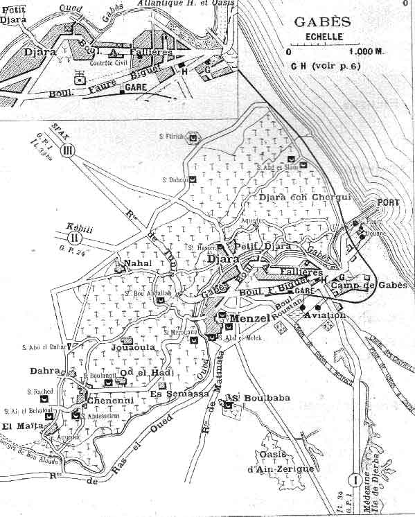
Gabès (, ; ar, قابس, ), also spelled Cabès, Cabes, Kabes, Gabbs and Gaps, is the capital city of the Gabès Governorate in Tunisia. It is located on the coast of the Gulf of Gabès. With a population of 152,921, Gabès is the 6th largest Tunisian city. Gabes is 327 km away from Tunis and 113 km away from Sfax. History Etymology Takapes, the ancient name of Gabès, is a Numidian ( Berber) toponym. Later, the prefix "Ta" (meaning "to" in Berber) was dropped, and the place became known as Kapes. As in Arabic the sound /p/ is unknown, Kapes became known as Kabes, and later known as Gabès. Roman period Gabès is the ancient ''Tacapae'' or ''Tacape'' (Τακάπη in Ancient greek) or ''Tacapes'' of the Roman province of Tripolitania. Strabo refers to this city as an important entrepot of the Lesser Syrtis. Pliny (18.22) remarks that the waters of a copious fountain at Tacape were divided among the cultivators according to a system where each had the use of the water d ... [...More Info...] [...Related Items...] OR: [Wikipedia] [Google] [Baidu] |
Gabès Governorate
__NOTOC__ Gabès Governorate ( ') is one of the 24 governorates of Tunisia and in south-eastern Tunisia. It covers an area of 7166 km2 and had a population of 374,300 as at the 2014 census. The capital is . Geography The governorate of Gabès is in southeast Tunisia on the coast of the , 376 km south of the capital, . Gabès has a hot Mediterranean climate. Gabès offers five contrastin ...[...More Info...] [...Related Items...] OR: [Wikipedia] [Google] [Baidu] |
Gulf Of Gabès
The Gulf of Gabes (or Cabès, Cabes, Gaps; ar, خليج قابس, ḫalīǧ Qābis), also known as Lesser Syrtis (from grc, Μικρά Σύρτις, Mikrá Sýrtis; la, Syrtis Minor), contrasting with the Greater Syrtis in Libya, is a gulf on Tunisia's east coast in the Mediterranean Sea, off North Africa. The gulf roughly spans the coast from Sfax to Djerba. At the head of the gulf is the city of Gabès (Ghannouche) where the tides have a large range of up to 2.1 m at spring tides.National Geospatial-Intelligence Agency (2002Section 8: Tunisia–Cap Serrat to Ras Ajdir"''Sailing Directions (Enroute) for Western Mediterranean'' (tenth edition) National Geospatial-Intelligence Agency, Bethesda, Maryland, page 102 Both Gabès and Sfax are major ports on the gulf, supporting sponge and tuna fisheries, with Gabès being the economic and administrative center. History The Latin name ''Syrtis Minor'' is used by Pliny the Elder, quoting an earlier description in Polybiusbr>1.39 ... [...More Info...] [...Related Items...] OR: [Wikipedia] [Google] [Baidu] |
Delegations Of Tunisia
The delegations of Tunisia (''mutamadiyah'', plural ''mutamadiyat'') are the second level administrative divisions of Tunisia between the governorates and the sectors (''imadats''). there were 24 governorates which were divided into 264 delegations and further divided into 2073 sectors. The delegations are listed below, organized by governorate. Ariana Delegations of Ariana: * Ariana * Ettadhamen * Kalaat El Andalous * Mnihla *Raoued *Sidi Thabet *Soukra Beja Delegations of Beja: *Amdoun * Beja *Goubellat *Majaz al Bab *Nefza * Teboursouk * Testour *Thibar Ben Arous Delegations of Ben Arous: * Ben Arous * Bou Mhel el-Bassatine *El Mourouj * Ezzahra * Fouchana * Hammam Chott *Hammam Lif *Mohamedia *Medina Jedida * Megrine * Mornag * Rades Bizerte Delegations of Bizerte: *Bizerte *Djoumime * El Alia *Ghar El Melh * Ghezala * Mateur *Menzel Bourguiba * Menzel Jemil * Ras Jebel *Sejenane * Tinja * Utica *Zarzouna Gabès Delegations of Gabès: * Gabes *Ghannouch * Hamma * ... [...More Info...] [...Related Items...] OR: [Wikipedia] [Google] [Baidu] |
List Of Cities In Tunisia
This is the list of 350 cities and towns in Tunisia. In the list by governorate, capitals are shown in bold. List of most-populated cities List of municipalities by governorate See also * * List of cities by country * Governorates of Tunisia * List of metropolitan areas in Africa * List of largest cities in the Arab world References External links {{Africa in topic, List of cities in Tunisia, List of cities in Tunisia Cities A city is a human settlement of notable size.Goodall, B. (1987) ''The Penguin Dictionary of Human Geography''. London: Penguin.Kuper, A. and Kuper, J., eds (1996) ''The Social Science Encyclopedia''. 2nd edition. London: Routledge. It can be def ... ... [...More Info...] [...Related Items...] OR: [Wikipedia] [Google] [Baidu] |
Sfax
Sfax (; ar, صفاقس, Ṣafāqis ) is a city in Tunisia, located southeast of Tunis. The city, founded in AD849 on the ruins of Berber Taparura, is the capital of the Sfax Governorate (about 955,421 inhabitants in 2014), and a Mediterranean port. Sfax has a population of 330,440 (census 2014). The main industries are phosphate, olive and nut processing, fishing (largest fishing port in Tunisia) and international trade. The city is the second-most populous after the capital, Tunis. History Carthaginian and Aghlabid eras Present-day Sfax was founded in AD849 on the site of the Berber town of Taparura. The modern city has also grown to cover some other ancient settlements, most notably Thenae in its southern suburb of Thyna. Almohad era By the end of the 10th century, Sfax had become an independent city-state. The city was conquered by Roger II of Sicily in 1148 and occupied until it was liberated in 1156 by the Almohads, and was briefly occupied by European ... [...More Info...] [...Related Items...] OR: [Wikipedia] [Google] [Baidu] |
Pliny The Elder
Gaius Plinius Secundus (AD 23/2479), called Pliny the Elder (), was a Roman author, naturalist and natural philosopher, and naval and army commander of the early Roman Empire, and a friend of the emperor Vespasian. He wrote the encyclopedic '' Naturalis Historia'' (''Natural History''), which became an editorial model for encyclopedias. He spent most of his spare time studying, writing, and investigating natural and geographic phenomena in the field. His nephew, Pliny the Younger, wrote of him in a letter to the historian Tacitus: Among Pliny's greatest works was the twenty-volume work ''Bella Germaniae'' ("The History of the German Wars"), which is no longer extant. ''Bella Germaniae'', which began where Aufidius Bassus' ''Libri Belli Germanici'' ("The War with the Germans") left off, was used as a source by other prominent Roman historians, including Plutarch, Tacitus and Suetonius. Tacitus—who many scholars agree had never travelled in Germania—used ''Bella Germa ... [...More Info...] [...Related Items...] OR: [Wikipedia] [Google] [Baidu] |
Governorates Of Tunisia
Tunisia is divided into 24 governorates (''wilayat'', sing. '' wilayah''). This term in Arabic can also be translated as province or federated state (though the latter does not apply, as Tunisia is a unitary state). The governorates are divided into 264 delegations (''mutamadiyat''), and further subdivided into municipalities (''baladiyat''), and sectors (''imadats''). Tunisia is divided into 6 regions. It is mostly temperate near the capital Tunis, but becomes more arid in the southern regions due to the Saharan Desert. See also * Grand Tunis Grand Tunis or Greater Tunis (Arabic: ''تونس الكبرى'', French: ''Grand Tunis'') is the largest metropolitan area in Tunisia, centered on the country's capital Tunis. It consists of four governorates: Tunis, Ariana, Manouba Manouba ( a ... * ISO 3166-2:TN References {{DEFAULTSORT:Governorates Of Tunisia Subdivisions of Tunisia Tunisia, Governorates Tunisia 1 Governorates, Tunisia Tunisia geography-rel ... [...More Info...] [...Related Items...] OR: [Wikipedia] [Google] [Baidu] |
Tunisia
) , image_map = Tunisia location (orthographic projection).svg , map_caption = Location of Tunisia in northern Africa , image_map2 = , capital = Tunis , largest_city = capital , coordinates = , official_languages = Arabic Translation by the University of Bern: "Tunisia is a free State, independent and sovereign; its religion is the Islam, its language is Arabic, and its form is the Republic." , religion = , languages_type = Spoken languages , languages = Minority Dialects : Jerba Berber (Chelha) Matmata Berber Judeo-Tunisian Arabic (UNESCO CR) , languages2_type = Foreign languages , languages2 = , ethnic_groups = * 98% Arab * 2% Other , demonym = Tunisian , government_type = Unitary presidential republic , leader_title1 = President , leader_name1 = Kais Saied , leader_t ... [...More Info...] [...Related Items...] OR: [Wikipedia] [Google] [Baidu] |
Bishopric
In church governance, a diocese or bishopric is the ecclesiastical district under the jurisdiction of a bishop. History In the later organization of the Roman Empire, the increasingly subdivided provinces were administratively associated in a larger unit, the diocese (Latin ''dioecesis'', from the Greek term διοίκησις, meaning "administration"). Christianity was given legal status in 313 with the Edict of Milan. Churches began to organize themselves into dioceses based on the civil dioceses, not on the larger regional imperial districts. These dioceses were often smaller than the provinces. Christianity was declared the Empire's official religion by Theodosius I in 380. Constantine I in 318 gave litigants the right to have court cases transferred from the civil courts to the bishops. This situation must have hardly survived Julian, 361–363. Episcopal courts are not heard of again in the East until 398 and in the West in 408. The quality of these courts was ... [...More Info...] [...Related Items...] OR: [Wikipedia] [Google] [Baidu] |
Sabratha
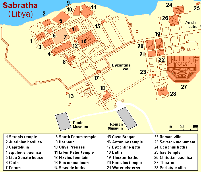
Sabratha ( ar, صبراتة, Ṣabrāta; also ''Sabratah'', ''Siburata''), in the Zawiya District''شعبيات الجماهيرية العظمى''Sha'biyat of Great Jamahiriya accessed 20 July 2009, in Arabic of , was the westernmost of the ancient "three cities" of Roman Tripolis, alongside Oea and . From 2001 to 20 ... [...More Info...] [...Related Items...] OR: [Wikipedia] [Google] [Baidu] |
Macomades
Macomades was a Carthaginian and Roman city in North Africa. It was located near present-day Oum-El-Bouaghi, Algeria History Macomades was established as an inland Punic trading post under the name ( xpu, 𐤌𐤒𐤌𐤀, "Place"). It was about from Cirta. It issued its own bronze coins with an Egyptian-style god's head obverse and a reverse bearing either a hog and galloping horse or a disk in a crescent, a symbol of the Punic goddess Tanit. It was a town in the Roman province of Numidia. It was overrun by the Umayyad Caliphate during the 7th-century Muslim invasion. Religion No later than AD256, the town was the seat of a Christian bishop. The diocese was in abeyance after the Muslim conquest of the region until it was restored by the Roman Catholic Church in 1933 as a titular bishopric ('). List of bishops * Cas ...[...More Info...] [...Related Items...] OR: [Wikipedia] [Google] [Baidu] |
Tabula Peutingeriana
' (Latin for "The Peutinger Map"), also referred to as Peutinger's Tabula or Peutinger Table, is an illustrated ' (ancient Roman road map) showing the layout of the '' cursus publicus'', the road network of the Roman Empire. The map is a 13th-century parchment copy of a possible Roman original. It covers Europe (without the Iberian Peninsula and the British Isles), North Africa, and parts of Asia, including the Middle East, Persia, and India. According to one hypothesis, the existing map is based on a document of the 4th or 5th century that contained a copy of the world map originally prepared by Agrippa during the reign of the emperor Augustus (27 BC – AD 14). However, Emily Albu has suggested that the existing map could instead be based on an original from the Carolingian period. The map was likely stolen by the renowned humanist Conrad Celtes, who bequeathed it to his friend, the economist and archaeologist Konrad Peutinger, who gave it to Emperor Maximilian I, as part of ... [...More Info...] [...Related Items...] OR: [Wikipedia] [Google] [Baidu] |


