|
Fisherwick
Fisherwick is a civil parish in Lichfield District, Staffordshire, England. Located about east of the City of Lichfield, the parish does not include a village, just a scattered collection of farms and houses. The ancient settlement, dating back to the 12th century, and the manor of ''Fisherwick Park'' no longer exist. The parish council is a joint one with Whittington. See also *Listed buildings in Fisherwick Fisherwick is a civil parish in the district of Lichfield District, Lichfield, Staffordshire, England. The parish contains seven Listed building#England and Wales, listed buildings that are recorded in the National Heritage List for England. All ... * Baron Fisherwick References External links Whittington and Fisherwick Parish Council Website Civil parishes in Staffordshire {{Staffordshire-geo-stub ... [...More Info...] [...Related Items...] OR: [Wikipedia] [Google] [Baidu] |
Listed Buildings In Fisherwick
Fisherwick is a civil parish in the district of Lichfield, Staffordshire, England. The parish contains seven listed buildings that are recorded in the National Heritage List for England. All the listed buildings are designated at Grade II, the lowest of the three grades, which is applied to "buildings of national importance and special interest". The parish is entirely rural, without any significant settlements. The listed buildings consist of three farmhouses and associated structures, a bridge over the River Tame, two bridges over the Birmingham and Fazeley Canal, and the gate piers Piers may refer to: * Pier, a raised structure over a body of water * Pier (architecture), an architectural support * Piers (name), a given name and surname (including lists of people with the name) * Piers baronets, two titles, in the baronetages ... on the drive of a house that has been demolished. __NOTOC__ Buildings References Citations Sources * * * * * * * * {{DEFAULTSO ... [...More Info...] [...Related Items...] OR: [Wikipedia] [Google] [Baidu] |
Tamhorn House Bridge
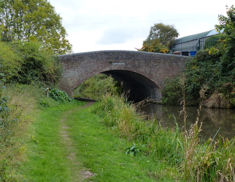
Tamhorn is a former civil parish, now in the parish of Fisherwick, in the Lichfield district, in the county of Staffordshire, England, miles north-west of Tamworth. It was an extra-parochial area in Offlow hundred until 1858, when it became a civil parish. It was annexed to Fisherwick parish on 1 April 1934.Vision of Britain website; entry for Tamhorn http://www.visionofbritain.org.uk/place/8557 retrieved Oct 2018 It had an area 770 acres. The population was 5 in 1841 andCensus of England and Wales, 1841; County of Stafford, pp.288 19 in 1931, the last census before its annexation. It lies in the valley of the river Tame adjacent to the Birmingham and Fazeley Canal.History, Gazetteer and Directory of Staffordshire by William White (1834) p.379 The name Tamhorn is Old English meaning a bend in the river Tame or specifically the horn of land formed by the bend.History of the County of Stafford: Volume 14, Lichfield,publ.Victoria County History, London, 1990; pp. 237-239 It was ... [...More Info...] [...Related Items...] OR: [Wikipedia] [Google] [Baidu] |
Whittington, Staffordshire
Whittington is a village and civil parish which lies approximately 3 miles south east of Lichfield, in the Lichfield district of Staffordshire, England. According to the 2001 census it had a population of 2,591, increasing to 2,603 at the 2011 Census. The parish council is a joint one with Fisherwick. The Coventry Canal borders the village to the north and east. History The place name of Whittington derives from the Old English for an estate associated with a man called Hwīta. Hwīta was an Anglo-Saxon personal name meaning 'white', given to someone with fair hair or pale complexion. Whittington formed part of the Bishop of Lichfield’s great manorial estate, which covered much of south-east Staffordshire. Known as the Manor of Longdon, it had been created for the bishop of Lichfield from the time of the Saxons, they remained the lord of the manor until 1546 when the bishop was forced to surrender it to Sir William Paget, one of Henry VIII's principal Secretaries of State, wh ... [...More Info...] [...Related Items...] OR: [Wikipedia] [Google] [Baidu] |
Lichfield (district)
Lichfield () is a local government district in Staffordshire, England. It is administered by Lichfield District Council, based in Lichfield. The dignity and privileges of the City of Lichfield are vested in the parish council of the 14 km² Lichfield civil parish. The non-metropolitan district of Lichfield covers nearly 25 times this area and its local authority is Lichfield District Council. The district was formed on 1 April 1974, under the Local Government Act 1972, by a merger of the existing City of Lichfield with most of the Lichfield Rural District. Geography The district includes areas in two parliamentary constituencies: Lichfield and Tamworth. Settlements within the district *Alrewas, Armitage * Blithbury, Burntwood *Chase Terrace, Chasetown, Chorley, Clifton Campville, Colton, Comberford, Croxall, Curborough *Drayton Bassett * Edingale, Elford, Elmhurst * Farewell, Fazeley, Fisherwick, Fradley * Gentleshaw * Hademore, Hammerwich, Hamstall Ridware ... [...More Info...] [...Related Items...] OR: [Wikipedia] [Google] [Baidu] |
City Of Lichfield
Lichfield () is a cathedral city and civil parish in Staffordshire, England. Lichfield is situated roughly south-east of the county town of Stafford, south-east of Rugeley, north-east of Walsall, north-west of Tamworth and south-west of Burton Upon Trent. At the time of the 2011 Census, the population was estimated at 32,219 and the wider Lichfield District at 100,700. Notable for its three-spired medieval cathedral, Lichfield was the birthplace of Samuel Johnson, the writer of the first authoritative ''Dictionary of the English Language''. The city's recorded history began when Chad of Mercia arrived to establish his Bishopric in 669 AD and the settlement grew as the ecclesiastical centre of Mercia. In 2009, the Staffordshire Hoard, the largest hoard of Anglo-Saxon gold and silver metalwork, was found south-west of Lichfield. The development of the city was consolidated in the 12th century under Roger de Clinton, who fortified the Cathedral Close and also lai ... [...More Info...] [...Related Items...] OR: [Wikipedia] [Google] [Baidu] |
England
England is a country that is part of the United Kingdom. It shares land borders with Wales to its west and Scotland to its north. The Irish Sea lies northwest and the Celtic Sea to the southwest. It is separated from continental Europe by the North Sea to the east and the English Channel to the south. The country covers five-eighths of the island of Great Britain, which lies in the North Atlantic, and includes over 100 smaller islands, such as the Isles of Scilly and the Isle of Wight. The area now called England was first inhabited by modern humans during the Upper Paleolithic period, but takes its name from the Angles, a Germanic tribe deriving its name from the Anglia peninsula, who settled during the 5th and 6th centuries. England became a unified state in the 10th century and has had a significant cultural and legal impact on the wider world since the Age of Discovery, which began during the 15th century. The English language, the Anglican Church, and Engli ... [...More Info...] [...Related Items...] OR: [Wikipedia] [Google] [Baidu] |
Staffordshire
Staffordshire (; postal abbreviation Staffs.) is a landlocked county in the West Midlands region of England. It borders Cheshire to the northwest, Derbyshire and Leicestershire to the east, Warwickshire to the southeast, the West Midlands County and Worcestershire to the south and Shropshire to the west. The largest settlement in Staffordshire is Stoke-on-Trent, which is administered as an independent unitary authority, separately from the rest of the county. Lichfield is a cathedral city. Other major settlements include Stafford, Burton upon Trent, Cannock, Newcastle-under-Lyme, Rugeley, Leek, and Tamworth. Other towns include Stone, Cheadle, Uttoxeter, Hednesford, Brewood, Burntwood/Chasetown, Kidsgrove, Eccleshall, Biddulph and the large villages of Penkridge, Wombourne, Perton, Kinver, Codsall, Tutbury, Alrewas, Barton-under-Needwood, Shenstone, Featherstone, Essington, Stretton and Abbots Bromley. Cannock Chase AONB is within the county as well as parts of the ... [...More Info...] [...Related Items...] OR: [Wikipedia] [Google] [Baidu] |
West Midlands (region)
The West Midlands is one of nine official regions of England at the ITL 1 statistical regions of England, first level of International Territorial Level for Statistics, statistical purposes. It covers the western half of the area traditionally known as the Midlands (England), Midlands. The region consists of the ceremonial counties of england, counties of Herefordshire, Shropshire, Staffordshire, Warwickshire, West Midlands (county), West Midlands and Worcestershire. The region has seven cities; Birmingham, Coventry, Hereford, Lichfield, Stoke-on-Trent, Wolverhampton and Worcester, England, Worcester. The West Midlands region is geographically diverse, from the urban central areas of the West Midlands conurbation to the rural counties of Herefordshire, Shropshire and Worcestershire which border Wales. The region is landlocked. However, the longest river in the UK, the River Severn, traverses the region southeastwards, flowing through the county towns of Shrewsbury and Worc ... [...More Info...] [...Related Items...] OR: [Wikipedia] [Google] [Baidu] |
List Of United Kingdom Parliament Constituencies
The Parliament of the United Kingdom currently has 650 parliamentary constituencies across the constituent countries (England, Scotland, Wales and Northern Ireland), each electing a single member of parliament (MP) to the House of Commons by the plurality (first past the post) voting system, ordinarily every five years. Voting last took place in all 650 of those constituencies at the United Kingdom general election on 12 December 2019. The number of seats rose from 646 to 650 at the 2010 general election after proposals made by the boundary commissions for England, Wales and Northern Ireland (the Fifth Periodic Review of Westminster constituencies) were adopted through statutory instruments. Constituencies in Scotland remained unchanged, as the Boundary Commission for Scotland had completed a review just before the 2005 general election, which had resulted in a reduction of 13 seats. Primary legislation provides for the independence of the boundary commissions for each ... [...More Info...] [...Related Items...] OR: [Wikipedia] [Google] [Baidu] |
Lichfield (UK Parliament Constituency)
Lichfield is a United Kingdom constituencies, constituency in Staffordshire represented in the House of Commons of the United Kingdom, House of Commons of the Parliament of the United Kingdom, UK Parliament since its 1997 United Kingdom general election, 1997 recreation by Michael Fabricant, a Conservative Party (UK), Conservative. Boundaries ; 1918–1950: The Boroughs of Lichfield and Tamworth, the Urban Districts of Perry Barr and Rugeley, the Rural District of Lichfield, and parts of the Rural Districts of Tamworth and Walsall. ; 1997–2010: The Lichfield District, District of Lichfield wards of All Saints, Alrewas, Armitage with Handsacre, Boney Hay, Central, Chadsmead, Chase Terrace, Chasetown, Colton and Ridwares, Curborough, Hammerwich, Highfield, King's Bromley, Leomansley, Longdon, Redslade, St John's, Stowe, Summerfield, and Whittington, and the Borough of East Staffordshire wards of Bagots and Yoxall. ; 2010 onwards: The District of Lichfield wards of All Saints, ... [...More Info...] [...Related Items...] OR: [Wikipedia] [Google] [Baidu] |
Civil Parish
In England, a civil parish is a type of administrative parish used for local government. It is a territorial designation which is the lowest tier of local government below districts and counties, or their combined form, the unitary authority. Civil parishes can trace their origin to the ancient system of ecclesiastical parishes, which historically played a role in both secular and religious administration. Civil and religious parishes were formally differentiated in the 19th century and are now entirely separate. Civil parishes in their modern form came into being through the Local Government Act 1894, which established elected parish councils to take on the secular functions of the parish vestry. A civil parish can range in size from a sparsely populated rural area with fewer than a hundred inhabitants, to a large town with a population in the tens of thousands. This scope is similar to that of municipalities in Continental Europe, such as the communes of France. However, ... [...More Info...] [...Related Items...] OR: [Wikipedia] [Google] [Baidu] |
Parish Councils In England
Parish councils are civil local authorities found in England which are the lowest tier of local government. They are elected corporate bodies, with variable tax raising powers, and they carry out beneficial public activities in geographical areas known as civil parishes. There are about 9,000 parish and town councils in England, and over 16 million people live in communities served by them. Parish councils may be known by different styles, they may resolve to call themselves a town council, village council, community council, neighbourhood council, or if the parish has city status, it may call itself a city council. However their powers and duties are the same whatever name they carry.Local Government and Public Involvement in Health Act 2007 Parish councils receive the majority of their funding by levying a precept upon the council tax paid by the residents of the parish (or parishes) covered by the council. In 2021-22 the amount raised by precept was £616 million. Other fund ... [...More Info...] [...Related Items...] OR: [Wikipedia] [Google] [Baidu] |


