|
Fortunato F. Halili Avenue
The Governor Fortunato F. Halili Avenue or simply the Governor Halili Ave, is a two-to-four lane national road and one of the major thoroughfares of the city of San Jose del Monte and the municipalities of Santa Maria and Bocaue in Bulacan, Philippines, named after the former governor of Bulacan. Many establishments are located along this 6-kilometer road. Route description Halili Avenue starts at the MacArthur Highway in the municipality of Bocaue in Bulacan. Its first major junction was the North Luzon Expressway The North Luzon Expressway (NLEX), signed as E1 of the Philippine expressway network, partially as N160 of the Philippine highway network, and R-8 of the Metro Manila arterial road network, is a limited-access toll expressway that connects M ... or NLEx. It enters Santa Maria after the NLEx-Bocaue junction. It was bisected near the Santa Maria bridge and continues as Santa Maria -Tungkong Mangga Road. It enters San Jose del Monte after a few meters. It term ... [...More Info...] [...Related Items...] OR: [Wikipedia] [Google] [Baidu] |
San Jose Del Monte
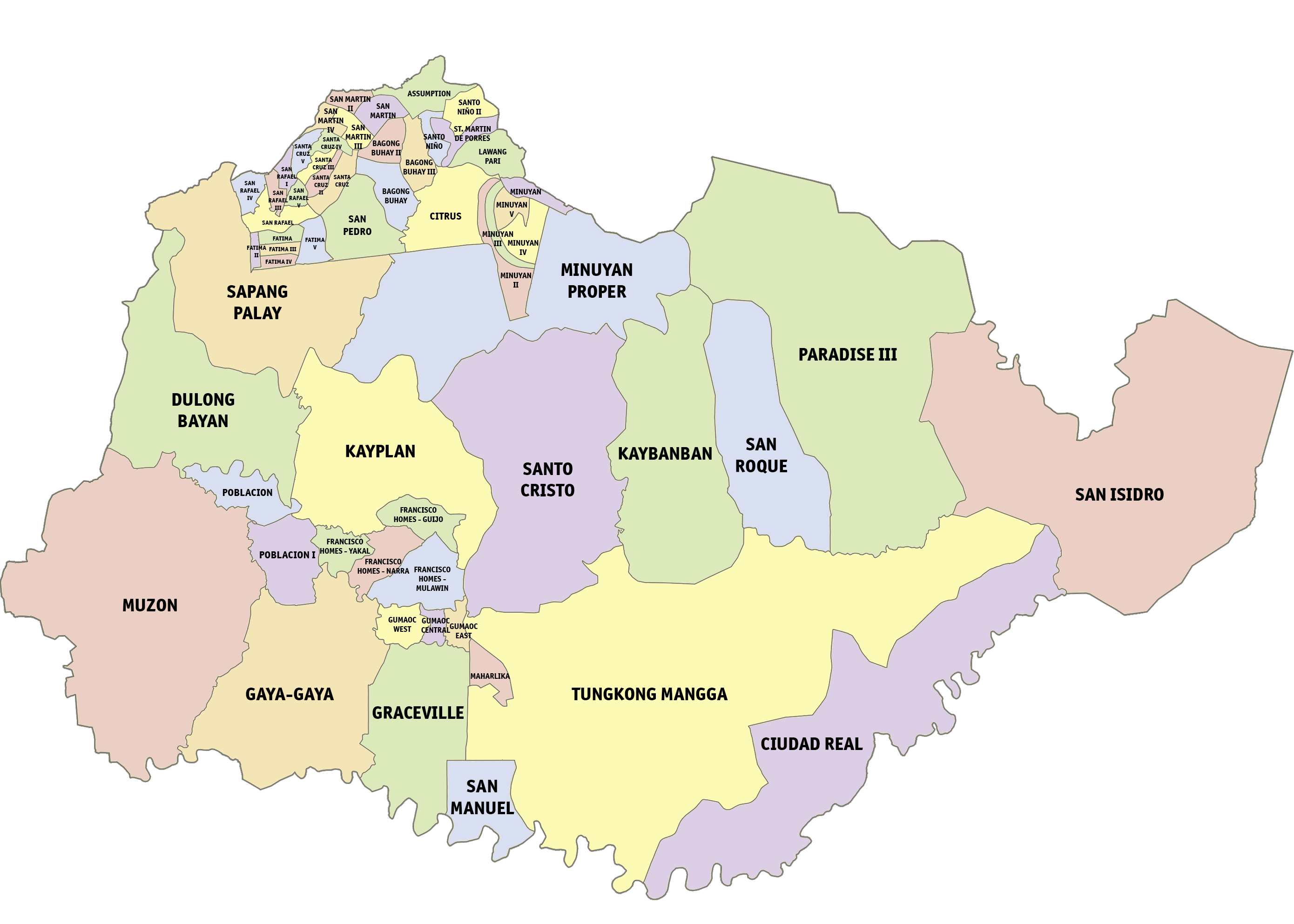
San Jose del Monte, officially the City of San Jose del Monte (abbreviated as SJDM or CSJDM; fil, Lungsod ng San Jose del Monte), is a 1st class component city in the province of Bulacan, Philippines. According to the 2020 census, it has a population of 651,813 people, making it the largest local government unit within the province of Bulacan and Central Luzon and the 18th most populated city in the Philippines. The City of San Jose del Monte, has proclaimed as a highly-urbanized city on December 4, 2020, by the virtue of Proclamation No. 1057, signed by President Rodrigo Duterte and shall take effect after the ratification in a plebiscite. Located in the southeast of the province, it is bordered by the city of Caloocan in Metro Manila to the south, by the town of Rodriguez, Rizal to the east, the towns of Santa Maria and Marilao to the west and Norzagaray to the north. The city is home to some of the biggest resettlement areas in the Philippines like the Sapang Palay rese ... [...More Info...] [...Related Items...] OR: [Wikipedia] [Google] [Baidu] |
North Luzon Expressway
The North Luzon Expressway (NLEX), signed as E1 of the Philippine expressway network, partially as N160 of the Philippine highway network, and R-8 of the Metro Manila arterial road network, is a limited-access toll expressway that connects Metro Manila to the provinces of the Central Luzon region in the Philippines. The expressway, which includes the main segment and its various spurs, has a total length of and travels from its northern terminus at Sta. Ines Interchange to its southern terminus in Balintawak Interchange, which is adjacent to its connection to Skyway, an elevated toll road that connects the NLEX to its counterpart in the south, the South Luzon Expressway. The segment of the expressway between Santa Rita Exit in Guiguinto and the Balintawak Interchange in Quezon City is part of Asian Highway 26 of the Asian highway network. The expressway also serves as a major utility corridor, carrying various high voltage overhead power lines through densely populated area ... [...More Info...] [...Related Items...] OR: [Wikipedia] [Google] [Baidu] |
Bocaue, Bulacan
Bocaue, officially the Municipality of Bocaue ( tgl, Bayan ng Bocaue), is a 1st class municipality of the Philippines, municipality in the Philippine Province, province of Bulacan, Philippines. According to the 2020 census, it has a population of 141,412 people. With the continuous expansion of Metro Manila, the municipality is now part of Greater Manila Area, Manila's built-up area which reaches San Ildefonso, Bulacan, San Ildefonso in its northernmost part. The Bocaue River runs through most of the town. Among its tourist attractions are a town museum located near the municipality's center and the town's river festival celebrated on the first Sunday of every July. The river festival is in commemoration of the Holy Cross of Wawa, believed to be miraculous by the town's predominantly Roman Catholic population. Etymology The town's name comes from the Old Tagalog word "''Bukawe''", which refers to a type of long bamboo (''Schizostachyum lima, Schyzostachyum lima''). History Boca ... [...More Info...] [...Related Items...] OR: [Wikipedia] [Google] [Baidu] |
Bulacan
Bulacan, officially the Province of Bulacan ( tl, Lalawigan ng Bulacan), is a province in the Philippines located in the Central Luzon region. Its capital is the city of Malolos. Bulacan was established on August 15, 1578, and part of the Metro Luzon Urban Beltway Super Region. It has 569 barangays in 20 municipalities and four component cities (Baliuag, Malolos the provincial capital, Meycauayan, and San Jose del Monte). Bulacan is located immediately north of Metro Manila. Bordering Bulacan are the provinces of Pampanga to the west, Nueva Ecija to the north, Aurora and Quezon to the east, and Metro Manila and Rizal to the south. Bulacan also lies on the north-eastern shore of Manila Bay. In the 2020 census, Bulacan had a population of 3,708,890 people, the most populous in Central Luzon and the third most populous in the Philippines, after Cebu and Cavite. Bulacan's most populated city is San Jose del Monte, the most populated municipality is Santa Maria while the least po ... [...More Info...] [...Related Items...] OR: [Wikipedia] [Google] [Baidu] |
Santa Maria, Bulacan
Santa Maria ( , ), officially the Municipality of Santa Maria ( tgl, Bayan ng Santa Maria), is a 1st class municipality of the Philippines, municipality in the Philippine Province, province of Bulacan, Philippines. According to the 2020 census, it has a population of 289,820 people. representing 7.8% of the population of the province. Located on the banks of the Santa Maria River (Philippines), Santa Maria River, north of Manila, Santa Maria has been a thriving settlement for almost four centuries. It was founded as a ''barrio'' of Bocaue in the early 17th century until it was established as an independent municipality on November 26, 1793, by the Spanish Friars in Colonial Philippines, Spanish friar Francisco Dominguez Javier Franciscan, OFM. Known before as ''Santa Maria de Pandi'' (), it is named under the patronage of the Virgin Mary, Immaculate Conception (also known as La Purisima Concepcion). Its administrative center, the Poblacion, forms as the historic core of the mun ... [...More Info...] [...Related Items...] OR: [Wikipedia] [Google] [Baidu] |
Bocaue
Bocaue, officially the Municipality of Bocaue ( tgl, Bayan ng Bocaue), is a 1st class municipality in the province of Bulacan, Philippines. According to the 2020 census, it has a population of 141,412 people. With the continuous expansion of Metro Manila, the municipality is now part of Manila's built-up area which reaches San Ildefonso in its northernmost part. The Bocaue River runs through most of the town. Among its tourist attractions are a town museum located near the municipality's center and the town's river festival celebrated on the first Sunday of every July. The river festival is in commemoration of the Holy Cross of Wawa, believed to be miraculous by the town's predominantly Roman Catholic population. Etymology The town's name comes from the Old Tagalog word "''Bukawe''", which refers to a type of long bamboo ('' Schyzostachyum lima''). History Bocaue was first established by Franciscan missionaries as a barrio and visita of Meycauayan in 1582 and as a town on Apri ... [...More Info...] [...Related Items...] OR: [Wikipedia] [Google] [Baidu] |
Philippines
The Philippines (; fil, Pilipinas, links=no), officially the Republic of the Philippines ( fil, Republika ng Pilipinas, links=no), * bik, Republika kan Filipinas * ceb, Republika sa Pilipinas * cbk, República de Filipinas * hil, Republika sang Filipinas * ibg, Republika nat Filipinas * ilo, Republika ti Filipinas * ivv, Republika nu Filipinas * pam, Republika ning Filipinas * krj, Republika kang Pilipinas * mdh, Republika nu Pilipinas * mrw, Republika a Pilipinas * pag, Republika na Filipinas * xsb, Republika nin Pilipinas * sgd, Republika nan Pilipinas * tgl, Republika ng Pilipinas * tsg, Republika sin Pilipinas * war, Republika han Pilipinas * yka, Republika si Pilipinas In the recognized optional languages of the Philippines: * es, República de las Filipinas * ar, جمهورية الفلبين, Jumhūriyyat al-Filibbīn is an archipelagic country in Southeast Asia. It is situated in the western Pacific Ocean and consists of around 7,641 islands t ... [...More Info...] [...Related Items...] OR: [Wikipedia] [Google] [Baidu] |
Roads In Bulacan
A road is a linear way for the conveyance of traffic that mostly has an improved surface for use by vehicles (motorized and non-motorized) and pedestrians. Unlike streets, the main function of roads is transportation. There are many types of roads, including parkways, avenues, controlled-access highways (freeways, motorways, and expressways), tollways, interstates, highways, thoroughfares, and local roads. The primary features of roads include lanes, sidewalks (pavement), roadways (carriageways), medians, shoulders, verges, bike paths (cycle paths), and shared-use paths. Definitions Historically many roads were simply recognizable routes without any formal construction or some maintenance. The Organization for Economic Co-operation and Development (OECD) defines a road as "a line of communication (travelled way) using a stabilized base other than rails or air strips open to public traffic, primarily for the use of road motor vehicles running on their own wheels", which i ... [...More Info...] [...Related Items...] OR: [Wikipedia] [Google] [Baidu] |


