|
Fife Heights, Washington
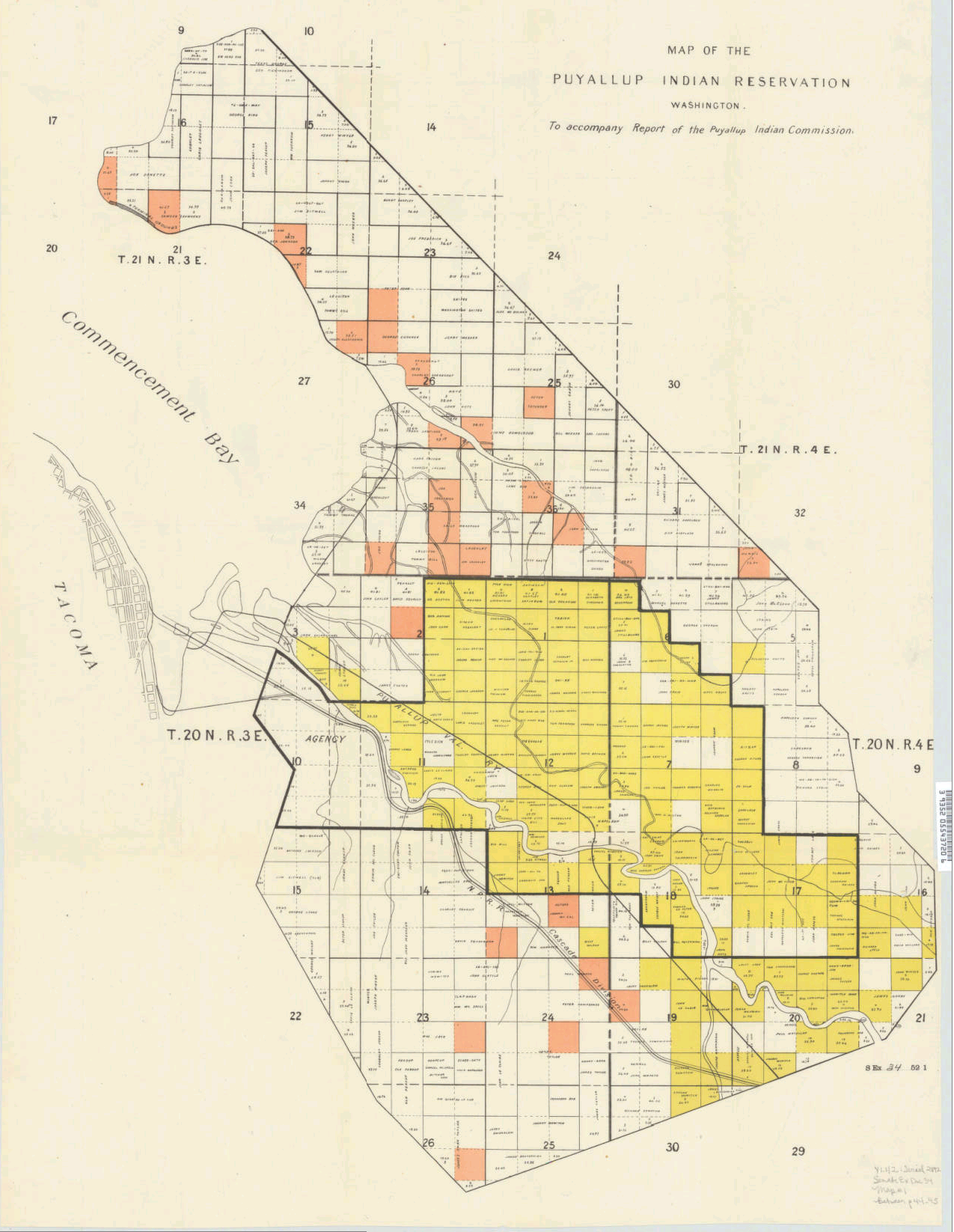
Fife Heights is a census-designated place (CDP) in Pierce County, Washington, Pierce County, Washington (U.S. state), Washington, United States. The population was 2,137 at the 2010 United States Census, 2010 census. The community is bordered by Federal Way, Washington, Federal Way on the north, Milton, Washington, Milton on the east, Fife, Washington, Fife on the south, and Tacoma, Washington, Tacoma on the west. It is contained within the Puyallup Indian Reservation. Education Fife Heights is served by Fife Public Schools, a public school district. References Census-designated places in Pierce County, Washington Census-designated places in Washington (state) {{PierceCountyWA-geo-stub ... [...More Info...] [...Related Items...] OR: [Wikipedia] [Google] [Baidu] |
Census-designated Place
A census-designated place (CDP) is a concentration of population defined by the United States Census Bureau for statistical purposes only. CDPs have been used in each decennial census since 1980 as the counterparts of incorporated places, such as self-governing cities, towns, and villages, for the purposes of gathering and correlating statistical data. CDPs are populated areas that generally include one officially designated but currently unincorporated community, for which the CDP is named, plus surrounding inhabited countryside of varying dimensions and, occasionally, other, smaller unincorporated communities as well. CDPs include small rural communities, edge cities, colonias located along the Mexico–United States border, and unincorporated resort and retirement communities and their environs. The boundaries of any CDP may change from decade to decade, and the Census Bureau may de-establish a CDP after a period of study, then re-establish it some decades later. Most unin ... [...More Info...] [...Related Items...] OR: [Wikipedia] [Google] [Baidu] |
Federal Information Processing Standard
The Federal Information Processing Standards (FIPS) of the United States are a set of publicly announced standards that the National Institute of Standards and Technology (NIST) has developed for use in computer systems of non-military, American government agencies and contractors. FIPS standards establish requirements for ensuring computer security and interoperability, and are intended for cases in which suitable industry standards do not already exist. Many FIPS specifications are modified versions of standards the technical communities use, such as the American National Standards Institute (ANSI), the Institute of Electrical and Electronics Engineers (IEEE), and the International Organization for Standardization (ISO). Specific areas of FIPS standardization The U.S. government has developed various FIPS specifications to standardize a number of topics including: * Codes, e.g., FIPS county codes or codes to indicate weather conditions or emergency indications. In 1994, Nat ... [...More Info...] [...Related Items...] OR: [Wikipedia] [Google] [Baidu] |
Fife Public Schools
Fife Public Schools is a school district comprising parts of the Washington state cities of Fife, Milton, Edgewood, Tacoma, Pacific as well as unincorporated census-designated places Lakeland South and Fife Heights. The district was established on December 22, 1899. Fife Schools is a member of the Standard Bearer Network founded by thSchlechty Centerwhich is a non-profit organization that helps schools and districts to transform by emphasizing student engagement. Fife has been a member of the Standard Bearer Network since 2000. Boundary In Pierce County the district includes most of Fife, all of Fife Heights and the Pierce County portion of Milton, and portions of Edgewood and Tacoma. Text list In King County the district includes most of the King County portion of Milton, and portions of Lakeland South and Pacific. Text list/ref> Governance The Board of Directors for Fife Public Schools is an elected body of five school directors. Each director must reside and be a reg ... [...More Info...] [...Related Items...] OR: [Wikipedia] [Google] [Baidu] |
Puyallup Indian Reservation
The Puyallup, Spuyalpabš or S’Puyalupubsh (pronounced: Spoy-all-up-obsh) ('generous and welcoming behavior to all people, who enter our lands') are a List of federally recognized tribes in the United States, federally recognized Coast Salish peoples, Coast Salish Native Americans of the United States, Native American tribe from western Washington (state), Washington state, United States. They were relocated onto Indian reservation, reservation lands in what is today Tacoma, Washington, Tacoma, Washington, in late 1854, after signing the Treaty of Medicine Creek with the United States. Today they have an enrolled population of 6,700, of whom 3,000 live on the reservation. The Puyallup Indian Reservation is one of the most urban Indian reservations in the United States. It is located primarily in northern Pierce County, Washington, Pierce County, with a very small part extending north into the city of Federal Way, Washington, Federal Way, in King County, Washington, King County ... [...More Info...] [...Related Items...] OR: [Wikipedia] [Google] [Baidu] |
Tacoma, Washington
Tacoma ( ) is the county seat of Pierce County, Washington, United States. A port city, it is situated along Washington's Puget Sound, southwest of Seattle, northeast of the state capital, Olympia, Washington, Olympia, and northwest of Mount Rainier National Park. The city's population was 219,346 at the time of the 2020 United States census, 2020 census. Tacoma is the second-largest city in the Puget Sound area and the List of municipalities in Washington, third-largest in the state. Tacoma also serves as the center of business activity for the South Sound region, which has a population of about 1 million. Tacoma adopted its name after the nearby Mount Rainier, called wikt:Tacoma, təˡqʷuʔbəʔ in the Lushootseed, Puget Sound Salish dialect. It is locally known as the "City of Destiny" because the area was chosen to be the western terminus of the Northern Pacific Railroad in the late 19th century. The decision of the railroad was influenced by Tacoma's neighboring deep-wat ... [...More Info...] [...Related Items...] OR: [Wikipedia] [Google] [Baidu] |
Fife, Washington
Fife is a city in Pierce County, Washington, United States and a suburb of Tacoma. The population was 10,999 at the 2020 census. Fife is contained within the Puyallup Indian Reservation. History The lower Puyallup basin is the ancestral home of the Puyallup people, who were relocated after the signing of the Medicine Creek Treaty in 1854. The treaty ceded Puyallup lands and created the Puyallup Indian Reservation, which was expanded to include modern-day Fife. The land on which the city sits was lost after the signing of the General Allotment Act in 1887 and other land transfers that were later resolved in a 1990 claims settlement. In 1940, Fife was described as "at a valley crossroads in the midst of a thickly settled berry growing and truck-gardening district is represented by a string of markets, taverns, shops, and a large, balloon-roofed dance hall along the highway." The 1940 population was 135. Fife was officially incorporated on February 11, 1957. Due to the increas ... [...More Info...] [...Related Items...] OR: [Wikipedia] [Google] [Baidu] |
Milton, Washington
Milton is a city in King County, Washington, King and Pierce County, Washington, Pierce counties in the U.S. state of Washington (state), Washington. The population was 8,697 at the time of the 2020 United States census, 2020 census. Milton borders the larger but newer town of Edgewood, Washington, Edgewood. Geography Milton is located in northern Pierce County and southern King County at (47.248208, -122.317376). The Milton and Edgewood areas are known informally as North Hill. This contrasts with the South Hill, Washington, South Hill area on the opposite side of the Puyallup River valley. According to the United States Census Bureau, the city has a total area of , of which are land and are water. Climate This region experiences warm (but not hot) and dry summers, with no average monthly temperatures above . According to the Köppen Climate Classification system, Milton has a Mediterranean climate#Warm-summer Mediterranean climate, warm-summer Mediterranean climate, abbrev ... [...More Info...] [...Related Items...] OR: [Wikipedia] [Google] [Baidu] |
Federal Way, Washington
Federal Way is a city in King County, Washington, King County, Washington (state), Washington, United States. One of the most recently incorporated cities in the county, its population was 101,030 at the 2020 United States census, 2020 census. Federal Way is the List of municipalities in Washington, tenth-largest city in Washington and the fifth-largest in King County. History Originally a logging settlement, the area was first called "Federal Way" in 1929. The name derived from U.S. Route 99#Washington, Federal Highway U.S. 99 (now Washington State Route 99, State Route 99 or Pacific Highway (United States), Pacific Highway South), which ran from Everett, Washington, Everett and Seattle to Tacoma, Washington, Tacoma. The name "Federal Way" was first used in 1929 when five existing schools consolidated operations into Federal Way Public Schools, School District #210 and planned construction of Federal Way High School, which opened in 1930 and gave its name to the school district. ... [...More Info...] [...Related Items...] OR: [Wikipedia] [Google] [Baidu] |
Census-designated Place
A census-designated place (CDP) is a concentration of population defined by the United States Census Bureau for statistical purposes only. CDPs have been used in each decennial census since 1980 as the counterparts of incorporated places, such as self-governing cities, towns, and villages, for the purposes of gathering and correlating statistical data. CDPs are populated areas that generally include one officially designated but currently unincorporated community, for which the CDP is named, plus surrounding inhabited countryside of varying dimensions and, occasionally, other, smaller unincorporated communities as well. CDPs include small rural communities, edge cities, colonias located along the Mexico–United States border, and unincorporated resort and retirement communities and their environs. The boundaries of any CDP may change from decade to decade, and the Census Bureau may de-establish a CDP after a period of study, then re-establish it some decades later. Most unin ... [...More Info...] [...Related Items...] OR: [Wikipedia] [Google] [Baidu] |
Area Code 253
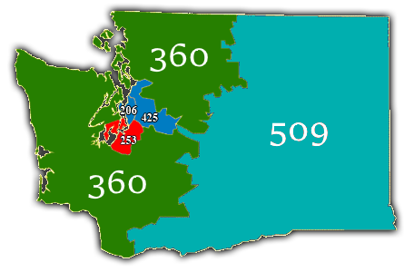
Area code 253 is a telephone area code in the North American Numbering Plan (NANP) for a part of the U.S. state of Washington, including the area south of Seattle and of the southern Puget Sound area, centered at Tacoma and extending to include the areas around Gig Harbor, Auburn, and Roy. It also serves the western half of Pierce County, as well as southern King County. The area code commenced service on April 27, 1997, as part of a three-way split of area code 206. The other of the three is area code 425. In the lead-up to the switchover, John Keister, on his television comedy show ''Almost Live!'', lampooned the fact that Renton wanted to join the 425 area code to be associated with the relatively wealthy Eastside, which includes Bellevue. Area code 253 participates in the complex overlay plan of area code 564, which also encompasses area codes 206, 360, and 425. Service area *Auburn * Bonney Lake * Burley * Covington *DuPont *Federal Way *Fife *Joint Base Lewis-McCho ... [...More Info...] [...Related Items...] OR: [Wikipedia] [Google] [Baidu] |
List Of Sovereign States
The following is a list providing an overview of sovereign states around the world with information on their status and recognition of their sovereignty. The 206 listed states can be divided into three categories based on membership within the United Nations System: 193 UN member states, 2 UN General Assembly non-member observer states, and 11 other states. The ''sovereignty dispute'' column indicates states having undisputed sovereignty (188 states, of which there are 187 UN member states and 1 UN General Assembly non-member observer state), states having disputed sovereignty (16 states, of which there are 6 UN member states, 1 UN General Assembly non-member observer state, and 9 de facto states), and states having a special political status (2 states, both in free association with New Zealand). Compiling a list such as this can be a complicated and controversial process, as there is no definition that is binding on all the members of the community of nations concerni ... [...More Info...] [...Related Items...] OR: [Wikipedia] [Google] [Baidu] |


