|
Evanston, WY
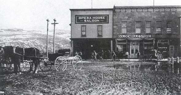
Evanston is a city in and the county seat of Uinta County, Wyoming, United States. The population was 12,359 at the 2010 census. It is located near the border with Utah. History Evanston was named after James A. Evans, a civil engineer for the Union Pacific Railroad. Another source maintains it is named for John Evans, second Governor of the Territory of Colorado. The town was founded during the construction of the First transcontinental railroad. The railroad arrived in the area in November 1868, and Harvey Booth opened a saloon/restaurant in a tent near what is now Front Street. By December the rails had reached Evanston and the first train arrived December 16. However, orders were later handed down by the railroad managers to move the end of the line 12 miles west, to Wasatch. Within three days, most all of Evanston had moved to Wasatch, it appeared that Evanston would become another "end of the tracks" town. Luckily, in June 1869 headquarters returned to Evanston and it ... [...More Info...] [...Related Items...] OR: [Wikipedia] [Google] [Baidu] |
City
A city is a human settlement of notable size.Goodall, B. (1987) ''The Penguin Dictionary of Human Geography''. London: Penguin.Kuper, A. and Kuper, J., eds (1996) ''The Social Science Encyclopedia''. 2nd edition. London: Routledge. It can be defined as a permanent and densely settled place with administratively defined boundaries whose members work primarily on non-agricultural tasks. Cities generally have extensive systems for housing, transportation, sanitation, utilities, land use, production of goods, and communication. Their density facilitates interaction between people, government organisations and businesses, sometimes benefiting different parties in the process, such as improving efficiency of goods and service distribution. Historically, city-dwellers have been a small proportion of humanity overall, but following two centuries of unprecedented and rapid urbanization, more than half of the world population now lives in cities, which has had profound consequences for g ... [...More Info...] [...Related Items...] OR: [Wikipedia] [Google] [Baidu] |
John Evans (Colorado Governor)
John Evans (March 9, 1814 – July 2, 1897) was an American politician, physician, founder of various hospitals and medical associations, railroad promoter, governor of the territory of Colorado, and namesake of Evanston, Illinois; Evans, Colorado; and Mount Evans, Colorado. He is most noted for being one of the founders of both Northwestern University and the University of Denver. The John Evans professorships, the highest honors bestowed on faculty members at both Northwestern University and the University of Denver, are named for him. By bringing railroad service to Denver from several directions, he was responsible for the growth of Denver from a settlement to a city. Evans was forced to resign the governorship in 1865 for his role in instigating the Sand Creek massacre, one of the worst massacres of Native Americans in U.S. history. Early life and education Evans was born in Waynesville, Ohio on March 9, 1814 to Welsh immigrants Rachel and David Evans, a farmer, har ... [...More Info...] [...Related Items...] OR: [Wikipedia] [Google] [Baidu] |
Humid Continental Climate
A humid continental climate is a climatic region defined by Russo-German climatologist Wladimir Köppen in 1900, typified by four distinct seasons and large seasonal temperature differences, with warm to hot (and often humid) summers and freezing cold (sometimes severely cold in the northern areas) winters. Precipitation is usually distributed throughout the year but often do have dry seasons. The definition of this climate regarding temperature is as follows: the mean temperature of the coldest month must be below or depending on the isotherm, and there must be at least four months whose mean temperatures are at or above . In addition, the location in question must not be semi-arid or arid. The cooler ''Dfb'', ''Dwb'', and ''Dsb'' subtypes are also known as hemiboreal climates. Humid continental climates are generally found between latitudes 30° N and 60° N, within the central and northeastern portions of North America, Europe, and Asia. They are rare and isolat ... [...More Info...] [...Related Items...] OR: [Wikipedia] [Google] [Baidu] |
Wyoming Highway 150
Wyoming Highway 150 (WYO 150) is a north–south Wyoming State Road that runs from the Wyoming–Utah state border to north to Evanston. It is the Wyoming portion of the Mirror Lake Scenic Byway. Route description Wyoming Highway 150 is the continuation of Utah State Route 150 along the Mirror Lake Scenic Byway. WYO 150 travels north toward Evanston, passing through the community of Beartown and west of Sulphur Springs Reservoir. Highway 150 enters Evanston from the south, passing the Wyoming State Hospital before reaching its northern end at an interchange shared with the southern terminus of Wyoming Highway 89 at exit 5 of Interstate 80/ US Route 189. Wyoming Highway 89 takes over as the roadway north of I-80/US 189. The Mirror Lake Scenic Byway over the Uinta Mountains in Utah is closed during the winter. However, Wyoming Highway 150 remains open except during harsh conditions. Wyoming 150 follows State Control Route 2100 for its entire length. Major intersecti ... [...More Info...] [...Related Items...] OR: [Wikipedia] [Google] [Baidu] |
Wyoming Highway 89
Wyoming Highway 89 (WYO 89) is a north-south state road that jumps in and out of Wyoming three times, and runs through the western edges of and Uinta County, Wyoming and Lincoln County, Wyoming. Highway 89 leaves the state of Wyoming for approximately , and becomes close to leaving the state two additional times. The portion in the state of Utah is known as Utah State Route 16 and Utah State Route 30. The only other routes that jump in and out of the state are U.S. Route 212 along the Beartooth Highway near Yellowstone National Park and Highway 230, which runs through the "Three Way Junction" of Colorado State Highways 125 and 127 south of the Snowy Range Mountains. Route description Wyoming Highway 89 follows State Control Route 10 for its entire length. Southern segment Wyoming Highway 89 has two different segments to its route. The first starts at I-80 / US 189 (Exit 5) and Highway 150 in Evanston. (The roadway continues south of I-80/US 189 as WYO ... [...More Info...] [...Related Items...] OR: [Wikipedia] [Google] [Baidu] |
JCPenney
Penney OpCo LLC, doing business as JCPenney and often abbreviated JCP, is a midscale American department store chain operating 667 stores across 49 U.S. states and Puerto Rico. Departments inside JCPenney stores include Mens, Womens, Boys, Girls, Baby, Bedding, Home, Fine Jewelry, Shoes, Lingerie, ''The Salon by InStyle'', ''Sephora inside JCPenney'', as well as leased departments such as Seattle's Best Coffee, US Vision optical centers, and Lifetouch portrait studios. Most JCPenney stores were initially located in downtown areas, but, as shopping malls grew in popularity during the 1960s, the chain began relocating and developing stores to anchor the malls. In recent years, JCP has opened stores in power centers, as well as stand-alone stores, sometimes adjacent to competitors. The company has been an Internet retailer since 1998, and it has streamlined its catalog and distribution while undergoing renovation improvements at store level. In May 2020, JCPenney filed for Chap ... [...More Info...] [...Related Items...] OR: [Wikipedia] [Google] [Baidu] |
Union Pacific Railroad Complex (Evanston, Wyoming)
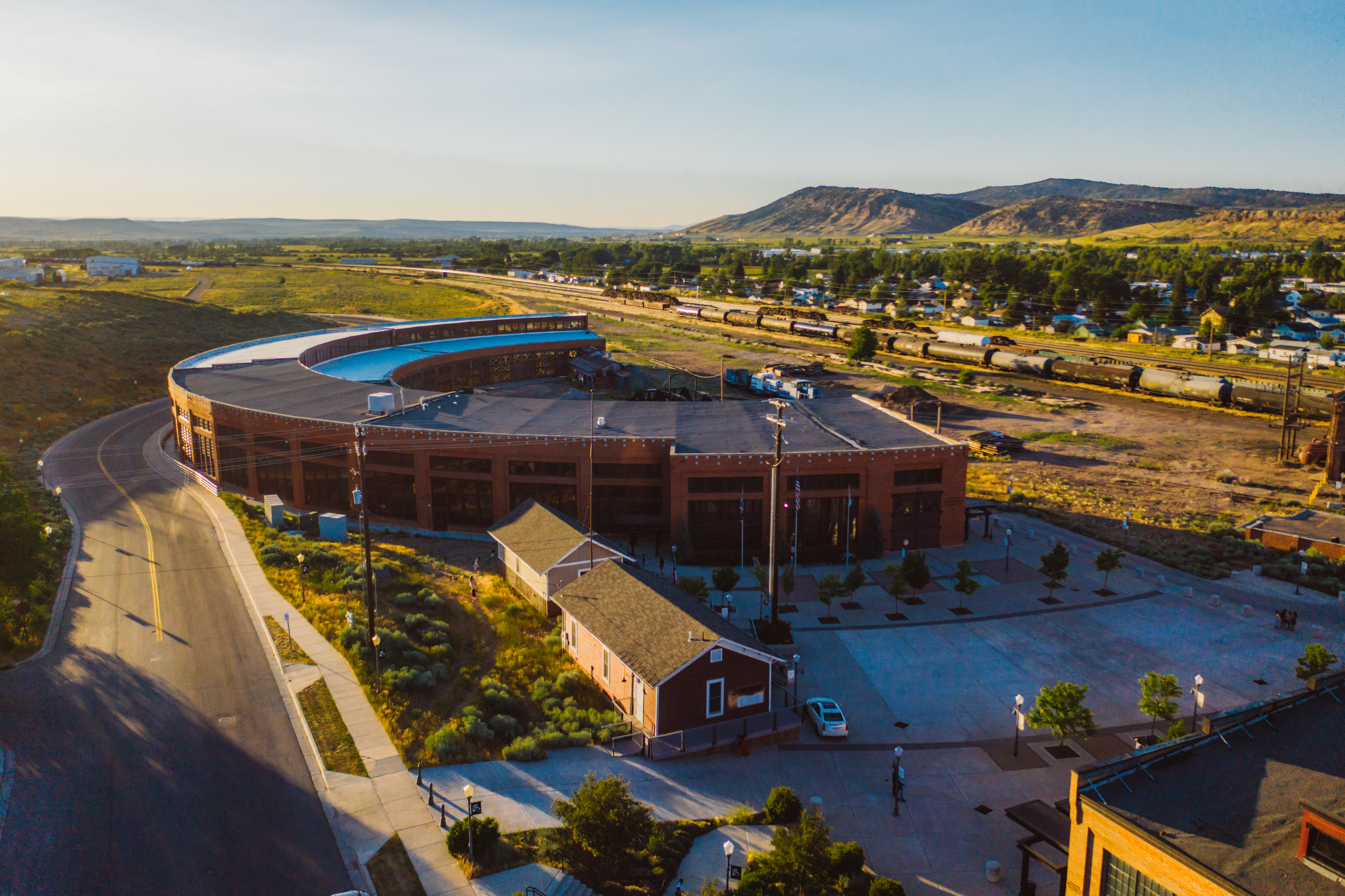
The Union Pacific Railroad Complex in Evanston, Wyoming, was built to serve the Union Pacific Railroad main line running through Evanston. The complex's brick buildings were built in 1912–13, with frame buildings spanning the period from 1871 to the 1920s. The complex features a roundhouse with 27 stalls built during the 1912 improvement phase, replacing an earlier roundhouse built in 1871. The complex was the chief service point on the UP main line between Ogden, Utah, and Green River, Wyoming. Five brick structures remain: the roundhouse, machine shop, gas building, storehouse and the mineral building. Five frame buildings include an office, a woodworking shop and a company store. The maintenance depot was closed and transferred to Green River in 1927. The Evanston complex became the Union Pacific Reclamation Plant, where rolling stock received heavy overhaul. It was the largest employer in Evanston, employing more than 300. The Union Pacific deeded the complex to Evanston i ... [...More Info...] [...Related Items...] OR: [Wikipedia] [Google] [Baidu] |
Interstate 80 In Wyoming
Interstate 80 (I-80) is a part of the Interstate Highway System that runs from San Francisco, California, to Teaneck, New Jersey. In Wyoming, the Interstate Highway runs from the Utah state line near Evanston east to the Nebraska state line in Pine Bluffs. I-80 connects Cheyenne, Wyoming's capital and largest city, with several smaller cities along the southern tier of Wyoming, including Evanston, Green River, Rock Springs, Rawlins, and Laramie. The highway also connects those cities with Salt Lake City to the west and Omaha to the east. In Cheyenne, I-80 intersects I-25 and has Wyoming's only auxiliary Interstate, I-180. The Interstate runs concurrently with US Highway 30 (US 30) for most of their courses in Wyoming. I-80 also has shorter concurrencies with US 189 near Evanston, US 191 near Rock Springs, and US 287 and Wyoming Highway 789 (WYO 789) near Rawlins. The Interstate has business loops through all six cities along its co ... [...More Info...] [...Related Items...] OR: [Wikipedia] [Google] [Baidu] |
Lincoln Highway
The Lincoln Highway is the first transcontinental highway in the United States and one of the first highways designed expressly for automobiles. Conceived in 1912 by Indiana entrepreneur Carl G. Fisher, and formally dedicated October 31, 1913, the Lincoln Highway runs coast-to-coast from Times Square in New York City west to Lincoln Park in San Francisco, originally through 13 states: New York, New Jersey, Pennsylvania, Ohio, Indiana, Illinois, Iowa, Nebraska, Colorado, Wyoming, Utah, Nevada, and California. In 1915, the "Colorado Loop" was removed, and in 1928, a realignment relocated the Lincoln Highway through the northern tip of West Virginia. Thus, there are a total of 14 states, 128 counties, and more than 700 cities, towns and villages through which the highway passed at some time in its history. The first officially recorded length of the entire Lincoln Highway in 1913 was . Over the years, the road was improved and numerous realignments were made, See throughout, bu ... [...More Info...] [...Related Items...] OR: [Wikipedia] [Google] [Baidu] |
Chinese Railroad Workers
The history of Chinese Americans or the history of Overseas Chinese, ethnic Chinese in the United States includes three major waves of Chinese emigration, Chinese immigration to the United States, beginning in the 19th century. Chinese immigrants in the 19th century worked in the California Gold Rush of the 1850s and the Central Pacific Railroad in the 1860s. They also worked as laborers in Western mines. They suffered Anti-Chinese sentiment in the United States, racial discrimination at every level of society. The white people were stirred to anger by the "Yellow Peril, yellow peril" rhetoric . Despite provisions for equal treatment of Chinese immigrants in the 1868 Burlingame Treaty between the US and China, political and labor organizations rallied against "cheap Chinese labor." Newspapers condemned employers who were initially pro-Chinese. When clergy ministering to the Chinese immigrants in California supported the Chinese, they were severely criticized by the local press ... [...More Info...] [...Related Items...] OR: [Wikipedia] [Google] [Baidu] |
Almy, Wyoming
Almy was a coal mining camp in Uinta County, Wyoming, United States, near the town of Evanston. In 1881, an explosion killed 38 miners in the Central Pacific Mine, marking the first mine explosion west of the Mississippi River. Another explosion killed 13 in 1886, and a third explosion in Red Canyon in 1895 killed 62 miners, the third worst mining disaster in Wyoming history. Following the second explosion, the Wyoming territorial legislature established the office of the state mining inspector, which eventually shut down the Almy mines in the 1940s after it was deemed too dangerous to mine there. 1881 explosion On March 4, 1881, gases in the Central Pacific Mine number 3 exploded, killing 38 miners. On March 10, the Cheyenne Weekly Leader reported the disaster:Historical Summary of Mine Disasters in the United States Volume 1 Coal Mines - 1810-1958, Mine Safety and Health Administration, 1998 A terrific explosion occurred last night between 9 and 10 o'clock in the Central ... [...More Info...] [...Related Items...] OR: [Wikipedia] [Google] [Baidu] |


