|
Evangelistas Lighthouse
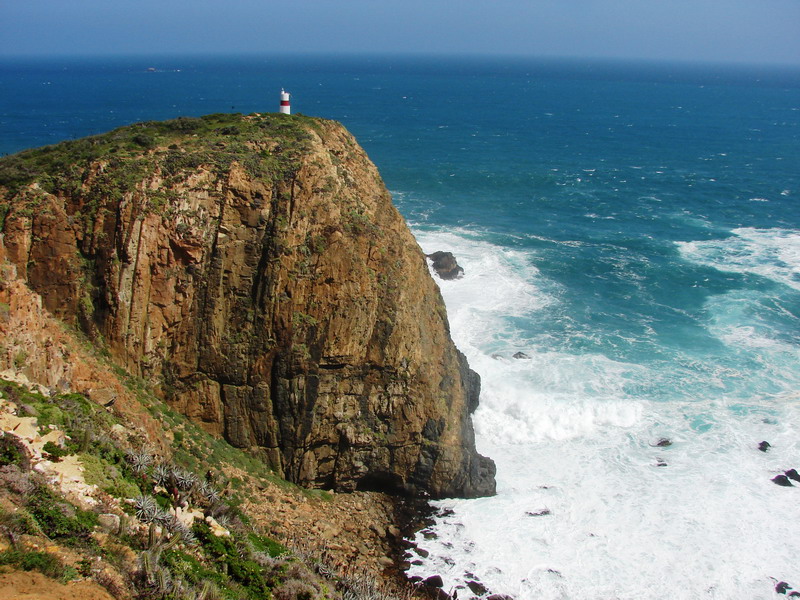
The Evangelistas Lighthouse () is one of the most exposed, isolated and least accessible in the world. Sited on the Evangelistas Islets on Chile's continental shelf in the south-eastern Pacific Ocean, it is the landfall light for ships crossing the Pacific eastwards to traverse the Strait of Magellan. A notable engineering accomplishment of its time, it was built by Scottish engineer George Henry Slight who had been recruited by Chilean President Jorge Montt, through the Chilean ambassador in London Agustin Ross, in order to establish a lighthouse service in Chile. Work on the lighthouse commenced on 30 April 1895. Slight's diary records his impressions of the Evangelistas on his arrival there: I never imagined seeing something so wild and desolate as those emerging dark rocks in the middle of the raging waves. To see these stormy craggy rocks was frightening. With a dim light on the horizon we could see large waves crashing heavily in the western part of the islands: a visio ... [...More Info...] [...Related Items...] OR: [Wikipedia] [Google] [Baidu] |
Evangelistas Islets
__NOTOC__ The Evangelistas Islets (Spanish: ''Islotes Evangelistas'') comprise a group of four small, rocky islands lying on the Chilean continental shelf, some 30 km north-west of the western entrance to the Strait of Magellan, in the south-eastern Pacific Ocean, facing the full force of the " Furious Fifties". They come under the jurisdiction of the Chilean Navy which operates the Chilean Maritime Signalling Service and has maintained a presence there since the establishment of the Evangelistas Lighthouse in 1896 by Scottish engineer George Henry Slight. On February 17, 1676, sixteen men of Pascual de Iriate's expedition were lost at Evangelistas Islets while attempting to install a bronze plaque indicating the areas ownership by the King of Spain. Description The largest of the group is ''Evangelistas Grande'' which is about long and wide, reaches a height of and supports the lighthouse. The other, uninhabited, islets are ''Elcano'' , ''Lobos'' , and ''Pan de Azúcar ... [...More Info...] [...Related Items...] OR: [Wikipedia] [Google] [Baidu] |
Chile
Chile, officially the Republic of Chile, is a country in the western part of South America. It is the southernmost country in the world, and the closest to Antarctica, occupying a long and narrow strip of land between the Andes to the east and the Pacific Ocean to the west. Chile covers an area of , with a population of 17.5 million as of 2017. It shares land borders with Peru to the north, Bolivia to the north-east, Argentina to the east, and the Drake Passage in the far south. Chile also controls the Pacific islands of Juan Fernández, Isla Salas y Gómez, Desventuradas, and Easter Island in Oceania. It also claims about of Antarctica under the Chilean Antarctic Territory. The country's capital and largest city is Santiago, and its national language is Spanish. Spain conquered and colonized the region in the mid-16th century, replacing Inca rule, but failing to conquer the independent Mapuche who inhabited what is now south-central Chile. In 1818, after declaring in ... [...More Info...] [...Related Items...] OR: [Wikipedia] [Google] [Baidu] |
Continental Shelf
A continental shelf is a portion of a continent that is submerged under an area of relatively shallow water, known as a shelf sea. Much of these shelves were exposed by drops in sea level during glacial periods. The shelf surrounding an island is known as an ''insular shelf''. The continental margin, between the continental shelf and the abyssal plain, comprises a steep continental slope, surrounded by the flatter continental rise, in which sediment from the continent above cascades down the slope and accumulates as a pile of sediment at the base of the slope. Extending as far as 500 km (310 mi) from the slope, it consists of thick sediments deposited by turbidity currents from the shelf and slope. The continental rise's gradient is intermediate between the gradients of the slope and the shelf. Under the United Nations Convention on the Law of the Sea, the name continental shelf was given a legal definition as the stretch of the seabed adjacent to the shores of a par ... [...More Info...] [...Related Items...] OR: [Wikipedia] [Google] [Baidu] |
Pacific Ocean
The Pacific Ocean is the largest and deepest of Earth's five oceanic divisions. It extends from the Arctic Ocean in the north to the Southern Ocean (or, depending on definition, to Antarctica) in the south, and is bounded by the continents of Asia and Oceania in the west and the Americas in the east. At in area (as defined with a southern Antarctic border), this largest division of the World Ocean—and, in turn, the hydrosphere—covers about 46% of Earth's water surface and about 32% of its total surface area, larger than Earth's entire land area combined .Pacific Ocean . '' Britannica Concise.'' 2008: Encyclopædia Britannica, Inc. The centers of both the |
Strait Of Magellan
The Strait of Magellan (), also called the Straits of Magellan, is a navigable sea route in southern Chile separating mainland South America to the north and Tierra del Fuego to the south. The strait is considered the most important natural passage between the Atlantic and Pacific oceans. It was discovered and first traversed by the Spanish expedition of Ferdinand Magellan in 1520, after whom it is named. Prior to this, the strait had been navigated by canoe-faring indigenous peoples including the Kawésqar. Magellan's original name for the strait was ''Estrecho de Todos los Santos'' ("Strait of All Saints"). The King of Spain, Emperor Charles V, who sponsored the Magellan-Elcano expedition, changed the name to the Strait of Magellan in honor of Magellan. The route is difficult to navigate due to frequent narrows and unpredictable winds and currents. Maritime piloting is now compulsory. The strait is shorter and more sheltered than the Drake Passage, the often stormy open sea ... [...More Info...] [...Related Items...] OR: [Wikipedia] [Google] [Baidu] |
George Henry Slight
George Henry Slight (30 September 1859 – 26 June 1934) was a Scottish engineer who established the Chilean lighthouse service. Early years Slight, the son of George Slight and Elizabeth Marshall, grew up in Edinburgh in an engineering family. After an apprenticeship as a mechanical engineer, he worked on the steamers plying the route between Britain and India. He subsequently worked for several years with Trinity House, which was responsible for the lighthouse service in England and Wales. Chile In 1893 Slight was recruited by the Chilean ambassador in London, Agustin Ross, who had been ordered by the President of Chile, Jorge Montt, to find someone suitable to establish a system of lighthouses in the country. Slight's first task on arrival in Chile was to build a lighthouse on the Evangelistas Islets at the western entrance to the Strait of Magellan in the southern part of the country, which he accomplished when the Evangelistas Lighthouse was completed in 1896. Sli ... [...More Info...] [...Related Items...] OR: [Wikipedia] [Google] [Baidu] |
Jorge Montt
Jorge Montt Álvarez (; April 26, 1845 – October 8, 1922) was a vice admiral in the Chilean Navy and president of Chile from 1891 to 1896.L.S. Rowe, "Passing of a Great Figure in Chilean History." ''Bulletin Pan American Union'' 55 (1922): 481+. Early life Born in Casablanca, Chile, He was a nephew of previous Chilean president Manuel Montt, and a cousin of future president Pedro Montt. After graduating from the naval academy in 1861, he served in the Chincha Islands War (1864-1866) and the War of the Pacific (1879-1883). He led the 1891 Chilean Civil War against President José Manuel Balmaceda to become provisional leader and eventually president in 1891. Presidency The close of the revolution against Balmaceda left the government of Chile in the hands of the junta under whose guidance the military and naval operations had been organized. Admiral Jorge Montt had been the head of this revolutionary committee, and he acted as president of the provisional government when ... [...More Info...] [...Related Items...] OR: [Wikipedia] [Google] [Baidu] |
Lighthouses In Chile
Chile has a large and intricate coastline of 4000 km with myriads of islands, islets, straits, bays, and fjords. Moreover, three waterways between the Pacific Ocean and the Atlantic Ocean, namely the Strait of Magellan, the Beagle Channel and the Drake Passage, pass the Chilean coasts. In order to mark dangerous coastlines, hazardous shoals, reefs, and safe entries to harbors, the Chilean authorities maintain 650 lighthouses from the border with Peru to the Atlantic ocean. History On 18 September 1857, the first lighthouse in Chile, the "Faro Angeles", was inaugurated in Valparaíso. In 1867, the Dane Enrique Siemsen was appointed chief of the "Servicio de Faros". He built the ''Faro Corona'' in Ancud, ''Punta Caldera'' in Atacama, ''Punta Tortugas'' in Coquimbo, ''Isla Quiriquina'' in Quiriquina, ''Punta Galera'' and ''Punta Niebla'' in Corral. The first lighthouses in Chile used colza oil as fuel, but in 1878 it was replaced by Bunsen burners. George Slight designed and ... [...More Info...] [...Related Items...] OR: [Wikipedia] [Google] [Baidu] |
Croatia
, image_flag = Flag of Croatia.svg , image_coat = Coat of arms of Croatia.svg , anthem = "Lijepa naša domovino"("Our Beautiful Homeland") , image_map = , map_caption = , capital = Zagreb , coordinates = , largest_city = capital , official_languages = Croatian , languages_type = Writing system , languages = Latin , ethnic_groups = , ethnic_groups_year = 2021 , religion = , religion_year = 2021 , demonym = , government_type = Unitary parliamentary republic , leader_title1 = President , leader_name1 = Zoran Milanović , leader_title2 = Prime Minister , leader_name2 = Andrej Plenković , leader_title3 = Speaker of Parliament , leader_name3 = Gordan Jandroković , legislature = Sabor , sovereignty_type ... [...More Info...] [...Related Items...] OR: [Wikipedia] [Google] [Baidu] |
Chiloé Archipelago
The Chiloé Archipelago ( es, Archipiélago de Chiloé, , ) is a group of islands lying off the coast of Chile, in the Los Lagos Region. It is separated from mainland Chile by the Chacao Channel in the north, the Sea of Chiloé in the east and the Gulf of Corcovado in the southeast. All islands except the Desertores Islands form Chiloé Province. The main island is Chiloé Island. Of roughly rectangular shape, the southwestern half of this island is a wilderness of contiguous forests, wetlands and, in some places, mountains. The landscape of the northeastern sectors of Chiloé Island and the islands to the east is dominated by rolling hills, with a mosaic of pastures, forests and cultivated fields. The archipelago is known within Chile for its distinctive folklore, mythology, potatoes, cuisine and unique architecture. The culture of Chiloé is the result of mixing of Huilliche, Spanish and Chono influences in centuries of isolation without much contact with the rest of Chile o ... [...More Info...] [...Related Items...] OR: [Wikipedia] [Google] [Baidu] |
United States Hydrographic Office
The United States Hydrographic Office prepared and published maps, charts, and nautical books required in navigation. The office was established by an act of 21 June 1866 as part of the Bureau of Navigation, Department of the Navy. It was transferred to the Department of Defense on 10 August 1949. The office was abolished on 10 July 1962, replaced by the Naval Oceanographic Office. Objectives Before the hydrographic office was established in 1866, U.S. navigators were almost entirely dependent on British charts. A few private enterprises had prepared and published charts, but had not been able to do so profitably. The Hydrographic Office was established "for the improvement of the means for navigating safely the vessels of the Navy and of the mercantile marine, by providing, under the authority of the Secretary of the Navy, accurate and cheap nautical charts, sailing directions, navigators and manuals of instructions for the use of all vessels of the United States, and for the ben ... [...More Info...] [...Related Items...] OR: [Wikipedia] [Google] [Baidu] |


.jpg)


