|
Erie Triangle
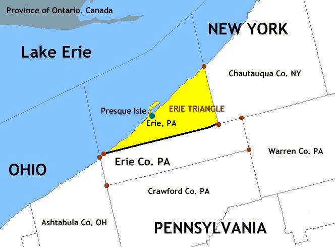
The Erie Triangle is a roughly 300-square-mile (780-square-kilometre) tract of American land that was the subject of several competing colonial-era claims. It was eventually acquired by the U.S. federal government and sold to Pennsylvania so that the state would have access to a freshwater port on Lake Erie. The Erie Triangle land makes up a large portion of present-day Erie County, Pennsylvania. Background Most of northwestern Pennsylvania came under American control following the 1784 Treaty of Fort Stanwix with the Iroquois Confederacy. The following year, a boundary dispute between New York and Pennsylvania erupted. Following a surveying effort by Andrew Ellicott representing the Pennsylvanians and James Clinton and Simeon DeWitt representing the New Yorkers, the western edge of New York was set at east of Pennsylvania's Presque Isle, a small peninsula off the coast of Erie, Pennsylvania. However, this left an unclaimed area, which came to be known as the Triangle Lands ... [...More Info...] [...Related Items...] OR: [Wikipedia] [Google] [Baidu] |
Erie Triangle Map 2
Erie (; ) is a city on the south shore of Lake Erie and the county seat of Erie County, Pennsylvania, United States. Erie is the List of cities and boroughs in Pennsylvania by population, fifth largest city in Pennsylvania and the largest city in Northwestern Pennsylvania with a population of 94,831 at the 2020 United States census, 2020 census. The estimated population in 2021 had decreased to 93,928. The Erie-Meadville, PA Combined Statistical Area, Erie metropolitan area, equivalent to all of Erie County, Pennsylvania, Erie County, consists of 266,096 residents. The Erie-Meadville, PA Combined Statistical Area, Erie-Meadville combined statistical area had a population of 369,331 at the 2010 census. Erie is roughly equidistant from Buffalo, New York, Buffalo and Cleveland, each being about 100 miles (160 kilometers) away. Erie's manufacturing sector remains prominent in the local economy, though insurance, healthcare, higher education, technology, service industries, and touri ... [...More Info...] [...Related Items...] OR: [Wikipedia] [Google] [Baidu] |
Iroquois
The Iroquois ( or ), officially the Haudenosaunee ( meaning "people of the longhouse"), are an Iroquoian-speaking confederacy of First Nations peoples in northeast North America/ Turtle Island. They were known during the colonial years to the French as the Iroquois League, and later as the Iroquois Confederacy. The English called them the Five Nations, comprising the Mohawk, Oneida, Onondaga, Cayuga, and Seneca (listed geographically from east to west). After 1722, the Iroquoian-speaking Tuscarora people from the southeast were accepted into the confederacy, which became known as the Six Nations. The Confederacy came about as a result of the Great Law of Peace, said to have been composed by Deganawidah the Great Peacemaker, Hiawatha, and Jigonsaseh the Mother of Nations. For nearly 200 years, the Six Nations/Haudenosaunee Confederacy were a powerful factor in North American colonial policy, with some scholars arguing for the concept of the Middle Ground, in that Eu ... [...More Info...] [...Related Items...] OR: [Wikipedia] [Google] [Baidu] |
Northern Tier (Pennsylvania)
The Northern Tier is a geographic region consisting of five rural counties in north-central Pennsylvania. Geography The region is bordered to the north by the Southern Tier of New York state. Together, these regions are known as the Twin Tiers. The counties and important towns in the Northern Tier are: * Bradford **Athens ** Sayre ** Towanda *Sullivan ** Dushore ** Laporte * Susquehanna ** Forest City ** Montrose ** New Milford *Tioga **Mansfield ** Wellsboro *Wyoming **Tunkhannock The region is bounded to the north by the Southern Tier of New York, to the west by Northern Pennsylvania, and to the east by Northeastern Pennsylvania. Population The five Northern Tier counties are home to roughly 180,000 people distributed among many small towns and the countryside. The largest town is Sayre which is located on the left-east bank of the North Branch Susquehanna River and is on Interstate 86 where it dips just south of the New York state line. Transportation U.S. Rout ... [...More Info...] [...Related Items...] OR: [Wikipedia] [Google] [Baidu] |
Twin Tiers
The Twin Tiers are the collective counties that lie on the New York-Pennsylvania border on either side of the 42nd parallel north. The region is predominantly rural and contains many small towns. Separately, the two halves of the Twin Tiers region are known as the Southern Tier region in the state of New York and the Northern Tier region in the Commonwealth of Pennsylvania. The "Northern" and "Southern" designations are relative to the states in which they are located, not relative to each other. Constituent counties The Twin Tiers region is usually defined as including these counties: McKean, Potter, and (less often) Cameron Counties refer to themselves as part of the Twin Tiers, but almost never consider themselves part of the Northern Tier, instead going by the name "Northern Pennsylvania". Significant ambiguity often exists in regions: for instance, the western part of the region (McKean and Potter Counties) often associate themselves with St. Marys, a city larger than ... [...More Info...] [...Related Items...] OR: [Wikipedia] [Google] [Baidu] |
Ohio
Ohio () is a U.S. state, state in the Midwestern United States, Midwestern region of the United States. Of the List of states and territories of the United States, fifty U.S. states, it is the List of U.S. states and territories by area, 34th-largest by area, and with a population of nearly 11.8 million, is the List of U.S. states and territories by population, seventh-most populous and List of U.S. states and territories by population density, tenth-most densely populated. The state's capital and List of cities in Ohio, largest city is Columbus, Ohio, Columbus, with the Columbus metropolitan area, Ohio, Columbus metro area, Cincinnati metropolitan area, Greater Cincinnati, and Greater Cleveland being the List of metropolitan statistical areas, largest metropolitan areas. Ohio is bordered by Lake Erie to the north, Pennsylvania to the east, West Virginia to the southeast, Kentucky to the southwest, Indiana to the west, and Michigan to the northwest. Ohio is historically known as ... [...More Info...] [...Related Items...] OR: [Wikipedia] [Google] [Baidu] |
Lake Erie Islands
The Lake Erie Islands are a chain of archipelagic islands in Lake Erie. They include Kelleys Island, Erie Island, Pelee Island, the Bass Islands, and several others. The majority of these islands are under the sovereignty of the State of Ohio in the United States. Pelee Island is the only major inhabited island within the province of Ontario, while the smaller Middle Island is the southmost point of land in Canada. Most of the larger islands are popular tourist attractions, served by car ferries running from the mainland and between some islands. Some small airports and numerous private marinas offer other ways for visitors to reach the islands. Combined with nearby Sandusky and Port Clinton, Ohio, the islands are part of the collective area known regionally as " Vacationland". Geology The Lake Erie Islands are geologically part of the Silurian Columbus Limestone. When the Pleistocene ice sheets carved out the basin of modern-day Lake Erie, these hard rocks proved more ... [...More Info...] [...Related Items...] OR: [Wikipedia] [Google] [Baidu] |
War Of 1812
The War of 1812 (18 June 1812 – 17 February 1815) was fought by the United States of America and its indigenous allies against the United Kingdom and its allies in British North America, with limited participation by Spain in Florida. It began when the United States declared war on 18 June 1812 and, although peace terms were agreed upon in the December 1814 Treaty of Ghent, did not officially end until the peace treaty was ratified by Congress on 17 February 1815. Tensions originated in long-standing differences over territorial expansion in North America and British support for Native American tribes who opposed US colonial settlement in the Northwest Territory. These escalated in 1807 after the Royal Navy began enforcing tighter restrictions on American trade with France and press-ganged men they claimed as British subjects, even those with American citizenship certificates. Opinion in the US was split on how to respond, and although majorities in both the House an ... [...More Info...] [...Related Items...] OR: [Wikipedia] [Google] [Baidu] |
Battle Of Lake Erie
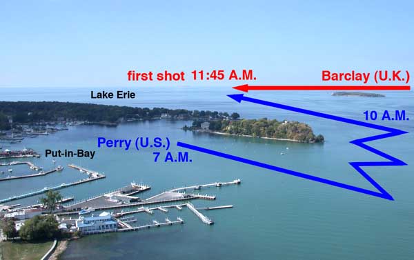
The Battle of Lake Erie, sometimes called the Battle of Put-in-Bay, was fought on 10 September 1813, on Lake Erie off the shore of Ohio during the War of 1812. Nine vessels of the United States Navy defeated and captured six vessels of the British Royal Navy. This ensured American control of the lake for the rest of the war, which in turn allowed the Americans to recover Detroit and win the Battle of the Thames to break the Native Americans in the United States, Indian confederation of Tecumseh. It was one of the biggest naval battles of the War of 1812. Background 1812 When the war broke out, the British immediately seized control of Lake Erie. They already had a small force of warships there: the sloop-of-war and the brig HMS Hunter (1812), ''General Hunter''. The schooner was under construction and was put into service a few weeks after the outbreak of war. These vessels were controlled by the Canadian Units of the War of 1812#The Provincial Marine, Provincial Marine, w ... [...More Info...] [...Related Items...] OR: [Wikipedia] [Google] [Baidu] |
List Of U
A ''list'' is any set of items in a row. List or lists may also refer to: People * List (surname) Organizations * List College, an undergraduate division of the Jewish Theological Seminary of America * SC Germania List, German rugby union club Other uses * Angle of list, the leaning to either port or starboard of a ship * List (information), an ordered collection of pieces of information ** List (abstract data type) In computer science, a list or sequence is an abstract data type that represents a finite number of ordered values, where the same value may occur more than once. An instance of a list is a computer representation of the mathematical concept of ..., a method to organize data in computer science * List on Sylt, previously called List, the northernmost village in Germany, on the island of Sylt * ''List'', an alternative term for ''roll'' in flight dynamics * To ''list'' a building, etc., in the UK it means to designate it a listed building that may not ... [...More Info...] [...Related Items...] OR: [Wikipedia] [Google] [Baidu] |
Northwest Ordinance
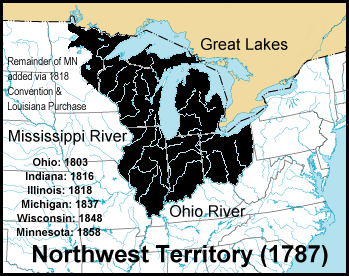
The Northwest Ordinance (formally An Ordinance for the Government of the Territory of the United States, North-West of the River Ohio and also known as the Ordinance of 1787), enacted July 13, 1787, was an organic act of the Congress of the Confederation of the United States. It created the Northwest Territory, the new nation's first organized incorporated territory, from lands beyond the Appalachian Mountains, between British North America and the Great Lakes to the north and the Ohio River to the south. The upper Mississippi River formed the territory's western boundary. Pennsylvania was the eastern boundary. In the 1783 Treaty of Paris, which formally ended the American Revolutionary War, Great Britain yielded the region to the United States. However, the Confederation Congress faced numerous problems gaining control of the land such as the unsanctioned movement of American settlers into the Ohio Valley; violent confrontations with the region's indigenous peoples; the ... [...More Info...] [...Related Items...] OR: [Wikipedia] [Google] [Baidu] |
Surveyor General Of The Northwest Territory
The Surveyor General of the Northwest Territory was a United States government official responsible for surveying land in the Northwest Territory in the United States late in the late eighteenth and early nineteenth century. The position was created in the Land Act of 1796 - Text of Act of May 18, 1796 Library of Congress to survey lands ceded by Native Americans northwest of the Ohio River and above the mouth of the Kentucky River. This act, and those that followed evolved into the Public Land Survey System. Rufus Putnam was appointed to the office in 1797, and held it until 1803. His office was in Marietta. In 1801, the position was offered to Andrew Ellicott by Thomas Jefferson, but he refused, because he was upset at slow pay for work he had done for the federal government. Jared Mansfield held the office from 1803 to 1813. His office was in Cincinnati. Josiah Meigs held office 1813 to 1815, and Edward Tiffin from 1815 to his death in 1829. Tiffin had his office in ... [...More Info...] [...Related Items...] OR: [Wikipedia] [Google] [Baidu] |
Beginning Point Of The U
Beginning may refer to: * ''Beginning'' (album), by Pakho Chau * ''Beginning'' (play), a 2017 play by David Eldridge * ''Beginning'' (film), a Georgian-French drama film *"Beginning", a song by heavy metal band Kotipelto *"Beginning", a 2018 track by Toby Fox from ''Deltarune Chapter 1 OST'' from the video game ''Deltarune'' See also * Begin (other) *Beginnings (other) *In the Beginning (other) In the Beginning may refer to: Biblical phrase * "In the beginning" (phrase), a phrase in the Bible verses of Genesis 1:1 and John 1:1 Books * ''In the Beginning'' (novel), a novel by Chaim Potok * ''In the Beginning'', a 2004 story arc and col ... * The Beginning (other) {{disambiguation ... [...More Info...] [...Related Items...] OR: [Wikipedia] [Google] [Baidu] |


