|
Erdapfel
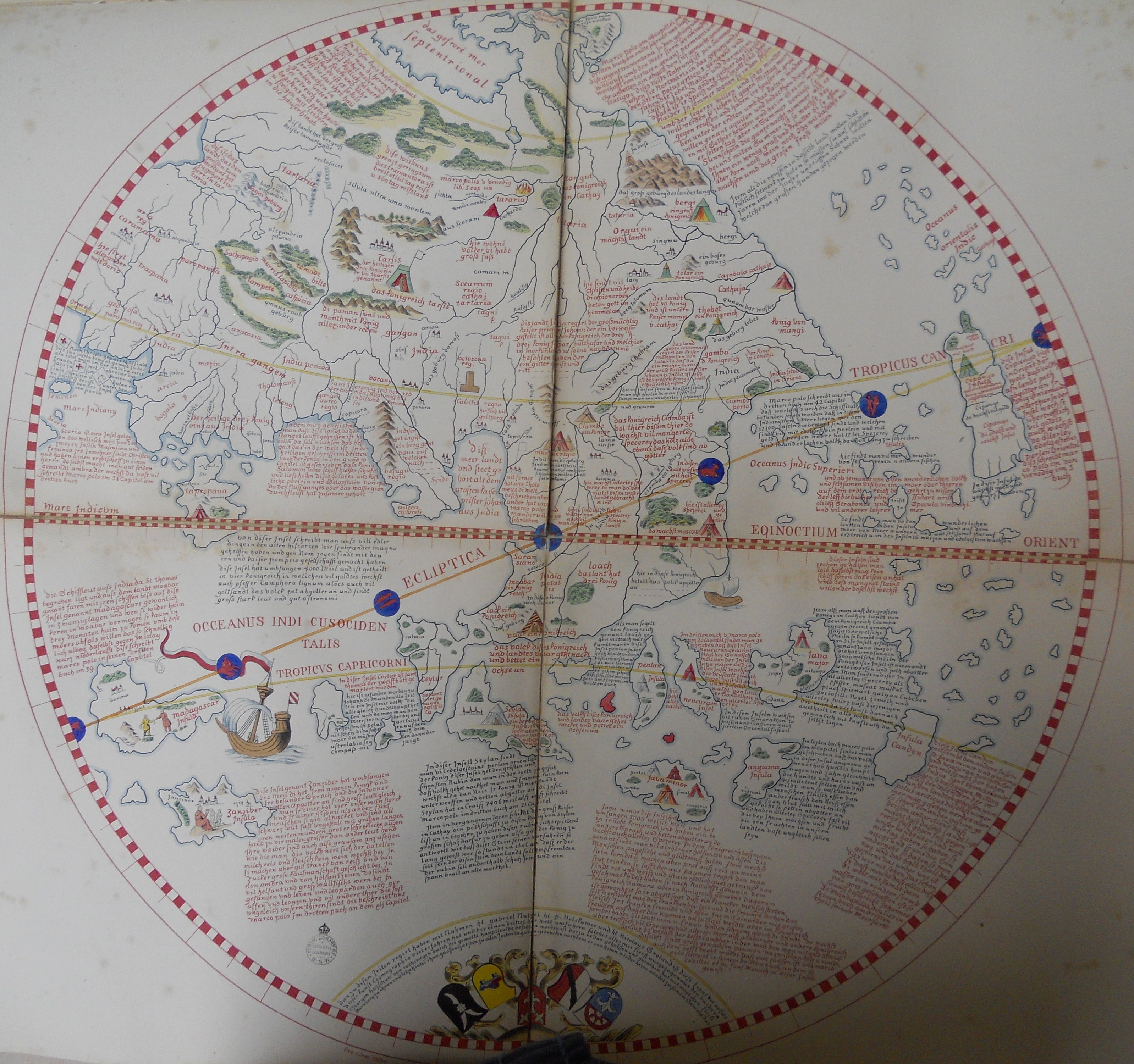
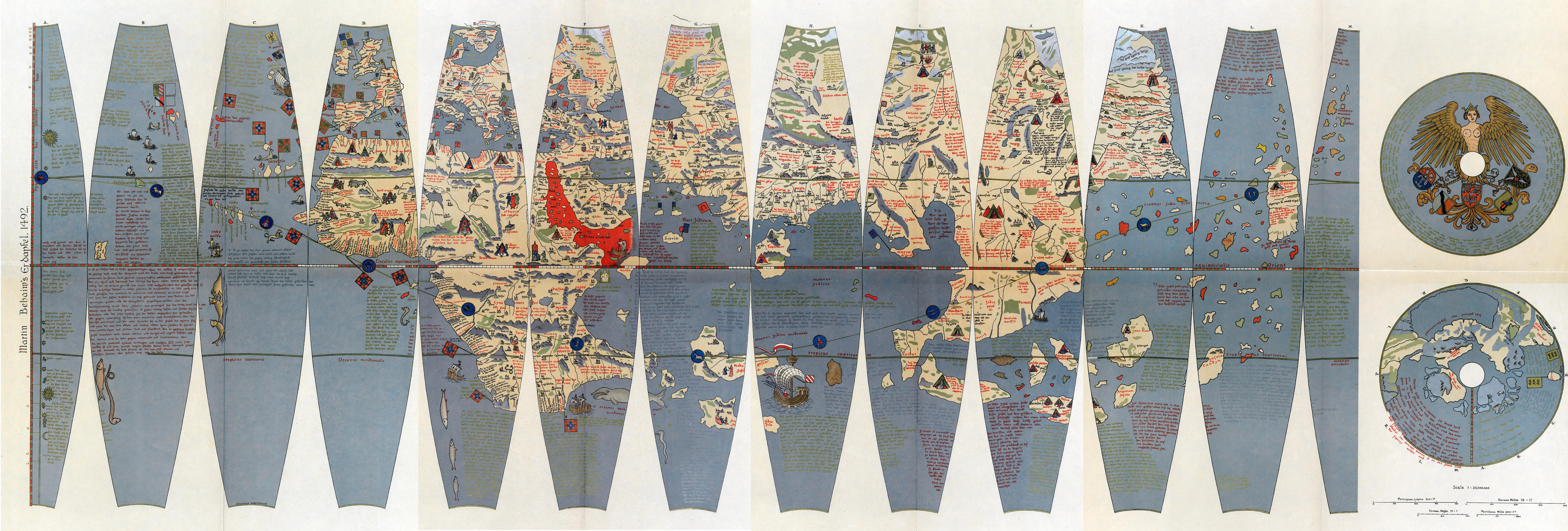
__NOTOC__ The (; ) is a terrestrial globe produced by Martin Behaim from 1490–1492. The Erdapfel is the oldest surviving terrestrial globe. It is constructed of a laminated linen ball in two halves, reinforced with wood and overlaid with a map painted on gores by Georg Glockendon. The map was drawn on paper, which was pasted on a layer of parchment around the globe. The Americas are not included, as Columbus returned to Spain no sooner than March 1493. The globe shows an enlarged Eurasian continent and an empty ocean between Europe and Asia. The mythical Saint Brendan's Island is included. Cipangu ( Japan) is oversized and well south of its true position; Martellus's map is followed in developing an enormous phantom peninsula east of the Golden Chersonese (Malaysia). The idea to call the globe "apple" may be related to the Reichsapfel ("Imperial Apple", Globus cruciger) which was also kept in Nuremberg along with the Imperial Regalia ( Reichskleinodien). The name is no ... [...More Info...] [...Related Items...] OR: [Wikipedia] [Google] [Baidu] |
Early World Maps
The earliest known world maps date to classical antiquity, the oldest examples of the 6th to 5th centuries BCE still based on the flat Earth paradigm. World maps assuming a spherical Earth first appear in the Hellenistic period. The developments of Greek geography during this time, notably by Eratosthenes and Posidonius culminated in the Roman era, with Ptolemy's world map (2nd century CE), which would remain authoritative throughout the Middle Ages. Since Ptolemy, knowledge of the approximate size of the Earth allowed cartographers to estimate the extent of their geographical knowledge, and to indicate parts of the planet known to exist but not yet explored as '' terra incognita''. With the Age of Discovery, during the 15th to 18th centuries, world maps became increasingly accurate; exploration of Antarctica, Australia, and the interior of Africa by western mapmakers was left to the 19th and early 20th century. Antiquity Bronze Age “Saint-Bélec slab” The Saint-Bélec s ... [...More Info...] [...Related Items...] OR: [Wikipedia] [Google] [Baidu] |
Martin Behaim
Martin Behaim (6 October 1459 – 29 July 1507), also known as and by various forms of , was a German textile merchant and cartographer. He served John II of Portugal as an adviser in matters of navigation and participated in a voyage to West Africa. He is now best known for his Erdapfel, the world's oldest surviving globe, which he produced for the Imperial City of Nuremberg in 1492. Biography Behaim was born in Nuremberg on 6 October 1459, the oldest son of Martin Behaim and Agnes Schopper. The elder Martin was a merchant involved in long-distance trade within Europe, including Venice; in 1461 he was elected a senator of Nuremberg. Their son, as a member of a prominent and prosperous family, likely received a good education at one of the best grammar schools in the city. Contrary to later assertions, it is unlikely that he was ever a student of the famous Renaissance mathematician and astronomer, Regiomontanus.Görz, 2007Ravenstein, 1908 When his father died in 147 ... [...More Info...] [...Related Items...] OR: [Wikipedia] [Google] [Baidu] |
Globe
A globe is a spherical model of Earth, of some other celestial body, or of the celestial sphere. Globes serve purposes similar to maps, but unlike maps, they do not distort the surface that they portray except to scale it down. A model globe of Earth is called a terrestrial globe. A model globe of the celestial sphere is called a '' celestial globe''. A globe shows details of its subject. A terrestrial globe shows landmasses and water bodies. It might show nations and major cities and the network of latitude and longitude lines. Some have raised relief to show mountains and other large landforms. A celestial globe shows notable stars, and may also show positions of other prominent astronomical objects. Typically, it will also divide the celestial sphere into constellations. The word ''globe'' comes from the Latin word ''globus'', meaning "sphere". Globes have a long history. The first known mention of a globe is from Strabo, describing the Globe of Crates from about ... [...More Info...] [...Related Items...] OR: [Wikipedia] [Google] [Baidu] |
Dragon's Tail (peninsula)
The Dragon's Tail is a modern name for the phantom peninsula in southeast Asia which appeared in medieval Arabian and Renaissance European world maps. It formed the eastern shore of the Great Gulf (Gulf of Thailand) east of the Golden Chersonese (Malay Peninsula), replacing the " unknown lands" which Ptolemy and others had thought surrounded the " Indian Sea". Name The peninsula known to modern cartographers as the "Dragon's Tail" or "Tiger's Tail" appeared under various names on different maps. History Early history The peninsula does not appear in any surviving manuscript of Ptolemy's ''Geography'' or other Greek geographers. Instead, it is first attested in the Ptolemaic-influenced '' Book of the Description of the Earth'' compiled by al-Khwārizmī around 833 AD. Ptolemy's map ended at 180°E of the Fortunate Isles without being able to explain what might lie on the imagined eastern shore of the Indian Ocean or beyond the lands of the Sinae and of Serica in Asia. ... [...More Info...] [...Related Items...] OR: [Wikipedia] [Google] [Baidu] |
Names Of Japan
The word '' Japan'' is an exonym, and is used (in one form or another) by many languages. The Japanese names for Japan are Nippon () and Nihon (). They are both written in Japanese using the kanji . During the third-century CE Three Kingdoms period, Japan was inhabited by the Yayoi people who lived in Kyushu up to the Kanto region. They were called ''Wa'' in Chinese, and the kanji for their name can be translated as "dwarf" or "submissive". Japanese scribes found fault with its offensive connotation, and officially changed the characters they used to spell the native name for Japan, ''Yamato'', replacing the ("dwarf") character for ''Wa'' with the homophone ("peaceful, harmonious"). ''Wa'' was often combined with ("great") to form the name , which is read as ''Yamato'' (see also Jukujikun for a discussion of this type of spelling where the kanji and pronunciations are not directly related). The earliest record of appears in the Chinese '' Old Book of Tang'', which notes ... [...More Info...] [...Related Items...] OR: [Wikipedia] [Google] [Baidu] |
Georg Glockendon
Georg Glockendon the Elder (fl. 1484; died 1514) was a Nuremberg-based woodblock cutter, printer and painter. Famed during his lifetime for his illuminations, he was also an industrious printer and published a number of the works of Erhard Etzlaub. The Erdapfel of Martin Behaim is the best known of his painted works, the majority of which remain unidentified. As a member of the Glockendon family of artists, he was the father of miniaturist and woodcutter Albrecht Albrecht ("noble", "bright") is a given name or surname of German origin and may refer to: First name *Albrecht Agthe, (1790–1873), German music teacher *Albrecht Altdorfer, (c. 1480–1538) German Renaissance painter *Albrecht Becker, (1906� ..., who took over the family workshop, and master illuminator Nikolaus. References *Smith, Jeffrey Chipps"Glockendon."In Grove Art Online. Oxford Art Online, (accessed February 3, 2012; subscription required). * External linksEntry for Georg Glockendon the Elderon the ... [...More Info...] [...Related Items...] OR: [Wikipedia] [Google] [Baidu] |
Ostrich Egg Globe
The Ostrich Egg Globe is a hollow terrestrial globe made from the conjoined lower halves of two ostrich eggs. The owner of the globe claims that it was made in the early 16th century and is the first globe to depict the New World (with North America only shown as small islands). The carvings on the globe are similar to those on the Hunt–Lenox Globe, a red copper cast. Provenance The globe was offered for sale in 2012 at the London Map Fair held at the Royal Geographical Society. Its similarity to the Lenox Globe was confirmed by the former president of the Coronelli Society, Professor Rudolf Schmidt, and confirmed by art expert Archduke Dr. Géza von Habsburg in 2013. The owner of the globe, Stefaan Missinne, has written a book that argues that the globe was made by Leonardo da Vinci, citing writings by Leonardo indicating a similar approach to making globe gores. Cartographer Wouter Bracke states that Missine's book should be considered "a report on the author's research ... [...More Info...] [...Related Items...] OR: [Wikipedia] [Google] [Baidu] |
Saint Brendan's Island
Saint Brendan's Island, also known as Saint Brendan's Isle, is a phantom island or mythical island, supposedly situated in the North Atlantic somewhere west of Northern Africa. It is named after Saint Brendan of Clonfert. He and his followers are said to have discovered it while travelling across the ocean and evangelising its islands. It appeared on numerous maps in Christopher Columbus's time, most notably Martin Behaim's Erdapfel of 1492. It is known as ''La isla de San Borondón'' and ''isla de Samborombón'' in Spanish. The first mention of the island was in the Latin text ''Navigatio Sancti Brendani Abbatis'' ("''Voyage of Saint Brendan the Abbot''") of the ninth century, which inserted the island into Irish and European folklore. History Middle Ages This island is named after Saint Brendan, who claimed to have landed on it in AD 512 with 14 monks, with whom he celebrated a Mass. The monastic party reported its stay as 15 days, while the ships that expected their return co ... [...More Info...] [...Related Items...] OR: [Wikipedia] [Google] [Baidu] |
Germanisches Nationalmuseum
The Germanisches National Museum is a museum in Nuremberg, Germany. Founded in 1852, it houses a large collection of items relating to German culture and art extending from prehistoric times through to the present day. The Germanisches National Museum is Germany's largest museum of cultural history. Out of its total holding of some 1.3 million objects (including the holdings of the library and the Department of Prints and Drawings), approximately 25,000 are exhibited. The museum is situated in the south of the historic city center between Kornmarkt and Frauentormauer along the medieval city wall. Its entrance hall is situated on Kartäusergasse which was transformed by the Israeli sculptor Dani Karavan to the Way of Human Rights (german: Straße der Menschenrechte). Name, establishment, guiding principles The Germanisches Museum, as it was named initially, was founded by a group of individuals led by the Franconian baron Hans von und zu Aufsess, whose goal was to assembl ... [...More Info...] [...Related Items...] OR: [Wikipedia] [Google] [Baidu] |
Henricus Martellus Germanus
Henricus Martellus Germanus ( fl. 1480-1496) was a German cartographer active in Florence between 1480 and 1496. His surviving cartographic work includes manuscripts of Ptolemy's ''Geographia'', manuscripts of ''Insularium illustratum'' (a descriptive atlas of island maps), and two world maps which were the first to show a passage around the southern tip of Africa into the Indian Ocean. His world maps summarize geographical knowledge at the outset of the Age of Discovery and "epitomize the best of European cartography at the end of the fifteenth century." Biography Very little is known about the life of Henricus Martellus Germanus. Even his name and place of birth have been the subject of much speculation. In the fifteenth century it was common for scholars and artisans to adopt a Latinized version of their birth name. This was the case with Martellus. ''Germanus'' is the Latin word for Germany and it is the clearest indication of his origin. Some authors have assumed his birth na ... [...More Info...] [...Related Items...] OR: [Wikipedia] [Google] [Baidu] |
Golden Chersonese
The Golden Chersonese or Golden Khersonese ( grc, Χρυσῆ Χερσόνησος, ''Chrysḗ Chersónēsos''; la, Chersonesus Aurea), meaning the Golden Peninsula, was the name used for the Malay Peninsula by Greek and Roman geographers in classical antiquity, most famously in Claudius Ptolemy's 2nd-century ''Geography''. Name The earliest references to a fabulous land of gold that could be interpreted as places in South East Asia may be found in Indian literature. In ''Ramayana'', there are mentions of '' Suvarnabhumi'' (Land of Gold) and '' Suvarnadvipa'' (the Golden Island or Peninsula, where ''dvipa'' might refer to either a peninsula or an island) Greek knowledge of lands further to their east improved after the conquests of Alexander the Great, but specific references to places in South East Asia did not appear until after the rise of the Roman Empire. Greek and Roman geographers Eratosthenes, Dionysius Periegetes, and Pomponius Mela had written about a Golden Isle (''K ... [...More Info...] [...Related Items...] OR: [Wikipedia] [Google] [Baidu] |
TU Wien
TU Wien (TUW; german: Technische Universität Wien; still known in English as the Vienna University of Technology from 1975–2014) is one of the major universities in Vienna, Austria. The university finds high international and domestic recognition in teaching as well as in research, and it is a highly esteemed partner of innovation-oriented enterprises. It currently has about 28,100 students (29% women), eight faculties and about 5,000 staff members (3,800 academics). The university's teaching and research is focused on engineering, computer science, and natural sciences. History The institution was founded in 1815 by Emperor Francis I of Austria as the '' k.k. Polytechnische Institut'' (Imperial-Royal Polytechnic Institute). The first rector was Johann Joseph von Prechtl. It was renamed the ''Technische Hochschule'' (College of Technology) in 1872. When it began granting doctoral and higher degrees in 1975, it was renamed the ''Technische Universität Wien'' (Vienna Unive ... [...More Info...] [...Related Items...] OR: [Wikipedia] [Google] [Baidu] |


