|
Engineer Mountain
Engineer Mountain is a mountain summit located in San Juan County, Colorado, United States. It is part of the San Juan Mountains range which is a subset of the Rocky Mountains, and is west of the Continental Divide. Engineer Mountain is a prominent landmark set 1.5 mile immediately west of Coal Bank Pass, and is visible from multiple viewpoints along Highway 550, making it one of the most photographed mountains in the San Juans.J. D. Tanner, Emily Ressler-Tanner, ''Hiking the Four Corners: A Guide to the Area's Greatest Hiking Adventures'', 2015, Falcon Guides, , page 45. It is situated 11 miles southwest of the community of Silverton, on land managed by San Juan National Forest. Topographic relief is significant as the southwest aspect rises above Cascade Creek in approximately two miles. Neighbors include Snowdon Peak seven miles to the east, and Twilight Peak, five miles to the southeast. Climate According to the Köppen climate classification system, Engineer Moun ... [...More Info...] [...Related Items...] OR: [Wikipedia] [Google] [Baidu] |
San Juan National Forest
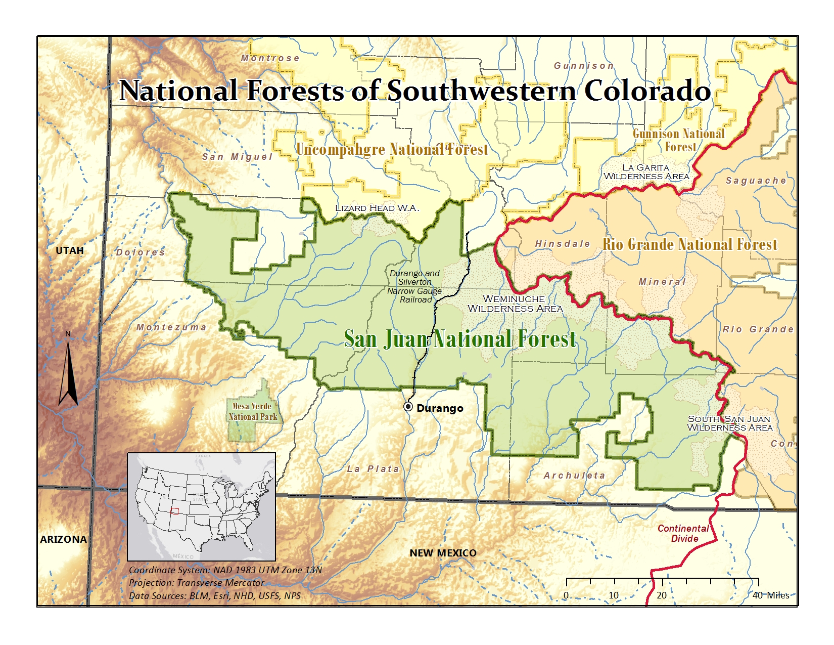
The San Juan National Forest is a U.S. National Forest covering over 1,878,846 acres (2,935.7 sq mi, or 7,603.42 km²) in western Colorado. The forest occupies land in Archuleta, Conejos, Dolores, Hinsdale, La Plata, Mineral, Montezuma, Rio Grande, San Miguel and San Juan Counties. It borders the Uncompahgre National Forest to the north and the Rio Grande National Forest to the east. The forest covers most of the southern portion of the San Juan Mountains west of the Continental Divide. The forest contains two alpine wilderness areas; the Weminuche and South San Juan, as well as the Piedra Area. The Durango and Silverton Narrow Gauge Railroad passes through the National Forest. The name of the forest comes from the San Juan River, which was originally called the Rio San Juan, after Saint John the Baptist (San Juan Bautista in Spanish). History Theodore Roosevelt created the forest by proclamation on June 3, 1905. Forest headquarters are located in Durango ... [...More Info...] [...Related Items...] OR: [Wikipedia] [Google] [Baidu] |
Twilight Peak
Twilight Peak is the highest summit of the West Needle Mountains range of the San Juan Mountains System in southwestern Colorado. The prominent peak is located in the Weminuche Wilderness of San Juan National Forest, south-southwest ( bearing 199°) of the Town of Silverton in San Juan County. Climbing The standard approach to Twilight Peak is via a trail from Molas Pass to the north. The trail leads to Crater Lake from where the summit is accessible. Adjacent to Twilight Peak are North Twilight Peak (13,075 feet) and South Twilight Peak (12,932 feet). See also *List of mountain peaks of Colorado This is a list of major mountain peaks in the U.S. State of Colorado. This article comprises three sortable tables of major mountain peaksThis article defines a significant summit as a summit with at least of topographic prominence, and a m ... * References External links Mountains of San Juan County, Colorado San Juan Mountains (Colorado) San Juan Nati ... [...More Info...] [...Related Items...] OR: [Wikipedia] [Google] [Baidu] |
Mountains Of Colorado
This list includes significant mountain peaks and high points located in the United States arranged alphabetically by state, district, or territory. The highest peak or point in each state, district or territory is noted in bold. Significant mountain peaks and high points Alabama *Brindley Mountain * Cheaha Mountain, highest summit in the State of Alabama *Monte Sano Mountain * Capshaw Mountain * Dirtseller Mountain * Frog Mountain *Hawk Pride Mountain * Gunters Mountain *Sand Mountain (Alabama) * Keel Mountain (Alabama) *Halama Mountain Alaska * Afognak Mountain, summit of Afognak Island * Amak Volcano, active stratovolcano * Amherst Peak * Amulet Peak * Andy Simons Mountain * Annex Peak * Anvil Peak , active stratovolcano that forms the summit of Semisopochnoi Island * Arthur Peak * Asses Ears (Alaska) * Atna Peaks * Atuk Mountain , summit of St. Lawrence Island * Augustine Volcano, active lava dome that forms the summit of Augustine Island * Auke Mo ... [...More Info...] [...Related Items...] OR: [Wikipedia] [Google] [Baidu] |
San Juan Mountains (Colorado)
The San Juan Mountains is a high and rugged mountain range in the Rocky Mountains in southwestern Colorado and northwestern New Mexico. The area is highly mineralized (the Colorado Mineral Belt) and figured in the gold and silver mining industry of early Colorado. Major towns, all old mining camps, include Creede, Lake City, Silverton, Ouray, and Telluride. Large scale mining has ended in the region, although independent prospectors still work claims throughout the range. The last large scale mines were the Sunnyside Mine near Silverton, which operated until late in the 20th century and the Idarado Mine on Red Mountain Pass that closed down in the 1970s. Famous old San Juan mines include the Camp Bird and Smuggler Union mines, both located between Telluride and Ouray. The Summitville mine was the scene of a major environmental disaster in the 1990s when the liner of a cyanide-laced tailing pond began leaking heavily. Summitville is in the Summitville caldera, one of m ... [...More Info...] [...Related Items...] OR: [Wikipedia] [Google] [Baidu] |
Mountains Of San Juan County, Colorado
A mountain is an elevated portion of the Earth's crust, generally with steep sides that show significant exposed bedrock. Although definitions vary, a mountain may differ from a plateau in having a limited summit area, and is usually higher than a hill, typically rising at least 300 metres (1,000 feet) above the surrounding land. A few mountains are isolated summits, but most occur in mountain ranges. Mountains are formed through tectonic forces, erosion, or volcanism, which act on time scales of up to tens of millions of years. Once mountain building ceases, mountains are slowly leveled through the action of weathering, through slumping and other forms of mass wasting, as well as through erosion by rivers and glaciers. High elevations on mountains produce colder climates than at sea level at similar latitude. These colder climates strongly affect the ecosystems of mountains: different elevations have different plants and animals. Because of the less hospitable terrain ... [...More Info...] [...Related Items...] OR: [Wikipedia] [Google] [Baidu] |
Grizzly Peak (Dolores/San Juan Counties, Colorado)
Grizzly Peak is a mountain summit on the boundary shared by Dolores County and San Juan County, in Colorado, United States. Description Grizzly Peak is set west of the Continental Divide in the San Juan Mountains which are a subrange of the Rocky Mountains. The peak is located north of Durango and northwest of Engineer Mountain, on land managed by San Juan National Forest. Grizzly ranks as the fourth-highest peak in Dolores County and 126th-highest in Colorado. Precipitation runoff from the mountain's west slope drains to the Dolores River via Twin Creek, and the east slope drains into Cascade Creek which is a tributary of the Animas River. Topographic relief is significant as the summit rises nearly above Cascade Creek in 0.65 mile (1.05 km). The mountain's toponym has been officially adopted by the United States Board on Geographic Names, and has been printed in publications since 1899.Henry Gannett, United States Geological Survey (1899), ''A Dictionary of ... [...More Info...] [...Related Items...] OR: [Wikipedia] [Google] [Baidu] |
Grayrock Peak
Grayrock Peak is a mountain summit located in San Juan County, Colorado, United States. Description Grayrock Peak is set west of the Continental Divide in the San Juan Mountains which are a subrange of the Rocky Mountains. It is situated north of the community of Durango on land managed by San Juan National Forest. Grayrock is the highest point of Graysill Mountain. Precipitation runoff from the mountain drains into tributaries of the Animas River. Topographic relief is significant as the summit rises above Cascade Creek in less than two miles. Neighbors include line parent Grizzly Peak to the north and Engineer Mountain, to the northeast. An ascent of the peak involves hiking with 2,104-feet of elevation gain.John Peel, Paul Pixler (2020), ''Hiking Trails of Southwestern Colorado'', Fifth Edition, Graphic Arts Books, , p. 146. The mountain's toponym was officially adopted in 1908 by the United States Board on Geographic Names. Climate According to the Köppen clima ... [...More Info...] [...Related Items...] OR: [Wikipedia] [Google] [Baidu] |
Purgatory Resort
Purgatory Resort is a ski resort located in the San Juan Mountains of Southwest Colorado, 25 miles (42 km) north of the town of Durango. Established in 1965, Purgatory offers 105 trails, including 5 terrain parks, over 1,500 skiable acres, and 12 lifts, including one six-person and two high speed quad lifts. Average annual snowfall is 260 inches per year, and artificial snow is produced on approximately one-fifth of the mountain. The elevation at the summit is , with a vertical drop of . Facilities Facilities at the resort include condos that are rented out by their owners to vacationing tourists, a nightclub/bar at the bottom of the ski slopes by the chair lifts, a shuttle that goes back and forth from the resort to the nearby town of Durango, and a ski school with "bunny slopes". One of the more unusual features of the resort is an urgent care clinic, staffed by mid-level health care providers from the nearby town of Durango, Colorado Durango is a home rule municipal ... [...More Info...] [...Related Items...] OR: [Wikipedia] [Google] [Baidu] |
Grand Turk (Colorado)
Grand Turk is a mountain summit in San Juan County, Colorado, San Juan County, Colorado, United States. It is located southwest of the community of Silverton, Colorado, Silverton, on land managed by San Juan National Forest. Grand Turk is west of the Continental Divide of the Americas, Continental Divide in the San Juan Mountains which are a subrange of the Rocky Mountains. Grand Turk is visible from viewpoints along U.S. Route 550, Highway 550. Precipitation Surface runoff, runoff from the mountain drains into tributaries of the Animas River. Topographic relief is significant as the summit rises nearly above the river in 1.75 mile (2.82 km). Neighbors include Bear Mountain (San Juan County, Colorado), Bear Mountain, 2.25 miles (3.62 km) to the northwest, and line parent Sultan Mountain, 0.67 mile (1.08 km) to the north-northwest. The mountain's toponym has been officially adopted by the United States Board on Geographic Names, and has been recorded in publications since at leas ... [...More Info...] [...Related Items...] OR: [Wikipedia] [Google] [Baidu] |


