|
Duryea, PA
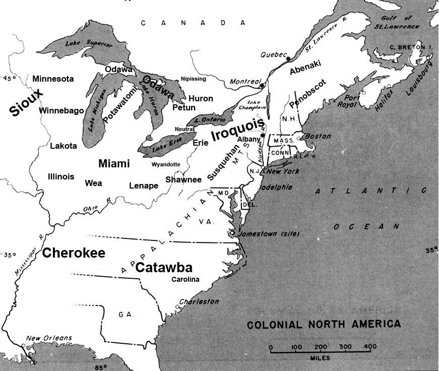
Duryea is a borough in the Greater Pittston area of Luzerne County, Pennsylvania, United States, south of Scranton. The Susquehanna River marks Duryea's western boundary, and the Lackawanna River flows through Duryea. It was incorporated as a borough in 1901, and had a notable switching rail yard, the Duryea yard (or Muller yard), connecting the central Wyoming Valley to destinations in lower New York and down-state Pennsylvania (in Harrisburg and Philadelphia). Coal mining and silk manufacturing were the chief industries in Duryea's early years. The population was 5,032 at the 2020 census. History Early history The area now known as Duryea Borough was historically the heartland of the Susquehannock tribe, also called the Conestoga, which were an Iroquoian people whose territory extended from lower New York State to the Potomac. The Susquehannock befriended the Dutch traders by 1612, who soon began trading tools and firearms for furs. The Dutch had established their trading posts ... [...More Info...] [...Related Items...] OR: [Wikipedia] [Google] [Baidu] |
List Of Sovereign States
The following is a list providing an overview of sovereign states around the world with information on their status and recognition of their sovereignty. The 206 listed states can be divided into three categories based on membership within the United Nations System: 193 UN member states, 2 UN General Assembly non-member observer states, and 11 other states. The ''sovereignty dispute'' column indicates states having undisputed sovereignty (188 states, of which there are 187 UN member states and 1 UN General Assembly non-member observer state), states having disputed sovereignty (16 states, of which there are 6 UN member states, 1 UN General Assembly non-member observer state, and 9 de facto states), and states having a special political status (2 states, both in free association with New Zealand). Compiling a list such as this can be a complicated and controversial process, as there is no definition that is binding on all the members of the community of nations concerni ... [...More Info...] [...Related Items...] OR: [Wikipedia] [Google] [Baidu] |
Susquehannock
The Susquehannock people, also called the Conestoga by some English settlers or Andastes were Iroquoian Native Americans who lived in areas adjacent to the Susquehanna River and its tributaries, ranging from its upper reaches in the southern part of what is now New York (near the lands of the Five Nations of the Iroquois Confederacy), through eastern and central Pennsylvania west of the Poconos and the upper Delaware River (near the lands of the Lenape), with lands extending beyond the mouth of the Susquehanna in Maryland along the west bank of the Potomac at the north end of the Chesapeake Bay. Evidence of their habitation has also been found in northern West Virginia and portions of southwestern Pennsylvania, which could be reached via the gaps of the Allegheny or several counties to the south, via the Cumberland Narrows pass which held the Nemacolin Trail. Both passes abutted their range and could be reached through connecting valleys from the West Branch Susquehanna ... [...More Info...] [...Related Items...] OR: [Wikipedia] [Google] [Baidu] |
American Civil War
The American Civil War (April 12, 1861 – May 26, 1865; also known by other names) was a civil war in the United States. It was fought between the Union ("the North") and the Confederacy ("the South"), the latter formed by states that had seceded. The central cause of the war was the dispute over whether slavery would be permitted to expand into the western territories, leading to more slave states, or be prevented from doing so, which was widely believed would place slavery on a course of ultimate extinction. Decades of political controversy over slavery were brought to a head by the victory in the 1860 U.S. presidential election of Abraham Lincoln, who opposed slavery's expansion into the west. An initial seven southern slave states responded to Lincoln's victory by seceding from the United States and, in 1861, forming the Confederacy. The Confederacy seized U.S. forts and other federal assets within their borders. Led by Confederate President Jefferson Davis, ... [...More Info...] [...Related Items...] OR: [Wikipedia] [Google] [Baidu] |
Borough (Pennsylvania)
In the U.S. Commonwealth of Pennsylvania, a borough (sometimes spelled boro) is a self-governing municipal entity, equivalent to a town in most jurisdictions, usually smaller than a city, but with a similar population density in its residential areas. Sometimes thought of as "junior cities", boroughs generally have fewer powers and responsibilities than full-fledged cities. Description All municipalities in Pennsylvania are classified as either cities, boroughs, or townships. The only exception is the town of Bloomsburg, recognized by the state government as the only incorporated town in Pennsylvania. Boroughs tend to have more developed business districts and concentrations of public and commercial office buildings, including court houses. Boroughs are larger, less spacious, and more developed than the relatively rural townships, which often have the greater territory and even surround boroughs of a related or even the same name. There are 956 boroughs and 56 cities in ... [...More Info...] [...Related Items...] OR: [Wikipedia] [Google] [Baidu] |
Old Forge, Lackawanna County, Pennsylvania
Old Forge is a borough in Lackawanna County, Pennsylvania, United States. The population was 8,524 at the 2020 census. It is located southwest of downtown Scranton and northeast of Wilkes-Barre. Geography Old Forge is located at (41.369679, −75.738297). The borough has a total area of , all of which is land. The major body of water flowing through the borough is the Lackawanna River, part of the Upper Susquehanna-Lackawanna Watershed. Acid mine drainage into the Lackawanna River from a borehole in Old Forge is the largest point source of pollution in the Chesapeake Bay watershed. History The history of Old Forge can be traced back to 1789 and Dr. William Smith, who was an army surgeon in the American Revolutionary War. During the 1820s, Charles Drake operated the only stagecoach inn between Wilkes-Barre and Carbondale. Drake's son, Ebenezer, secured a post office for Old Forge in 1848, where he served as postmaster until 1885. On May 26, 1871, ''Old Forge Township'' was d ... [...More Info...] [...Related Items...] OR: [Wikipedia] [Google] [Baidu] |
Confluence
In geography, a confluence (also: ''conflux'') occurs where two or more flowing bodies of water join to form a single channel. A confluence can occur in several configurations: at the point where a tributary joins a larger river (main stem); or where two streams meet to become the source of a river of a new name (such as the confluence of the Monongahela and Allegheny rivers at Pittsburgh, forming the Ohio); or where two separated channels of a river (forming a river island) rejoin at the downstream end. Scientific study of confluences Confluences are studied in a variety of sciences. Hydrology studies the characteristic flow patterns of confluences and how they give rise to patterns of erosion, bars, and scour pools. The water flows and their consequences are often studied with mathematical models. Confluences are relevant to the distribution of living organisms (i.e., ecology) as well; "the general pattern ownstream of confluencesof increasing stream flow and decreasing s ... [...More Info...] [...Related Items...] OR: [Wikipedia] [Google] [Baidu] |
Connecticut
Connecticut () is the southernmost state in the New England region of the Northeastern United States. It is bordered by Rhode Island to the east, Massachusetts to the north, New York to the west, and Long Island Sound to the south. Its capital is Hartford and its most populous city is Bridgeport. Historically the state is part of New England as well as the tri-state area with New York and New Jersey. The state is named for the Connecticut River which approximately bisects the state. The word "Connecticut" is derived from various anglicized spellings of "Quinnetuket”, a Mohegan-Pequot word for "long tidal river". Connecticut's first European settlers were Dutchmen who established a small, short-lived settlement called House of Hope in Hartford at the confluence of the Park and Connecticut Rivers. Half of Connecticut was initially claimed by the Dutch colony New Netherland, which included much of the land between the Connecticut and Delaware Rivers, although the firs ... [...More Info...] [...Related Items...] OR: [Wikipedia] [Google] [Baidu] |
Duryea Map , a borough in Luzerne County
{{Disambiguation ...
Duryea may refer to: *Duryea (surname) *Duryea Motor Wagon Company, first American automobile company *Duryea, Pennsylvania Duryea is a borough in the Greater Pittston area of Luzerne County, Pennsylvania, United States, south of Scranton. The Susquehanna River marks Duryea's western boundary, and the Lackawanna River flows through Duryea. It was incorporated as a boro ... [...More Info...] [...Related Items...] OR: [Wikipedia] [Google] [Baidu] |
Province Of Pennsylvania
The Province of Pennsylvania, also known as the Pennsylvania Colony, was a British North American colony founded by William Penn after receiving a land grant from Charles II of England in 1681. The name Pennsylvania ("Penn's Woods") refers to William's father, Admiral Sir William Penn. The Province of Pennsylvania was one of the two major Restoration colonies. The proprietary colony's charter remained in the hands of the Penn family until they were ousted by the American Revolution, when the Commonwealth of Pennsylvania was created and became one of the original thirteen states. " The lower counties on Delaware," a separate colony within the province, broke away during the American Revolution as " the Delaware State" and was also one of the original thirteen states. The colony attracted Quakers, Germans, and Scots-Irish frontiersmen. The Lenape promoted peace with the Quakers. However, wars eventually broke out after William Penn and Tamanend were no longer living. Lenape ... [...More Info...] [...Related Items...] OR: [Wikipedia] [Google] [Baidu] |
North America
North America is a continent in the Northern Hemisphere and almost entirely within the Western Hemisphere. It is bordered to the north by the Arctic Ocean, to the east by the Atlantic Ocean, to the southeast by South America and the Caribbean Sea, and to the west and south by the Pacific Ocean. Because it is on the North American Plate, North American Tectonic Plate, Greenland is included as a part of North America geographically. North America covers an area of about , about 16.5% of Earth's land area and about 4.8% of its total surface. North America is the third-largest continent by area, following Asia and Africa, and the list of continents and continental subregions by population, fourth by population after Asia, Africa, and Europe. In 2013, its population was estimated at nearly 579 million people in List of sovereign states and dependent territories in North America, 23 independent states, or about 7.5% of the world's population. In Americas (terminology)#Human ge ... [...More Info...] [...Related Items...] OR: [Wikipedia] [Google] [Baidu] |
Province Of Maryland
The Province of Maryland was an English and later British colony in North America that existed from 1632 until 1776, when it joined the other twelve of the Thirteen Colonies in rebellion against Great Britain and became the U.S. state of Maryland. Its first settlement and capital was St. Mary's City, in the southern end of St. Mary's County, which is a peninsula in the Chesapeake Bay and is also bordered by four tidal rivers. The province began as a proprietary colony of the English Lord Baltimore, who wished to create a haven for English Catholics in the New World at the time of the European wars of religion. Although Maryland was an early pioneer of religious toleration in the English colonies, religious strife among Anglicans, Puritans, Catholics, and Quakers was common in the early years, and Puritan rebels briefly seized control of the province. In 1689, the year following the Glorious Revolution, John Coode led a rebellion that removed Lord Baltimore, a Catholic, from pow ... [...More Info...] [...Related Items...] OR: [Wikipedia] [Google] [Baidu] |


.jpg)
