|
Dorah Pass
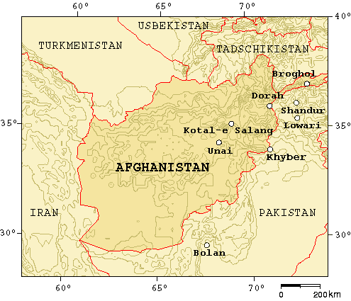
Dorah Pass, also called ''Durah Pass'', connects Badakshan Province of Afghanistan with Chitral District in Khyber Pakhtunkhwa, Pakistan. The Dorah Pass is more than high. It is located along the Durand Line border and crosses the Hindu Kush mountain range. Situated at the foot of the pass is Lake Dufferin, also known locally as Hawz-i Dorah. The lake is roughly long by over broad. Dorah Pass became important during the Soviet invasion of Afghanistan because the Soviets were unable to stop the flow of arms and men back and forth across the pass. Almost the entire Munji-speaking population of Afghanistan fled across the border to Chitral during the War in Afghanistan. Dorah Pass is situated in the Pamir, a high plateau sometimes called "The roof of the world" that joins Pakistan, Afghanistan, Tajikistan, and China. The Dorah Pass is one of the four major mountain passes that enter Chitral. The others are the Broghol Pass from the Wakhan District of Badakhshan, Afghanistan, Shan ... [...More Info...] [...Related Items...] OR: [Wikipedia] [Google] [Baidu] |
Durand Line
The Durand Line ( ps, د ډیورنډ کرښه; ur, ), forms the Pakistan–Afghanistan border, a international land border between Pakistan and Afghanistan in South Asia. The western end runs to the border with Iran and the eastern end to the border with China. The Durand Line was established in 1893 as the international border between India and the Emirate of Afghanistan by Mortimer Durand, a British diplomat of the Indian Civil Service, and Abdur Rahman Khan, the Afghan Emir, to fix the limit of their respective spheres of influence and improve diplomatic relations and trade. The British considered Afghanistan to be an independent state at the time, although they controlled its foreign affairs and diplomatic relations. The single-page Agreement, dated 12 November 1893, contains seven short articles, including a commitment not to exercise interference beyond the Durand Line. A joint British-Afghan demarcation survey took place starting from 1894, covering some of the bo ... [...More Info...] [...Related Items...] OR: [Wikipedia] [Google] [Baidu] |
Tajikistan
Tajikistan (, ; tg, Тоҷикистон, Tojikiston; russian: Таджикистан, Tadzhikistan), officially the Republic of Tajikistan ( tg, Ҷумҳурии Тоҷикистон, Jumhurii Tojikiston), is a landlocked country in Central Asia. It has an area of and an estimated population of 9,749,625 people. Its capital and largest city is Dushanbe. It is bordered by Afghanistan to the south, Uzbekistan to the west, Kyrgyzstan to the north, and China to the east. It is separated narrowly from Pakistan by Afghanistan's Wakhan Corridor. The traditional homelands of the Tajiks include present-day Tajikistan as well as parts of Afghanistan and Uzbekistan. The territory that now constitutes Tajikistan was previously home to several ancient cultures, including the city of Sarazm of the Neolithic and the Bronze Age and was later home to kingdoms ruled by people of different faiths and cultures, including the Oxus civilization, Andronovo culture, Buddhism, Nestorian Ch ... [...More Info...] [...Related Items...] OR: [Wikipedia] [Google] [Baidu] |
Mountain Passes Of Afghanistan
A mountain is an elevated portion of the Earth's crust, generally with steep sides that show significant exposed bedrock. Although definitions vary, a mountain may differ from a plateau in having a limited summit area, and is usually higher than a hill, typically rising at least 300 metres (1,000 feet) above the surrounding land. A few mountains are isolated summits, but most occur in mountain ranges. Mountains are formed through tectonic forces, erosion, or volcanism, which act on time scales of up to tens of millions of years. Once mountain building ceases, mountains are slowly leveled through the action of weathering, through slumping and other forms of mass wasting, as well as through erosion by rivers and glaciers. High elevations on mountains produce colder climates than at sea level at similar latitude. These colder climates strongly affect the ecosystems of mountains: different elevations have different plants and animals. Because of the less hospitable terrain and ... [...More Info...] [...Related Items...] OR: [Wikipedia] [Google] [Baidu] |
Institute For Comparative Research In Human Culture
The Institute for Comparative Research in Human Culture ( no, Instituttet for sammenlignende kulturforskning) is a humanities research institute based in Oslo, Norway. It was established in 1922 by Fredrik Stang. An independent institute, its task is to sponsor research mainly in the fields of comparative linguistics, folklore, religion, ethnology, archaeology and ethnography. It shares localities with the Norwegian Academy of Science and Letters. The board of directors consists of Per Kværne (chair), Arne Bugge Amundsen, Ivar Børklund, Tove Fjell, Ingar Kaldal, Svein Mønnesland and Aud Talle. At any given time, three of the board members are appointed by the Norwegian Academy of Science and Letters; the other four are appointed by the universities of Oslo, Bergen, Trondheim and Tromsø Tromsø (, , ; se, Romsa ; fkv, Tromssa; sv, Tromsö) is a municipality in Troms og Finnmark county, Norway. The administrative centre of the municipality is the city of Tromsø. Troms ... [...More Info...] [...Related Items...] OR: [Wikipedia] [Google] [Baidu] |
Upper Dir District
Upper Dir District ( ps, بر دير ولسوالۍ, ur, ) is a district in Malakand Division of Khyber Pakhtunkhwa province in Pakistan. The city of Dir is the district headquarters. Badogai Pass connects it to Utror. At the time of independence, Dir was a princely state ruled by Nawab Shah Jehan Khan. It was merged with Pakistan in 1969 and later on declared as a district in 1970. In 1996, the Dir District was divided into Upper and Lower Dir districts. This district is situated in the northern part of Pakistan. It borders Chitral district and Afghanistan on the north and northwest and Swat district to the east, and on the south by Lower Dir District.People of Dir are very hospitable. Dir is also called The Land of Hospitality and Brave People. History The British Raj honored Muhammad sharif Khan as Nawab of Dir in 1898 . By declaring his allegiance to the British Raj, Khan/Nawab, once exiled to Afghanistan by Umara Khan Mastkhel was seated as Nawab of Dir. He was succeed ... [...More Info...] [...Related Items...] OR: [Wikipedia] [Google] [Baidu] |
Lowari
Lowari Pass ( ur, درہ لواری), or Lowari Top, (el. 10,230 ft.) is a high mountain pass that connects Chitral with Dir in Khyber-Pakhtunkhwa, Pakistan. Lowari Top is a relatively low pass, by far the lowest pass to enter Chitral, the rest all being 12,000 to 15,000 feet. Lowari Top is closed by snow from late November to late May every year. During this time, jeeps cannot cross so men must travel by foot. This is dangerous, as there are high mountains on each side of Lowari Top, and a deadly avalanche can come at any moment without warning. Every winter a few people are killed by avalanches while crossing Lowari Top. Their bodies are buried under the snow and it is only when the summer comes and the snow melts that their bodies are found and their fate learned. Nevertheless, Lowari Top remains popular because it is the shortest route from Chitral to Peshawar. The other way would be down the Kunar River to Jalalabad through hostile Afghan Territory or the much longe ... [...More Info...] [...Related Items...] OR: [Wikipedia] [Google] [Baidu] |
Gilgit Valley
Gilgit Valley () is a valley located in Gilgit District in Gilgit-Baltistan, northern Pakistan. The Gilgit River flows through the valley. 375 km of road connects it to the town of Chitral via the Shandur Pass Shandur Pass( ur, ) is a pass located in Ghizer, District of Gilgit Baltistan . It is often called 'Roof of the World. During the annual ' Shandur Polo Festival,' there are polo matches played in Shandur Polo Ground on Shandur Top, between the ... (3,800 m). The town of Gilgit lies in the valley. File:Gilgit Valley, 2006.jpg, Gilgit Valley Image:Gilgit Valley 3.JPG, Gilgit Valley Image:Gilgit Valley from Sonikot 3.Jpg, Gilgit Valley from Sonikot Image:Gilgit Valley 2.Jpg, Broad View Of Gilgit Valley References Valleys of Gilgit-Baltistan {{G-B-geo-stub ur:گلگت ... [...More Info...] [...Related Items...] OR: [Wikipedia] [Google] [Baidu] |
Shandur
Shandur Pass( ur, ) is a pass located in Ghizer, District of Gilgit Baltistan . It is often called 'Roof of the World. During the annual 'Shandur Polo Festival,' there are polo matches played in Shandur Polo Ground on Shandur Top, between the teams of Chitral District and Gilgit-Baltistan Province. Approximately seven matches are played in the three days of the festival usually held on July 7th to 9th every year. The final match is played on July 9th between Teams A of Gilgit Baltistan and Chitral. Geography History In early thirties, UK's appointed Political Agent Major Evelyn Hey Cobb (later Lieutenant Colonel) passed an order to Niat Qabool Hayat Kakakhel, Nambardar of Ghizer to establish a huge polo ground in Shandur. Kakakhail soon implemented the orders of higher headquarters on the ground and with the help of his manpower he established a marvellous polo ground at Shandur. The polo ground was later on named "Mas Junali", as in Khowar language ‘mas’ is word for ... [...More Info...] [...Related Items...] OR: [Wikipedia] [Google] [Baidu] |
Wakhan District
Wakhan District is one of the 28 districts of Badakhshan Province in eastern Afghanistan. The district has a border with neighboring Tajikistan in the north, Xinjiang in China to the east, and Pakistan to the south (specifically Gilgit-Baltistan and Chitral District). See also * Afghanistan–China border * Wakhan * Wakhan Corridor External links * (Radio Television Afghanistan National Radio Television Afghanistan (RTA; ps, ''Da Afġanistan Mīlī Radīo Telvizoon'', fa, ''Rādīo Telvizoon-e Mīlī-e Afġānestān'', branded as ملی (meaning ''national'')) is the public-broadcasting organization of Afghanista ... (RTA Pashto)) * (RTA Dari) * * {{Authority control Districts of Badakhshan Province Wakhan ... [...More Info...] [...Related Items...] OR: [Wikipedia] [Google] [Baidu] |
Broghol
Broghil, also spelled Broghol, elevation , is a high mountain pass along the Durand Line border that crosses the Hindu Kush mountain range and connects Wakhan District of Badakhshan Province, Afghanistan with Chitral District of Khyber Pakhtunkhwa, Pakistan. History Broghil is a relatively low pass. It was closed for about three months each winter because of snow, but for much of the rest of the year it was passable even for cart traffic. It is one of the four major mountain passes entering Chitral District; the others are the Dorah Pass from Badakshan Province of Afghanistan, Shandur Top from Gilgit, and Lowari Top from Upper Dir District. The area of Broghil is inhabited by Wakhi and Kyrgyz people. European migration According to the National Geographic Genographic Project, Broghol Pass appears to be the route used by the ancestors of all modern Western Europeans to reach Europe. Modern Europeans carrying the M45 genetic marker crossed Broghol and then turned west; M45 f ... [...More Info...] [...Related Items...] OR: [Wikipedia] [Google] [Baidu] |
Pamir Mountains
The Pamir Mountains are a mountain range between Central Asia and Pakistan. It is located at a junction with other notable mountains, namely the Tian Shan, Karakoram, Kunlun, Hindu Kush and the Himalaya mountain ranges. They are among the world's highest mountains. Much of the Pamir Mountains lie in the Gorno-Badakhshan Province of Tajikistan. To the south, they border the Hindu Kush mountains along Afghanistan's Wakhan Corridor in Badakhshan Province, Chitral District, Chitral and Gilgit-Baltistan regions of Pakistan. To the north, they join the Tian Shan mountains along the Alay Valley of Kyrgyzstan. To the east, they extend to the range that includes China's Kongur Tagh, in the "Eastern Pamirs", separated by the Yarkand River, Yarkand valley from the Kunlun Mountains. Name and etymology Since Victorian times, they have been known as the "Roof of the World", presumably a translation from Persian language, Persian. Names In other languages they are called: ps, , ; k ... [...More Info...] [...Related Items...] OR: [Wikipedia] [Google] [Baidu] |


