Dorah Pass on:
[Wikipedia]
[Google]
[Amazon]
Dorah Pass, also called ''Durah Pass'', connects  Dorah Pass became important during the
Yidgha, A Language of Pakistan
{{Mountain passes of Pakistan Mountain passes of Afghanistan Chitral District Afghanistan–Pakistan border crossings Mountain passes of Khyber Pakhtunkhwa Landforms of Badakhshan Province
Badakshan Province
Badakhshan Province (Persian/ Uzbek: , ''Badaxšān'') is one of the 34 provinces of Afghanistan, located in the northeastern part of the country. It is bordered by Tajikistan's Gorno-Badakhshan in the north and the Pakistani regions of Lower ...
of Afghanistan
Afghanistan, officially the Islamic Emirate of Afghanistan,; prs, امارت اسلامی افغانستان is a landlocked country located at the crossroads of Central Asia and South Asia. Referred to as the Heart of Asia, it is bordere ...
with Chitral District
Chitral District ( ur, ) was the largest district in the Khyber-Pakhtunkhwa province of Pakistan, covering an area of 14,850 km², before splitting into Upper Chitral District and Lower Chitral District in 2018. Part of the Malakand Div ...
in Khyber Pakhtunkhwa
Khyber Pakhtunkhwa (; ps, خېبر پښتونخوا; Urdu, Hindko: خیبر پختونخوا) commonly abbreviated as KP or KPK, is one of the Administrative units of Pakistan, four provinces of Pakistan. Located in the Geography of Pakistan, ...
, Pakistan
Pakistan ( ur, ), officially the Islamic Republic of Pakistan ( ur, , label=none), is a country in South Asia. It is the world's List of countries and dependencies by population, fifth-most populous country, with a population of almost 24 ...
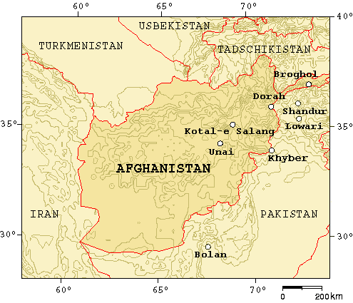
. The Dorah Pass is more than high. It is located along the Durand Line
The Durand Line ( ps, د ډیورنډ کرښه; ur, ), forms the Pakistan–Afghanistan border, a international land border between Pakistan and Afghanistan in South Asia. The western end runs to the border with Iran and the eastern end to th ...
border and crosses the Hindu Kush
The Hindu Kush is an mountain range in Central and South Asia to the west of the Himalayas. It stretches from central and western Afghanistan, Quote: "The Hindu Kush mountains run along the Afghan border with the North-West Frontier Provinc ...
mountain range. Situated at the foot of the pass is Lake Dufferin, also known locally as Hawz-i Dorah. The lake is roughly long by over broad.
 Dorah Pass became important during the
 Soviet invasion of Afghanistan
The Soviet Union,. officially the Union of Soviet Socialist Republics. (USSR),. was a transcontinental country that spanned much of Eurasia from 1922 to 1991. A flagship communist state, it was nominally a federal union of fifteen national ...
because the Soviets were unable to stop the flow of arms and men back and forth across the pass. Almost the entire Munji-speaking population of Afghanistan fled across the border to Chitral during the War in Afghanistan. Dorah Pass is situated in the Pamir Pamir may refer to:
Geographical features
* Pamir Mountains, a mountain range in Central Asia
** Pamir-Alay, a mountain system in Tajikistan, Kyrgyzstan and Uzbekistan, part of the Pamir Mountains
*A pamir (valley) is a high plateau or valley surro ...
, a high plateau sometimes called "The roof of the world" that joins Pakistan, Afghanistan, Tajikistan
Tajikistan (, ; tg, Тоҷикистон, Tojikiston; russian: Таджикистан, Tadzhikistan), officially the Republic of Tajikistan ( tg, Ҷумҳурии Тоҷикистон, Jumhurii Tojikiston), is a landlocked country in Centr ...
, and China.
The Dorah Pass is one of the four major mountain passes that enter Chitral. The others are the Broghol
Broghil, also spelled Broghol, elevation , is a high mountain pass along the Durand Line border that crosses the Hindu Kush mountain range and connects Wakhan District of Badakhshan Province, Afghanistan with Chitral District of Khyber Pakhtunkhw ...
Pass from the Wakhan District
Wakhan District is one of the 28 districts of Badakhshan Province in eastern Afghanistan. The district has a border with neighboring Tajikistan in the north, Xinjiang in China to the east, and Pakistan to the south (specifically Gilgit-Baltistan a ...
of Badakhshan, Afghanistan, Shandur Shandur Pass( ur, ) is a pass located in Ghizer, District of Gilgit Baltistan . It is often called 'Roof of the World.
During the annual ' Shandur Polo Festival,' there are polo matches played in Shandur Polo Ground on Shandur Top, between the ...
Top from Gilgit
Gilgit (; Shina: ; ur, ) is the capital city of Gilgit–Baltistan, Pakistan. The city is located in a broad valley near the confluence of the Gilgit River and the Hunza River. It is a major tourist destination in Pakistan, serving as a h ...
, and Lowari
Lowari Pass ( ur, درہ لواری), or Lowari Top, (el. 10,230 ft.) is a high mountain pass that connects Chitral with Dir in Khyber-Pakhtunkhwa, Pakistan. Lowari Top is a relatively low pass, by far the lowest pass to enter Chitral, ...
Top from Upper Dir District
Upper Dir District ( ps, بر دير ولسوالۍ, ur, ) is a district in Malakand Division of Khyber Pakhtunkhwa province in Pakistan. The city of Dir is the district headquarters. Badogai Pass connects it to Utror.
At the time of indepen ...
.
References
Books
* Morgenstierne, Georg (1926) Report on a Linguistic Mission to Afghanistan. Instituttet for Sammenlignende Kulturforskning, Serie C I-2. Oslo.External links
Yidgha, A Language of Pakistan
{{Mountain passes of Pakistan Mountain passes of Afghanistan Chitral District Afghanistan–Pakistan border crossings Mountain passes of Khyber Pakhtunkhwa Landforms of Badakhshan Province