|
Dongen Formation
The Dongen Formation ( nl, Formatie van Dongen; abbreviation: DO) is a geologic formation in the subsurface of the Netherlands. The formation consists of early Eocene marine clay and sand. It is named after the town of Dongen in North Brabant. Lithology and stratigraphy The Dongen Formation consists predominantly of marine clay, alternated with layers of fine sand or glauconiferous marl. The clay can also contain glauconite and locally thin layers of tuffite or loam can occur. The formation is subdivided into four members: *the Asse Member, clay with locally sandy layers, glauconite or/and nummulites; *the Brussels Member, fine glauconiferous sand, locally calcareous; *the Ieper Member, clay with layers of marl and limestone; *the Oosteind Member, clay with sand and tuffite layers. The base of the formation is often formed by a tuffite layer. The Dutch Dongen Formation correlates with the Belgian Ieper Group and Zenne Group. All of these units are marine sands and clay ... [...More Info...] [...Related Items...] OR: [Wikipedia] [Google] [Baidu] |
Formation (stratigraphy)
A geological formation, or simply formation, is a body of rock having a consistent set of physical characteristics (lithology) that distinguishes it from adjacent bodies of rock, and which occupies a particular position in the layers of rock exposed in a geographical region (the stratigraphic column). It is the fundamental unit of lithostratigraphy, the study of strata or rock layers. A formation must be large enough that it can be mapped at the surface or traced in the subsurface. Formations are otherwise not defined by the thickness (geology), thickness of their rock strata, which can vary widely. They are usually, but not universally, tabular in form. They may consist of a single lithology (rock type), or of alternating beds of two or more lithologies, or even a heterogeneous mixture of lithologies, so long as this distinguishes them from adjacent bodies of rock. The concept of a geologic formation goes back to the beginnings of modern scientific geology. The term was used by ... [...More Info...] [...Related Items...] OR: [Wikipedia] [Google] [Baidu] |
Zenne Group
The Zenne Group ( nl, Zenne Groep) is a group of rock strata in the subsurface of central and northwest Belgium. The group consists of three formations, all from the Ypresian and Lutetian ages (early Eocene, 50 to 40 million years old). These formation have their shallow marine facies in common. The three formations are: *the Aalter Formation, greenish sands and clays, found in East Flanders and West Flanders. *the Brussel Formation, marls and sands, found in Flemish and Walloon Brabant, Hainaut and Namur. *the Lede Formation, calcareous sands, found in almost all central Belgium. Stratigraphically on top of the Zenne Group are the late Eocene sands and clays of the Maldegem Formation The Maldegem Formation ( nl, Formatie van Maldegem; old name: Kallo Complex) is a geologic formation in the Belgian subsurface. The formation consists of alternating marine clay and sand strata, deposited during the late Eocene. The Maldegem For ..., which is not divided into a group. The Zenne ... [...More Info...] [...Related Items...] OR: [Wikipedia] [Google] [Baidu] |
Oligocene
The Oligocene ( ) is a geologic epoch of the Paleogene Period and extends from about 33.9 million to 23 million years before the present ( to ). As with other older geologic periods, the rock beds that define the epoch are well identified but the exact dates of the start and end of the epoch are slightly uncertain. The name Oligocene was coined in 1854 by the German paleontologist Heinrich Ernst Beyrich from his studies of marine beds in Belgium and Germany. The name comes from the Ancient Greek (''olígos'', "few") and (''kainós'', "new"), and refers to the sparsity of extant forms of molluscs. The Oligocene is preceded by the Eocene Epoch and is followed by the Miocene Epoch. The Oligocene is the third and final epoch of the Paleogene Period. The Oligocene is often considered an important time of transition, a link between the archaic world of the tropical Eocene and the more modern ecosystems of the Miocene. Major changes during the Oligocene included a global expansion o ... [...More Info...] [...Related Items...] OR: [Wikipedia] [Google] [Baidu] |
Unconformity
An unconformity is a buried erosional or non-depositional surface separating two rock masses or strata of different ages, indicating that sediment deposition was not continuous. In general, the older layer was exposed to erosion for an interval of time before deposition of the younger layer, but the term is used to describe any break in the sedimentary geologic record. The significance of angular unconformity (see below) was shown by James Hutton, who found examples of Hutton's Unconformity at Jedburgh in 1787 and at Siccar Point in 1788. The rocks above an unconformity are younger than the rocks beneath (unless the sequence has been overturned). An unconformity represents time during which no sediments were preserved in a region or were subsequently eroded before the next deposition. The local record for that time interval is missing and geologists must use other clues to discover that part of the geologic history of that area. The interval of geologic time not represented is ... [...More Info...] [...Related Items...] OR: [Wikipedia] [Google] [Baidu] |
Lower North Sea Group
The Lower North Sea Group (abbreviation: NL) is a group of geologic formations in the subsurface of the Netherlands and adjacent parts of the North Sea. The group is part of the North Sea Supergroup and consists of two marine formations of early Paleogene age, the older Landen Formation and younger Dongen Formation. It is in most places stratigraphically on top of the Late Cretaceous Chalk Group and overlain by the late Paleogene Middle North Sea Group The Middle North Sea Group (abbreviation: NM) is a group of geologic formations in the Dutch subsurface, part of the North Sea Supergroup. The three formations of this group form a thick sequence of sediments in the Dutch subsurface, they crop .... The Lower North Sea Group crops out in a few spots in the south of the Netherlands but is mostly overlain by younger deposits. It can be found in the subsurface of most of the Netherlands. References Geologic groups of Europe Lithostratigraphy of the Netherlands Geolo ... [...More Info...] [...Related Items...] OR: [Wikipedia] [Google] [Baidu] |
Landen Formation
The Landen Formation (abbreviation: LA) is a lithostratigraphic unit (a set of rock strata) in the subsurface of the Netherlands. This formation shares its name with the Belgian Landen Group, but the Belgian unit is thinner and has different definitions. The Landen Formation consists of shallow marine and lagoonal sediments (mostly clay, sandy clay and marl) from the late Paleocene to early Eocene (between 58 and 54 million years old). Dutch stratigraphers see the Landen Formation as part of the Lower North Sea Group. Lithology The Landen Formation can be maximally 150 meters in thickness. It is subdivided into five only regionally recognized members: *The Swalmen Member, lagoonal clay, sometimes with small lignite layers; *The Reusel Member, green sandy clay, loam and sand; *The Liessel Member, mica, pyrite and glauconite bearing clay, containing plant fossils; *The Orp Member, greenish grey sand; *The Gelinden Member, calcareous clay. Some of the sandy layers can have bee ... [...More Info...] [...Related Items...] OR: [Wikipedia] [Google] [Baidu] |
France
France (), officially the French Republic ( ), is a country primarily located in Western Europe. It also comprises of Overseas France, overseas regions and territories in the Americas and the Atlantic Ocean, Atlantic, Pacific Ocean, Pacific and Indian Oceans. Its Metropolitan France, metropolitan area extends from the Rhine to the Atlantic Ocean and from the Mediterranean Sea to the English Channel and the North Sea; overseas territories include French Guiana in South America, Saint Pierre and Miquelon in the North Atlantic, the French West Indies, and many islands in Oceania and the Indian Ocean. Due to its several coastal territories, France has the largest exclusive economic zone in the world. France borders Belgium, Luxembourg, Germany, Switzerland, Monaco, Italy, Andorra, and Spain in continental Europe, as well as the Kingdom of the Netherlands, Netherlands, Suriname, and Brazil in the Americas via its overseas territories in French Guiana and Saint Martin (island), ... [...More Info...] [...Related Items...] OR: [Wikipedia] [Google] [Baidu] |
Paris Basin
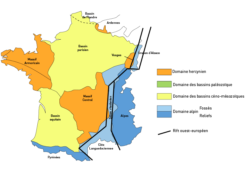
The Paris Basin is one of the major geological regions of France. It developed since the Triassic over remnant uplands of the Variscan orogeny (Hercynian orogeny). The sedimentary basin, no longer a single drainage basin, is a large sag in the craton, bordered by the Armorican Massif to the west, the Ardennes-Brabant axis to the north, the Massif des Vosges to the east, and the Massif Central to the south.Duval, B.C., 1992, Villeperdue Field, In Giant Oil and Gas Fields of the Decade, 1978-1988, AAPG Memoir 54, Halbouty, M.T., editor, Tulsa: American Association of Petroleum Geologists, Extent The region usually regarded as the Paris Basin is rather smaller than the area formed by the geological structure. The former occupies the centre of the northern half of the country, excluding Eastern France. The latter extends from the hills just south of Calais to Poitiers and from Caen to the brink of the middle Rhine Valley, east of Saarbrücken. Geography The landscape is one of ... [...More Info...] [...Related Items...] OR: [Wikipedia] [Google] [Baidu] |
North Sea
The North Sea lies between Great Britain, Norway, Denmark, Germany, the Netherlands and Belgium. An epeiric sea on the European continental shelf, it connects to the Atlantic Ocean through the English Channel in the south and the Norwegian Sea in the north. It is more than long and wide, covering . It hosts key north European shipping lanes and is a major fishery. The coast is a popular destination for recreation and tourism in bordering countries, and a rich source of energy resources, including wind and wave power. The North Sea has featured prominently in geopolitical and military affairs, particularly in Northern Europe, from the Middle Ages to the modern era. It was also important globally through the power northern Europeans projected worldwide during much of the Middle Ages and into the modern era. The North Sea was the centre of the Vikings' rise. The Hanseatic League, the Dutch Republic, and the British each sought to gain command of the North Sea and access t ... [...More Info...] [...Related Items...] OR: [Wikipedia] [Google] [Baidu] |
Paleocene–Eocene Thermal Maximum
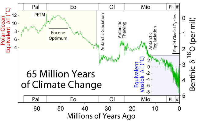
The Paleocene–Eocene thermal maximum (PETM), alternatively (ETM1), and formerly known as the "Initial Eocene" or "", was a time period with a more than 5–8 °C global average temperature rise across the event. This climate event occurred at the time boundary of the Paleocene and Eocene geological epochs. The exact age and duration of the event is uncertain but it is estimated to have occurred around 55.5 million years ago. The associated period of massive carbon release into the atmosphere has been estimated to have lasted from 20,000 to 50,000 years. The entire warm period lasted for about 200,000 years. Global temperatures increased by 5–8 °C. The onset of the Paleocene–Eocene thermal maximum has been linked to volcanism and uplift associated with the North Atlantic Igneous Province, causing extreme changes in Earth's carbon cycle and a significant temperature rise. The period is marked by a prominent negative excursion in carbon stable isotope () reco ... [...More Info...] [...Related Items...] OR: [Wikipedia] [Google] [Baidu] |
Sea Level
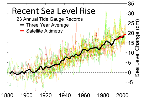
Mean sea level (MSL, often shortened to sea level) is an average surface level of one or more among Earth's coastal bodies of water from which heights such as elevation may be measured. The global MSL is a type of vertical datuma standardised geodetic datumthat is used, for example, as a chart datum in cartography and marine navigation, or, in aviation, as the standard sea level at which atmospheric pressure is measured to calibrate altitude and, consequently, aircraft flight levels. A common and relatively straightforward mean sea-level standard is instead the midpoint between a mean low and mean high tide at a particular location. Sea levels can be affected by many factors and are known to have varied greatly over geological time scales. Current sea level rise is mainly caused by human-induced climate change. When temperatures rise, Glacier, mountain glaciers and the Ice sheet, polar ice caps melt, increasing the amount of water in water bodies. Because most of human settlem ... [...More Info...] [...Related Items...] OR: [Wikipedia] [Google] [Baidu] |
Eustacy
Mean sea level (MSL, often shortened to sea level) is an average surface level of one or more among Earth's coastal bodies of water from which heights such as elevation may be measured. The global MSL is a type of vertical datuma standardised geodetic datumthat is used, for example, as a chart datum in cartography and marine navigation, or, in aviation, as the standard sea level at which atmospheric pressure is measured to calibrate altitude and, consequently, aircraft flight levels. A common and relatively straightforward mean sea-level standard is instead the midpoint between a mean low and mean high tide at a particular location. Sea levels can be affected by many factors and are known to have varied greatly over geological time scales. Current sea level rise is mainly caused by human-induced climate change. When temperatures rise, mountain glaciers and the polar ice caps melt, increasing the amount of water in water bodies. Because most of human settlement and infrastruc ... [...More Info...] [...Related Items...] OR: [Wikipedia] [Google] [Baidu] |


