|
Derryginny
Derryginny is a townland in the Parish of Tomregan, Barony of Tullyhaw, County Cavan, Ireland. Etymology The townland name is an anglicisation of the Gaelic placename "Doire Goinimhe" which means the 'Oakwood of the Sand', which possibly derives either from the sandbanks which form along the rivers running through it or from the large quarry on its northwest boundary. The 1609 Ulster Plantation Baronial map spells the name as ''Dirrigonie''. A 1610 grant spells it as ''Dirregenny''. The Irish State Papers for 1610 spell it as ''Diroginy''. A 1630 Inquisition spells it as ''Derrogeny''.The 1652 Commonwealth Survey spells it as ''Direganny''. The 1659 Down Survey map spells it as ''Derygenny''. The 1663 Hearth Money Rolls spell it as ''Dirigny''. A 1666 grant spells it ''Derrogenny alias Derrygenny''. William Petty's 1685 map spells it as ''Deregeny''. The 1790 Cavan Carvaghs list spells the name as ''Dirreginny''. Geography It is bounded on the north by Doon, Tomregan and G ... [...More Info...] [...Related Items...] OR: [Wikipedia] [Google] [Baidu] |
Carrowmore, County Cavan
Carrowmore, County Cavan is a townland in the Parish of Tomregan, Barony of Tullyhaw, County Cavan, Ireland. Etymology The townland name is an anglicisation of the Gaelic placename ''Ceathrú Mhór'' which means 'The Great Quarter'. It derives its name from the large size of the townland which in medieval times comprised a quarter of the ballybethagh of Calvagh, as it originally consisted of the present-day townlands of Carrowmore, Mullanacre Lower, Mullanacre Upper and Moher, a total of 2,066 statute acres. The oldest surviving mention of the name is on the 1609 Ulster Plantation Baronial map of Tullyhaw, where it is spelled ''Arrowmore''. A 1610 grant spells the name as ''Kearowmore''. A 1612 pardon spells it as ''Cearowmore''. A 1630 Inquisition spells it as ''Carraghmore''. The 1652 Commonwealth Survey spells the name as ''Karowmoreoghtragh''. The 1659 Down Survey map spells it as ''Carrowmore''. The 1663 Hearth Money Rolls spell it as ''Caramore'' and ''Upper Caramont'' ... [...More Info...] [...Related Items...] OR: [Wikipedia] [Google] [Baidu] |
Cullyleenan
Cullyleenan ( ga, Coill Uí Lionáin, ) is a townland in the Parish of Tomregan, Barony of Tullyhaw, County Cavan, Ireland. Etymology The townland name is an anglicisation of the Gaelic placename 'Coill Uí Lionáin' which means "O’Lenan’s Wood", which possibly belonged to a member of the Uí Lionán family who were a bardic family from County Fermanagh. Alternative meanings that have been suggested are 'Wood of the Fishing-bank' or ''Coill an Líonáin'' meaning 'The Wood of the Gorge'. The 1609 Ulster Plantation map spells the name as ''Colelenan''. A 1610 grant spells it ''Cowlynan''. A 1630 Inquisition spells it ''Cowlynan''. The 1652 Commonwealth Survey spells it as ''Coolelenan'' and the 1659 Down Survey map spells it as ''Colelolan''. A 1666 grant spells it ''Coolonenan alias Colelonan''. William Petty's 1685 map spells it as ''Cololan''. The 1790 Cavan Carvaghs list spells the name as ''Cullelinan''. Geography It is bounded on the north by Annagh townland, on the ... [...More Info...] [...Related Items...] OR: [Wikipedia] [Google] [Baidu] |
Snugborough
Snugborough is a townland in the Parish of Tomregan, Barony of Tullyhaw, County Cavan, Ireland. Etymology The townland originally formed two divisions, the older Irish names of which were ''Kealloge'' and ''Knockan''. ''Kealloge'' was an Anglicisation of the Gaelic placename 'Coill Óg', which means ''The New or Little Wood'' and it is depicted with this name on the 1609 Ulster Plantation Baronial map. ''Knockan'' was an Anglicisation of the Gaelic placename 'Cnocan', which means ''A little hill''. ''Keiloge'' formed part of the Manor of Calva which was granted to Walter Talbot in 1610 as part of the Plantation of Ulster. A 1630 Inquisition spells it as ''Killog''. The 1652 Commonwealth Survey spells the names as ''Keelogg'' and ''Knockan''. The 1659 Down Survey map spells it as ''Killoyne'' (Irish ''Coill Abhainn'', which means 'The Wood of the River'). The 1663 Hearth Money Rolls spell it as ''Knockane'' and ''Killogge''. A 1666 grant spells it as ''Killogey alias Killoyne ali ... [...More Info...] [...Related Items...] OR: [Wikipedia] [Google] [Baidu] |
Lecharrownahone
Lecharrownahone () is a townland in the civil parish of Templeport, County Cavan, Ireland. It lies in the Roman Catholic parish of Templeport and barony of Tullyhaw. Geography Lecharrownahone is bounded on the north by Carrowmore, County Cavan and Derryginny townlands in Tomregan parish and by Drumane townland, on the west by Killynaff and Crossmakelagher townlands, on the south by Cormeen townland in Kildallan parish and on the east by Agharaskilly townland in Tomregan parish. Its chief geographical features are the Shannon-Erne Waterway and the Crooked River (Ireland). Lecharrownahone is traversed by the regional R205 road, several rural lanes and the disused Cavan and Leitrim Railway. The townland covers 314 statute acres. History In medieval times the McGovern barony of Tullyhaw was divided into economic taxation areas called ballibetoes, from the Irish ''Baile Biataigh'' (Anglicized as 'Ballybetagh'), meaning 'A Provisioner's Town or Settlement'. The original purpos ... [...More Info...] [...Related Items...] OR: [Wikipedia] [Google] [Baidu] |
Crooked River (Ireland)
The Crooked River rises in Loughan Macmartin at the top of Slieve Rushen Mountain, in the townland of Carrowmore, Parish of Tomregan, Barony of Tullyhaw, County Cavan, Ireland. It then flows in a southerly direction and discharges into the Shannon–Erne Waterway in the townland of Derryginny Derryginny is a townland in the Parish of Tomregan, Barony of Tullyhaw, County Cavan, Ireland. Etymology The townland name is an anglicisation of the Gaelic placename "Doire Goinimhe" which means the 'Oakwood of the Sand', which possibly der .... It has a fish population of brown trout, pike, minnows, stoneloach and perch. References Rivers of County Cavan {{Cavan-geo-stub ... [...More Info...] [...Related Items...] OR: [Wikipedia] [Google] [Baidu] |
Doon, Tomregan
The townland of Doon () in the civil parish of Tomregan is in the electoral district of Ballyconnell. It is also situated in the barony of Tullyhaw. Geography Doon is bounded on the north by Mucklagh and Rakeelan townlands, on the east by Annagh townland, on the south by Derryginny townland and on the west by Gortoorlan townland. Its chief geographical features are the Shannon-Erne Waterway, mountain streams and some drumlin hills reaching an altitude of above sea-level. The major part of Ballyconnell town is situated in Doon and the townland is traversed by the N87 road (Ireland), the R205 road (Ireland), the L1063 road, Church Street, Main Street, Bridge Street, Preaching House Lane, Mucklagh Lane and the Border Road. The townland covers 125 statute acres, including of water. Etymology The 1609 Ulster Plantation Baronial map spells the name as ''Doone'' and a sub-division as ''Tennegh''. A 1610 grant spells it as ''Downe'' and ''Eannagh''. A 1630 Inquisition spells ... [...More Info...] [...Related Items...] OR: [Wikipedia] [Google] [Baidu] |
Gortoorlan
Gortoorlan is a townland in the Parish of Tomregan, Barony of Tullyhaw, County Cavan, Ireland. Etymology The townland name is an anglicisation of the Gaelic placename "Gort Urlainn" which means 'The Field of the Spear-Shaft'. An alternative meaning which has been suggested is 'Field of the Forecourt'. The oldest surviving mention of the name is in the Fiants of Queen Elizabeth I (4813) dated 19 January 1586 where it is spelled ''Gortoulleran''. The 1609 Ulster Plantation Baronial map spells the name as ''Gortooleran''. A 1610 grant spells it ''Gortolleran''. A 1630 Inquisition spells it ''Gortulleran''. The 1652 Commonwealth Survey spells it as ''Gortoorlane''. The 1659 Down Survey map spells it as ''Gortourlan''. The 1663 Hearth Money Rolls spell it as ''Gartorlan''. A 1666 grant spells it ''Gortourlan alias Gorteleran''. The 1790 Cavan Carvaghs list spells the name as ''Gorturlan''. Ambrose Leet's 1814 Directory spells the name as ''Gort-orlan''. Geography It is bounded on t ... [...More Info...] [...Related Items...] OR: [Wikipedia] [Google] [Baidu] |
Tomregan
Tomregan ( ga, Tuaim Dreagain, ) is a civil parish in the ancient barony of Tullyhaw. The parish straddles the international border between the Republic of Ireland and Northern Ireland. The largest population centre in the parish is Ballyconnell, County Cavan. The total area of the civil parish is 10,600 statute acres. Most of Tomregan's constituent townlands are situated in County Cavan while the remainder lie in County Fermanagh. In the Catholic Church, the ecclesiastical parish of Tomregan was split in the early 18th century, with the County Fermanagh townlands being assigned to the parish of Knockninny while the County Cavan townlands were united with the parish of Kildallan. The townlands The Fermanagh townlands in Tomregan civil parish are- Aghindisert, Carickaleese, Cloncoohy, Derrintony, Derryart, Garvary, Gortahurk, Gortaree, Gortineddan, Gortmullan, Knockadoois, Knockateggal, Tonymore and Ummera. The Cavan townlands in Tomregan civil parish are- Agharas ... [...More Info...] [...Related Items...] OR: [Wikipedia] [Google] [Baidu] |
Conall Cernach
Conall Cernach (modern spelling: Conall Cearnach) is a hero of the Ulaid in the Ulster Cycle of Irish mythology. He had a crooked neck and is said to have always slept with the head of a Connachtman under his knee. His epithet is normally translated as "victorious" or "triumphant", although it is an obscure word, and some texts struggle to explain it. Alternative meanings include "angular, having corners", "swollen", or "possessing a dish or receptacle". The original form of the name "Conall" in Ogham inscriptions was ''Cunavalas''. Legendary biography Physical description In the destruction of Da Derga's Hostel, Conall Cernach is described as follows: "I saw a man there in an ornamented dining compartment, who was the fairest of the warriors of Ireland. A fleecy crimson cloak about him. As white as the snow one of the cheeks on him, as freckled-red as the foxglove the other cheek. One of his two eyes is as blue as a hyacinth, as black as a beetle’s back the other eye. The me ... [...More Info...] [...Related Items...] OR: [Wikipedia] [Google] [Baidu] |
Masraige
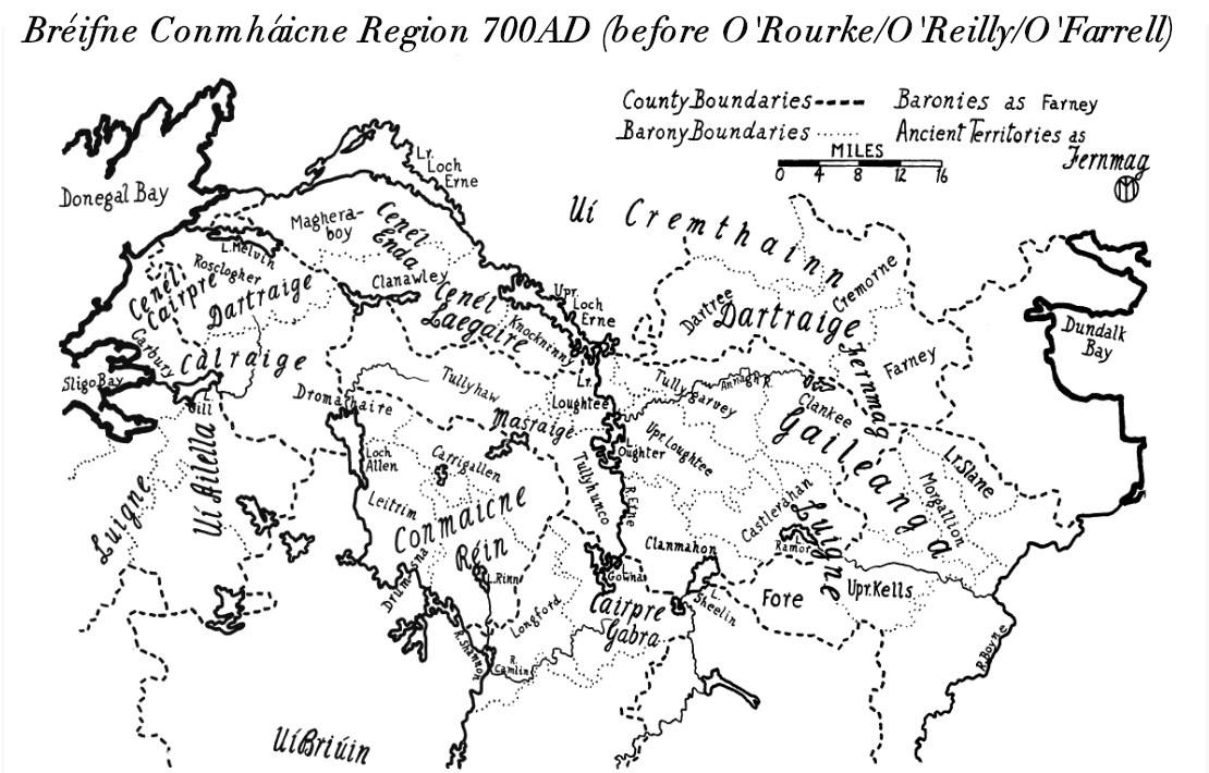
The Masraige () were a semi-legendary Fir Bolg tribe inhabiting Magh Slécht in County Cavan, Ireland. They were also called Masragii, Masraide, Masraidhe, Masruidhe, Mascraide, Masree, Macraighe or Mascraidhe. The name can be translated as "Beautiful/Fine-Looking/Handsome Folk", from Old Irish ''mass'' "fine, becoming, beautiful, handsome" and ''raige'' "pre-Gaelic tribe". Masraige is mentioned in the Life of Dallán Forgaill as his birthplace. In the Annals of the Four Masters, they are mentioned as having killed Conall Gulban -"''M464.3 Conall Gulban, son of Niall of the Nine Hostages (from whom are descended the Cinel Conaill), was slain by the old tribes of Magh Slecht, he having been found unprotected, and was buried at Fidhnach Maighe Rein, by Saint Caillín, as the Life of the aforesaid saint relates''." The Book of Fenagh mentions them as follows: Page 89 I prophesy thee, without anguish. Give me my tribute every time, as Conall Gulban gave it. Conall was the fi ... [...More Info...] [...Related Items...] OR: [Wikipedia] [Google] [Baidu] |
McGovern (name)
The surname McGovern ( ga, Mág Samhradháin), is of Irish origin and is found predominantly in the counties of Cavan (among the fifteen most common names), Fermanagh and Leitrim. The Irish name is Mag Samhradháin, meaning ''the Son of Samhradhán'', and the clan or sept takes its name from one Samhradhán who lived c. 1100 AD descended from 7th-century Eochaidh, a descendant of Brión mac Echach Muigmedóin. Eochaidh gave his name to Teallach Eochaid, modern day Tullyhaw in Cavan. This was long the territory of the McGoverns. Their strongholds were at Ballymagauran, Bawnboy, Coologe and Lissanover in Cavan. There are many variations found in the spelling of the name, all of which are attempts at a phonetic spelling of the Gaelic ''Mag Samhradháin''. The Mag part can be found as Mag, Meg, Mac, Mau, Mec, Mc, Ma or M'. The Samhradháin part (which may be attached to or detached from the ''Mag'' part and all its variations) can be found (the ''G'' being capitalised or not) ... [...More Info...] [...Related Items...] OR: [Wikipedia] [Google] [Baidu] |


