|
Chiningué
The riverside village of Logstown (1725?, 1727–1758) also known as Logg's Town, French: ''Chiningue'' (transliterated to ''Shenango'') near modern-day Baden, Pennsylvania, was a significant Native American settlement in Western Pennsylvania and the site of the 1752 signing of the Treaty of Logstown between the Ohio Company, the Colony of Virginia, and the Six Nations, which occupied the region. Being an unusually large settlement, and because of its strategic location in the Ohio Country, an area contested by France and England, Logstown was an important community for all parties living along the Ohio and tributary rivers. Logstown was a prominent trade and council site for the contending British and French colonial governments, both of which made abortive plans to construct forts near the town. [...More Info...] [...Related Items...] OR: [Wikipedia] [Google] [Baidu] |
Harmony Township, Beaver County, Pennsylvania
Harmony Township is a township and census-designated place in Beaver County, Pennsylvania, United States. The population was 3,197 at the 2010 census. It is part of the Pittsburgh metropolitan area. Geography Harmony Township is located in southeastern Beaver County at (40.607217, -80.220321). According to the United States Census Bureau, Harmony Township has a total area of , of which is land and , or 5.21%, is water. Surrounding and adjacent neighborhoods Harmony Township has four land borders, including Baden to the north, Economy to the east, Ambridge to the southwest, and the Allegheny County neighborhood of Leet Township to the south. Across the Ohio River to the west, Harmony Township runs adjacent with Aliquippa. Demographics As of the census of 2000, there were 3,373 people, 1,439 households, and 991 families residing in the township. The population density was 1,176.3 people per square mile (453.8/km). There were 1,509 housing units at an average density of ... [...More Info...] [...Related Items...] OR: [Wikipedia] [Google] [Baidu] |
Fort McIntosh (Pennsylvania)
Fort McIntosh was an early American log frontier fort situated near the confluence of the Ohio River and the Beaver River in what is now Beaver, Pennsylvania. The fortress was constructed in 1778 under the direction of Lt. Col. Cambray-Digny, a French engineer, and named in honor of General Lachlan McIntosh. The fortress was the site of the signing of the Treaty of Fort McIntosh on January 21, 1785. It was occupied until it was abandoned in 1791. After the Revolution, the fort was the home of the First American Regiment, the oldest active unit in the United States Army. The fort was in the form of a trapezoid, about 150 feet on each side, with raised earthen bastions on each corner. Log palisades connected the bastions, and a 15 foot wide ditch protected three sides of the fort, with the 130 foot slope to the Ohio River protecting the other side. Inside were three barracks, warehouses, officer's quarters, a forge, kitchen, and powder magazines. The fort may have had either two ... [...More Info...] [...Related Items...] OR: [Wikipedia] [Google] [Baidu] |
Opessa Straight Tail
Opessa Straight Tail (), also known as Wopatha or Wapatha, was a Pekowi Shawnee Chief. He was the son of Straight Tail Meaurroway Opessa. He is best known for signing, on 23 April 1701, the "Articles of friendship and agreement between William Penn and the Susquehannah, Shawonah, and North Patomack Indians," that designated lands and conditions of coexistence between those tribes and the English settlers. Birth and early life His exact place of birth is unknown, but was most likely either Indiana or Illinois. He was living with his father in Illinois in 1674 when his village was visited by Louis Jolliet and René-Robert Cavelier, Sieur de La Salle, accompanied by Martin Chartier. In 1674 Chartier married Opessa's sister Sewatha Straight Tail (1660–1759). Chartier led a mutiny against La Salle in 1680 and became an outlaw, fleeing first to upstate New York, but later returning to live with Opessa's family at Starved Rock (later known as Fort St. Louis). Chartier returned to ... [...More Info...] [...Related Items...] OR: [Wikipedia] [Google] [Baidu] |
Wyoming Valley, Pennsylvania
The Wyoming Valley is a historic industrialized region of Northeastern Pennsylvania. The region is historically notable for its influence in helping fuel the American Industrial Revolution with its many anthracite coal-mines. As a metropolitan area, it is known as the Scranton/Wilkes-Barre metropolitan area, after its principal cities, Scranton and Wilkes-Barre. With a population of 567,559 as of the 2020 United States census, it is the fifth-largest metropolitan area in Pennsylvania, after the Delaware Valley, Greater Pittsburgh, the Lehigh Valley, and the Harrisburg–Carlisle metropolitan statistical areas. Within the geology of Pennsylvania the Wyoming Valley makes up its own unique physiographic province, the Anthracite Valley. Greater Pittston occupies the center of the valley. Scranton is the most populated city in the metropolitan area with a population of 77,114. The city of Scranton grew in population after the 2015 mid-term census while Wilkes-Barre declined in po ... [...More Info...] [...Related Items...] OR: [Wikipedia] [Google] [Baidu] |
Kakowatcheky
Kakowatcheky (c. 1670 - c. 1755 or 1758), also known as Kakowatchiky, Cachawatsiky, Kakowatchy, or Kakowatchey, was a Pekowi Shawnee chief believed to be among the first to bring Shawnee people into Pennsylvania. For about fifty years he and the Shawnees lived together with European colonists in Pennsylvania until the mid-1740s when many Shawnees and other Native Americans migrated to the Ohio River Valley. In 1743, Kakowatcheky moved to Logstown, on the Ohio River, where he may have continued to live until 1755 or later, that being the last year in which his name appears in the Pennsylvania records. Colonel James Patton of Virginia visited Logstown in June 1752 and refers to him in his journal as being then bedridden. His chieftainship extended for more than sixty years. Arrival in Pennsylvania Nothing is known of his early life, including his exact date of birth. He may have been born in Ohio. John Heckewelder in his brief history of the "Shawanos" refers to "Chief Gachga ... [...More Info...] [...Related Items...] OR: [Wikipedia] [Google] [Baidu] |
Senecas
The Seneca () ( see, Onödowáʼga:, "Great Hill People") are a group of Indigenous Iroquoian-speaking people who historically lived south of Lake Ontario, one of the five Great Lakes in North America. Their nation was the farthest to the west within the Six Nations or Iroquois League (Haudenosaunee) in New York before the American Revolution. In the 21st century, more than 10,000 Seneca live in the United States, which has three federally recognized Seneca tribes. Two of them are centered in New York: the Seneca Nation of Indians, with two reservations in western New York near Buffalo; and the Tonawanda Seneca Nation. The Seneca-Cayuga Nation is in Oklahoma, where their ancestors were relocated from Ohio during the Indian Removal. Approximately 1,000 Seneca live in Canada, near Brantford, Ontario, at the Six Nations of the Grand River First Nation. They are descendants of Seneca who resettled there after the American Revolution, as they had been allies of the British and for ... [...More Info...] [...Related Items...] OR: [Wikipedia] [Google] [Baidu] |
Cayugas
The Cayuga ( Cayuga: Gayogo̱hó꞉nǫʼ, "People of the Great Swamp") are one of the five original constituents of the Haudenosaunee (Iroquois), a confederacy of Native Americans in New York. The Cayuga homeland lies in the Finger Lakes region along Cayuga Lake, between their league neighbors, the Onondaga to the east and the Seneca to the west. Today Cayuga people belong to the Six Nations of the Grand River First Nation in Ontario, and the federally recognized Cayuga Nation of New York and the Seneca-Cayuga Tribe of Oklahoma. History Political relations between the Cayuga, the British, and the Thirteen Colonies during the American Revolution were complicated and variable, with Cayuga warriors fighting on both sides (as well as abstaining from war entirely). Most of the Iroquois nations allied with the British, in part hoping to end encroachment on their lands by colonists. In 1778, various Iroquois bands, oft allied with British-colonial loyalists (Tories) conducted a s ... [...More Info...] [...Related Items...] OR: [Wikipedia] [Google] [Baidu] |
Lenape
The Lenape (, , or Lenape , del, Lënapeyok) also called the Leni Lenape, Lenni Lenape and Delaware people, are an indigenous peoples of the Northeastern Woodlands, who live in the United States and Canada. Their historical territory included present-day northeastern Delaware, New Jersey and eastern Pennsylvania along the Delaware River watershed, New York City, western Long Island, and the lower Hudson Valley. Today, Lenape people belong to the Delaware Nation and Delaware Tribe of Indians in Oklahoma; the Stockbridge–Munsee Community in Wisconsin; and the Munsee-Delaware Nation, Moravian of the Thames First Nation, and Delaware of Six Nations in Ontario. The Lenape have a matrilineal clan system and historically were matrilocal. During the last decades of the 18th century, most Lenape were removed from their homeland by expanding European colonies. The divisions and troubles of the American Revolutionary War and United States' independence pushed them farther west. ... [...More Info...] [...Related Items...] OR: [Wikipedia] [Google] [Baidu] |
Ambridge, Pennsylvania
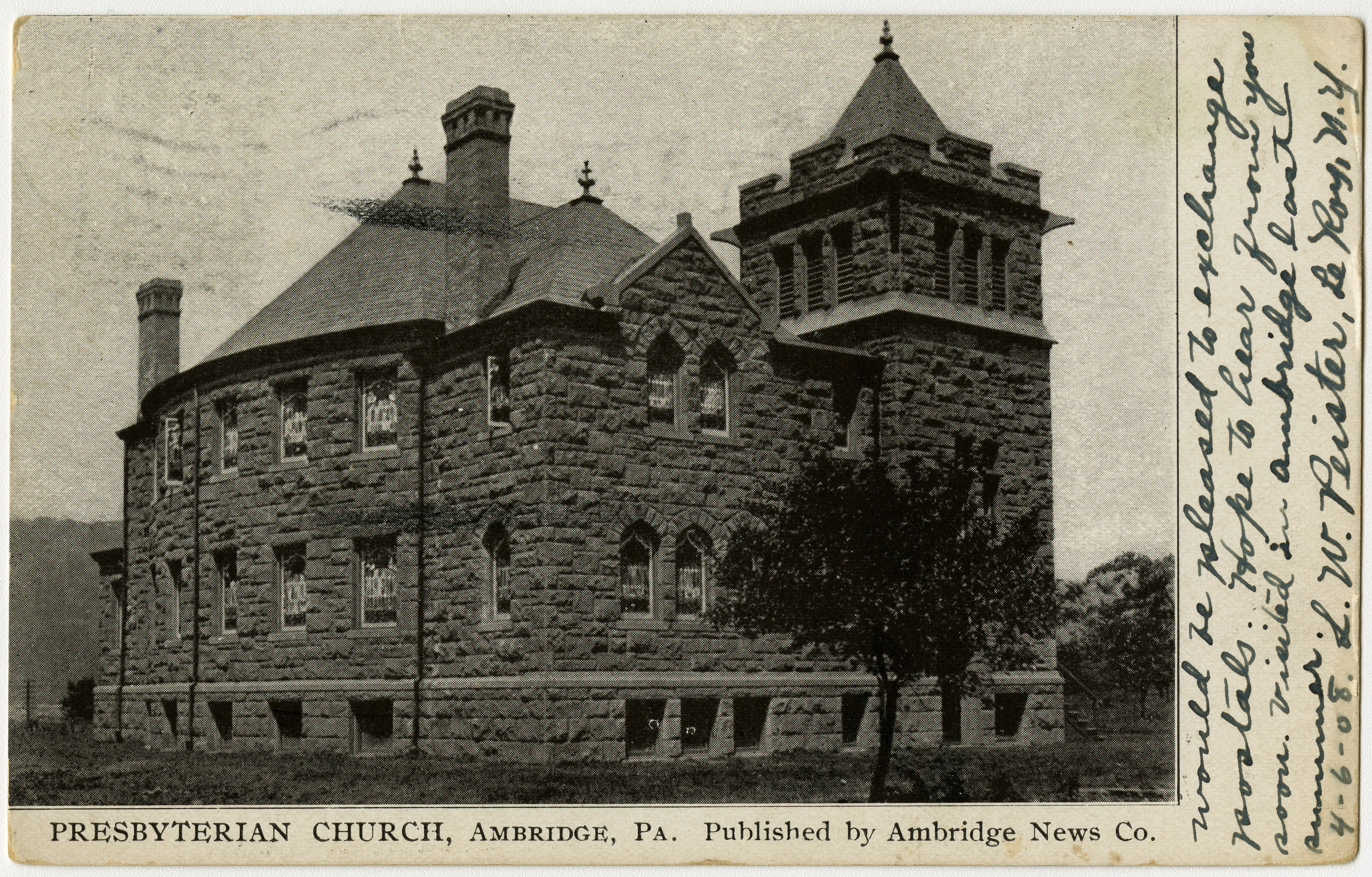
Ambridge is a borough in Beaver County, Pennsylvania, United States. Incorporated in 1905 as a company town by the American Bridge Company, Ambridge is located 16 miles (25 km) northwest of Pittsburgh, along the Ohio River. The population was 6,960 at the 2020 census. History Early history The town is near the location of Legionville, the training camp for General "Mad" Anthony Wayne's Legion of the United States. Wayne's was the first attempt to provide basic training for regular U.S. Army recruits and Legionville was the first facility established expressly for this purpose. The Harmony Society first settled the area in the early 19th century, founding the village of "Ökonomie" or Economy in 1824. Although initially successful, accumulating significant landholdings, the sect went into decline. By the end of the 19th century, only a few Harmonists remained. The Society was dissolved and its vast real estate holdings sold, much of it to the American Bridge Company, who s ... [...More Info...] [...Related Items...] OR: [Wikipedia] [Google] [Baidu] |
Shawnee
The Shawnee are an Algonquian-speaking indigenous people of the Northeastern Woodlands. In the 17th century they lived in Pennsylvania, and in the 18th century they were in Pennsylvania, Ohio, Indiana and Illinois, with some bands in Kentucky and Alabama. By the 19th century, they were forcibly removed to Missouri, Kansas, Texas, and ultimately Indian Territory, which became Oklahoma under the 1830 Indian Removal Act. Today, Shawnee people are enrolled in three federally recognized tribes, all headquartered in Oklahoma: the Absentee-Shawnee Tribe of Indians, Eastern Shawnee Tribe of Oklahoma, and Shawnee Tribe. Etymology Shawnee has also been written as Shaawanwaki, Ša·wano·ki, Shaawanowi lenaweeki, and Shawano. Algonquian languages have words similar to the archaic ''shawano'' (now: ''shaawanwa'') meaning "south". However, the stem ''šawa-'' does not mean "south" in Shawnee, but "moderate, warm (of weather)": See Charles F. Voegelin, "šawa (plus -ni, -te) MODERATE, WARM ... [...More Info...] [...Related Items...] OR: [Wikipedia] [Google] [Baidu] |
Cirsium Vulgare
''Cirsium vulgare'', the spear thistle, bull thistle, or common thistle, is a species of the Asteraceae genus ''Cirsium'', native throughout most of Europe (north to 66°N, locally 68°N), Western Asia (east to the Yenisei Valley), and northwestern Africa ( Atlas Mountains).''Flora Europaea''''Cirsium vulgare''/ref> It is also naturalised in North America, Africa, and Australia and is an invasive weed in some areas. It is the national flower of Scotland. The plant provides a great deal of nectar for pollinators. It was rated in the top 10 for most nectar production (nectar per unit cover per year) in a UK plants survey conducted by the AgriLand project which is supported by the UK Insect Pollinators Initiative. Marsh thistle, ''Cirsium palustre'', was ranked in first place while this thistle was ranked in sixth place. It also was a top producer of nectar sugar in another study in Britain, ranked third with a production per floral unit of (2300 ± 400 μg). Description It i ... [...More Info...] [...Related Items...] OR: [Wikipedia] [Google] [Baidu] |
Joseph Pierre De Bonnecamps
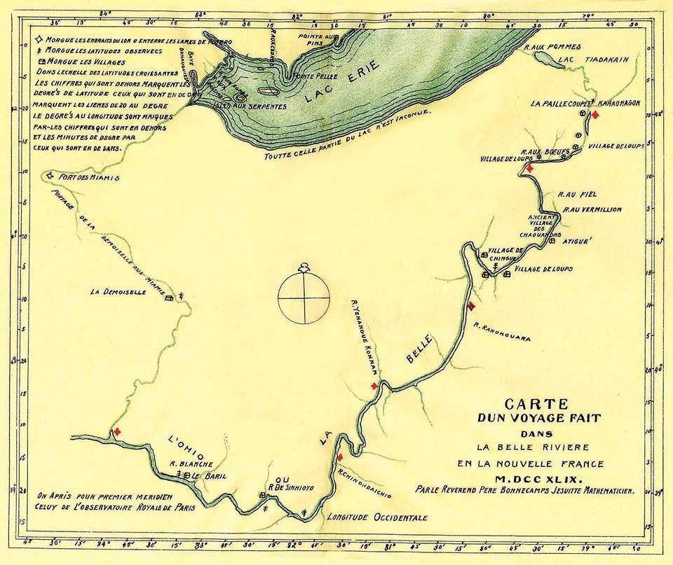
Joseph Pierre de Bonnecamps (7September 170828May 1790) was a French Jesuit, missionary, priest and professor and tutor. Biography Bonnecamps was born in Vannes, France. He entered the Jesuit seminary at Paris in 1727 and was ordained in 1743. He was professor of hydrography at the Collège de Québec, New France, from 1743 to 1757, during which time he was a member of the expedition of Pierre Joseph Céloron de Blainville to the Ohio Valley from June to November 1749, occupying the roles of chaplain, hydrographer and historian. He completed the first map of the Ohio Valley. He travelled for health reasons to France in 1757—1758; the next year, he returned to New France as professor or mathematics at the Collège de Québec, then at the Collège du Mont (affiliated with the University of Caen Normandy, the building of which today houses the Normandy Antiquities Museum) in Caen from 1759 to 1760. Defrocked during the suppression of the Jesuits in France in 1762, he bec ... [...More Info...] [...Related Items...] OR: [Wikipedia] [Google] [Baidu] |


