|
Chilean Antarctica
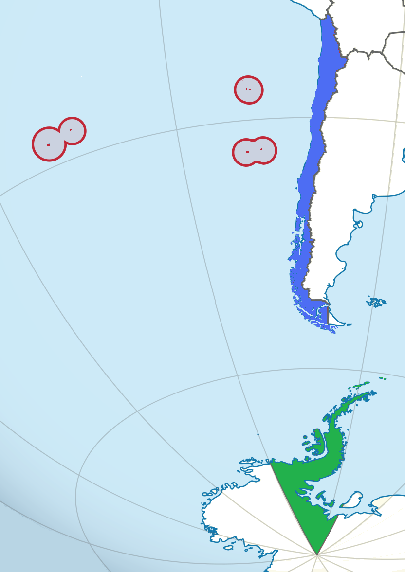
The Chilean Antarctic Territory or Chilean Antarctica (Spanish: ''Territorio Chileno Antártico'', ''Antártica Chilena'') is the territory in Antarctica claimed by Chile. The Chilean Antarctic Territory ranges from 53° West to 90° West and from the South Pole to the 60° South parallel, partially overlapping the Argentine and British Antarctic claims. It is administered by the Cabo de Hornos municipality in the South American mainland. The territory claimed by Chile covers the South Shetland Islands, Antarctic Peninsula, called ''"O'Higgins Land"'' ''("Tierra de O'Higgins" in Spanish)'' in Chile, and adjacent islands, the Alexander Island, Charcot Island, and part of the Ellsworth Land, among others. It has an area of 1,250,257.6 km2. Its boundaries are defined by Decree 1747, issued on November 6, 1940, and published on June 21, 1955, the Ministry of Foreign Affairs established: Within Chilean territorial organization Antártica is the name of the commune that ... [...More Info...] [...Related Items...] OR: [Wikipedia] [Google] [Baidu] |
List Of Sovereign States
The following is a list providing an overview of sovereign states around the world with information on their status and recognition of their sovereignty. The 206 listed states can be divided into three categories based on membership within the United Nations System: 193 UN member states, 2 UN General Assembly non-member observer states, and 11 other states. The ''sovereignty dispute'' column indicates states having undisputed sovereignty (188 states, of which there are 187 UN member states and 1 UN General Assembly non-member observer state), states having disputed sovereignty (16 states, of which there are 6 UN member states, 1 UN General Assembly non-member observer state, and 9 de facto states), and states having a special political status (2 states, both in free association with New Zealand). Compiling a list such as this can be a complicated and controversial process, as there is no definition that is binding on all the members of the community of nations concerni ... [...More Info...] [...Related Items...] OR: [Wikipedia] [Google] [Baidu] |
Chile
Chile, officially the Republic of Chile, is a country in the western part of South America. It is the southernmost country in the world, and the closest to Antarctica, occupying a long and narrow strip of land between the Andes to the east and the Pacific Ocean to the west. Chile covers an area of , with a population of 17.5 million as of 2017. It shares land borders with Peru to the north, Bolivia to the north-east, Argentina to the east, and the Drake Passage in the far south. Chile also controls the Pacific islands of Juan Fernández, Isla Salas y Gómez, Desventuradas, and Easter Island in Oceania. It also claims about of Antarctica under the Chilean Antarctic Territory. The country's capital and largest city is Santiago, and its national language is Spanish. Spain conquered and colonized the region in the mid-16th century, replacing Inca rule, but failing to conquer the independent Mapuche who inhabited what is now south-central Chile. In 1818, after declaring in ... [...More Info...] [...Related Items...] OR: [Wikipedia] [Google] [Baidu] |
Ellsworth Land
Ellsworth Land is a portion of the Antarctic continent bounded on the west by Marie Byrd Land, on the north by Bellingshausen Sea, on the northeast by the base of Antarctic Peninsula, and on the east by the western margin of the Filchner–Ronne Ice Shelf. It extends between 103°24'W and 79°45'W. The area west of 90°W is unclaimed, the area between 84°W and 90°W is claimed by Chile only, and the remainder by Chile and the United Kingdom as a part of the British Antarctic Territory. Eights Coast stretches between 103°24'W and 89°35'W, and Bryan Coast between 89°35'W and 79°45'W. It is largely a high ice plateau, but includes the Ellsworth Mountains and a number of scattered mountain groups: Hudson, Jones, Behrendt, Hauberg, Merrick, Sweeney and Scaife Mountains. This land lies near the center of the area traversed by American explorer Lincoln Ellsworth on an airplane flight during November–December 1935. It was named for him by the Advisory Committee on Antarct ... [...More Info...] [...Related Items...] OR: [Wikipedia] [Google] [Baidu] |
Charcot Island
Charcot Island or Charcot Land is an island administered under the Antarctic Treaty System, long and wide, which is ice covered except for prominent mountains overlooking the north coast. Charcot Island lies within the Bellingshausen Sea, west of Alexander Island, and about north of Latady Island. A notable landmark of the island is its northernmost point, Cape Byrd. History Charcot Island was discovered on 11 January 1910 by the French Antarctic Expedition under Jean-Baptiste Charcot, who, at the insistence of his crew and the recommendation of Edwin S. Balch and others, named it Charcot Land. He did so with the stated intention of honoring his father, Jean-Martin Charcot, a famous French physiciaThe insularity of Charcot Land was proved by Sir Hubert Wilkins, who flew around it on 29 December 1929. 2009 Collapse of ice bridge The ice bridge holding the Wilkins Ice Shelf to the Antarctic coastline and Charcot Island was long but only wide at its narrowest point – in 1 ... [...More Info...] [...Related Items...] OR: [Wikipedia] [Google] [Baidu] |
Alexander Island
Alexander Island, which is also known as Alexander I Island, Alexander I Land, Alexander Land, Alexander I Archipelago, and Zemlja Alexandra I, is the largest island of Antarctica. It lies in the Bellingshausen Sea west of Palmer Land, Antarctic Peninsula from which it is separated by Marguerite Bay and George VI Sound. The George VI Ice Shelf entirely fills George VI Sound and connects Alexander Island to Palmer Land. The island partly surrounds Wilkins Sound, which lies to its west.Stewart, J. (2011) ''Antarctic An Encyclopedia'' McFarland & Company Inc, New York. 1776 pp. . Alexander Island is about long in a north–south direction, wide in the north, and wide in the south. Alexander Island is the second-largest uninhabited island in the world, after Devon Island. History Alexander Island was discovered on January 28, 1821, by a Russian expedition under Fabian Gottlieb von Bellingshausen, who named it Alexander I Land for the reigning Tsar Alexander I of Russia. Wha ... [...More Info...] [...Related Items...] OR: [Wikipedia] [Google] [Baidu] |
Antarctic Peninsula
The Antarctic Peninsula, known as O'Higgins Land in Chile and Tierra de San Martín in Argentina, and originally as Graham Land in the United Kingdom and the Palmer Peninsula in the United States, is the northernmost part of mainland Antarctica. The Antarctic Peninsula is part of the larger peninsula of West Antarctica, protruding from a line between Cape Adams (Weddell Sea) and a point on the mainland south of the Eklund Islands. Beneath the ice sheet that covers it, the Antarctic Peninsula consists of a string of bedrock islands; these are separated by deep channels whose bottoms lie at depths considerably below current sea level. They are joined by a grounded ice sheet. Tierra del Fuego, the southernmost tip of South America, is about away across the Drake Passage. The Antarctic Peninsula is in area and 80% ice-covered. The marine ecosystem around the western continental shelf of the Antarctic Peninsula (WAP) has been subjected to rapid climate change. Over the past 50 ... [...More Info...] [...Related Items...] OR: [Wikipedia] [Google] [Baidu] |
South Shetland Islands
The South Shetland Islands are a group of Antarctic islands with a total area of . They lie about north of the Antarctic Peninsula, and between southwest of the nearest point of the South Orkney Islands. By the Antarctic Treaty of 1959, the islands' sovereignty is neither recognized nor disputed by the signatories and they are free for use by any signatory for non-military purposes. The islands have been claimed by the United Kingdom since 1908 and as part of the British Antarctic Territory since 1962. They are also claimed by the governments of Chile (since 1940, as part of the Antártica Chilena province) and Argentina (since 1943, as part of Argentine Antarctica, Tierra del Fuego Province). Several countries maintain research stations on the islands. Most of them are situated on King George Island, benefitting from the airfield of the Chilean base Eduardo Frei. There are sixteen research stations in different parts of the islands, with Chilean stations being ... [...More Info...] [...Related Items...] OR: [Wikipedia] [Google] [Baidu] |
Continental Chile
Continental Chile is the name given to the Chilean territory located on the continental shelf of South America. This term serves to distinguish the South American area from the insular territories, known as Insular Chile, as from the Antarctic Chile (Chilean Antarctic Territory). The existence of this three areas of effective or claimed Chilean sovereignty is what supports the existing tricontinental principle in this country. In addition, this term specifies the time zones of mainland Chile and the Juan Fernández Islands and the Desventuradas Islands, located in the UTC−4 time zone, as "continental Chile" however, the Magallanes and Chilean Antarctica Region are in the UTC–3 time zone. Easter Island and the Isla Salas y Gómez, both in Polynesia, are in the UTC−6 time zone. Continental Chile has a surface of 756,770 km2, representing 99.976% of the total surface of the country under effective administration. However, considering the claim in Antarctic, this perce ... [...More Info...] [...Related Items...] OR: [Wikipedia] [Google] [Baidu] |
Cabo De Hornos, Chile
Cabo de Hornos (''Cape Horn'') is a Chilean commune located in the south of Tierra del Fuego archipelago, in Antártica Province, Magallanes Region. The municipality of Cabo de Hornos, located in the town of Puerto Williams, also administers the Antártica commune. It is named for Cabo de Hornos, or "Cape Horn", the southern tip of South America. Demographics According to the 2002 census of the National Statistics Institute, Cabo de Hornos spans an area of and has 2,262 inhabitants (1,403 men and 859 women). Of these, 1,952 (86.3%) lived in urban areas and 310 (13.7%) in rural areas. The population grew by 24.7% (448 persons) between the 1992 and 2002 censuses. Administration As a commune, Cabo de Hornos is a third-level administrative division of Chile administered by a municipal council, headed by an alcalde who is directly elected every four years. The 2016-2020 alcalde is Patricio Fernández ( PDC). The communal council has the following members: Daniel Fernando Valdeben ... [...More Info...] [...Related Items...] OR: [Wikipedia] [Google] [Baidu] |
British Antarctic Territory
The British Antarctic Territory (BAT) is a sector of Antarctica claimed by the United Kingdom as one of its 14 British Overseas Territories, of which it is by far the largest by area. It comprises the region south of 60°S latitude and between longitudes and , forming a wedge shape that extends to the South Pole, overlapped by the Antarctic claims of Argentina (Argentine Antarctica) and Chile (Chilean Antarctic Territory). The Territory was formed on 3 March 1962, although the UK's claim to this portion of the Antarctic dates back to letters patent of 1908 and 1917. The area now covered by the Territory includes three regions which, before 1962, were administered by the British as separate dependencies of the Falkland Islands: Graham Land, the South Orkney Islands, and the South Shetland Islands. The United Kingdom's claim to the region has been suspended since the Antarctic Treaty came into force in 1961, Article 4 of which states "No acts or activities taking place ... [...More Info...] [...Related Items...] OR: [Wikipedia] [Google] [Baidu] |
Argentine Antarctica
Argentine Antarctica ( es, Antártida Argentina or Sector Antártico Argentino) is an area of Antarctica claimed by Argentina as part of its national territory. It consists of the Antarctic Peninsula and a triangular section extending to the South Pole, delimited by the 25th meridian west, 25° West and 74th meridian west, 74° West meridians and the 60th parallel south, 60° South parallel. This region overlaps the British Antarctic Territory, British and Chilean Antarctic Territory, Chilean claims in Antarctica. Argentina's Antarctic claim is based on its continued presence in the region since 1904, and the area's proximity to the South American continent. Argentina's claim to this area is subject to the Antarctic Treaty. Administratively, Argentine Antarctica is a Departments of Argentina, department of the Provinces of Argentina, province of Tierra del Fuego Province, Argentina, Tierra del Fuego, Antarctica, and South Atlantic Islands. The provincial authorities are based i ... [...More Info...] [...Related Items...] OR: [Wikipedia] [Google] [Baidu] |
60th Parallel South
The 60th parallel south is a circle of latitude that is 60 degrees south of Earth's equatorial plane. No land lies on the parallel—it crosses nothing but ocean. The closest land is a group of rocks north of Coronation Island (Melson Rocks or Governor Islands) of the South Orkney Islands, which are about 54 km south of the parallel, and Thule Island and Cook Island of the South Sandwich Islands, which both are about 57 km north of the parallel (Thule island slightly closer). The parallel marks the northern limit of the Southern Ocean (though some organisations and countries, notably Australia, have other definitions) and of the Antarctic Treaty System. It also marks the southern boundary of the South Pacific Nuclear-Weapon-Free Zone and the Latin American Nuclear-Weapon-Free Zone. At this latitude the sun is visible for 18 hours, 52 minutes during the December solstice and 5 hours, 52 minutes during the June solstice. On December 21, the sun is at 53.83 degrees up in the sky ... [...More Info...] [...Related Items...] OR: [Wikipedia] [Google] [Baidu] |


