|
Chief Mqalo
Chief Mbuso Alphin Mqalo (10 October 1916 – 1 August 2008) was the chief of the Amakhuze Tribe in Alice, South Africa and the oldest chief of the Rharhabe Kingdom. His reign was from the early 1960s to 2006. In 1973, he became a member of the Ciskei National Assembly (Parliament) as a member of the ruling party, the Ciskei National Independent Party (CNIP). On the 17 May 1976, he became a member of the Ciskei cabinet for the position of Minister of Justice. In 1977, he was elected to Minister of Health and after 1978, when Ciskei became a one-party state, he became the Whip of the CNIP. During his term as Minister of Health he was prominent in the renaming of the Mdantsane Hospital to the Cecilia Makiwane Hospital, to commemorate Cecilia Makiwane, the first Black nurse in South Africa. In 1978 he was a director of CTC Bus Company Ltd. History of the Amakhuze The Amakhuze Tribe originated from Zulu land but in 1834 they escaped and went westward to the Transkei to escape the ... [...More Info...] [...Related Items...] OR: [Wikipedia] [Google] [Baidu] |
Alice, South Africa
Alice is a small town in Eastern Cape, South Africa that is named after Princess Alice, the daughter of the British Queen Victoria. It was settled in 1824 by British colonists it's adjacent to the Tyhume River. It has rail and road connection to East London, King William's Town and other towns in the province. University of Fort Hare The University of Fort Hare began in early 1847 as a fort built to house British troops. The same fort was converted in 1916 into a black university institution. Many of the current political leaders in South Africa were educated at the University of Fort Hare. It is also the alma mater of former President Nelson Mandela. The university is also the repository of the archives of the African National Congress and documents and houses one of the most significant collections of African art. Victoria Hospital Built in 1898.One of the oldest sites in Alice, it still graces the town with its old charm of yesterday. Victoria Hospital is a large distri ... [...More Info...] [...Related Items...] OR: [Wikipedia] [Google] [Baidu] |
Rarabe
The Rharhabe House is the second senior house (Right Hand House) of the Xhosa Kingdom. The Rharhabe house was founded by Xhosa warrior Rharhabe, who was the older brother of Gcaleka ka Phalo. History of the Rharhabe The Xhosa people, Xhosa royal blood line stretches from King Xhosa, who fathered Malangana, who fathered Nkosiyamntu, who fathered Tshawe, who fathered Ngcwangu, who fathered Sikhomo, who fathered Togu, who fathered Ngconde, who fathered Tshiwo, who fathered Phalo ka Tshiwo, Phalo. The reason the Xhosa people, Xhosa nation is governed by two houses can be traced to the time of King Phalo kaTshiwo, Phalo, who had both his intended wives arriving on the same day for their wedding, as he had already paid lobola for one from the Mpondo royal family, and for one from the Thembu royal family. In Xhosa tradition, the first wife, as declared on arrival, would be the one whose sons would be heirs to the throne. This situation caused a great dilemma and a great outcry – some ... [...More Info...] [...Related Items...] OR: [Wikipedia] [Google] [Baidu] |
Ciskei
Ciskei (, or ) was a Bantustan for the Xhosa people-located in the southeast of South Africa. It covered an area of , almost entirely surrounded by what was then the Cape Province, and possessed a small coastline along the shore of the Indian Ocean. Under South Africa's policy of apartheid, land was set aside for black peoples in self-governing territories. Ciskei was designated as one of two homelands, or "Bantustans", for Xhosa-speaking people. Xhosa people were forcibly resettled in the Ciskei and Transkei, the other Xhosa homeland. In contrast to the Transkei, which was largely contiguous and deeply rural, and governed by hereditary chiefs, the area that became the Ciskei had initially been made up of a patchwork of "reserves", interspersed with pockets of white-owned farms. In Ciskei, there were elected headmen and a relatively educated working-class populace, but there was a tendency of the region's black residents—who often worked in East London, Queenstown, and Kin ... [...More Info...] [...Related Items...] OR: [Wikipedia] [Google] [Baidu] |
One-party State
A one-party state, single-party state, one-party system, or single-party system is a type of sovereign state in which only one political party has the right to form the government, usually based on the existing constitution. All other parties are either outlawed or allowed to take only a limited and controlled participation in elections. Sometimes the term "''de facto'' one-party state" is used to describe a dominant-party system that, unlike the one-party state, allows (at least nominally) democratic multiparty elections, but the existing practices or balance of political power effectively prevent the opposition from winning power. Although it is predated by the 1714 to 1783 "age of the Whig oligarchy" in Great Britain, the rule of the Committee of Union and Progress (CUP) over the Ottoman Empire following the 1913 coup d'etat is often considered the first one-party state. Concept One-party states justify themselves through various methods. Most often, proponents of a one- ... [...More Info...] [...Related Items...] OR: [Wikipedia] [Google] [Baidu] |
Transkei
Transkei (, meaning ''the area beyond he riverKei''), officially the Republic of Transkei ( xh, iRiphabliki yeTranskei), was an unrecognised state in the southeastern region of South Africa from 1976 to 1994. It was, along with Ciskei, a Bantustan for the Xhosa people—and operated as a nominally independent parliamentary democracy. Its capital was Umtata (renamed Mthatha in 2004). Transkei represented a significant precedent and historic turning point in South Africa's policy of apartheid and "separate development"; it was the first of four territories to be declared independent of South Africa. Throughout its existence, it remained an internationally unrecognised, diplomatically isolated, politically unstable ''de facto'' one-party state, which at one point broke relations with South Africa, the only country that acknowledged it as a legal entity. In 1994, it was reintegrated into its larger neighbour and became part of the Eastern Cape province. History Establishment T ... [...More Info...] [...Related Items...] OR: [Wikipedia] [Google] [Baidu] |
Mfecane
The Mfecane (isiZulu, Zulu pronunciation: ̩fɛˈkǀaːne, also known by the Sesotho names Difaqane or Lifaqane (all meaning "crushing, scattering, forced dispersal, forced migration") is a historical period of heightened military conflict and migration associated with state formation and expansion in Southern Africa. The exact range of dates that comprise the Mfecane varies between sources. At its broadest the period lasted from the late eighteenth century to the mid-nineteenth century, but scholarship often focuses on an intensive period from the 1810s to the 1840s. The concept first emerged in the 1830s and blamed the disruption on the actions of Shaka Zulu, who was alleged to have waged near-genocidal wars that depopulated the land and sparked a chain reaction of violence as fleeing groups sought to conquer new lands. Since the later half of the 20th century this interpretation has fallen out of favor among scholars due to a lack of historical evidence. Traditional estima ... [...More Info...] [...Related Items...] OR: [Wikipedia] [Google] [Baidu] |
Kei River
The Great Kei River is a river in the Eastern Cape province of South Africa. It is formed by the confluence of the Black Kei River and White Kei River, northeast of Cathcart. It flows for and ends in the Great Kei Estuary at the Indian Ocean with the small town Kei Mouth on the west bank. Historically the Great Kei River formed the southwestern border of the Transkei region as was formerly known as the Nciba River. Course The Great Kei River is a meandering river course and is formed by the convergence of the Black Kei River and the White Kei River in Enoch Mgijima Local Municipality, north-east of Cathcart and southeast of Queenstown. The Great Kei river flows from the junction of the Black and White Kei rivers for approximately 225 kilometers (140 miles) southeastwards along winding courses to the Indian Ocean. It terminates at the Great Kei estuary by Kei Mouth, a coastal resort town. Its longest tributary is the Tsomo in the north. The name has it origins as far back as 17 ... [...More Info...] [...Related Items...] OR: [Wikipedia] [Google] [Baidu] |
Port Elizabeth
Gqeberha (), formerly Port Elizabeth and colloquially often referred to as P.E., is a major seaport and the most populous city in the Eastern Cape province of South Africa. It is the seat of the Nelson Mandela Bay Metropolitan Municipality, South Africa's second-largest metropolitan district by area size. It is the sixth-most populous city in South Africa and is the cultural, economic and financial centre of the Eastern Cape. The city was founded as Port Elizabeth in 1820 by Sir Rufane Donkin, who was the governor of the Cape at the time. He named it after his late wife, Elizabeth, who had died in India. The Donkin memorial in the CBD of the city bears testament to this. Port Elizabeth was established by the government of the Cape Colony when 4,000 British colonists settled in Algoa Bay to strengthen the border region between the Cape Colony and the Xhosa. It is nicknamed "The Friendly City" or "The Windy City". In 2019, the Eastern Cape Geographical Names Committee recommended ... [...More Info...] [...Related Items...] OR: [Wikipedia] [Google] [Baidu] |
Kwezana
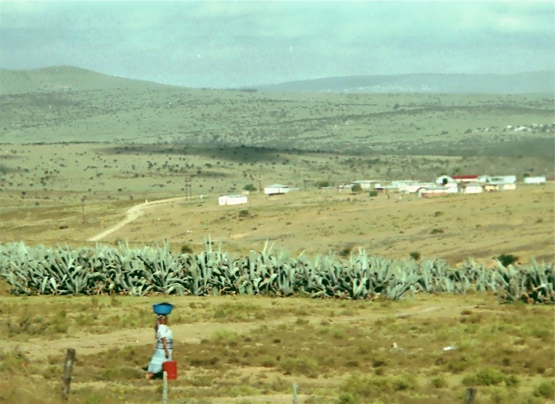
Kwezana is a village near Alice in the Tyume River valley. It is the birthplace of Archibald 'Archie' Mncedisi Sibeko, and he gives an account of life in the village in the 1930s in his book. At that time there were about 18 homesteads in the village, each consisting of a number of rondavels with walls made of wood and mud and roofs with a wooden frame, thatched with grass. One would be the kitchen and others used for sleeping. There was a separate basketwork tower for storing food. Each family had its own kraal Kraal (also spelled ''craal'' or ''kraul'') is an Afrikaans and Dutch word, also used in South African English, for an enclosure for cattle or other livestock, located within a Southern African settlement or village surrounded by a fence of th ... and the old kraals had an underground storage cellar to store maize. There were no toilets of any kind. The village was almost self-sufficient. Some families has Singer sewing machines and gramophones. There were no te ... [...More Info...] [...Related Items...] OR: [Wikipedia] [Google] [Baidu] |
1916 Births
Events Below, the events of the First World War have the "WWI" prefix. January * January 1 – The British Empire, British Royal Army Medical Corps carries out the first successful blood transfusion, using blood that had been stored and cooled. * January 9 – WWI: Gallipoli Campaign: The last British troops are evacuated from Gallipoli, as the Ottoman Empire prevails over a joint British and French operation to capture Constantinople. * January 10 – WWI: Erzurum Offensive: Russia defeats the Ottoman Empire. * January 12 – The Gilbert and Ellice Islands Colony, part of the British Empire, is established in present-day Tuvalu and Kiribati. * January 13 – WWI: Battle of Wadi (1916), Battle of Wadi: Ottoman Empire forces defeat the British, during the Mesopotamian campaign in modern-day Iraq. * January 29 – WWI: Paris is bombed by German Empire, German zeppelins. * January 31 – WWI: An attack is planned on Verdun, France. February * ... [...More Info...] [...Related Items...] OR: [Wikipedia] [Google] [Baidu] |
_ex_CGR_731.jpg)


