|
TransNamib Railway
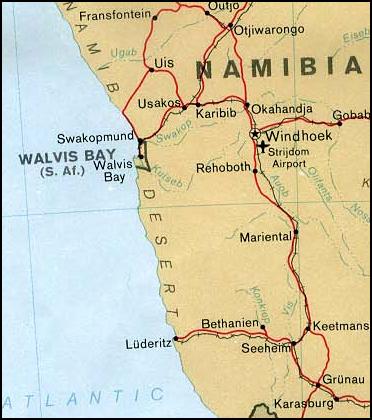
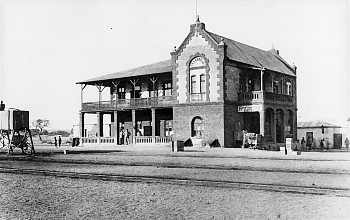
TransNamib Holdings Limited, commonly referred to as TransNamib, is a state-owned railway company in Namibia. Organised as a holding company, it provides both rail and road freight services, as well as passenger rail services. Its headquarters are in the country’s capital Windhoek. History A first local railway was constructed in 1895 by the Damaraland Guano Company for commercial purposes. The first public railway, and the core of the present system, was constructed by the German colonial government. The 383 km connection between Swakopmund and Windhoek was inaugurated on June 19, 1902. The German colonial railway was taken over by the Railways of South Africa after World War I, and linked into the network of South Africa. After the independence of Namibia, TransNamib took control of the national rail network. Operations TransNamib operated 2,883 km of rail in 1995. Since then, further track has been added to the network through the Northern Extension. It o ... [...More Info...] [...Related Items...] OR: [Wikipedia] [Google] [Baidu] |
GE U20C
The GE U20C diesel-electric locomotive was introduced by GE Transportation Systems as an export model in 1964. It was powered by the 8-cylinder List of GE reciprocating engines, 7FDL-8 engine. This locomotive is used worldwide with many variations and modifications. Different engines may be used, e.g. 7FDL8 and 7FDL12. Like the other members of the GE Universal Series locomotives, Universal series, it can be built to suit all track gauges. Indonesian U20C A unique modification is the wide cab version of the U20C used on the gauge Indonesian railroad and operated by PT Kereta Api, PT Kereta Api Indonesia (Indonesian National Railway Company). Unlike other models of the U20C, with short hood cabin, the Indonesian U20C features a full-width cabin, for comfort and better sight of track and signals. It is classified as CC203 by PT Kereta Api, PT Kereta Api Indonesia. The wide cab was built by Goninan Locomotive Work (now UGL Rail) in Australia. Construction Between 1995 and 2000, 41 ... [...More Info...] [...Related Items...] OR: [Wikipedia] [Google] [Baidu] |
Seeheim
Seeheim is a settlement in the ǁKaras Region of southern Namibia. The only notable structures in Seeheim today are the hotel and the railway station; only a handful of people live there. Seeheim belongs to the Keetmanshoop Rural electoral constituency. History Seeheim was founded in 1896 as a base for the German Schutztruppe. Early in the 20th century its sole purpose was that of a junction station where the lines from Keetmanshoop diverted to Lüderitz and Karasburg. The line Keetmanshoop-Lüderitz was built from 1905 to 1908, the line Keetmanshoop-Karasburg in 1909. The First World War was the reason to build these railway links through inhospitable land. Soon however, transport demand peaked due to the diamond rush that developed after a railway worker picked up a diamond near Grasplatz station, 24 kilometers east of Lüderitz. People travelling from the inland to Lüderitz had to stay overnight at Seeheim junction. This was the reason for the erection of two hotels, one of ... [...More Info...] [...Related Items...] OR: [Wikipedia] [Google] [Baidu] |
Angola
, national_anthem = " Angola Avante"() , image_map = , map_caption = , capital = Luanda , religion = , religion_year = 2020 , religion_ref = , coordinates = , largest_city = capital , official_languages = Portuguese , languages2_type = National languages , languages2 = , ethnic_groups = , ethnic_groups_ref = , ethnic_groups_year = 2000 , demonym = , government_type = Unitary dominant-party presidential republic , leader_title1 = President , leader_name1 = João Lourenço , leader_title2 = Vice President , leader_name2 = Esperança da CostaInvestidura do Pr ... [...More Info...] [...Related Items...] OR: [Wikipedia] [Google] [Baidu] |
Oshikango
Oshikango is a former village in northern Namibia and since 2004 part of the town of Helao Nafidi, although it still maintained its own village council for a number of years. ''Oshikango'' is still the name of the border post with Angola and the electoral constituency for this suburb. It is estimated to have grown from "a tiny cluster of shebeens around an open market into a thriving boomtown with around 5,000 to 8,000 inhabitants over a period of 10 years". History The Oshikango area was heavily affected by the 1966 to 1989 South African Border War between South Africa and its allied forces (mainly UNITA) and the Angolan government and the South West Africa People's Organisation (SWAPO). The war ended with South Africa agreeing to Namibian independence. In 1996 Oshikango, along with many other settlements in the area, was proclaimed a village with the aim of increasing border trade. Economy The border post between Namibia and Angola has brought business opportunities to Oshika ... [...More Info...] [...Related Items...] OR: [Wikipedia] [Google] [Baidu] |
Ondangwa
Ondangwa (earlier spelling ''Ondangua'') is a town in the Oshana Region of northern Namibia, bordering the Oshikoto Region. Ondangwa was first established as a mission station of the Finnish Missionary Society (the FMS) in 1890. In 1914, it became a local seat of government. Ondangwa is said to mean ''the end of the Ondonga area''. ( Ondonga is one of the kingdoms of Ovamboland), and Ondangwa is located on the western edge of this kingdom. Ondangwa is located about from the Angolan border, along the B1 road. It is one of the places of residence of the Kings of Ondonga; the current King Eliphas Kauluma, father to the reigning king, lives here. Most of the residents of the town speak Oshindonga. Ondangwa is the district capital of the Ondangwa electoral constituency. Economy and infrastructure Ondangwa features various shopping centre, a large open market, and several tourism facilities. There are also shopping centres such as Gwashamba mall, Yetu complex, Ondangwa Industr ... [...More Info...] [...Related Items...] OR: [Wikipedia] [Google] [Baidu] |
Tsumeb
, nickname = , settlement_type = City , motto = ''Glück Auf'' (German language, German for ''Good luck'') , image_skyline = Welcome to tsumeb.jpg , imagesize = , image_caption = , image_flag = , flag_size = , image_seal = , seal_size = , image_shield = Tsumeb COA.svg , shield_size = , image_blank_emblem = , blank_emblem_type = , blank_emblem_size = , image_map = , mapsize = , map_caption = , pushpin_map = Namibia , pushpin_label_position = bottom , pushpin_mapsize = 240 , pushpin_map_caption = Location in Namibia , subdivision_type = Country , subdivision_name = , subdivision_type1 = Regions of Namibia, Region , subdivision_name1 = Oshikoto Region , subdivision_type2 = Constituencies of Namibia, Constituency , subdivision_name2 = ... [...More Info...] [...Related Items...] OR: [Wikipedia] [Google] [Baidu] |
Otjiwarongo
Otjiwarongo ( hz, beautiful place) is a city of 28,000 inhabitants in the Otjozondjupa Region of Namibia. It is the district capital of the Otjiwarongo electoral constituency and also the capital of Otjozondjupa. Otjiwarongo is situated in central-north Namibia on the TransNamib railway. It is the biggest business centre for Otjozondjupa Region. Otjiwarongo is located on the B1 road and its links between Windhoek, the Golden Triangle of Otavi, Tsumeb and Grootfontein, and Etosha National Park. It is one of Namibia's fast-growing towns, with a neat and peaceful quality environment and many excellent facilities, including supermarkets, banks, lodges, and hotels. Some of Namibia's best-known private game farms and nature reserves are located in and around the town. Otjiwarongo is one of Namibia's towns with a large population of German-speaking people. German influence is also evident in its Germanic buildings. The school "Donatus School Otjiwarongo" (D.S.O.) was once known as ... [...More Info...] [...Related Items...] OR: [Wikipedia] [Google] [Baidu] |
Omaruru, Namibia
Omaruru is a city in the Erongo Region of central Namibia. The town has 14,000 inhabitants and owns of land. It is situated near Mount Erongo, on the usually dry Omaruru River. It is located on the main paved road from Swakopmund to Otjiwarongo. The name in the Otjiherero language means 'bitter milk', as Herero cattle herds used to graze on a local bush that turned their milk bitter. Omaruru is known for its annual festival where the Herero people commemorate their past local chiefs, its winery, and for the dinosaur footprints at nearby Otjihaenamparero. History Omaruru was established in 1863 by Wilhelm Zeraua, the first chief of the ''White Flag'' clan of the OvaHerero people. In 1871, Anders Ohlsson and Axel Eriksson established a brewery at Omaruru. Eriksson had also established a trading post, which flourished and by 1878 he employed about forty whites. Eriksson's business was based upon long-distance trading between southern Angola and Cape Colony, which necessitated ... [...More Info...] [...Related Items...] OR: [Wikipedia] [Google] [Baidu] |
Walvis Bay
Walvis Bay ( en, lit. Whale Bay; af, Walvisbaai; ger, Walfischbucht or Walfischbai) is a city in Namibia and the name of the bay on which it lies. It is the second largest city in Namibia and the largest coastal city in the country. The city covers a total area of of land. The bay is a safe haven for sea vessels because of its natural deepwater harbour, protected by the Pelican Point sand spit, being the only natural harbour of any size along the country's coast. Being rich in plankton and marine life, these waters also drew large numbers of southern right whales, attracting whalers and fishing vessels. A succession of colonists developed the location and resources of this strategic harbour settlement. The harbour's value in relation to the sea route around the Cape of Good Hope had caught the attention of world powers since it was discovered by the outside world in 1485. This explains the complicated political status of Walvis Bay down the years. The town is situated ... [...More Info...] [...Related Items...] OR: [Wikipedia] [Google] [Baidu] |
Karibib
, nickname = , settlement_type = Town , motto = , image_skyline =Karibib aerial view.jpg , imagesize =300 , image_caption =Karibib aerial view 2017 , image_flag = , flag_size = , image_seal = , seal_size = , image_shield = , shield_size = , image_blank_emblem = , blank_emblem_type = , blank_emblem_size = , image_map = , mapsize = , map_caption = , pushpin_map = Namibia , pushpin_label_position =bottom , pushpin_mapsize =300 , pushpin_map_caption =Location in Namibia , subdivision_type = Country , subdivision_name = , subdivision_type1 = Region , subdivision_name1 = Erongo Region , subdivision_type2 = Constituency , subdivision_name2 = Karibib Constituency , subdivision_type3 = , subdivision_name3 = , government_footnotes = , ... [...More Info...] [...Related Items...] OR: [Wikipedia] [Google] [Baidu] |
Okahandja
Okahandja is a city of 24,100 inhabitants in Otjozondjupa Region, central Namibia, and the district capital of the Okahandja electoral constituency. It is known as the ''Garden Town of Namibia''. It is located 70 km north of Windhoek on the B1 road. It was founded around 1800, by two local groups, the Herero and the Nama. History Okahandja means ''the place where two rivers'' (Okakango and Okamita) ''flow into each other to form one wide one'' in Otjiherero. A German pastor, Heinrich Schmelen, became the first European to visit the town in 1827. In 1844, two missionaries were permanently assigned to the town, Heinrich Kleinschmidt and Hugo Hahn. A church dates from this period. A military post was established at the initiative of Theodor Leutwein in 1894, and it is this date that is officially recognized as the town's founding.Okahandja Hist ... [...More Info...] [...Related Items...] OR: [Wikipedia] [Google] [Baidu] |


.jpg)


