|
Croftfoot Railway Station
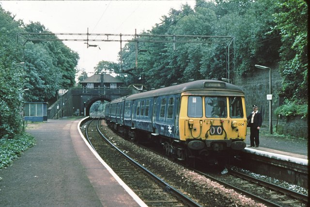
, symbol_location = gb , symbol = rail , image = Croftfoot Railway Station (geograph 3241405).jpg , caption = Croftfoot railway station, looking west , borough = South Lanarkshire , country = Scotland , coordinates = , grid_name = Grid reference , grid_position = , manager = ScotRail , platforms = 2 , code = CFF , original = London, Midland and Scottish Railway , postgroup = , years = , events = Station opened , mpassengers = , footnotes = Passenger statistics from the Office of Rail and Road Croftfoot railway station is a railway station in South Lanarkshire that lies close to the City of Glasgow / South Lanarkshire boundary serving the Croftfoot area of the City of Glasgow and the Spittal and Bankhead areas of the town of Rutherglen, Scotland. The station is managed by ScotRail and is on the Newton branch of the Cathcart Circle Line The Cathcart Circle Lines form a mostly suburban railway route linking Glasgow (Central) to Cathcart via a circu ... [...More Info...] [...Related Items...] OR: [Wikipedia] [Google] [Baidu] |
South Lanarkshire
gd, Siorrachd Lannraig a Deas , image_skyline = , image_flag = , image_shield = Arms_slanarkshire.jpg , image_blank_emblem = Slanarks.jpg , blank_emblem_type = Council logo , image_map = , map_caption = , coordinates = , seat_type = Admin HQ , seat = Hamilton , government_footnotes = , governing_body = South Lanarkshire Council , leader_title = Control , leader_name = Labour minority (council NOC) , leader_title1 = MPs , leader_name1 = *David Mundell (Dumfriesshire, Clydesdale and Tweeddale) *Lisa Cameron ( East Kilbride, Strathaven and Lesmahagow) *Angela Crawley (Lanark and Hamilton East) *Margaret Ferrier (Rutherglen and Hamilton West) , subdivision_type = Sovereign state , subdivision_name = United Kingdom , subdivision_type1 = , subdivisio ... [...More Info...] [...Related Items...] OR: [Wikipedia] [Google] [Baidu] |
Scotland
Scotland (, ) is a country that is part of the United Kingdom. Covering the northern third of the island of Great Britain, mainland Scotland has a border with England to the southeast and is otherwise surrounded by the Atlantic Ocean to the north and west, the North Sea to the northeast and east, and the Irish Sea to the south. It also contains more than 790 islands, principally in the archipelagos of the Hebrides and the Northern Isles. Most of the population, including the capital Edinburgh, is concentrated in the Central Belt—the plain between the Scottish Highlands and the Southern Uplands—in the Scottish Lowlands. Scotland is divided into 32 administrative subdivisions or local authorities, known as council areas. Glasgow City is the largest council area in terms of population, with Highland being the largest in terms of area. Limited self-governing power, covering matters such as education, social services and roads and transportation, is devolved from the Scott ... [...More Info...] [...Related Items...] OR: [Wikipedia] [Google] [Baidu] |
Railway Stations In Great Britain Opened In 1931
Rail transport (also known as train transport) is a means of transport that transfers passengers and goods on wheeled vehicles running on rails, which are incorporated in tracks. In contrast to road transport, where the vehicles run on a prepared flat surface, rail vehicles (rolling stock) are directionally guided by the tracks on which they run. Tracks usually consist of steel rails, installed on sleepers (ties) set in ballast, on which the rolling stock, usually fitted with metal wheels, moves. Other variations are also possible, such as "slab track", in which the rails are fastened to a concrete foundation resting on a prepared subsurface. Rolling stock in a rail transport system generally encounters lower frictional resistance than rubber-tyred road vehicles, so passenger and freight cars (carriages and wagons) can be coupled into longer trains. The operation is carried out by a railway company, providing transport between train stations or freight customer facili ... [...More Info...] [...Related Items...] OR: [Wikipedia] [Google] [Baidu] |
Former London, Midland And Scottish Railway Stations
A former is an object, such as a template, gauge or cutting die, which is used to form something such as a boat's hull. Typically, a former gives shape to a structure that may have complex curvature. A former may become an integral part of the finished structure, as in an aircraft fuselage, or it may be removable, being using in the construction process and then discarded or re-used. Aircraft formers Formers are used in the construction of aircraft fuselage, of which a typical fuselage has a series from the nose to the empennage, typically perpendicular to the longitudinal axis of the aircraft. The primary purpose of formers is to establish the shape of the fuselage and reduce the column length of stringers to prevent instability. Formers are typically attached to longerons, which support the skin of the aircraft. The "former-and-longeron" technique (also called stations and stringers) was adopted from boat construction, and was typical of light aircraft built until the ... [...More Info...] [...Related Items...] OR: [Wikipedia] [Google] [Baidu] |
Buildings And Structures In Rutherglen
A building, or edifice, is an enclosed structure with a roof and walls standing more or less permanently in one place, such as a house or factory (although there's also portable buildings). Buildings come in a variety of sizes, shapes, and functions, and have been adapted throughout history for a wide number of factors, from building materials available, to weather conditions, land prices, ground conditions, specific uses, prestige, and aesthetic reasons. To better understand the term ''building'' compare the list of nonbuilding structures. Buildings serve several societal needs – primarily as shelter from weather, security, living space, privacy, to store belongings, and to comfortably live and work. A building as a shelter represents a physical division of the human habitat (a place of comfort and safety) and the ''outside'' (a place that at times may be harsh and harmful). Ever since the first cave paintings, buildings have also become objects or canvasses of much artistic ... [...More Info...] [...Related Items...] OR: [Wikipedia] [Google] [Baidu] |
Railway Stations In South Lanarkshire
Rail transport (also known as train transport) is a means of transport that transfers passengers and goods on wheeled vehicles running on rails, which are incorporated in tracks. In contrast to road transport, where the vehicles run on a prepared flat surface, rail vehicles (rolling stock) are directionally guided by the tracks on which they run. Tracks usually consist of steel rails, installed on sleepers (ties) set in ballast, on which the rolling stock, usually fitted with metal wheels, moves. Other variations are also possible, such as "slab track", in which the rails are fastened to a concrete foundation resting on a prepared subsurface. Rolling stock in a rail transport system generally encounters lower frictional resistance than rubber-tyred road vehicles, so passenger and freight cars (carriages and wagons) can be coupled into longer trains. The operation is carried out by a railway company, providing transport between train stations or freight customer facilit ... [...More Info...] [...Related Items...] OR: [Wikipedia] [Google] [Baidu] |
Cathcart Circle Lines
The Cathcart Circle Lines form a mostly suburban railway route linking Glasgow (Central) to Cathcart via a circular line, with branches to Newton and Neilston, on the south bank of the River Clyde. They are part of the Strathclyde Partnership for Transport network. History The lines were built by the Cathcart District Railway (Cathcart Circle) and the Lanarkshire and Ayrshire Railway (Newton and Neilston lines). The first part opened on 1 March 1886 as a double line from Glasgow Central to then single to Cathcart, doubled on 26 May 1886. The circular route back to Central station via Shawlands and Maxwell Park was completed on 2 April 1894. The Newton and Neilston branches were built to provide a through route from the Lanarkshire coalfields to ports such as Ardrossan on the Ayrshire coast. There is still a junction with other lines at Newton, but the track beyond Neilston has been lifted. The lines originally carried significant amounts of freight, but commuter trains ... [...More Info...] [...Related Items...] OR: [Wikipedia] [Google] [Baidu] |
Newton (Lanark) Railway Station
, symbol_location = gb , symbol = rail , image = Newton railway station (geograph 3751384).jpg , borough = Cambuslang, South Lanarkshire , country = Scotland , coordinates = , grid_name = Grid reference , grid_position = , manager = ScotRail Trains , platforms = 2 , code = NTN , transit_authority = Strathclyde Partnership for Transport , original = Clydesdale Junction Railway , pregroup = Caledonian Railway , postgroup = LMS , years = 1 June 1849 , events = Original station opened , years1 = 19 December 1873 , events1 = Closed; new station opened , mpassengers = , footnotes = Passenger statistics from the Office of Rail and Road Newton railway station is a railway station located between the neighbourhoods of Drumsagard, Halfway, Newton and Westburn in the town of Cambuslang (Greater Glasgow), Scotland. The station is managed by ScotRail on the Argyle and Cathcart Circle Lines. History The original Newton station was opened as part of the Clyd ... [...More Info...] [...Related Items...] OR: [Wikipedia] [Google] [Baidu] |
Rutherglen
Rutherglen (, sco, Ruglen, gd, An Ruadh-Ghleann) is a town in South Lanarkshire, Scotland, immediately south-east of the city of Glasgow, from its centre and directly south of the River Clyde. Having existed as a Lanarkshire burgh in its own right for more than 800 years, in 1975 Rutherglen lost its own local council and administratively became a component of the City of Glasgow (1975–1996), City of Glasgow District within the Strathclyde Local government areas of Scotland 1973–96, region (along with neighbouring Cambuslang). In 1996 the towns were reallocated to the South Lanarkshire Subdivisions of Scotland, council area.From a pawnbrokers to Parliament - Tommy McAvoy looks back on a career that too ... [...More Info...] [...Related Items...] OR: [Wikipedia] [Google] [Baidu] |
Ordnance Survey National Grid
The Ordnance Survey National Grid reference system (OSGB) (also known as British National Grid (BNG)) is a system of geographic grid references used in Great Britain, distinct from latitude and longitude. The Ordnance Survey (OS) devised the national grid reference system, and it is heavily used in their survey data, and in maps based on those surveys, whether published by the Ordnance Survey or by commercial map producers. Grid references are also commonly quoted in other publications and data sources, such as guide books and government planning documents. A number of different systems exist that can provide grid references for locations within the British Isles: this article describes the system created solely for Great Britain and its outlying islands (including the Isle of Man); the Irish grid reference system was a similar system created by the Ordnance Survey of Ireland and the Ordnance Survey of Northern Ireland for the island of Ireland. The Universal Transverse Merca ... [...More Info...] [...Related Items...] OR: [Wikipedia] [Google] [Baidu] |
Croftfoot
Croftfoot ( sco, Croaftfuit, gd, Bun a' Chroit) is a residential area on the southeastern side of the Scottish city of . It is bordered by to the south and King's Park (both the public park and the residential neighbourhood) to the west within Glasgow, and by the |


.jpg)