|
Coed Nant Menascin
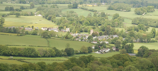
Coed Nant Menascin is a Site of Special Scientific Interest (SSSI), around the Nant Menasgin, near Llanfrynach in the Brecon Beacons National Park, Powys, Wales. () The Cwm Oergwm Nature Reserve of the Brecknock Wildlife Trust forms a large part of the site. The site comprises semi-natural woodland in the steep wooded valley of the Nant Menascin (Menasgin), on the north-east slopes of the Brecon Beacons. The woodland supports a wide variety of higher and lower plants. Access is restricted, except for the public footpaths that cross the site. References See also *List of Sites of Special Scientific Interest in Brecknock SSSIs in the UK are notified using the concept of an Area of Search (AOS), an area of between and in size. The Areas of Search were conceived and developed between 1975 and 1979 by the Nature Conservancy Council (NCC), based on regions create ... Sites of Special Scientific Interest in Brecknock Brecon Beacons {{Powys-geo-stub ... [...More Info...] [...Related Items...] OR: [Wikipedia] [Google] [Baidu] |
Site Of Special Scientific Interest
A Site of Special Scientific Interest (SSSI) in Great Britain or an Area of Special Scientific Interest (ASSI) in the Isle of Man and Northern Ireland is a conservation designation denoting a protected area in the United Kingdom and Isle of Man. SSSI/ASSIs are the basic building block of site-based nature conservation legislation and most other legal nature/geological conservation designations in the United Kingdom are based upon them, including national nature reserves, Ramsar sites, Special Protection Areas, and Special Areas of Conservation. The acronym "SSSI" is often pronounced "triple-S I". Selection and conservation Sites notified for their biological interest are known as Biological SSSIs (or ASSIs), and those notified for geological or physiographic interest are Geological SSSIs (or ASSIs). Sites may be divided into management units, with some areas including units that are noted for both biological and geological interest. Biological Biological SSSI/ASSIs may ... [...More Info...] [...Related Items...] OR: [Wikipedia] [Google] [Baidu] |
Nant Menasgin
The Nant Menasgin is a short river in Powys, Wales whose headwaters rise in Cwm Oergwm, beneath Fan y Bîg, in the central Brecon Beacons, and flow northeastwards via Llanfrynach, to join the River Usk at Pencelli. The stream in Cwm Oergwm is joined by that from Cwm Cwareli within woodland owned by the National Trust. Above Llanfrynach, much of the length of the river is paralleled by bridleways affording some degree of visibility to the public. The first vehicle bridge to cross the river is Llanfrynach Bridge which also carries the route of the Taff Trail. A further downstream the Monmouthshire and Brecon Canal crosses by means of an aqueduct and a third bridge conveys the B4558 road The B4558 road is a road in Powys, central Wales, with a total length of . It begins at a junction with the A4077 road across the Usk bridge from Crickhowell and runs northwest up the southern side of the Usk valley to a junction with the A40 ... just northwest of Pencelli.Ordnance Survey Exp ... [...More Info...] [...Related Items...] OR: [Wikipedia] [Google] [Baidu] |
Llanfrynach
Llanfrynach is a village and community in the county of Powys, Wales, and the historic county of Brecknockshire. The population of the community as taken at the 2011 census was 571. It lies just to the southeast of Brecon in the Brecon Beacons National Park. The village sits astride the Nant Menasgin, a right bank tributary of the River Usk. The B4558 passes just to its north and the Monmouthshire and Brecon Canal also passes around the village. The Welsh name signifies the 'church of Brynach'. The community includes the hamlets of Llanhamlach and Groesffordd. The Cefn Brynich Canal Bridge Aqueduct over the Usk is a Grade II* listed structure. The community is included in the Talybont-on-Usk electoral ward, which chooses one county councillor for Powys County Council Powys County Council ( cy, Cyngor Sir Powys) is the local authority for Powys, one of the administrative areas of Wales. The County Hall is in Llandrindod Wells. History The county of Powys was created o ... [...More Info...] [...Related Items...] OR: [Wikipedia] [Google] [Baidu] |
Brecon Beacons National Park
The Brecon Beacons National Park ( cy, Parc Cenedlaethol Bannau Brycheiniog) is one of three national parks in Wales, and is centred on the Brecon Beacons range of hills in southern Wales. It includes the Black Mountain (range), Black Mountain ( cy, Y Mynydd Du) in the west, Fforest Fawr (translates as 'great forest') and the Brecon Beacons in the centre and the Black Mountains, Wales, Black Mountains ( cy, Y Mynydd Du or Mynyddoedd Duon) in the east. Description The Brecon Beacons National Park was established in 1957, the last of the three Welsh parks designated after Snowdonia in 1951 and the Pembrokeshire Coast in 1952. It stretches from Llandeilo in the west to Hay-on-Wye in the northeast and Pontypool in the southeast, covering and encompassing four main regions – the Black Mountain (range), Black Mountain in the west, reaching 802 metres (2631 feet) at Fan Brycheiniog, Fforest Fawr and the Brecon Beacons in the centre, including the highest summit in the park and in ... [...More Info...] [...Related Items...] OR: [Wikipedia] [Google] [Baidu] |
Powys
Powys (; ) is a Local government in Wales#Principal areas, county and Preserved counties of Wales, preserved county in Wales. It is named after the Kingdom of Powys which was a Welsh succession of states, successor state, petty kingdom and principality that emerged during the Middle Ages following the end of Roman rule in Britain. Geography Powys covers the historic counties of Montgomeryshire and Radnorshire, most of Brecknockshire, and part of Denbighshire (historic), historic Denbighshire. With an area of about , it is now the largest administrative area in Wales by land and area (Dyfed was until 1996 before several Preserved counties of Wales, former counties created by the Local Government Act 1972 were abolished). It is bounded to the north by Gwynedd, Denbighshire and Wrexham County Borough; to the west by Ceredigion and Carmarthenshire; to the east by Shropshire and Herefordshire; and to the south by Rhondda Cynon Taf, Merthyr Tydfil County Borough, Caerphilly County Bor ... [...More Info...] [...Related Items...] OR: [Wikipedia] [Google] [Baidu] |
Brecknock Wildlife Trust
Brecknock Wildlife Trust ( cy, Ymddiriedolaeth Natur Sir Frycheiniog) is a former wildlife trust covering the vice county of Brecknockshire in Wales. The Trust was founded in 1964, with a network of volunteers carrying out most of its work. No full-time conservation officers were in post until 1987. Heritage Lottery funding helped the Trust to expand and a bequest of £1,000,000 in 2003 resulted in the appointment of a Reserves Officer. In April 2018 it merged with The Wildlife Trust of South and West Wales. The offices of the Trust are located in Lion House, Brecon. The Trust has 22 reserves, the majority of which are in the Brecon Beacons National Park. All are open to the public free of charge. The most visited of the reserves is at Pwll-y-Wrach ("Witches' Pool", near Talgarth; the site is 17.5 hectares in area, most of which is woodland. At the eastern end of the reserve is a waterfall flowing from the River Enig into the so-called Witches' Pool. The wildlife in this a ... [...More Info...] [...Related Items...] OR: [Wikipedia] [Google] [Baidu] |
Brecon Beacons
The Brecon Beacons ( cy, Bannau Brycheiniog, ) are a mountain range in South Wales. In a narrow sense, the name refers to the range of Old Red Sandstone peaks which lie to the south of Brecon. Sometimes referred to as "the central Beacons" they include South Wales' highest mountain, Pen y Fan. The range forms the central section of the Brecon Beacons National Park (), a designation which also encompasses ranges both to the east and the west of "the central Beacons". This much wider area is also commonly referred to as "the Brecon Beacons", and it includes the Black Mountains to the east as well as the similarly named but quite distinct Black Mountain to the west. The highest peaks include Fan Brycheiniog to the west and Pen y Fan in the central part. They share the same basic geology as the central range, and so exhibit many similar features, such as the north-facing escarpment and glacial features such as lakes and cwms ( cirques). Geography The Brecon Beacons range, in ... [...More Info...] [...Related Items...] OR: [Wikipedia] [Google] [Baidu] |
Vascular Plant
Vascular plants (), also called tracheophytes () or collectively Tracheophyta (), form a large group of land plants ( accepted known species) that have lignified tissues (the xylem) for conducting water and minerals throughout the plant. They also have a specialized non-lignified tissue (the phloem) to conduct products of photosynthesis. Vascular plants include the clubmosses, horsetails, ferns, gymnosperms (including conifers), and angiosperms (flowering plants). Scientific names for the group include Tracheophyta, Tracheobionta and Equisetopsida ''sensu lato''. Some early land plants (the rhyniophytes) had less developed vascular tissue; the term eutracheophyte has been used for all other vascular plants, including all living ones. Historically, vascular plants were known as "higher plants", as it was believed that they were further evolved than other plants due to being more complex organisms. However, this is an antiquated remnant of the obsolete scala naturae, and the term ... [...More Info...] [...Related Items...] OR: [Wikipedia] [Google] [Baidu] |
Non-vascular Plant
Non-vascular plants are plants without a vascular system consisting of xylem and phloem. Instead, they may possess simpler tissues that have specialized functions for the internal transport of water. Non-vascular plants include two distantly related groups: * Bryophytes, an informal group that taxonomists treat as three separate land-plant divisions, namely: Bryophyta (mosses), Marchantiophyta (liverworts), and Anthocerotophyta (hornworts). In all bryophytes, the primary plants are the haploid gametophytes, with the only diploid portion being the attached sporophyte, consisting of a stalk and sporangium. Because these plants lack lignified water-conducting tissues, they can't become as tall as most vascular plants. * Algae, especially green algae. The algae consist of several unrelated groups. Only the groups included in the Viridiplantae are still considered relatives of land plants. These groups are sometimes called "lower plants", referring to their status as the earliest pl ... [...More Info...] [...Related Items...] OR: [Wikipedia] [Google] [Baidu] |
Rights Of Way In England And Wales
In England and Wales, other than in the 12 Inner London London boroughs, boroughs and the City of London, the right of way is a legally protected right of the public to pass and re-pass on specific paths. The law in England and Wales differs from Scots law in that rights of way exist only where they are so designated (or are able to be designated if not already), whereas in Scotland any route that meets certain conditions is rights of way in Scotland, defined as a right of way, and in addition, there is a general presumption of access to the countryside ("right to roam"). Private rights of way or easements also exist (see also Highways in England and Wales). Inner London Definitive maps of public rights of way have been compiled for all of England and Wales, as a result of the National Parks and Access to the Countryside Act 1949, except the 12 Inner London boroughs, which, along with the City of London, were not covered by the Act. Definitive maps exist for the Outer London bo ... [...More Info...] [...Related Items...] OR: [Wikipedia] [Google] [Baidu] |
List Of Sites Of Special Scientific Interest In Brecknock
SSSIs in the UK are notified using the concept of an Area of Search (AOS), an area of between and in size. The Areas of Search were conceived and developed between 1975 and 1979 by the Nature Conservancy Council (NCC), based on regions created by the Local Government Act 1972.Joint Nature Conservation Committee (1998 revision); ''Guidelines for the Selection of Biological SSSIs'', section 4.5, pp. 14–15. . Whereas England had its Areas of Search based on 46 counties, those in Wales were based on a combination of the counties and smaller districts. In 1974, Wales was divided into 8 counties, with 37 districts. The NCC created 12 Welsh Areas of Search; they mostly follow county borders, but the larger counties (Dyfed, Powys and Gwynedd) were divided into multiple Areas using district borders. Mid and South Glamorgan were merged into a single AOS, whilst Llanelli district was included in the West Glamorgan AOS. Due to subsequent local government reorganisation in the UK since ... [...More Info...] [...Related Items...] OR: [Wikipedia] [Google] [Baidu] |
Sites Of Special Scientific Interest In Brecknock
Site most often refers to: * Archaeological site * Campsite, a place used for overnight stay in an outdoor area * Construction site * Location, a point or an area on the Earth's surface or elsewhere * Website, a set of related web pages, typically with a common domain name It may also refer to: * Site, a National Register of Historic Places property type * SITE (originally known as ''Sculpture in the Environment''), an American architecture and design firm * Site (mathematics), a category C together with a Grothendieck topology on C * ''The Site'', a 1990s TV series that aired on MSNBC * SITE Intelligence Group, a for-profit organization tracking jihadist and white supremacist organizations * SITE Institute, a terrorism-tracking organization, precursor to the SITE Intelligence Group * Sindh Industrial and Trading Estate, a company in Sindh, Pakistan * SITE Centers, American commercial real estate company * SITE Town, a densely populated town in Karachi, Pakistan * S.I.T.E Indust ... [...More Info...] [...Related Items...] OR: [Wikipedia] [Google] [Baidu] |


