|
Citarum
The Citarum River ( su, Walungan Citarum) is the longest and largest river in West Java, Indonesia. It is the third longest river in Java, after Bengawan Solo and Brantas. It plays an important role in the life of the people of West Java. It has been noted for being considered one of the most polluted rivers in the world. History In Indonesian history the Citarum is linked with the 4th-century Tarumanagara kingdom, as the kingdom and the river shared the same etymology, derived from the word "tarum" (Sundanese for indigo plant). The earlier 4th-century BCE prehistoric Buni clay pottery-making culture flourished near the river's mouth. Stone inscriptions, Chinese sources, and archaeological sites such as Batujaya and Cibuaya suggest that human habitation and civilization flourished in and around the river estuaries and river valley as early as the 4th century and even earlier. Geography The river flows in the northwest area of Java with a predominantly tropical monsoon climate ... [...More Info...] [...Related Items...] OR: [Wikipedia] [Google] [Baidu] |
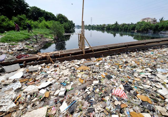
Citarum River Pollution, 2009
The Citarum River ( su, Walungan Citarum) is the longest and largest river in West Java, Indonesia. It is the third longest river in Java, after Bengawan Solo and Brantas. It plays an important role in the life of the people of West Java. It has been noted for being considered one of the most polluted rivers in the world. History In Indonesian history the Citarum is linked with the 4th-century Tarumanagara kingdom, as the kingdom and the river shared the same etymology, derived from the word "tarum" (Sundanese for indigo plant). The earlier 4th-century BCE prehistoric Buni clay pottery-making culture flourished near the river's mouth. Stone inscriptions, Chinese sources, and archaeological sites such as Batujaya and Cibuaya suggest that human habitation and civilization flourished in and around the river estuaries and river valley as early as the 4th century and even earlier. Geography The river flows in the northwest area of Java with a predominantly tropical monsoon climate ... [...More Info...] [...Related Items...] OR: [Wikipedia] [Google] [Baidu] |
Tarumanagara
Tarumanagara or Taruma Kingdom or just Taruma is an early Sundanese Indianised kingdom, located in western Java, whose 5th-century ruler, Purnawarman, produced the earliest known inscriptions in Java, which are estimated to date from around 450 CE. At least seven stone inscriptions connected to this kingdom were discovered in Western Java area, near Bogor and Jakarta. They are Ciaruteun, Kebon Kopi, Jambu, Pasir Awi, and Muara Cianten inscriptions near Bogor; Tugu inscription near Cilincing in North Jakarta; and Cidanghiang inscription in Lebak village, Munjul district, south of Banten. Location The inscriptions of Taruma kingdom are the earliest records of Hinduism in the western part of the archipelago. The geographical position of coastal West Java, which corresponds to today modern Jakarta, is a commanding region that controls the Sunda Strait. This location is strategic in regard to Sumatra, and also its connection to Asian continent of India and China. The kingdom ... [...More Info...] [...Related Items...] OR: [Wikipedia] [Google] [Baidu] |
Bandung
Bandung ( su, ᮘᮔ᮪ᮓᮥᮀ, Bandung, ; ) is the capital city of the Indonesian province of West Java. It has a population of 2,452,943 within its city limits according to the official estimates as at mid 2021, making it the fourth most populous city in Indonesia. Greater Bandung (Bandung Basin Metropolitan Area/BBMA) is the country's third-largest metropolitan area, with nearly nine million inhabitants. Located above sea level, the highest point in the North area with an altitude of 1,050 meters and the lowest in the South is 675 meters above sea level, approximately southeast of Jakarta, Bandung has cooler year-round temperatures than most other Indonesian cities. The city lies on a river basin surrounded by volcanic mountains that provides a natural defence system, which was the primary reason for the Dutch East Indies government's plan to move the capital from Batavia (modern-day Jakarta) to Bandung. The Dutch first established tea plantations around the mou ... [...More Info...] [...Related Items...] OR: [Wikipedia] [Google] [Baidu] |
Saguling Dam
The Saguling Dam is an embankment dam on the headwater of Citarum River in West Java, Indonesia Indonesia, officially the Republic of Indonesia, is a country in Southeast Asia and Oceania between the Indian and Pacific oceans. It consists of over 17,000 islands, including Sumatra, Java, Sulawesi, and parts of Borneo and New Guine .... It is located west of Bandung. Construction began in 1983. The reservoir had filled by 1985 and the first generator was operational in 1986. The primary purpose of the dam is hydroelectric power generation but it also provides for water supply and aquaculture. The tall dam is rock-fill embankment-type with watertight core that withholds a reservoir with a capacity of . Its power station has 4 x 175 MW Francis turbine generators with an installed capacity of 700 MW. Including land acquisition, the cost of the dam with power plant was about $US 663 million. The installed capacity of the power plant might be expanded to 1,400 MW in th ... [...More Info...] [...Related Items...] OR: [Wikipedia] [Google] [Baidu] |
Cirata Dam
The Cirata Dam is an embankment dam on the Citarum River in West Java, Indonesia. It is located southeast of Jakarta. It was constructed between 1984 and 1988 for the primary purpose of hydroelectric power generation. Other purposes include flood control, aquaculture, water supply and irrigation. The tall concrete-face rock-fill dam is situated just before a sharp bend in the river and withholds a reservoir with a gross storage capacity of . The reservoir has a surface area of which caused the relocation of 6,335 families. The dam's power station is located on the north side of the river bend and contains eight 126 MW Francis turbine-generators. It has a total installed capacity of 1,008 MW and an annual generation of 1,426 GWh. The power station was completed in two phases, the second was completed in 1998. It serves mostly as a peaking power plant and is the largest hydroelectric power station in Indonesia. The construction of the dam resulted in involuntary resettlement of 56, ... [...More Info...] [...Related Items...] OR: [Wikipedia] [Google] [Baidu] |
Jatiluhur Dam
The Jatiluhur Dam is a multi-purpose embankment dam on the Citarum River in West Java, Indonesia. It is located east of Jakarta, close to the medium-size town of Purwakarta. Jatiluhur Dam was designed by Coyne et Bellier and was constructed between 1957 and 1965 while the power station become operational in 1967. The dam serves several purposes including the provision of hydroelectric power generation, water supply, flood control, irrigation and aquaculture. The power station has an installed capacity of 186.5 MW which feeds into the Java grid managed by the state-owned electricity company ''Perusahaan Listrik Negara''. The Jatiluhur reservoir helps irrigate of rice fields. The earth-fill dam is high and withholds a reservoir of , the largest in the country. See also *List of power stations in Indonesia The following lists some of the larger power stations in Indonesia. Data are not included for a large number of small isolated plants (mostly diesel) in the Outer Islands. In ... [...More Info...] [...Related Items...] OR: [Wikipedia] [Google] [Baidu] |
Java
Java (; id, Jawa, ; jv, ꦗꦮ; su, ) is one of the Greater Sunda Islands in Indonesia. It is bordered by the Indian Ocean to the south and the Java Sea to the north. With a population of 151.6 million people, Java is the world's List of islands by population, most populous island, home to approximately 56% of the Demographics of Indonesia, Indonesian population. Indonesia's capital city, Jakarta, is on Java's northwestern coast. Many of the best known events in Indonesian history took place on Java. It was the centre of powerful Hindu-Buddhist empires, the Islamic sultanates, and the core of the colonial Dutch East Indies. Java was also the center of the History of Indonesia, Indonesian struggle for independence during the 1930s and 1940s. Java dominates Indonesia politically, economically and culturally. Four of Indonesia's eight UNESCO world heritage sites are located in Java: Ujung Kulon National Park, Borobudur Temple, Prambanan Temple, and Sangiran Early Man Site. ... [...More Info...] [...Related Items...] OR: [Wikipedia] [Google] [Baidu] |
Environmental Issues In Indonesia
Environmental issues in Indonesia are associated with the country's high population density and rapid industrialisation, and they are often given a lower priority due to high poverty levels, and an under-resourced governance. Most large palm oil plantations in Indonesia owned by Singaporean rich conglomerates who employ thousands of local natives Indonesian. Issues include large-scale deforestation (much of it illegal) and related wildfires causing heavy smog over parts of western Indonesia, Malaysia and Singapore; over-exploitation of marine resources; and environmental problems associated with rapid urbanisation and economic development, including air pollution, traffic congestion, garbage management, and reliable water and waste water services. Deforestation and the destruction of peatlands make Indonesia the world's third largest emitter of greenhouse gases. Habitat destruction threatens the survival of indigenous and endemic species, including 140 species of mammals id ... [...More Info...] [...Related Items...] OR: [Wikipedia] [Google] [Baidu] |
Java Sea
The Java Sea ( id, Laut Jawa, jv, Segara Jawa) is an extensive shallow sea on the Sunda Shelf, between the Indonesian islands of Borneo to the north, Java to the south, Sumatra to the west, and Sulawesi to the east. Karimata Strait to its northwest links it to the South China Sea. It is a part of the western Pacific Ocean. Geography The Java Sea covers the southern section of the Sunda Shelf. A shallow sea, it has a mean depth of . It measures about east-west by north-southGoogleEarth and occupies a total surface area of . It formed as sea levels rose at the end of the last ice age. Its almost uniformly flat bottom, and the presence of drainage channels (traceable to the mouths of island rivers), indicate that the Sunda Shelf was once a stable, dry, low-relief land area (peneplain) above which were left standing a few monadnocks (granite hills that, due to their resistance to erosion, form the present islands). Extent The International Hydrographic Organization (IHO) defi ... [...More Info...] [...Related Items...] OR: [Wikipedia] [Google] [Baidu] |
West Java
West Java ( id, Jawa Barat, su, ᮏᮝ ᮊᮥᮜᮧᮔ᮪, romanized ''Jawa Kulon'') is a province of Indonesia on the western part of the island of Java, with its provincial capital in Bandung. West Java is bordered by the province of Banten and the country's capital region of Jakarta to the west, the Java Sea to the north, the province of Central Java to the east and the Indian Ocean to the south. With Banten, this province is the native homeland of the Sundanese people, the second-largest ethnic group in Indonesia. West Java was one of the first eight provinces of Indonesia formed following the country's independence proclamation and was later legally re-established on 14 July 1950. In 1966, the city of Jakarta was split off from West Java as a 'special capital region' (), with a status equivalent to that of a province, while in 2000 the western parts of the province were in turn split away to form a separate Banten province. Even following these split-offs, West Java is ... [...More Info...] [...Related Items...] OR: [Wikipedia] [Google] [Baidu] |
Hydroelectricity
Hydroelectricity, or hydroelectric power, is Electricity generation, electricity generated from hydropower (water power). Hydropower supplies one sixth of the world's electricity, almost 4500 TWh in 2020, which is more than all other Renewable energy, renewable sources combined and also more than nuclear power. Hydropower can provide large amounts of Low-carbon power, low-carbon electricity on demand, making it a key element for creating secure and clean electricity supply systems. A hydroelectric power station that has a dam and reservoir is a flexible source, since the amount of electricity produced can be increased or decreased in seconds or minutes in response to varying electricity demand. Once a hydroelectric complex is constructed, it produces no direct waste, and almost always emits considerably less greenhouse gas than fossil fuel-powered energy plants. [...More Info...] [...Related Items...] OR: [Wikipedia] [Google] [Baidu] |
Bekasi Regency
Bekasi Regency (Indonesian language, Indonesian: Kabupaten Bekasi) is a Regencies of Indonesia, regency ''(kabupaten)'' of West Java Province, Indonesia. Its regency seat is in the district of Central Cikarang. It is bordered by Jakarta and by Bekasi City (which is a separate administration from the Regency) to the west, by Bogor Regency to the south, and by Karawang Regency to the east. This highly urbanised area (largely suburban to Jakarta to its west) has an area of and contained 2,630,401 people at the 2010 CensusBiro Pusat Statistik, Jakarta, 2011. and 3,113,017 at the 2020 Census, with an average density of . The official estimate as at mid 2021 was 3,157,962. The earliest evidence of the existence of Bekasi dates from the 5th century according to the Tugu inscription, which describes the name of two rivers that run through the city, i.e. Candrabhaga and Gomati and one of those rivers, i.e. Candrabhaga is the origin of the name Bekasi where the name Candrabhaga evolved into ... [...More Info...] [...Related Items...] OR: [Wikipedia] [Google] [Baidu] |
