|
Chehalis, British Columbia
Chehalis is a small forestry, agricultural and First Nations community in the Lower Mainland of British Columbia located on Highway 7 on the west bank of the Harrison River The Harrison River is a short but large tributary of the Fraser River, entering it near the community of Chehalis, British Columbia, Canada. The Harrison drains Harrison Lake and is the ''de facto'' continuation of the Lillooet River, which feed ... between the town of Mission and the resort community of Harrison Hot Springs. Chehalis is the site of Chehalis Indian Reserve No. 5 of the Sts'Ailes people and their government, the Chehalis First Nation. The Chehalis River enters the Harrison near the reserve community, which is on IR No. 5. Chehalis Indian Reserve No. 6 is across the Harrison from the main community, which is home to various non-native businesses as well as native-operated ones. References Unincorporated settlements in British Columbia {{BritishColumbia-geo-stub ... [...More Info...] [...Related Items...] OR: [Wikipedia] [Google] [Baidu] |
British Columbia
British Columbia (commonly abbreviated as BC) is the westernmost Provinces and territories of Canada, province of Canada, situated between the Pacific Ocean and the Rocky Mountains. It has a diverse geography, with rugged landscapes that include rocky coastlines, sandy beaches, forests, lakes, mountains, inland deserts and grassy plains, and borders the province of Alberta to the east and the Yukon and Northwest Territories to the north. With an estimated population of 5.3million as of 2022, it is Canada's Population of Canada by province and territory, third-most populous province. The capital of British Columbia is Victoria, British Columbia, Victoria and its largest city is Vancouver. Vancouver is List of census metropolitan areas and agglomerations in Canada, the third-largest metropolitan area in Canada; the 2021 Canadian census, 2021 census recorded 2.6million people in Metro Vancouver Regional District, Metro Vancouver. The First Nations in Canada, first known human inhabi ... [...More Info...] [...Related Items...] OR: [Wikipedia] [Google] [Baidu] |
Provinces And Territories Of Canada
Within the geographical areas of Canada, the ten provinces and three territories are sub-national administrative divisions under the jurisdiction of the Canadian Constitution. In the 1867 Canadian Confederation, three provinces of British North America—New Brunswick, Nova Scotia, and the Province of Canada (which upon Confederation was divided into Ontario and Quebec)—united to form a federation, becoming a fully independent country over the next century. Over its history, Canada's international borders have changed several times as it has added territories and provinces, making it the world's second-largest country by area. The major difference between a Canadian province and a territory is that provinces receive their power and authority from the '' Constitution Act, 1867'' (formerly called the '' British North America Act, 1867''), whereas territorial governments are creatures of statute with powers delegated to them by the Parliament of Canada. The powers flowing ... [...More Info...] [...Related Items...] OR: [Wikipedia] [Google] [Baidu] |
Area Code 604
Area code 604 is a telephone area code that serves southwestern British Columbia, Canada: the Lower Mainland, Sunshine Coast, Howe Sound / Sea to Sky Corridor, Fraser Valley and the lower Fraser Canyon regions. It primarily serves the city of Vancouver and surrounding regions. History Area code 604 is one of the original 86 area codes assigned in 1947 in the contiguous United States and the then-nine provinces of Canada. It served the entire province of British Columbia. Until 1988, 604 also included Point Roberts, Washington, a pene-enclave of the United States; Point Roberts was transferred in 1988 to area code 206 and is now served by area code 360. Despite British Columbia's growth in the second half of the 20th century, 604 remained the province's sole area code for nearly 50 years. By the mid-1990s, however, the need for a new area code in the province could no longer be staved off, largely because of Canada's number allocation system. Every competitive local excha ... [...More Info...] [...Related Items...] OR: [Wikipedia] [Google] [Baidu] |
Area Code 778
Area codes 778, 236, and 672 are area codes in the North American Numbering Plan (NANP) for the entire Canadian province of British Columbia. They form an overlay complex with area code 604, which serves only a small southwestern section, the Lower Mainland, of the province (including Vancouver), and area code 250, which serves the rest of the province. The area codes also serve the small United States community of Hyder, Alaska, which is located along the Canada–United States border near the town of Stewart. History Area code 604 had served as British Columbia's sole area code for 53 years since the establishment of the North American Numbering Plan in 1947. In 1997, area code 250 was installed for Vancouver Island and the Interior, while area code 604 was restricted to serve Vancouver and the Lower Mainland. Intended as a long-term solution, the proliferation of telephone service in the area required additional central office code relief within only four years. While t ... [...More Info...] [...Related Items...] OR: [Wikipedia] [Google] [Baidu] |
Forestry
Forestry is the science and craft of creating, managing, planting, using, conserving and repairing forests, woodlands, and associated resources for human and environmental benefits. Forestry is practiced in plantations and natural stands. The science of forestry has elements that belong to the biological, physical, social, political and managerial sciences. Forest management play essential role of creation and modification of habitats and affect ecosystem services provisioning. Modern forestry generally embraces a broad range of concerns, in what is known as multiple-use management, including: the provision of timber, fuel wood, wildlife habitat, natural water quality management, recreation, landscape and community protection, employment, aesthetically appealing landscapes, biodiversity management, watershed management, erosion control, and preserving forests as "sinks" for atmospheric carbon dioxide. Forest ecosystems have come to be seen as the most important comp ... [...More Info...] [...Related Items...] OR: [Wikipedia] [Google] [Baidu] |
First Nations In Canada
First Nations (french: Premières Nations) is a term used to identify those Indigenous Canadian peoples who are neither Inuit nor Métis. Traditionally, First Nations in Canada were peoples who lived south of the tree line, and mainly south of the Arctic Circle. There are 634 recognized First Nations governments or bands across Canada. Roughly half are located in the provinces of Ontario and British Columbia. Under Charter jurisprudence, First Nations are a "designated group," along with women, visible minorities, and people with physical or mental disabilities. First Nations are not defined as a visible minority by the criteria of Statistics Canada. North American indigenous peoples have cultures spanning thousands of years. Some of their oral traditions accurately describe historical events, such as the Cascadia earthquake of 1700 and the 18th-century Tseax Cone eruption. Written records began with the arrival of European explorers and colonists during the Age o ... [...More Info...] [...Related Items...] OR: [Wikipedia] [Google] [Baidu] |
Lower Mainland
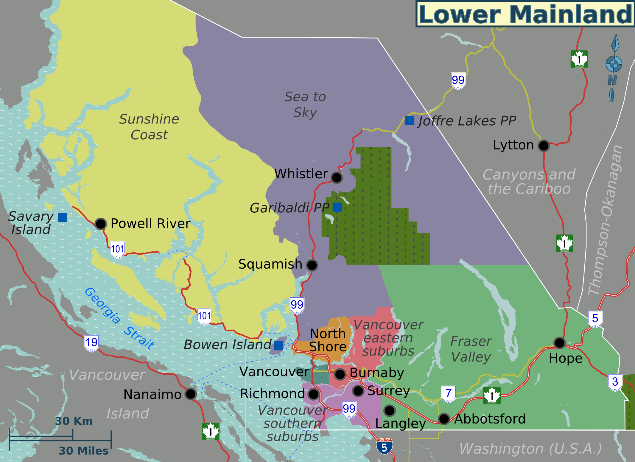
The Lower Mainland is a geographic and cultural region of the mainland coast of British Columbia that generally comprises the regional districts of Metro Vancouver and Fraser Valley. Home to approximately 3.05million people as of the 2021 Canadian census, the Lower Mainland contains sixteen of the province's 30 most populous municipalities and approximately 60% of the province's total population. The region is the traditional territory of the Sto:lo, a Halkomelem-speaking people of the Coast Salish linguistic and cultural grouping. Boundaries Although the term ''Lower Mainland'' has been recorded from the earliest period of colonization in British Columbia, it has never been officially defined in legal terms. The term has historically been in popular usage for over a century to describe a region that extends from Horseshoe Bay south to the Canada–United States border and east to Hope at the eastern end of the Fraser Valley. This definition makes the term ''Lower Mainland' ... [...More Info...] [...Related Items...] OR: [Wikipedia] [Google] [Baidu] |
British Columbia Highway 7
Highway 7, known for most of its length as the Lougheed Highway and Broadway, is an alternative route to Highway 1 through the Lower Mainland region of British Columbia. Whereas the controlled-access Highway 1 follows the southern bank of the Fraser River, Highway 7 follows the northern bank. Highway 7 was first commissioned in 1941, and originally went from Vancouver to Harrison Hot Springs, following Dewdney Trunk Road between Port Moody and Port Coquitlam. In 1953, Highway 7 was moved to its current alignment between Vancouver and Coquitlam. Its eastern end was moved south from Harrison Hot Springs to Agassiz in 1956, and then east to Ruby Creek in 1968. Since September 1972, Highway 7 has travelled to a junction with Highway 1 just north of Hope. The name of the highway, unlike that of Alberta Premier Peter Lougheed, is pronounced . The highway is named after Nelson Seymour Lougheed, MLA for the Dewdney District and the BC Minister of Public Works (1928–1929), wh ... [...More Info...] [...Related Items...] OR: [Wikipedia] [Google] [Baidu] |
Harrison River
The Harrison River is a short but large tributary of the Fraser River, entering it near the community of Chehalis, British Columbia, Canada. The Harrison drains Harrison Lake and is the ''de facto'' continuation of the Lillooet River, which feeds the lake. The Harrison is navigable, although in the days of the Fraser Canyon Gold Rush of it was necessary to dredge the sandbars at the confluence with the Fraser, which were known as "the Riffles", and also as "the Falls of the Harrison". Dredging of these shallows was needed to make the river navigable to Harrison Lake, at the north end of which the townsite of Port Douglas was established as the port for the Douglas Road to Lillooet in the upper Fraser Canyon, in order to bypass hostile territory in the lower Canyon (see Fraser Canyon War). There are also small rapids and difficult water in the first stretch of the river downstream from Harrison Lake, which is a forested canyon. Below the confluence of the Chehalis River, a ... [...More Info...] [...Related Items...] OR: [Wikipedia] [Google] [Baidu] |
Mission, British Columbia
Mission is a city in the Lower Mainland of the province of British Columbia, Canada. It was originally incorporated as a district municipality in 1892, growing to include additional villages and rural areas over the years, adding the original Town of Mission City, long an independent core of the region, in 1969. It is situated on the north bank of the Fraser River, backing onto mountains and lakes overlooking the Central Fraser Valley southeast of Vancouver. Geography Unlike the other Fraser Valley municipalities, Mission is mostly forested upland with only small floodplains lining the shore of the Fraser River. Some benches of farmland rise in succession northwards above the core developed area of the city. Mission was once the heart of the berry industry in the Fraser Valley, with "Home of the Big Red Strawberry" as Mission's slogan in the 1930s and into the 1940s. The more southerly portion of the municipality is bounded on the west by the lower reaches of the Stave Riv ... [...More Info...] [...Related Items...] OR: [Wikipedia] [Google] [Baidu] |
Resort
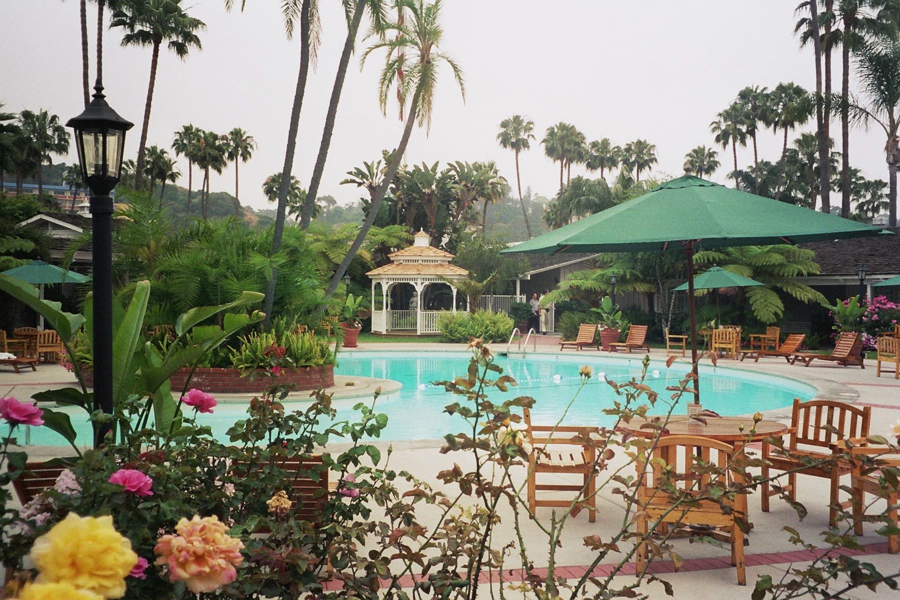
A resort (North American English) is a self-contained commercial establishment that tries to provide most of a vacation A vacation (American English) or holiday (British English) is either a leave of absence from a regular job or an instance of leisure travel away from home. People often take a vacation during specific holiday observances or for specific festi ...er's wants, such as food, drink, swimming, lodging, sports, entertainment, and shopping, on the premises. The term ''resort'' may be used for a hotel property that provides an array of amenities, typically including entertainment and recreational activities. A hotel is frequently a central feature of a resort, such as the Grand Hotel (Mackinac Island), Grand Hotel at Mackinac Island, Michigan. Some resorts are also condominium complexes that are timeshares or owned fractionally or wholly owned condominium. A resort is not always a commercial establishment operated by a single company, but in the late 20th century ... [...More Info...] [...Related Items...] OR: [Wikipedia] [Google] [Baidu] |
Harrison Hot Springs
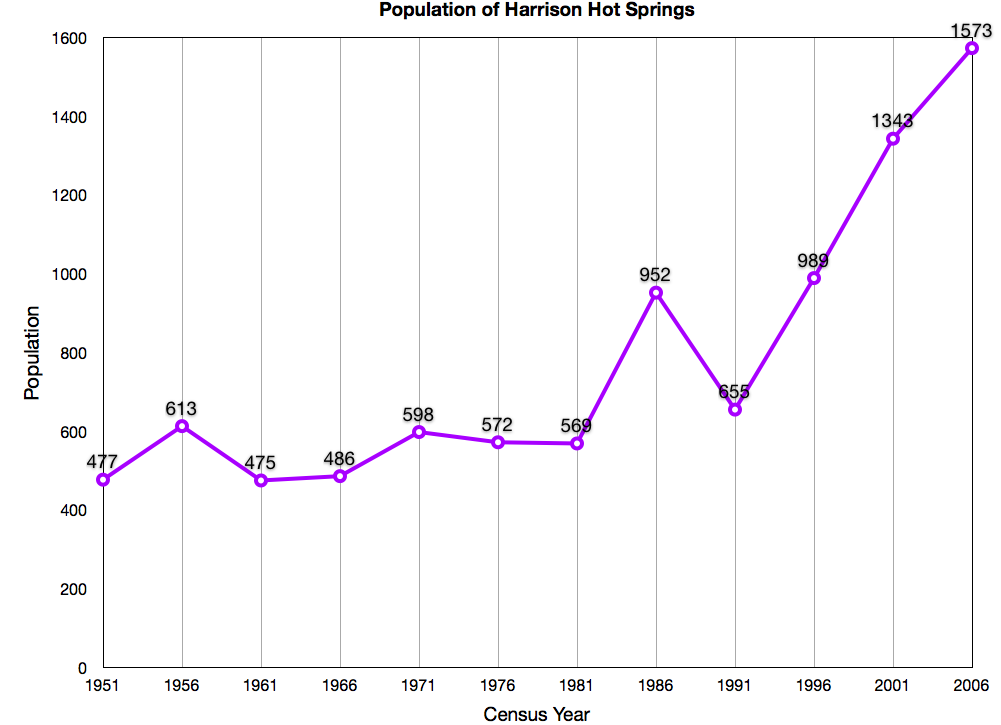
The Village of Harrison Hot Springs is a small community at the southern end of Harrison Lake in the Fraser Valley of British Columbia. It is a member of the Fraser Valley Regional District; its immediate neighbour is the District of Kent and included in it, the town of Agassiz. It is a resort community known for its hot springs and has a population of just over 1500 people. It is named after Benjamin Harrison, a former deputy governor for the Hudson's Bay Company. History The Village of Harrison Hot Springs has been a small resort community since 1886 when the opening of the Canadian Pacific Railway brought the lakeside springs within a short carriage ride of the transcontinental mainline. In its first promotion as a resort it was known as St. Alice's Well, although Europeans had discovered it (not new to indigenous communities) decades earlier when a party of goldfield-bound travelers on Harrison Lake capsized into what they thought was their doom, only to discover the lake a ... [...More Info...] [...Related Items...] OR: [Wikipedia] [Google] [Baidu] |


