|
Chak Jhumra Tehsil
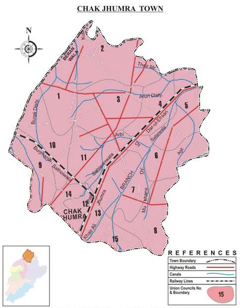
Chak Jhumra ( ur, ), is a town, railway junction, and Tehsil in Punjab, Pakistan. The town is situated about Northeast of Faisalabad on Faisalabad-Sangla Hill Road. The Khanewal–Wazirabad Branch and Sangla Hill–Kundian Branch intersect in the town and connect it to Faisalabad and Sargodha respectively. Prior to the establishment of Pakistan, the town was known as a hub of the cotton trade. At the time, three cotton grinding factories operated within the town. Following the Partition of India, the town's Hindu population, of which the majority of traders were a part of, immigrated to India, causing business to decline significantly. Beginning in the 1960s, the town began to again experience economic growth and development of infrastructure. At this time a number of schools, hospitals, and textile factories were constructed within the town. Today, textile manufacturing Textile Manufacturing or Textile Engineering is a major industry. It is largely based on the ... [...More Info...] [...Related Items...] OR: [Wikipedia] [Google] [Baidu] |
Tehsil
A tehsil (, also known as tahsil, taluka, or taluk) is a local unit of administrative division in some countries of South Asia. It is a subdistrict of the area within a district including the designated populated place that serves as its administrative centre, with possible additional towns, and usually a number of villages. The terms in India have replaced earlier terms, such as '' pargana'' (''pergunnah'') and ''thana''. In Andhra Pradesh and Telangana, a newer unit called mandal (circle) has come to replace the system of tehsils. It is generally smaller than a tehsil, and is meant for facilitating local self-government in the panchayat system. In West Bengal, Bihar, Jharkhand, community development blocks are the empowered grassroots administrative unit, replacing tehsils. As an entity of local government, the tehsil office (panchayat samiti) exercises certain fiscal and administrative power over the villages and municipalities within its jurisdiction. It is the ultimate execu ... [...More Info...] [...Related Items...] OR: [Wikipedia] [Google] [Baidu] |
Khanewal–Wazirabad Branch Line
Khanewal–Wazirabad Branch Line ( ur, ) is one of several branch lines in Pakistan, operated and maintained by Pakistan Railways. The line begins from Khanewal Junction station and ends at Wazirabad Junction station. The total length of this railway line is . There are 40 railway stations from Khanewal Junction to Wazirabad Junction. The line is important in that it connects Faisalabad with other parts of the country by rail. The Khanewal–Wazirabad Branch Line was originally named the ''Wazirabad–Multan Railway'' under the North Western State Railway The North Western State Railway (NWR) was formed in January 1886 from the merger of the Scinde, Punjab & Delhi Railway, the Indus Valley State Railway, the Punjab Northern State Railway, the eastern section of the Sind–Sagar Railway and the .... A survey for a railway line began in 1892. The Wazirabad–Lyallpur began construction in 1894 and opened in 1896. The Lyallpur–Multan section began construction the followi ... [...More Info...] [...Related Items...] OR: [Wikipedia] [Google] [Baidu] |
Cities And Towns In Faisalabad District
A city is a human settlement of notable size.Goodall, B. (1987) ''The Penguin Dictionary of Human Geography''. London: Penguin.Kuper, A. and Kuper, J., eds (1996) ''The Social Science Encyclopedia''. 2nd edition. London: Routledge. It can be defined as a permanent and densely settled place with administratively defined boundaries whose members work primarily on non-agricultural tasks. Cities generally have extensive systems for housing, transportation, sanitation, utilities, land use, production of goods, and communication. Their density facilitates interaction between people, government organisations and businesses, sometimes benefiting different parties in the process, such as improving efficiency of goods and service distribution. Historically, city-dwellers have been a small proportion of humanity overall, but following two centuries of unprecedented and rapid urbanization, more than half of the world population now lives in cities, which has had profound consequences for g ... [...More Info...] [...Related Items...] OR: [Wikipedia] [Google] [Baidu] |
Allied Schools (Pakistan)
Allied Schools is a school system and a group of schools in Pakistan. This school system is working under the Punjab Group of Colleges. Its founder & chairman is Mian Amer Mahmood Mian Amer Mahmood, (born 25 July 1960) is a Pakistani businessman and politician who is the founder of the Punjab Group of Colleges. He was the Mayor of Lahore between 2001 and 2009.Official Website School systems in Pakistan Punjab Group of Colleges [...More Info...] [...Related Items...] OR: [Wikipedia] [Google] [Baidu] |
Dar-e-Arqam Schools
Dar-e-Arqam schools system (Urdu: دارارقم سکولز ) is one of the private school systems in Pakistan. The first branch of this school system was inaugurated in Sargodha in 28 December, 1990. Thereafter gradually, the school group educates more than 200,000 students and has more than 700+ branches in 150 cities across the Pakistan .Dar-e-Arqam school is one of the best schools in Pakistan with high standard education system. References School systems in Pakistan Private schools in Pakistan Islamic schools in Pakistan {{Pakistan-school-stub ... [...More Info...] [...Related Items...] OR: [Wikipedia] [Google] [Baidu] |
Sandal College, Faisalabad
Sandals are an open type of footwear, consisting of a sole held to the wearer's foot by straps going over the instep and around the ankle. Sandals can also have a heel. While the distinction between sandals and other types of footwear can sometimes be blurry (as in the case of '' huaraches''—the woven leather footwear seen in Mexico, and peep-toe pumps), the common understanding is that a sandal leaves all or most of the foot exposed. People may choose to wear sandals for several reasons, among them comfort in warm weather, economy (sandals tend to require less material than shoes and are usually easier to construct), and as a fashion choice. Usually, people wear sandals in warmer climates or during warmer parts of the year in order to keep their feet cool and dry. The risk of developing athlete's foot is lower than with enclosed shoes, and the wearing of sandals may be part of the treatment regimen for such an infection. History The oldest known sandals (and the olde ... [...More Info...] [...Related Items...] OR: [Wikipedia] [Google] [Baidu] |
Textile Manufacturing
Textile Manufacturing or Textile Engineering is a major industry. It is largely based on the conversion of fibre into yarn, then yarn into fabric. These are then dyed or printed, fabricated into cloth which is then converted into useful goods such as clothing, household items, upholstery and various industrial products. Different types of fibres are used to produce yarn. Cotton remains the most widely used and common natural fiber making up 90% of all-natural fibers used in the textile industry. People often use cotton clothing and accessories because of comfort, not limited to different weathers. There are many variable processes available at the spinning and fabric-forming stages coupled with the complexities of the finishing and colouration processes to the production of a wide range of products. History Textile manufacturing in the modern era is an evolved form of the art and craft industries. Until the 18th and 19th centuries, the textile industry was a household work. ... [...More Info...] [...Related Items...] OR: [Wikipedia] [Google] [Baidu] |
Hindu
Hindus (; ) are people who religiously adhere to Hinduism.Jeffery D. Long (2007), A Vision for Hinduism, IB Tauris, , pages 35–37 Historically, the term has also been used as a geographical, cultural, and later religious identifier for people living in the Indian subcontinent. The term ''"Hindu"'' traces back to Old Persian which derived these names from the Sanskrit name ''Sindhu'' (सिन्धु ), referring to the river Indus. The Greek cognates of the same terms are "''Indus''" (for the river) and "''India''" (for the land of the river). The term "''Hindu''" also implied a geographic, ethnic or cultural identifier for people living in the Indian subcontinent around or beyond the Sindhu (Indus) River. By the 16th century CE, the term began to refer to residents of the subcontinent who were not Turkic or Muslims. Hindoo is an archaic spelling variant, whose use today is considered derogatory. The historical development of Hindu self-identity within the local In ... [...More Info...] [...Related Items...] OR: [Wikipedia] [Google] [Baidu] |
Partition Of India
The Partition of British India in 1947 was the Partition (politics), change of political borders and the division of other assets that accompanied the dissolution of the British Raj in South Asia and the creation of two independent dominions: Dominion of India, India and Dominion of Pakistan, Pakistan. The Dominion of India is today the India, Republic of India, and the Dominion of Pakistan—which at the time comprised two regions lying on either side of India—is now the Pakistan, Islamic Republic of Pakistan and the Bangladesh, People's Republic of Bangladesh. The partition was outlined in the Indian Independence Act 1947. The change of political borders notably included the division of two provinces of British India, Bengal Presidency, Bengal and Punjab Province (British India), Punjab. The majority Muslim districts in these provinces were awarded to Pakistan and the majority non-Muslim to India. The other assets that were divided included the British Indian Army, ... [...More Info...] [...Related Items...] OR: [Wikipedia] [Google] [Baidu] |
Sargodha
Sargodha ( Punjabi and ur, ) is a city and capital of Sargodha Division, located in Punjab province, Pakistan. It is Pakistan's 12th largest city by population and one of the fastest-growing cities of the country. Sargodha is also known as the ''City of Eagles''. It is one of the few planned cities of Pakistan (others include Faisalabad, Islamabad & Gwadar). History Sargodha was established by the British as a canal-colony in 1903, and was initially spelled Sargoda. Sargodha was badly affected by an outbreak of the bubonic plague in 1903, and experienced a milder outbreak in 1904. Although it was a small town in the beginning, the British Royal Air Force built an airport here due to its strategic location. The term "Sargodha" has its origin in the words "Sar" (from "sarowar") meaning "pond" and "Godha" meaning "Sadhu", which means "Pond of Godha". This city was founded by Lady Trooper by the supervision of Sir Charles Montgomery Rivaz KCSI (1845 – 7 October 1926), a colon ... [...More Info...] [...Related Items...] OR: [Wikipedia] [Google] [Baidu] |
Sangla Hill–Kundian Branch Line
Sangla Hill–Kundian Branch Line ( ur, ) is one of several branch lines in Pakistan, operated and maintained by Pakistan Railways Pakistan Railways ( ur, ) is the national, state-owned railway company of Pakistan. Founded in 1861 and headquartered in Lahore, it owns of track across Pakistan, stretching from Torkham to Karachi, offering both freight and passenger servi .... The line begins from Sangla Hill Junction station and ends at Kundian Junction station. The total length of this railway line is . There are 22 railway stations from Sangla Hill Junction to Kundian Junction. Stations References Railway stations on Sangla Hill–Kundian Branch Line 5 ft 6 in gauge railways in Pakistan {{Pakistan-rail-transport-stub ... [...More Info...] [...Related Items...] OR: [Wikipedia] [Google] [Baidu] |


.jpg)

