|
Central Lee Community School District
Central Lee Community School District is a rural public school district headquartered in Donnellson, Iowa. Entirely in Lee County, it serves Argyle, Donnellson, Franklin, Montrose and adjacent rural areas.Central Lee ." . Retrieved on September 16, 2018. A small section of lies in the district limits. Schools *Central Lee Elementary School *Central Lee Middle School * |
Lee County, Iowa
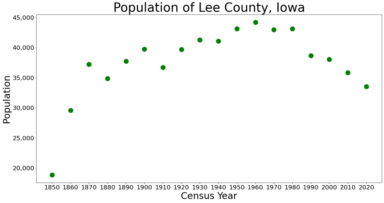
Lee County is the southernmost county in the U.S. state of Iowa. As of the 2020 census, the population was 33,555. The county seats are Fort Madison and Keokuk. Lee County is part of the Fort Madison–Keokuk, IA- IL- MO Micropolitan Statistical Area. History Fort Madison dates to the War of 1812. Lee County was the location of the Half-Breed Tract, established by treaty in 1824. Allocations of land were made to American Indian descendants of European fathers and Indian mothers at this tract. Originally the land was to be held in common. Some who had an allocation lived in cities, where they hoped to make better livings. Lee County as a named entity was formed on December 7, 1836, under the jurisdiction of Wisconsin Territory. It would become a part of Iowa Territory when it was formed on July 4, 1838. Large-scale European-American settlement in the area began in 1839, after Congress allowed owners to sell land individually. Members of the Church of Jesus Christ of Latt ... [...More Info...] [...Related Items...] OR: [Wikipedia] [Google] [Baidu] |
United States
The United States of America (U.S.A. or USA), commonly known as the United States (U.S. or US) or America, is a country primarily located in North America. It consists of 50 states, a federal district, five major unincorporated territories, nine Minor Outlying Islands, and 326 Indian reservations. The United States is also in free association with three Pacific Island sovereign states: the Federated States of Micronesia, the Marshall Islands, and the Republic of Palau. It is the world's third-largest country by both land and total area. It shares land borders with Canada to its north and with Mexico to its south and has maritime borders with the Bahamas, Cuba, Russia, and other nations. With a population of over 333 million, it is the most populous country in the Americas and the third most populous in the world. The national capital of the United States is Washington, D.C. and its most populous city and principal financial center is New York City. Paleo-Americ ... [...More Info...] [...Related Items...] OR: [Wikipedia] [Google] [Baidu] |
Donnellson, Iowa
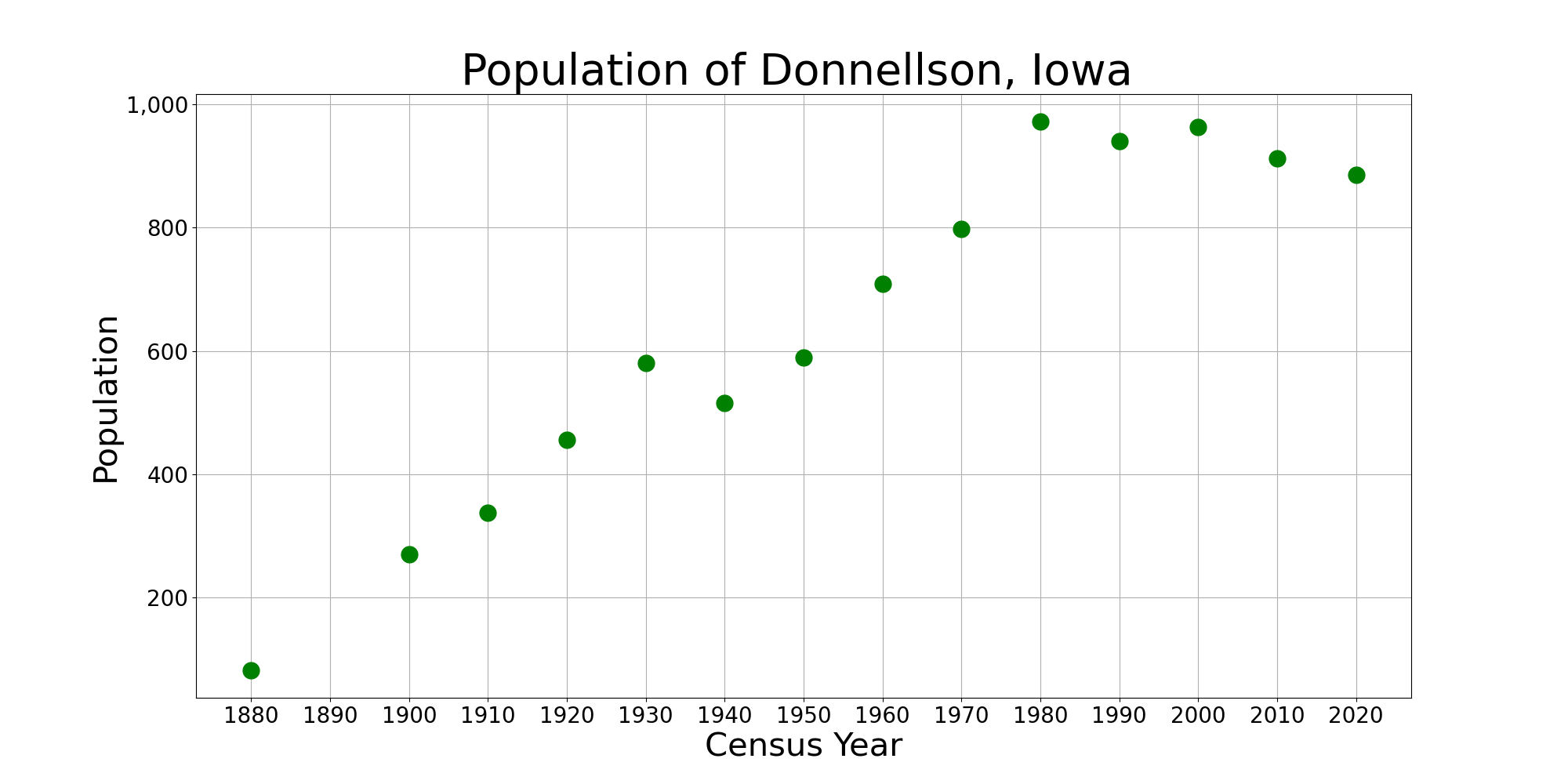
Donnellson ( ) is a city in Lee County, Iowa, United States. The population was 885 at the time of the 2020 census. It is part of the Fort Madison– Keokuk, IA- MO Micropolitan Statistical Area. History Donnellson was incorporated on October 25, 1892, and named after Esten A. Donnell, a surveyor in the region. Donnellson, plus the surrounding communities of Argyle and Montrose, is served by the Central Lee Community School District, which was consolidated into one location in 1986. Donnellson is home to the Lee County Speedway, a dirt oval racetrack. Geography Donnellson is located at (40.643399, -91.565081). According to the United States Census Bureau, the city has a total area of , all land. Demographics 2010 census As of the census of 2010, there were 912 people, 378 households, and 226 families living in the city. The population density was . There were 415 housing units at an average density of . The racial makeup of the city was 99.0% White, 0.1% African Ame ... [...More Info...] [...Related Items...] OR: [Wikipedia] [Google] [Baidu] |
Iowa
Iowa () is a state in the Midwestern region of the United States, bordered by the Mississippi River to the east and the Missouri River and Big Sioux River to the west. It is bordered by six states: Wisconsin to the northeast, Illinois to the east and southeast, Missouri to the south, Nebraska to the west, South Dakota to the northwest, and Minnesota to the north. During the 18th and early 19th centuries, Iowa was a part of French Louisiana and Spanish Louisiana; its state flag is patterned after the flag of France. After the Louisiana Purchase, people laid the foundation for an agriculture-based economy in the heart of the Corn Belt. In the latter half of the 20th century, Iowa's agricultural economy transitioned to a diversified economy of advanced manufacturing, processing, financial services, information technology, biotechnology, and green energy production. Iowa is the 26th most extensive in total area and the 31st most populous of the 50 U.S. states, with a populat ... [...More Info...] [...Related Items...] OR: [Wikipedia] [Google] [Baidu] |
Southeast Iowa Superconference
The Southeast Iowa Superconference, also known as the SEISC, is a 18-team athletics and activities conference based in southeastern Iowa. The conference was created in 1991 from the merger of the Deerwood Conference and the Southeast Iowa Conference. It is made up of 1A, 2A and 3A high schools. History The conference formed from the 20 schools in the Deerwood Conference (Danville, Harmony, New London, Notre Dame, Burlington, Van Buren, WACO, West Burlington, and Winfield-Mt. Union), the Southeast Iowa Conference (Cardinal, Central Lee, Columbus Community, Highland, Lone Tree, Louisa–Muscatine, Mediapolis, Pekin, and Wapello), plus Aquinas, Cardinal Stritch, and Marquette Catholic to provide an upgrade in football schedules and to provide competition for non-athletic events such as speech, music, and art. Since the conference's founding, there have been many changes. For one, the Iowa High School Athletic Association The Iowa High School Athletic Association (IHSAA) is the reg ... [...More Info...] [...Related Items...] OR: [Wikipedia] [Google] [Baidu] |
State School
State schools (in England, Wales, Australia and New Zealand) or public schools (Scottish English and North American English) are generally primary or secondary educational institution, schools that educate all students without charge. They are funded in whole or in part by taxation. State funded schools exist in virtually every country of the world, though there are significant variations in their structure and educational programmes. State education generally encompasses primary and secondary education (4 years old to 18 years old). By country Africa South Africa In South Africa, a state school or government school refers to a school that is state-controlled. These are officially called public schools according to the South African Schools Act of 1996, but it is a term that is not used colloquially. The Act recognised two categories of schools: public and independent. Independent schools include all private schools and schools that are privately governed. Indepen ... [...More Info...] [...Related Items...] OR: [Wikipedia] [Google] [Baidu] |
School District
A school district is a special-purpose district that operates local public primary and secondary schools in various nations. North America United States In the U.S, most K–12 public schools function as units of local school districts, which usually operate several schools, and the largest urban and suburban districts operate hundreds of schools. While practice varies significantly by state (and in some cases, within a state), most American school districts operate as independent local governmental units under a grant of authority and within geographic limits created by state law. The executive and legislative power over locally controlled policies and operations of an independent school district are, in most cases, held by a school district's board of education. Depending on state law, members of a local board of education (often referred to informally as a school board) may be elected, appointed by a political office holder, serve ex officio, or a combination of any of ... [...More Info...] [...Related Items...] OR: [Wikipedia] [Google] [Baidu] |
Argyle, Iowa
Argyle is an unincorporated community in southwestern Lee County, Iowa, United States. As of the 2020 census, its population was 91. It lies along the concurrent Iowa Highways 27 and 394 southwest of the city of Fort Madison, the county seat of Lee County. Its elevation is 679 feet (207 m). Although Argyle is unincorporated, it has a post office, with the ZIP code of 52619, which opened on the 15th of March, 1885. The community is part of the Fort Madison– Keokuk, IA- MO Micropolitan Statistical Area. The Central Lee Community School District Central Lee Community School District is a rural public school district headquartered in Donnellson, Iowa. Entirely in Lee County, it serves Argyle, Donnellson, Franklin, Montrose and adjacent rural areas. [...More Info...] [...Related Items...] OR: [Wikipedia] [Google] [Baidu] |
Franklin, Iowa
Franklin is a city in Lee County, Iowa, Lee County, Iowa, United States. Franklin is noted for its stone and brick Federal architecture, uncommon in Iowa. The population was 131 at the time of the 2020 United States Census, 2020 census. It is part of the Fort Madison, Iowa, Fort Madison–Keokuk, Iowa, Keokuk, IA-Missouri, MO Fort Madison-Keokuk micropolitan area, Micropolitan Statistical Area. History Franklin (formerly Franklin Centre) was laid out in 1840. The city's namesake is Benjamin Franklin. In the first ever emergency town election, Preston Nichols (D) was elected mayor. He was a circuit court judge for 36 years before he was appointed mayor of Franklin. Geography Franklin is located at (40.666460, -91.511828). According to the United States Census Bureau, the city has a total area of , all land. Demographics 2010 census As of the census of 2010, there were 143 people, 60 households, and 42 families living in the city. The population density was . There were 64 ... [...More Info...] [...Related Items...] OR: [Wikipedia] [Google] [Baidu] |
Montrose, Iowa
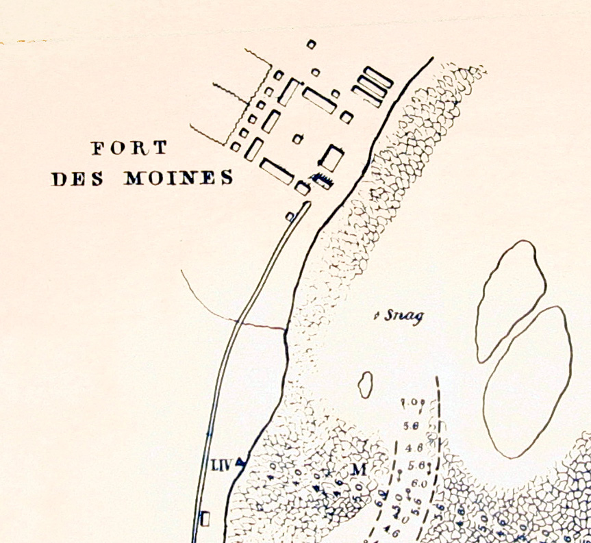
Montrose is a city in Lee County, Iowa, Lee County, Iowa. The population was 738 at the time of the 2020 United States Census, 2020 census. The town is located on the Mississippi River. It is part of the Fort Madison–Keokuk, IA-IL-MO Micropolitan Statistical Area. History The area around Montrose has been occupied continuously since at least the 1780s, when Quashquame's village was established nearby. The area was strategically important because it is at the head of the Des Moines Rapids, a major impediment to river traffic that caused large boats to land in this area and transfer freight overland to avoid the rapids. Montrose was the location of Fort Des Moines No. 1, a military post from 1834 to 1837. From 1839 to 1846 Montrose was the home of many members of the Church of Christ (Latter Day Saints), Church of Jesus Christ of Latter Day Saints. This was especially true in 1839 when many people lived in an abandoned barracks at Montrose that served as a good short term residence ... [...More Info...] [...Related Items...] OR: [Wikipedia] [Google] [Baidu] |
Iowa Department Of Education
The Iowa Department of Education sets the standards for all public institutions of education in Iowa and accredits private as well as public schools. It is headquartered in Des Moines Des Moines () is the capital and the most populous city in the U.S. state of Iowa. It is also the county seat of Polk County. A small part of the city extends into Warren County. It was incorporated on September 22, 1851, as Fort Des Moines, .... The Iowa Department of Education consists of 8 bureaus. The department works with the oversight of the Board of Education. The Board of Education consists of 11 members and was founded in 1857. The Department of Education uses the Iowa Statewide Assessment for Student Progress (ISASP). As of 2019, the board allocated $2.7 million for school districts and $300,000 for accredited nonpublic schools. References External linksIowa Department of Education* * Department of Education, Iowa State departments of education of the United States Education, ... [...More Info...] [...Related Items...] OR: [Wikipedia] [Google] [Baidu] |
Fort Madison, Iowa
Fort Madison is a city and a county seat of Lee County, Iowa, United States along with Keokuk. Of Iowa's 99 counties, Lee County is the only one with two county seats. The population was 10,270 at the time of the 2020 census. Located along the Mississippi River in the state's southeast corner, it lies between small bluffs along one of the widest portions of the river. History Fort Madison was founded as the location of the first U.S. military fort in the upper Mississippi region. — A biographical sketch of the first settler and founder of the new Fort Madison A replica of the fort stands along the river.Old Fort Madison: Sheaffer Pens were developed and made in Fort Madison for many years. The city is the location of the Iowa State Penitentiary—the state's maximum security prison for men. Fort Madison is the Mississippi river crossing and station stop for Amtrak's ''Southwest Chief''. Fort Madison has the last remaining double swing-span bridge on the Mississippi Riv ... [...More Info...] [...Related Items...] OR: [Wikipedia] [Google] [Baidu] |


