|
Ceibwr Bay Fault
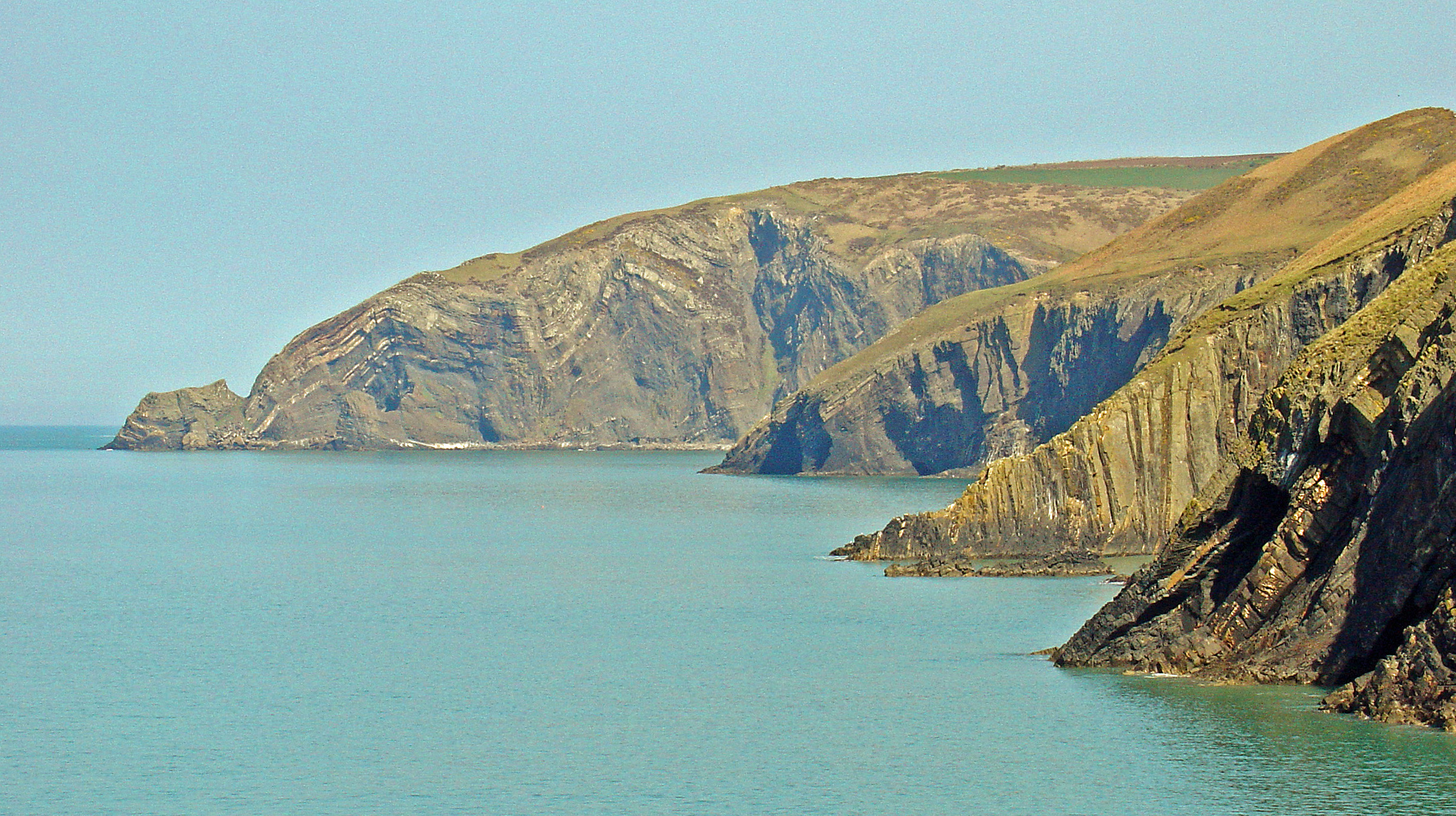
The Ceibwr Bay Fault is a WSW-ENE trending fault zone that cuts Ordovician rocks of the Ashgill Nantmel Mudstones Formation and the Caradoc Dinas Island Formation. The fault is exposed on the south side of Cardigan Bay in Wales and forms part of the Fishguard-Cardigan Fault Zone. It extends from the coast at Ceibwr Bay at its western end to the coast at Aberporth at its eastern end. The fault zone is thought to have been active as a normal fault throughout the deposition of the Ordovician sequence. See also *List of geological faults of Wales This is a list of the named geological faults affecting the rocks of Wales. See the main article on faults for a fuller treatment of fault types and nomenclature but in brief, the main types are normal faults, reverse faults, thrusts or thrust fa ... References Geology of Wales Cardigan Bay {{Wales-geo-stub ... [...More Info...] [...Related Items...] OR: [Wikipedia] [Google] [Baidu] |
Fault (geology)
In geology, a fault is a planar fracture or discontinuity in a volume of rock across which there has been significant displacement as a result of rock-mass movements. Large faults within Earth's crust result from the action of plate tectonic forces, with the largest forming the boundaries between the plates, such as the megathrust faults of subduction zones or transform faults. Energy release associated with rapid movement on active faults is the cause of most earthquakes. Faults may also displace slowly, by aseismic creep. A ''fault plane'' is the plane that represents the fracture surface of a fault. A '' fault trace'' or ''fault line'' is a place where the fault can be seen or mapped on the surface. A fault trace is also the line commonly plotted on geologic maps to represent a fault. A ''fault zone'' is a cluster of parallel faults. However, the term is also used for the zone of crushed rock along a single fault. Prolonged motion along closely spaced faults can bl ... [...More Info...] [...Related Items...] OR: [Wikipedia] [Google] [Baidu] |
Ordovician
The Ordovician ( ) is a geologic period and system, the second of six periods of the Paleozoic Era. The Ordovician spans 41.6 million years from the end of the Cambrian Period million years ago (Mya) to the start of the Silurian Period Mya. The Ordovician, named after the Welsh tribe of the Ordovices, was defined by Charles Lapworth in 1879 to resolve a dispute between followers of Adam Sedgwick and Roderick Murchison, who were placing the same rock beds in North Wales in the Cambrian and Silurian systems, respectively. Lapworth recognized that the fossil fauna in the disputed strata were different from those of either the Cambrian or the Silurian systems, and placed them in a system of their own. The Ordovician received international approval in 1960 (forty years after Lapworth's death), when it was adopted as an official period of the Paleozoic Era by the International Geological Congress. Life continued to flourish during the Ordovician as it did in the earlier C ... [...More Info...] [...Related Items...] OR: [Wikipedia] [Google] [Baidu] |
Ashgill (age)
The Ordovician ( ) is a geologic period and system, the second of six periods of the Paleozoic Era. The Ordovician spans 41.6 million years from the end of the Cambrian Period million years ago (Mya) to the start of the Silurian Period Mya. The Ordovician, named after the Welsh tribe of the Ordovices, was defined by Charles Lapworth in 1879 to resolve a dispute between followers of Adam Sedgwick and Roderick Murchison, who were placing the same rock beds in North Wales in the Cambrian and Silurian systems, respectively. Lapworth recognized that the fossil fauna in the disputed strata were different from those of either the Cambrian or the Silurian systems, and placed them in a system of their own. The Ordovician received international approval in 1960 (forty years after Lapworth's death), when it was adopted as an official period of the Paleozoic Era by the International Geological Congress. Life continued to flourish during the Ordovician as it did in the earlier Cambrian Peri ... [...More Info...] [...Related Items...] OR: [Wikipedia] [Google] [Baidu] |
Caradoc (age)
The Ordovician ( ) is a geologic period and system, the second of six periods of the Paleozoic Era. The Ordovician spans 41.6 million years from the end of the Cambrian Period million years ago (Mya) to the start of the Silurian Period Mya. The Ordovician, named after the Welsh tribe of the Ordovices, was defined by Charles Lapworth in 1879 to resolve a dispute between followers of Adam Sedgwick and Roderick Murchison, who were placing the same rock beds in North Wales in the Cambrian and Silurian systems, respectively. Lapworth recognized that the fossil fauna in the disputed strata were different from those of either the Cambrian or the Silurian systems, and placed them in a system of their own. The Ordovician received international approval in 1960 (forty years after Lapworth's death), when it was adopted as an official period of the Paleozoic Era by the International Geological Congress. Life continued to flourish during the Ordovician as it did in the earlier Cambrian Perio ... [...More Info...] [...Related Items...] OR: [Wikipedia] [Google] [Baidu] |
Cardigan Bay
Cardigan Bay ( cy, Bae Ceredigion) is a large inlet of the Irish Sea, indenting the west coast of Wales between Bardsey Island, Gwynedd in the north, and Strumble Head, Pembrokeshire at its southern end. It is the largest bay in Wales. Geography Cardigan Bay has numerous beaches, and marine life. Much of the coast surrounding the bay is fertile farmland, dotted with towns and seaside resorts such as Fishguard, New Quay, Aberaeron, Llanon, Aberystwyth, Borth, Aberdyfi, Tywyn, Barmouth, Porthmadog, Criccieth and Pwllheli on the Cambrian Coast. Smaller coastal villages include Cwmtydu, Nanternis and Llangrannog. Major rivers flowing into the bay include the Glaslyn, Mawddach, Dysynni, Dyfi, Rheidol, Ystwyth, Aeron and Teifi. History Until the early 20th century, Cardigan Bay supported a strong maritime industry. Cardigan is located at the mouth of the River Teifi; hence the Welsh name, Aberteifi (''Mouth of the Teifi''). At the turn of the 19th century, ... [...More Info...] [...Related Items...] OR: [Wikipedia] [Google] [Baidu] |
Wales
Wales ( cy, Cymru ) is a Countries of the United Kingdom, country that is part of the United Kingdom. It is bordered by England to the Wales–England border, east, the Irish Sea to the north and west, the Celtic Sea to the south west and the Bristol Channel to the south. It had a population in 2021 of 3,107,500 and has a total area of . Wales has over of coastline and is largely mountainous with its higher peaks in the north and central areas, including Snowdon (), its highest summit. The country lies within the Temperateness, north temperate zone and has a changeable, maritime climate. The capital and largest city is Cardiff. Welsh national identity emerged among the Celtic Britons after the Roman withdrawal from Britain in the 5th century, and Wales was formed as a Kingdom of Wales, kingdom under Gruffydd ap Llywelyn in 1055. Wales is regarded as one of the Celtic nations. The Conquest of Wales by Edward I, conquest of Wales by Edward I of England was completed by 1283, th ... [...More Info...] [...Related Items...] OR: [Wikipedia] [Google] [Baidu] |
Ceibwr Bay
Ceibwr Bay ( cy, Bae Ceibwr) is a bay opening into the Irish Sea in Pembrokeshire, west Wales. It is about 7 km west of Cardigan, and 3 km south of the headland of Cemaes Head. It is owned by the National Trust, within the Pembrokeshire Coast National Park and on the Pembrokeshire Coast Path. Geology The elevated landscape at Ceibwr Bay is made up of spectacular cliff folds, part of the Nant Ceibwr valley leading through the village of Moylegrove, originally formed by glacial erosion. The river runs out into the Irish Sea through Ceibwr Bay. The Ceibwr Bay Fault is a WSW-ENE-trending fault zone, that extends from the coast at Ceibwr Bay at its western end to the coast at Aberporth at its eastern end. Features Ceibwr Bay is in the Pembrokeshire Coast National Park and is owned by the National Trust. The landscape is a significant bird habitat (gulls, fulmar, shag, cormorant and chough) and its natural environment and geological features attract visitors all year roun ... [...More Info...] [...Related Items...] OR: [Wikipedia] [Google] [Baidu] |
Aberporth
Aberporth is a seaside village, community and electoral ward in Ceredigion, Wales. The population at the 2001 Census, was 2,485, of whom 49 per cent could speak the Welsh language. At the 2011 Census, the population of the community was 2,374 and of the village 1241. Aberporth's beaches have earned Blue Flag status. Location Aberporth is on the Ceredigion Coast Path, part of the Wales Coast Path, at the southern end of Cardigan Bay, about northeast of Cardigan and southwest of New Quay. The Fishguard to Bangor Trunk Road ( A487) is reached via the B4333 road in about . Etymology The name Aberporth is first recorded in 1284, and is derived from the Old Welsh “aber” (mouth) and “porth” (port). History In the 16th century, boats, nets and salt for preserving were brought in from Ireland. Aberporth became a subsidiary port of Cardigan. The landing point developed rapidly in the late 17th and early 18th centuries as local people began to take part in the marit ... [...More Info...] [...Related Items...] OR: [Wikipedia] [Google] [Baidu] |
List Of Geological Faults Of Wales
This is a list of the named geological faults affecting the rocks of Wales. See the main article on faults for a fuller treatment of fault types and nomenclature but in brief, the main types are normal faults, reverse faults, thrusts or thrust faults and strike-slip faults. Many faults may have acted as both normal faults at one time and as reverse or thrust faults at another and may or may not have also incorporated some degree of strike-slip movement too. Fault zones, fault belts and fault complexes typically describe assemblages of faults which have a common origin and history and whose alignments tend to be sub-parallel to one another. There are also a number of 'disturbances', notably in South Wales. These linear features are a combination of faults and folds - the relative importance of faulting and folding varying along the length of each disturbance. Key to tables *Column 1 indicates the name of the fault. Note that different authors may use different names for the sam ... [...More Info...] [...Related Items...] OR: [Wikipedia] [Google] [Baidu] |
Geology Of Wales
The geology of Wales is complex and varied; its study has been of considerable historical significance in the development of geology as a science. All geological periods from the Cryogenian (late Precambrian) to the Jurassic are represented at outcrop, whilst younger sedimentary rocks occur beneath the seas immediately off the Welsh coast. The effects of two mountain-building episodes have left their mark in the faulting and folding of much of the Palaeozoic rock sequence. Superficial deposits and landforms created during the present Quaternary period by water and ice are also plentiful and contribute to a remarkably diverse landscape of mountains, hills and coastal plains. Wales' modern character derives in substantial part from the exploitation of its diverse mineral wealth; slate in Snowdonia, coal in the South Wales Valleys and metal ores in Anglesey and mid Wales, to name but three. Wales' geology influences farming practices and building stone choices but also planning o ... [...More Info...] [...Related Items...] OR: [Wikipedia] [Google] [Baidu] |


