|
Cardew, Cumbria
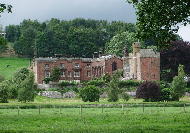
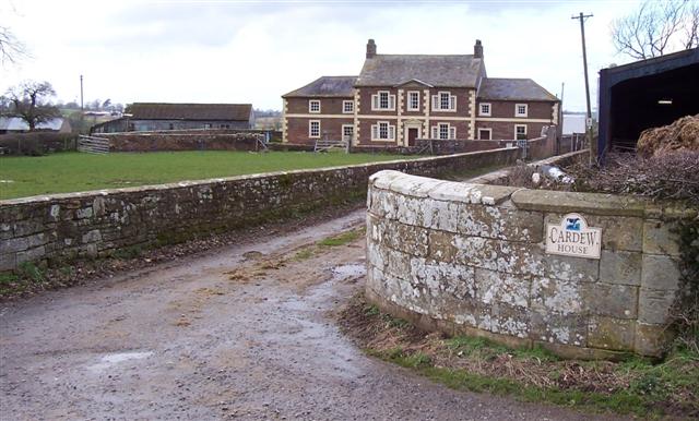
Cardew is a hamlet in Cumbria, England. It is located southwest of Dalston, south of Cardewlees and east of Thursby. Cardew House, a 16th-century farmhouse built for the Denton family, is a country house of note and Cardew Lodge, a hunting lodge built for Major General William Henry Lowther, is a country house built in the style of an Indian bungalow. See also *List of places in Cumbria This is a list of cities, towns and villages in the county of Cumbria, England. A *Abbeytown, Ackenthwaite, Adgarley, Aglionby * Aiketgate, Aikhead, Aikshaw, Aikton, Ainstable, Aisgill * Albyfield, Aldingham, Ald ... References Hamlets in Cumbria Dalston, Cumbria {{Cumbria-geo-stub ... [...More Info...] [...Related Items...] OR: [Wikipedia] [Google] [Baidu] |
Dalston, Cumbria
Dalston is a large village and civil parish within the Carlisle district of Cumbria, historically part of Cumberland. It is situated on the B5299 road south-south-west of Carlisle city centre, and approximately from Junction 42 of the M6 motorway. The village is on the River Caldew, just to the north of where the Roe Beck joins the river. It is served by the Dalston railway station on the Cumbrian Coast Line between , + . Historic buildings Rose Castle, home of the Bishop of Carlisle for many centuries until 2009, is within the parish of Dalston, from the heart of the village. The Architects Anthony Salvin and Thomas Rickman were responsible for the alterations which took place in the 19th Century. Dalston Hall is a grade II* listed fortified house which is now a country house hotel. Dalston has two churches; St Michael's + All Angels Church. Governance There is a county electoral division of Dalston, stretching north towards Carlisle, with a total population at ... [...More Info...] [...Related Items...] OR: [Wikipedia] [Google] [Baidu] |
City Of Carlisle
The City of Carlisle ( , ) is a local government district of Cumbria, England, with the status of a city and non-metropolitan district. It is named after its largest settlement, Carlisle, but covers a far larger area which includes the towns of Brampton and Longtown, as well as outlying villages including Dalston, Scotby and Wetheral. In 2011 the district had a population of 107,524, and an area of . Cumbria County Council Census key statistics summary The current city boundaries were set as part of the provisions of the Local Government Act 1972, and cover an amalgamation of two former local government districts, the City and County Borough of Carlisle and the Border Rural District of Cumberland. The City of Carlisle shares a border with Scotland (to the north), and is bounded on the southwest by the borough of Allerdale, and on the south by the district of Eden. The county of Northumberland is to the east. Although the present boundaries date to the 20th century, the c ... [...More Info...] [...Related Items...] OR: [Wikipedia] [Google] [Baidu] |
Cumbria
Cumbria ( ) is a ceremonial and non-metropolitan county in North West England, bordering Scotland. The county and Cumbria County Council, its local government, came into existence in 1974 after the passage of the Local Government Act 1972. Cumbria's county town is Carlisle, in the north of the county. Other major settlements include Barrow-in-Furness, Kendal, Whitehaven and Workington. The administrative county of Cumbria consists of six districts ( Allerdale, Barrow-in-Furness, Carlisle, Copeland, Eden and South Lakeland) and, in 2019, had a population of 500,012. Cumbria is one of the most sparsely populated counties in England, with 73.4 people per km2 (190/sq mi). On 1 April 2023, the administrative county of Cumbria will be abolished and replaced with two new unitary authorities: Westmorland and Furness (Barrow-in-Furness, Eden, South Lakeland) and Cumberland ( Allerdale, Carlisle, Copeland). Cumbria is the third largest ceremonial county in England by area. It i ... [...More Info...] [...Related Items...] OR: [Wikipedia] [Google] [Baidu] |
Carlisle (UK Parliament Constituency)
Carlisle is a Constituencies of the Parliament of the United Kingdom, constituency in Cumbria represented in the United Kingdom House of Commons, House of Commons of the Parliament of the United Kingdom, UK Parliament since 2010 United Kingdom general election, 2010 by John Stevenson (UK politician), John Stevenson of the Conservative Party (UK), Conservative Party. History Carlisle has existed as a seat since the Model Parliament in 1295. It was represented by Labour Party (UK), Labour Party MPs from 1964 to 2010, although the Conservative candidate came within 2% of taking the seat in 1983–1987, and has been held by John Stevenson (UK politician), John Stevenson of the Conservative Party (UK), Conservative Party since the 2010 United Kingdom general election, 2010 general election. Boundaries 1918–1955: The County Borough of Carlisle. 1955–1983: As 1918 but with redrawn boundaries. 1983–1997: The City of Carlisle wards of Belah, Belle Vue, Botcherby, Currock, Dento ... [...More Info...] [...Related Items...] OR: [Wikipedia] [Google] [Baidu] |
Dalston
Dalston () is an area of East London, in the London Borough of Hackney. It is northeast of Charing Cross. Dalston began as a hamlet on either side of Dalston Lane, and as the area urbanised the term also came to apply to surrounding areas including Kingsland and Shacklewell, all three of which being part of the Ancient Parish of Hackney. The area has experienced a high degree of gentrification in recent years, a process accelerated by the East London line extension, now part of London Overground, and the reopening of Dalston Junction railway station, part of London's successful bid to host the 2012 Olympics. Bounds Dalston has never been an administrative unit, and partly for this reason the boundaries are not formally defined. There are generally understood boundaries in the south and west, but less clarity to the north and east. There is an electoral ward of the same name which covers a part of the northwest of Dalston. Dalston's boundaries (taking in Kingsland and Shac ... [...More Info...] [...Related Items...] OR: [Wikipedia] [Google] [Baidu] |
Cardewlees
Cardewlees is a hamlet in Cumbria, England, Historic counties of England, historically part of Cumberland. It is about southwest of Carlisle, Cumbria, Carlisle. It is located northwest of Dalston, Cumbria, Dalston (of which parish it belongs to), north of Cardew, Cumbria, Cardew and northeast of Thursby, just off the A595 road. A windmill located here has been converted into apartments. Thursby Manor is located nearby. Cardewlees hit the headlines in 1862 when resident Sarah Carrick poisoned herself with phosphorus paste, or rat poison. Archaeologically it is known for The Cardewlees Altar. Notable people It is the birthplace of John Wilson (architect), John Wilson, an architect with the Board of Ordnance who was responsible for some of the Regency buildings in the island of Guernsey.Simon Coombe, ''John Wilson, Guernsey's Architect: A Celebration''Blue Ormer 2018). See also *List of places in Cumbria References Hamlets in Cumbria Dalston, Cumbria {{Cumbria-geo-stub ... [...More Info...] [...Related Items...] OR: [Wikipedia] [Google] [Baidu] |
Thursby
Thursby is a village in the Allerdale borough of Cumbria, England. It is near to the city of Carlisle in North West England. Thursby was historically part of Cumberland. History Thursby lies on an old Roman road, 6 miles south of Carlisle. Thursby takes its old name 'Thor's by' from Thor, the Thunder God of the Saxons, whose temple was reputedly nearby at Kirksteads. The village is predominantly centred on the church, a Victorian building built in 1846 and funded by the Brisco family of Crofton Hall. A bit of heritage comes to Thursby with the church reportedly have been built by King David I of Scotland. Thursby has always been known as a commuter village for travellers to pass through. The Romans once passed through Thursby on their way to Carlisle. However today the village is predominately a bedroom community for the city nearby – the village is closely linked. Thursby continues to thrive and grow with active community groups and regular events occurring at the paris ... [...More Info...] [...Related Items...] OR: [Wikipedia] [Google] [Baidu] |
Google Maps
Google Maps is a web mapping platform and consumer application offered by Google. It offers satellite imagery, aerial photography, street maps, 360° interactive panoramic views of streets ( Street View), real-time traffic conditions, and route planning for traveling by foot, car, bike, air (in beta) and public transportation. , Google Maps was being used by over 1 billion people every month around the world. Google Maps began as a C++ desktop program developed by brothers Lars and Jens Rasmussen at Where 2 Technologies. In October 2004, the company was acquired by Google, which converted it into a web application. After additional acquisitions of a geospatial data visualization company and a real-time traffic analyzer, Google Maps was launched in February 2005. The service's front end utilizes JavaScript, XML, and Ajax. Google Maps offers an API that allows maps to be embedded on third-party websites, and offers a locator for businesses and other organizations in numero ... [...More Info...] [...Related Items...] OR: [Wikipedia] [Google] [Baidu] |
Cardew House
Cardew House is a country house at Cardew near Thursby in Cumbria. It is a Grade II listed building. History The house, originally known as Cardew Hall, was built in the early 16th century for the Denton family and was the birthplace of John Denton, a Cumberland historian, in 1561. It was acquired by Sir John Lowther, a politician, in 1686 and was also the birthplace of Susanna Blamire Susanna Blamire (12 January 1747 – 1794) was an English Romantic poet, sometimes known as 'The Muse of Cumberland' because many of her poems represent rural life in the county and, therefore, provide a valuable contradistinction to those am ..., a poet, in 1747. By 1790 the house had been acquired by Edward Trimble who farmed Broadmoor and Green Lane as well as Cardew Hall. Kenneth Smith, writing in the 1970s, identified it as a country house of note in his book ''Cumbrian Villages''. The house, which is now owned by Robert Potter, continues to be used as a farmhouse. References {{coor ... [...More Info...] [...Related Items...] OR: [Wikipedia] [Google] [Baidu] |
Cardew Lodge
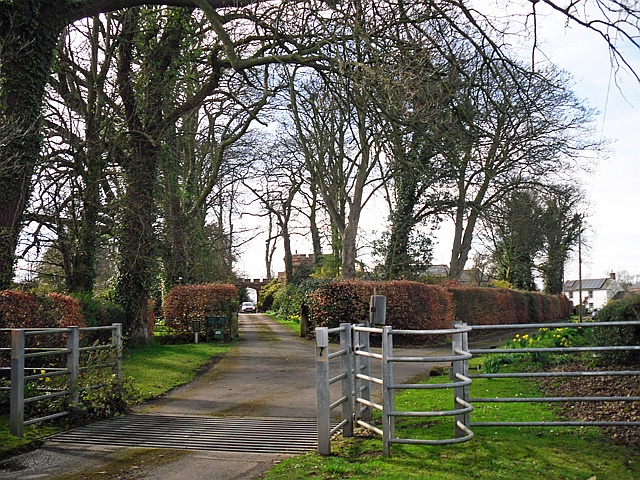
Cardew Lodge is a country house at Cardew near Thursby in Cumbria. It is a Grade II listed building. History The house was built as a hunting lodge for Major-General William Henry Lowther following his retirement from the Bengal Army in the late 1870s. The house has "single-storey gabled wings reminiscent of an Indian bungalow, which he stuffed with mementos of his time in Bengal, including the skin of a crocodile shot after it had eaten a man, and he planted rhododendrons and azaleas in his garden." The house was acquired by C. J. Ferguson, an architect, who designed and commissioned additions in 1889. In addition to the turreted tower which is built into the house, it has twin towers on the drive up to the house. It became the retirement home of Barbara Dunn, the first British licensed radio operator, after the Second World War World War II or the Second World War, often abbreviated as WWII or WW2, was a world war that lasted from 1939 to 1945. It involved the ... [...More Info...] [...Related Items...] OR: [Wikipedia] [Google] [Baidu] |
A Lodge Or Toll At Cardew
A, or a, is the first letter and the first vowel of the Latin alphabet, used in the modern English alphabet, the alphabets of other western European languages and others worldwide. Its name in English is ''a'' (pronounced ), plural ''aes''. It is similar in shape to the Ancient Greek letter alpha, from which it derives. The uppercase version consists of the two slanting sides of a triangle, crossed in the middle by a horizontal bar. The lowercase version can be written in two forms: the double-storey a and single-storey ɑ. The latter is commonly used in handwriting and fonts based on it, especially fonts intended to be read by children, and is also found in italic type. In English grammar, " a", and its variant " an", are indefinite articles. History The earliest certain ancestor of "A" is aleph (also written 'aleph), the first letter of the Phoenician alphabet, which consisted entirely of consonants (for that reason, it is also called an abjad to distinguish it fro ... [...More Info...] [...Related Items...] OR: [Wikipedia] [Google] [Baidu] |
List Of Places In Cumbria
This is a list of cities, towns and villages in the county of Cumbria, England. A *Abbeytown, Ackenthwaite, Adgarley, Aglionby * Aiketgate, Aikhead, Aikshaw, Aikton, Ainstable, Aisgill * Albyfield, Aldingham, Aldoth, Allenwood * Allhallows, Allithwaite, Allonby * Alston, Alston Moor *Ambleside * Angerton, Allerdale, Angerton, South Lakeland, Annaside, Anthorn *Appleby-in-Westmorland, Applethwaite *Arkleby, Arlecdon, Armaside, Armathwaite * Arnaby, Arnside, Arrad Foot, Arthuret, Asby *Ashgill, Askam-in-Furness, Askham, Askerton *Aspatria, Aughertree, Ayside B *Backbarrow, Baggrow, Baldwinholme, Bampton, Bampton Grange * Bandrake Head, Banks, Barber Green, Barbon * Barclose, Bardsea, Barepot, Barras *Barrow Island, Barrow-in-Furness * Barrows Green, Barton *Bassenthwaite *Baycliff, Bayles, Beanthwaite, Beaumont * Beck Bottom, Beck Foot, Beck Head, Beck Side * Beckces, Beckermet, Beckfoot, Beckside *Beetham, Belah, Belle Vue, B ... [...More Info...] [...Related Items...] OR: [Wikipedia] [Google] [Baidu] |


