|
Cape Leveque Road
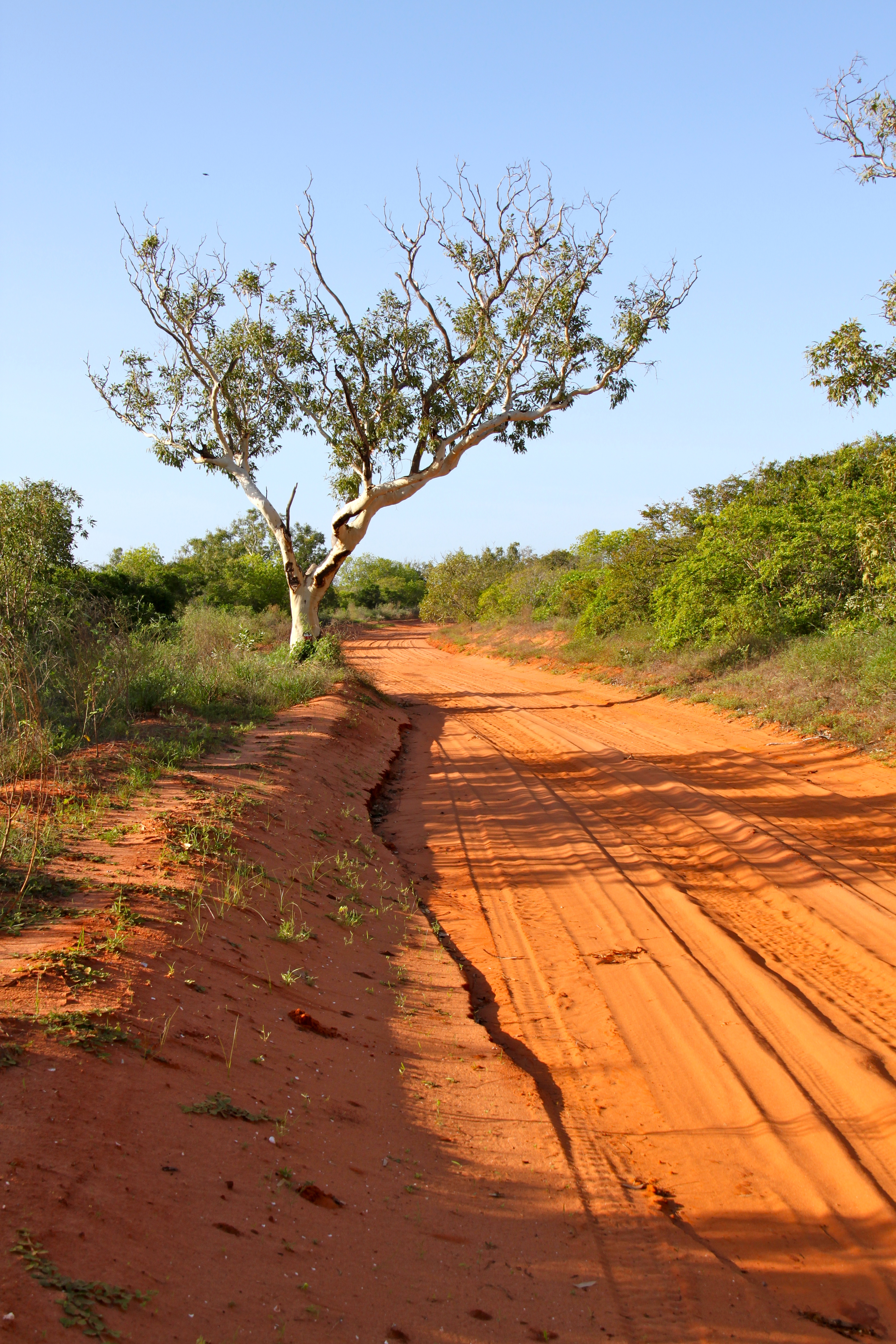
The Cape Leveque Road is a regional Western Australian road that runs through pindan woodland for between Broome and Cape Leveque on the Dampier Peninsula. The southernmost section was narrow-sealed, the northernmost section (between south of Beagle Bay and its northern terminus) was sealed, and the middle section was unsealed. During the wet season, the unsealed section was often closed because flooding made it impassable. The road is vital for servicing communities on the Dampier Peninsula and is also a popular tourist attraction. The road is maintained by the Shire of Broome. Upgrades In May 2018, Main Roads Western Australia, an agency of the Government of Western Australia, started work to upgrade and seal Cape Leveque Road between Broome Highway and Beagle Bay. This work was funded under the Northern Australia Roads Program, with $65.7 million from the state and federal governments, and was completed in late 2020. It included both reconstruction and sealing of th ... [...More Info...] [...Related Items...] OR: [Wikipedia] [Google] [Baidu] |
Cape Leveque, Western Australia
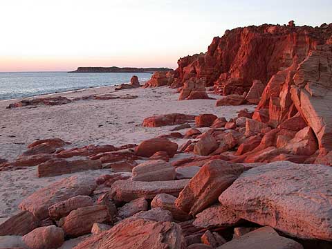
Cape Leveque is at the northernmost tip of the Dampier Peninsula in the Kimberley region of Western Australia. Cape Leveque is (via the Cape Leveque Road) north of Broome, and is remote with few facilities. Nevertheless, the Cape's sandy beaches are attracting an increasing number of visitors. The lighthouse was commissioned at Cape Leveque on 9 August 1911. Its light characteristic is a group of three flashes that occurs every twenty seconds whereby the light source emits from a focal plane of . The lighthouse marks the western entrance of King Sound. Cape Leveque was a camping ground for ancient nomadic people of northern Australia and is probably still being used today. Their huge middens overshadow the small caravan park resting on the shores of the Indian Ocean. Wild turtles and a multitude of sea birds nest on the shores and collect seafood off the exposed rocks at low tide along the shore down the coast to Broome in the southern part of the peninsula. Humpback whales ... [...More Info...] [...Related Items...] OR: [Wikipedia] [Google] [Baidu] |
Dampier Peninsula
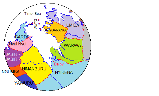
The Dampier Peninsula is a peninsula located north of Broome and Roebuck Bay in Western Australia. It is surrounded by the Indian Ocean to the west and north, and King Sound to the east. It is named after the mariner and explorer William Dampier who visited it. The northernmost part of the peninsula is Cape Leveque. It is sparsely inhabited, mostly by Indigenous Australian peoples, some of whom have been granted native title rights to some of their traditional lands. There are many coastal inlets, bays and other features, including Beagle Bay on its western side. Aboriginal heritage The peninsula is home to a rich heritage of Aboriginal culture, with the communities of Beagle Bay, Bobieding, Djarindjin, Ardyaloon (One Arm Point) and Ngardalargin, along with numerous other smaller communities, pearling camps, tourist resorts and Aboriginal outstations. The traditional owners of the areas around the peninsula are the Bardi, Nyunyul and Jabirr Jabirr (Djaberadjabera) peo ... [...More Info...] [...Related Items...] OR: [Wikipedia] [Google] [Baidu] |
Australian Outback Tracks
Australian(s) may refer to: Australia * Australia, a country * Australians, citizens of the Commonwealth of Australia ** European Australians ** Anglo-Celtic Australians, Australians descended principally from British colonists ** Aboriginal Australians, indigenous peoples of Australia as identified and defined within Australian law * Australia (continent) ** Indigenous Australians * Australian English, the dialect of the English language spoken in Australia * Australian Aboriginal languages * ''The Australian'', a newspaper * Australiana, things of Australian origins Other uses * Australian (horse), a racehorse * Australian, British Columbia, an unincorporated community in Canada See also * The Australian (other) ''The Australian'' is a broadsheet newspaper published in Australia. The Australian may also refer to: Other publications * ''The Australian'' (1824 newspaper), newspaper published in Sydney between 1824 and 1848 * ''The Australian Financial Revi ... ... [...More Info...] [...Related Items...] OR: [Wikipedia] [Google] [Baidu] |
List Of Highways In Western Australia
Highways in Western Australia include both roads that are named as a highway, and roads that have been declared as a highway under the Main Roads Act 1930. The standard of highways range from two-lane roads, common in rural areas, to controlled access, grade separated freeways in Perth. In legislation, a highway is a type of road controlled and maintained by the state road authority, Main Roads Western Australia. Any road or section of road may be proclaimed a highway by the Governor of Western Australia, on the recommendation of the Commissioner of Main Roads, under Section 13 of the Main Roads Act 1930. Section 14 of the act allows for the creation of new highways. Main Roads assigns each highway a name and number, which may vary from the official road names used on road signs and by the general public. The highway number does not correspond to a road route that may be allocated to the highway, and some highways are not part of a numbered route. Proclaimed highways Mai ... [...More Info...] [...Related Items...] OR: [Wikipedia] [Google] [Baidu] |
Highways In Australia
Highways in Australia are generally high capacity roads managed by state and territory government agencies, though Australia's federal government contributes funding for important links between capital cities and major regional centres. Prior to European settlement, the earliest needs for trade and travel were met by narrow bush tracks, used by tribes of Indigenous Australians. The formal construction of roads began in 1788, after the founding of the colony of New South Wales, and a network of three major roads across the colony emerged by the 1820s. Similar road networks were established in the other colonies of Australia. Road construction programs in the early 19th century were generally underfunded, as they were dependent on government budgets, loans, and tolls; while there was a huge increase in road usage, due to the Australian gold rushes. Local government authorities, often known as Road Boards, were therefore established to be primarily responsible for funding and ... [...More Info...] [...Related Items...] OR: [Wikipedia] [Google] [Baidu] |
Government Of Western Australia
The Government of Western Australia, formally referred to as His Majesty's Government of Western Australia, is the States and territories of Australia, Australian state democratic administrative authority of Western Australia. It is also commonly referred to as the WA Government or the Western Australian Government. The Government of Western Australia, a parliamentary system, parliamentary constitutional monarchy, was formed in 1890 as prescribed in its Constitution, as amended from time to time. Since the Federation of Australia, Federation of Australia in 1901, Western Australia has been a state of the Australian Government, Commonwealth of Australia, and the Constitution of Australia regulates its relationship with the Commonwealth. Under the Australian Constitution, Western Australia ceded legislative and judicial supremacy to the Commonwealth, but retained powers in all matters not in conflict with the Commonwealth. History Executive and judicial powers Western Australia ... [...More Info...] [...Related Items...] OR: [Wikipedia] [Google] [Baidu] |
Main Roads Western Australia
Main Roads Western Australia (formerly the Main Roads Department) is a statutory authority of the Government of Western Australia that is responsible for implementing the state's policies on road access and main roads. It operates under the ''Main Roads Act 1930'' (WA). As at June 2021, it manages of roads, representing the arterial road network in Western Australia. Each of the roads must be declared a "public highway" or "main road" in the '' Western Australian Government Gazette'' and is allocated a highway or main road number – many roads perceived as main roads by the public are in fact managed by local councils. Main Roads Western Australia also regulates heavy vehicles through the issue of permits and notices under the authority granted to the Commissioner of Main Roads under the Road Traffic Act 1974. The Road Transport Compliance Section, a section within the Department, employs Transport Inspectors who, alongside police officers, monitor heavy vehicle movement an ... [...More Info...] [...Related Items...] OR: [Wikipedia] [Google] [Baidu] |
Shire Of Broome
The Shire of Broome is one of the four local government areas in the Kimberley region of northern Western Australia, covering an area of , most of which is sparsely populated. The Shire's estimated population as at the was 16,222 most of whom reside in the town of Broome. Many Aboriginal communities are within the Shire, notably Beagle Bay and Bardi (One Arm Point). The Shire of Broome includes the Rowley Shoals to the west. History The Shire of Broome was first established as the second Broome Road District on 20 December 1918, when it was separated from the West Kimberley Road District. The area had been previously represented by an earlier Broome Road District (1901-1908) and the Municipality of Broome (1904-1918) but both had merged back into the West Kimberley district. It was declared a shire with effect from 1 July 1961 following the passage of the ''Local Government Act 1960'', which reformed all remaining road districts into shires. Elected council The Shire i ... [...More Info...] [...Related Items...] OR: [Wikipedia] [Google] [Baidu] |
Cape Leveque
Cape Leveque is at the northernmost tip of the Dampier Peninsula in the Kimberley region of Western Australia. Cape Leveque is (via the Cape Leveque Road) north of Broome, and is remote with few facilities. Nevertheless, the Cape's sandy beaches are attracting an increasing number of visitors. The lighthouse was commissioned at Cape Leveque on 9 August 1911. Its light characteristic is a group of three flashes that occurs every twenty seconds whereby the light source emits from a focal plane of . The lighthouse marks the western entrance of King Sound. Cape Leveque was a camping ground for ancient nomadic people of northern Australia and is probably still being used today. Their huge middens overshadow the small caravan park resting on the shores of the Indian Ocean. Wild turtles and a multitude of sea birds nest on the shores and collect seafood off the exposed rocks at low tide along the shore down the coast to Broome in the southern part of the peninsula. Humpback whales ... [...More Info...] [...Related Items...] OR: [Wikipedia] [Google] [Baidu] |
Lombadina
Lombadina is a medium-sized Aboriginal community on the north-western coast of Western Australia on Cape Leveque, north of Broome in the Kimberley region. The name is derived from the Aboriginal word, "Lollmardinard". The community is inhabited by the Bardi people. Lombadina is part of a single urban area that incorporates Djarindjin and Lombadina. At the 2016 Census, this single urban area had a total population of 397, including 312 Aboriginal and Torres Strait Islander people. The Catholic mission was established with the help of Thomas Puertollano, a Filipino from Manila, in 191011. In 1916, to avoid it being taken over by the government of Western Australia, the land was bought by an Irishman, the brother of the controversial Redemptorist priest, John Creagh. Native title The community is located within the determined Bardi Jawi (WAD49/1998) native title claim area. Education Children of school age at Lombadina attend the Lombadina-Djarindjin Catholic Primary Sc ... [...More Info...] [...Related Items...] OR: [Wikipedia] [Google] [Baidu] |
Woodland
A woodland () is, in the broad sense, land covered with trees, or in a narrow sense, synonymous with wood (or in the U.S., the '' plurale tantum'' woods), a low-density forest forming open habitats with plenty of sunlight and limited shade (see differences between British, American, and Australian English explained below). Woodlands may support an understory of shrubs and herbaceous plants including grasses. Woodland may form a transition to shrubland under drier conditions or during early stages of primary or secondary succession. Higher-density areas of trees with a largely closed canopy that provides extensive and nearly continuous shade are often referred to as forests. Extensive efforts by conservationist groups have been made to preserve woodlands from urbanization and agriculture. For example, the woodlands of Northwest Indiana have been preserved as part of the Indiana Dunes. Definitions United Kingdom ''Woodland'' is used in British woodland management t ... [...More Info...] [...Related Items...] OR: [Wikipedia] [Google] [Baidu] |
Pindan
Pindan is a name given to the red-soil country of the south-western Kimberley region of Western Australia. The term comes from a local language and applies both to the soil and to the vegetation community associated with it.Lowe (2003). History The word “pindan” was first mentioned in print in 1883 by Mr Edward Townley Hardman (1845 1887) in a preliminary appendix to John Forrest’s report on the Kimberley. He stated: “The only metalliferous deposits as yet observed by me are pindan ironstone, a poor hematite, but in large quantity; and in the Fitzroy gravels, quantities of minute dark heavy grains, which have all the appearance of stream tin. These await further chemical examination, In these gravels, opal, cats-eye, garnet, and amethyst occur, all of inferior quality so far as at present observed. The 1891 report on the General Description and Physical Geography of the Kimberley District by Government Geologist Harry Page Woodward described the Pliocene geological forma ... [...More Info...] [...Related Items...] OR: [Wikipedia] [Google] [Baidu] |


