|
California Northern Railroad
The California Northern Railroad is one of several Class III short-line railroad companies owned by Genesee & Wyoming, Inc. It operates over Southern Pacific Railroad (SP) tracks (now Union Pacific Railroad) under a long-term lease. The CFNR was originally owned by the Park-Sierra Rail Group (owner David L. Parkinson of St. Helena, California), who also owned the Arizona and California Railroad and the Puget Sound and Pacific Railroad. The CFNR was later sold to RailAmerica in 2002. Genesee & Wyoming, another shortline holding company, bought RailAmerica in December 2012. The railroad transports mainly food and agricultural commodities, as well as stone products. It moved around 26,000 carloads of goods in 2008. Lines Operated SP & Old NWP (Suisun/Fairfield - Willits) Current Suisun/Fairfield - Schellville Presently, the CFNR only operates between Suisun/ Fairfield to a connection with the Northwestern Pacific Railroad at Schellville, California. The CFNR also operated ... [...More Info...] [...Related Items...] OR: [Wikipedia] [Google] [Baidu] |
EMD GP15-1
The EMD GP15-1 is a 4-axle diesel-electric locomotive built by General Motors Electro-Motive Division between June 1976 and March 1982. Intended to provide an alternative to the rebuilding programs that many railroads were applying to their early road switchers, it is generally employed as a yard switcher or light road switcher. This locomotive is powered by a 12-cylinder EMD 645E engine, which generates . The GP15-1 uses a frame, has a wheelbase of and has a length over couplers of . A total of 310 units were built for American railroads. A number of GP15-1s remain in service today for yard work and light road duty. The radiator section is similar to those found on the EMD SD40T-2 and EMD SD45T-2 "tunnel motors," leading some observers to incorrectly identify the units as such or as GP15Ts, and giving them the nickname "baby tunnel motors". Original Owners Missouri Pacific Railroad The Missouri Pacific Railroad purchased more units than the other three buyers combined. For spot ... [...More Info...] [...Related Items...] OR: [Wikipedia] [Google] [Baidu] |
Amtrak California
Amtrak California is a brand name used by the California Department of Transportation (Caltrans) Division of Rail for three state-supported Amtrak commuter rail routes in Californiathe ''Capitol Corridor'', the ''Pacific Surfliner'', and the ''San Joaquins''and their associated connecting network of Thruway Motorcoach buses. History The National Railroad Passenger Corporation (Amtrak) assumed operation of almost all intercity passenger rail in the United States in 1971. Service in California, as in most of the United States, was basic and infrequent. In 1976 California began providing financial assistance to Amtrak. At the same time, the Caltrans Division of Rail was formed to oversee state-financed rail operations and the brand Amtrak California started appearing on state-supported routes. In 1990, California passed Propositions 108 and 116, providing $3 billion for transportation projects ($ billion after inflation), with a large portion going to rail service. As a re ... [...More Info...] [...Related Items...] OR: [Wikipedia] [Google] [Baidu] |
Willows, California
Willows is a city and the county seat of Glenn County, California, located in the Sacramento Valley region of Northern California. The city is a home to regional government offices, including the California Highway Patrol, California Department of Motor Vehicles, the United States Bureau of Reclamation and the main offices of the Mendocino National Forest, which comprises about one million acres (404,686 ha) of Federal land located mostly in mountainous terrain west of Willows. The population was 6,293 at the 2020 census. History The Willow post office opened in 1862; the name was changed to Willows in 1916. The current post office building, which was built in 1918, is listed on the National Register of Historic Places. The Willows Auxiliary Field (1942-1945) was used for training World War II pilots. Geography According to the United States Census Bureau, the city has a total area of , of which, of it is land and of it (0.92%) is water. Climate Willows has a Hot-summer ... [...More Info...] [...Related Items...] OR: [Wikipedia] [Google] [Baidu] |
Williams, California
Williams (formerly Central) is a city in Colusa County, California. The population was 5,643 at the time of the 2010 census, up from 3,670 at the 2000 census. Geography According to the United States Census Bureau, the city has a total area of , all of it land. History The postal service established a post office at Central in 1874. The town and post office were renamed in 1876, in honor of W. H. Williams, who platted the townsite. The city of Williams was incorporated in 1920. Demographics 2000 At the 2000 census there were 3,670 people in 924 households, including 745 families, in the city. The population density was . There were 968 housing units at an average density of . The racial makeup of the city was 45.45% White, 0.49% Black or African American, 1.14% Native American, 1.14% Asian, 45.50% from other races, and 6.27% from two or more races. 71.20% of the population were Hispanic or Latino of any race. Of the 924 households 51.3% had children under the age of 18 l ... [...More Info...] [...Related Items...] OR: [Wikipedia] [Google] [Baidu] |
Knight's Landing, California
Knights Landing (formerly, Baltimore and East Grafton) is a census-designated place in Yolo County, California, United States, founded by William Knight. It is located on the Sacramento River around 25 miles northwest of Sacramento in the northeastern portion of the county. Knights Landing's ZIP Code is 95645 and its area code 530. It lies at an elevation of 36 feet (11 m). The 2010 census reported that Knights Landing had a population of 995. Geography According to the United States Census Bureau, the CDP covers an area of 0.5 square miles (1.3 km), all of it land. Climate According to the Köppen Climate Classification system, Knights Landing has a warm-summer Mediterranean climate, abbreviated "Csa" on climate maps. Demographics The 2010 United States Census reported that Knights Landing had a population of 995. The population density was . The racial makeup of Knights Landing was 560 (56.3%) White, 4 (0.4%) African American, 10 (1.0%) Native American, 7 (0.7%) A ... [...More Info...] [...Related Items...] OR: [Wikipedia] [Google] [Baidu] |
Marysville, California
Marysville is a city and the county seat of Yuba County, California, located in the Gold Country region of Northern California. As of the 2010 United States Census, the population was 12,072, reflecting a decrease of 196 from the 12,268 counted in the 2000 Census. It is part of the Yuba-Sutter area of Greater Sacramento. History Marysville is located on the ancestral land of the Maidu, who occupied the area for 10,000 years prior to the arrival of Jedediah Smith and trappers from the Hudson Bay Company in 1828, who were the first non-natives to explore the area. Spanish and Mexican explorers never reached that far north on the Feather River. In 1842, John Sutter leased part of his Rancho New Helvetia land to Theodore Cordua, a native of Mecklenburg in Germany, who raised livestock, and in 1843 built a home and trading post he called New Mecklenburg. The trading post and home was situated at what would later become the southern end of 'D' Street, Marysville's main street. In ... [...More Info...] [...Related Items...] OR: [Wikipedia] [Google] [Baidu] |
Yuba City, California
Yuba City (Maidu: ''Yubu'') is a city in Northern California and the county seat of Sutter County, California, United States. The population was 70,117 at the 2020 census. Yuba City is the principal city of the Yuba City Metropolitan Statistical Area which encompasses all of Sutter County and Yuba County. The metro area's population is 164,138. It is the 21st largest metropolitan area in California, ranked behind Redding and Chico. Its metropolitan statistical area is part of the Greater Sacramento CSA. History Early history The Maidu people were settled in the region when they were first encountered by Spanish and Mexican scouting expeditions in the early 18th century. One version of the origin of the name "Yuba" is that during one of these expeditions, wild grapes were seen growing by a river, and so it was named "Uba", a variant spelling of the Spanish word ''uva'' (grape). The Mexican government granted a large expanse of land, which included the area in which Yuba City ... [...More Info...] [...Related Items...] OR: [Wikipedia] [Google] [Baidu] |
Tehama, California
Tehama (Wintun for "high water") is a city in Tehama County, California, United States. The population was 418 at the 2010 census, down from 432 at the 2000 census. Etymology Tehama is most commonly believed to be derived from the Wintun word for "high water", though there are others definitions that have been proposed such as "low land", "salmon", "mother nature" or "shallow" — any of which would be an accurate description of a location where the river is normally shallow enough to ford, where fishermen are a common sight during the salmon run, and winter floods are a regular occurrence. History A Nomlaki village of Wintun people once stood on the site of modern-day Tehama on the western bank of the Sacramento River. Tehama (pronounced Tuh-HAY-muh) was founded by Robert Hasty Thomes, who arrived in the area that is now Tehama County in the company of Albert G. Toomes, William Chard, and Job Francis Dye. The four men travelled northward from San Francisco, and were e ... [...More Info...] [...Related Items...] OR: [Wikipedia] [Google] [Baidu] |
Woodland, California
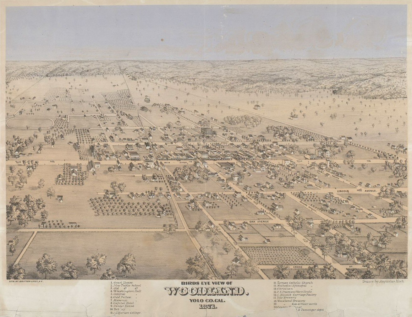
Woodland is a city in and the county seat of Yolo County, California, located approximately northwest of Sacramento, California, Sacramento, and is a part of the Sacramento metropolitan area. The population was 61,032 at the 2020 United States Census, 2020 census. Woodland's origins date to 1850 when California gained statehood and Yolo County was established. Since then the town has grown steadily. The area was well irrigated due to the efforts of James Moore, which drew people into farming as the soil was very fertile. The city gained a federal post office and the next year the county seat was moved from Washington (present day West Sacramento, California) to Woodland after Washington was flooded. The addition of a railroad line to Sacramento, and the more recent addition of Interstate 5 in California, Interstate 5, helped the city to thrive. History Indigenous culture Before its human settlement, settlement by people of European ethnic groups, European descent, the Woodlan ... [...More Info...] [...Related Items...] OR: [Wikipedia] [Google] [Baidu] |
Fort Bragg, California
Fort Bragg, officially the City of Fort Bragg, is a city along the Pacific Coast of California along Shoreline Highway in Mendocino County. The city is west of Willits, at an elevation of . Its population was 6,983 at the 2020 census. Fort Bragg is a tourist destination because of its views of the Pacific Ocean. Among its notable points of interest are Glass Beach and the California Western Railroad (popularly known as the "Skunk Train"). A California Historical Landmark, Fort Bragg was founded in 1857 prior to the American Civil War as a military garrison rather than a fortification. It was named after army officer Braxton Bragg, who at the time had served the U.S. in the Mexican–American War (and would later serve in the Confederate Army during the Civil War). The city was later incorporated in 1889. History The area now known as Fort Bragg was home to Native Americans since before Western expansion, most of whom belong to the Pomo tribe. They historically were h ... [...More Info...] [...Related Items...] OR: [Wikipedia] [Google] [Baidu] |
California Western Railroad
The California Western Railroad , AKA Mendocino Railway popularly called the Skunk Train, is a rail freight and heritage railroad transport railway in Mendocino County, California, United States, running from the railroad's headquarters in the coastal town of Fort Bragg to the interchange with the Northwestern Pacific Railroad at Willits. The CWR runs steam and diesel-powered trains and rail motor cars through Redwood forests along Pudding Creek and the Noyo River. Along the way, the tracks cross some 30 single bridges and trestles and pass through two deep mountain tunnels. The halfway point, short of Northspur, is a popular meal and beverage spot for the railroad's passengers. History The railroad was originally built by the Fort Bragg Redwood Company as the Fort Bragg Railroad in 1885 to carry coast redwood logs from the dense forests at Glenela (Glen Blair) to a newly built lumber mill located to the west at coastal Fort Bragg. Fort Bragg Redwood Company was incorporate ... [...More Info...] [...Related Items...] OR: [Wikipedia] [Google] [Baidu] |
Eureka, California
Eureka (Wiyot: ''Jaroujiji'', Hupa: ''do'-wi-lotl-ding'', Karuk: ''uuth'') is the principal city and county seat of Humboldt County in the Redwood Empire region of California. The city is located on U.S. Route 101 on the shores of Humboldt Bay, north of San Francisco and south of the Oregon border. At the 2010 census, the population of the city was 27,191, and the population of Greater Eureka was 45,034. Eureka is the largest coastal city between San Francisco and Portland, Oregon, and the westernmost city of more than 25,000 residents in the 48 contiguous states.Eureka (city), California , State & County QuickFacts, January 10, 2013, note: in data set The proximity to the sea causes the city to have an extremely maritime clim ... [...More Info...] [...Related Items...] OR: [Wikipedia] [Google] [Baidu] |
.jpg)


