|
Cagayan Valley Road
Cagayan Valley Road is a major highway that connects the cities and municipalities of the province of Cagayan, Philippines. The road forms part of National Route 1 (N1), National Route 103 (N103) and National Route 101 (N101) of the Philippine highway network. Its segment from Lal-lo to Tuguegarao is also a component of the Pan-Philippine Highway, also known as Maharlika Highway and designated as Asian Highway 26 (AH26). Route description Cagayan Valley Road is northernmost road in Cagayan that connects Aparri to Tuguegarao City, running in parallel to Cagayan River, the country's longest river. It also refers to the alternate name of Maharlika Highway that reaches south up to the Central Luzon province of Bulacan. Aparri to Lal-lo The road's Junction Aparri Airport–Port section starts as Loriga Gallarza Street at the Aparri Port in the northern coastal town of Aparri that also serves ferries to Batanes. It traverses the town proper and turns south as De Rivera Street. At th ... [...More Info...] [...Related Items...] OR: [Wikipedia] [Google] [Baidu] |
AH26 (N1) Sign
The Pan-Philippine Highway, also known as the Maharlika Highway ( tl, Daang Maharlika; ceb, Dalang Halangdon), is a network of roads, expressways, bridges, and ferry services that connect the islands of Luzon, Samar, Leyte, and Mindanao in the Philippines, serving as the country's principal transport backbone. Measuring long excluding sea routes, it is the longest highway in the Philippines that forms the country's north–south backbone component of N1 highway (Philippines), National Route 1 (N1) of the Philippine highway network. The entire highway is designated as Asian Highway 26 (AH26) of the Asian Highway Network. The northern terminus of the highway is in Laoag and the southern terminus is in Zamboanga City. History The Pan-Philippine Highway System was an infrastructure program of President of the Philippines, President Diosdado Macapagal as a first priority project for the improvement and expansion of Philippine highway and land transport networks. It was stated ... [...More Info...] [...Related Items...] OR: [Wikipedia] [Google] [Baidu] |
Amulung
Amulung, officially the Municipality of Amulung, is a 2nd class municipality in the province of Cagayan, Philippines. According to the 2020 census, it has a population of 50,336 people. Amulung is from Tuguegarao and from Manila. Etymology From the fruit tree ''Goniothalamus amuyon'' or amuyon/amuyong in Ilocano. Fr. Jose Bugarin's dictionary "amulung, a type of vine, with fig-like leaves, well used for reducing swelling/inflammation lsothe name of a town in this province." Geography Barangays Amulung is politically subdivided into 47 barangays. These barangays are headed by elected officials: Barangay Captain, Barangay Council, whose members are called Barangay Councilors. All are elected every three years. Climate Demographics In the 2020 census, the population of Amulung was 50,336 people, with a density of . Economy Government Amulung, belonging to the third legislative district of the province of Cagayan, is governed by a mayor designated as its local ... [...More Info...] [...Related Items...] OR: [Wikipedia] [Google] [Baidu] |
Isabela (province)
; gad, Probinsia na Isabela; tl, Lalawigan ng Isabela) , settlement_type = , image_skyline = , image_caption = (from top: left to right) Pacific coast in Dinapigue, Sierra Madre Mountains, Magat Dam, Cagayan River in Jones, Aerial view of Divilacan and Cabigan Church Ruins in San Pablo. , image_flag = Flag of Isabela (province).svg , flag_size = 120x80px , image_seal = Official Seal of Isabela.svg , seal_size = 100x80px , nickname = , motto = , image_map = , map_alt = , map_caption = Location in the Philippines , coordinates = , subdivision_type = Country , subdivision_name = , subdivision_type1 = Region , subdivision_name1 = , established_title = Founded , established_date = May 01, 1856 , seat_type = Capi ... [...More Info...] [...Related Items...] OR: [Wikipedia] [Google] [Baidu] |
N1 Highway (Philippines)
National Route 1 (N1) is a primary national route that forms part of the Philippine highway network, running from Luzon to Mindanao. Except for a gap in Metro Manila and ferry connections, the highway is generally continuous. Most sections of N1 forms the Pan-Philippine Highway except for sections bypassed by expressways. Route description N1 follows a route that runs from Laoag in Ilocos Norte to Zamboanga City via Bicol Region, Eastern Visayas and eastern parts of Mindanao. The highway connects most major regional centers on its route and runs through different landscapes. The highway is mostly named Maharlika Highway, but other sections use different names. Ilocos Region N1 begins at the intersection with N2 (Manila North Road) and N100 ( Laoag Airport Road) in Laoag as Manila North Road (''MaNor''). It then crosses Padsan River via Gilbert Bridge and enters the city proper of Laoag, where it splits before turning to the east in front of Ilocos Norte Provincial Capitol, br ... [...More Info...] [...Related Items...] OR: [Wikipedia] [Google] [Baidu] |
Batanes
Batanes, officially the Province of Batanes ( ivv, Provinsiya nu Batanes; Ilocano: ''Probinsia ti Batanes''; fil, Lalawigan ng Batanes, ), is an archipelagic province in the Philippines, administratively part of the Cagayan Valley region. It is the northernmost province in the country, and also the smallest, both in population and land area. The capital is Basco, located on the island of Batan. The island group is located approximately north of the Luzon mainland and about south of Taiwan ( Pingtung County), separated from the Babuyan Islands of Cagayan Province by the Balintang Channel, and from Taiwan by the Bashi Channel. The entire province is listed in the UNESCO tentative list for inscription in the World Heritage List. The government has been finalizing the site's inscription, establishing museums and conservation programs since 2001. Seven intangible heritage elements of the Ivatan have been set by the Philippine government in its initial inventory in 2012. The e ... [...More Info...] [...Related Items...] OR: [Wikipedia] [Google] [Baidu] |
Bulacan
Bulacan, officially the Province of Bulacan ( tl, Lalawigan ng Bulacan), is a province in the Philippines located in the Central Luzon region. Its capital is the city of Malolos. Bulacan was established on August 15, 1578, and part of the Metro Luzon Urban Beltway Super Region. It has 569 barangays in 20 municipalities and four component cities (Baliuag, Malolos the provincial capital, Meycauayan, and San Jose del Monte). Bulacan is located immediately north of Metro Manila. Bordering Bulacan are the provinces of Pampanga to the west, Nueva Ecija to the north, Aurora and Quezon to the east, and Metro Manila and Rizal to the south. Bulacan also lies on the north-eastern shore of Manila Bay. In the 2020 census, Bulacan had a population of 3,708,890 people, the most populous in Central Luzon and the third most populous in the Philippines, after Cebu and Cavite. Bulacan's most populated city is San Jose del Monte, the most populated municipality is Santa Maria while the least po ... [...More Info...] [...Related Items...] OR: [Wikipedia] [Google] [Baidu] |
Central Luzon
Central Luzon ( pam, (Reyun ning) Kalibudtarang Luzon, pag, (Rehiyon na) Pegley na Luzon, tgl, (Rehiyon ng) Gitnang Luzon, ilo, (Rehion/Deppaar ti) Tengnga ti Luzon), designated as Region III, is an administrative region in the Philippines, primarily serving to organize the 7 provinces of the vast central plains of the island of Luzon (the largest island), for administrative convenience. The region contains the largest plain in the country and produces most of the country's rice supply, earning itself the nickname "Rice Granary of the Philippines". Its provinces are: Aurora, Bataan, Bulacan, Nueva Ecija, Pampanga, Tarlac and Zambales. Pangasinan was formerly a province of Central Luzon before President Marcos signed ''Presidential Decree No. 1'', 1972, incorporating it into Ilocos Region. Additionally, the province of Aurora was part of the defunct political region Southern Tagalog when the region was divided into Calabarzon and Mimaropa, upon the issuance of ''Executive Ord ... [...More Info...] [...Related Items...] OR: [Wikipedia] [Google] [Baidu] |
Cagayan River
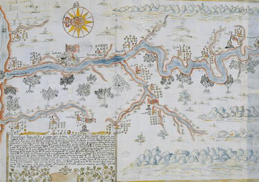
The Cagayan River, also known as the Río Grande de Cagayán, is the longest river and the largest river by discharge volume of water in the Philippines. It has a total length of approximately and a drainage basin covering . It is located in the Cagayan Valley region in northeastern part of Luzon Island and traverses the provinces of Nueva Vizcaya, Quirino, Isabela and Cagayan. Topography The river's headwaters are at the Caraballo Mountains of the Central Luzon at an elevation of approximately . The river flows north for some to its mouth at the Babuyan Channel near the town of Aparri, Cagayan. The river drops rapidly to above sea level some from the river mouth. Its principal tributaries are the Pinacanauan, Chico, Siffu, Mallig, Magat and Ilagan Rivers. Magat River, is the largest tributary with an estimated annual discharge of 9,808 million cubic meters. It lies in the southwestern portion of the basin, stretching approximately from Nueva Vizcaya down to i ... [...More Info...] [...Related Items...] OR: [Wikipedia] [Google] [Baidu] |
Pan-Philippine Highway
The Pan-Philippine Highway, also known as the Maharlika Highway ( tl, Daang Maharlika; ceb, Dalang Halangdon), is a network of roads, expressways, bridges, and ferry services that connect the islands of Luzon, Samar, Leyte, and Mindanao in the Philippines, serving as the country's principal transport backbone. Measuring long excluding sea routes, it is the longest highway in the Philippines that forms the country's north–south backbone component of N1 highway (Philippines), National Route 1 (N1) of the Philippine highway network. The entire highway is designated as Asian Highway 26 (AH26) of the Asian Highway Network. The northern terminus of the highway is in Laoag and the southern terminus is in Zamboanga City. History The Pan-Philippine Highway System was an infrastructure program of President of the Philippines, President Diosdado Macapagal as a first priority project for the improvement and expansion of Philippine highway and land transport networks. It was stated ... [...More Info...] [...Related Items...] OR: [Wikipedia] [Google] [Baidu] |
Philippine Highway Network
The Philippine highway network is a network of national roads owned and maintained by the Department of Public Works and Highways (DPWH) and organized into three classifications according to their function or purpose: national primary, secondary, and tertiary roads. The national roads connecting major cities are numbered from N1 to N83. They are mostly single and dual carriageways linking two or more cities. As of October 15, 2019, it has a total length of of concrete roads, of asphalt roads, of gravel roads, and of earth roads, with a grand total of . According to a 2011 report from the Asian Development Bank, the extent of the road network in the Philippines is comparable with or better than many neighboring developing countries in Southeast Asia. However, in terms of the quality of the road system, i.e., the percentage of paved roads and the percentage of those in good or fair condition, the country lagged behind its neighbors . Classification The national roads in the ... [...More Info...] [...Related Items...] OR: [Wikipedia] [Google] [Baidu] |
Philippines
The Philippines (; fil, Pilipinas, links=no), officially the Republic of the Philippines ( fil, Republika ng Pilipinas, links=no), * bik, Republika kan Filipinas * ceb, Republika sa Pilipinas * cbk, República de Filipinas * hil, Republika sang Filipinas * ibg, Republika nat Filipinas * ilo, Republika ti Filipinas * ivv, Republika nu Filipinas * pam, Republika ning Filipinas * krj, Republika kang Pilipinas * mdh, Republika nu Pilipinas * mrw, Republika a Pilipinas * pag, Republika na Filipinas * xsb, Republika nin Pilipinas * sgd, Republika nan Pilipinas * tgl, Republika ng Pilipinas * tsg, Republika sin Pilipinas * war, Republika han Pilipinas * yka, Republika si Pilipinas In the recognized optional languages of the Philippines: * es, República de las Filipinas * ar, جمهورية الفلبين, Jumhūriyyat al-Filibbīn is an archipelagic country in Southeast Asia. It is situated in the western Pacific Ocean and consists of around 7,641 islands t ... [...More Info...] [...Related Items...] OR: [Wikipedia] [Google] [Baidu] |
Peñablanca
Peñablanca, officially the Municipality of Peñablanca ( ibg, Ili nat Peñablanca; ilo, Ili ti Peñablanca; tl, Bayan ng Peñablanca), is a 1st class municipality in the province of Cagayan, Philippines. According to the 2020 census, it has a population of 50,300 people. Situated east of the provincial capital Tuguegarao and north of Manila, the municipality is home to the Peñablanca Protected Landscape and Seascape which contains the Callao Cave (part of the Callao Limestone Formation Paleolithic Archaeological Site), one of the province's well-known landmarks and tourist spots. It is also home to the charcoal-drawn Peñablanca petrographs. Both the Peñablanca petrographs and the Callao Limestone Formation are included as tentative sites of the Philippines for future inclusion in the UNESCO World Heritage List. The Callao Limestone Formation has at least 93 archaeological sites that yielded stone tools of Paleolithic industry and bones and shells of animals still liv ... [...More Info...] [...Related Items...] OR: [Wikipedia] [Google] [Baidu] |


.jpg)