|
Bundesstraße 27
Bundesstraße 27 or B27 is a German federal road. It connects Blankenburg am Harz with Rafz in Switzerland. Route The Bundesstraße 27 crosses the following states and towns (north to south): * Saxony-Anhalt: Blankenburg am Harz * Lower Saxony: Braunlage, Göttingen * Hesse: Sontra, Bad Hersfeld, Fulda * Bavaria: Hammelburg, Würzburg * Baden-Württemberg: Tauberbischofsheim, Heilbronn, Ludwigsburg, Stuttgart, Tübingen, Rottweil, Donaueschingen, Jestetten The B27 is interrupted in two places: between Würzburg and Tauberbischofsheim, where it has been replaced by the motorways A3 and A81, and between Randen and Jestetten, where it crosses through Switzerland. The part south of Stuttgart follows the ''Schweizer Straße'' (Suisse road), a chaussee from 18th century. D ST Rübeland HVLE 285001 Sz 20080511.jpg, in the Harz mountains Stuttgart-pragsatteltunnel-2006-06-05-bigcat.jpg, interchange with B 10 in Stuttgart B27 Tübingen.jpg, in the Neckar valley See also *List ... [...More Info...] [...Related Items...] OR: [Wikipedia] [Google] [Baidu] |
Saxony-Anhalt
Saxony-Anhalt (german: Sachsen-Anhalt ; nds, Sassen-Anholt) is a state of Germany, bordering the states of Brandenburg, Saxony, Thuringia and Lower Saxony. It covers an area of and has a population of 2.18 million inhabitants, making it the 8th-largest state in Germany by area and the 11th-largest by population. Its capital is Magdeburg and its largest city is Halle (Saale). The state of Saxony-Anhalt was formed in July 1945 after World War II, when the Soviet army administration in Allied-occupied Germany formed it from the former Prussian Province of Saxony and the Free State of Anhalt. Saxony-Anhalt became part of the German Democratic Republic in 1949, but was dissolved in 1952 during administrative reforms and its territory divided into the districts of Halle and Magdeburg. Following German reunification the state of Saxony-Anhalt was re-established in 1990 and became one of the new states of the Federal Republic of Germany. Saxony-Anhalt is renowned for its ri ... [...More Info...] [...Related Items...] OR: [Wikipedia] [Google] [Baidu] |
Heilbronn
Heilbronn () is a List of cities and towns in Germany, city in northern Baden-Württemberg, Germany, surrounded by Heilbronn (district), Heilbronn District. With over 126,000 residents, it is the sixth-largest city in the state. From the late Middle Ages, it developed into an important trading centre. At the beginning of the 19th century, Heilbronn became one of the centres of early industrialisation in Württemberg. Heilbronn's old town was completely destroyed during the air raid of 4 December 1944 and rebuilt in the 1950s. Today Heilbronn is the economic centre of the Heilbronn-Franconia, Heilbronn-Franken region. Heilbronn is known for its wine industry and is nicknamed ''Käthchenstadt'', after Heinrich von Kleist's ''Das Käthchen von Heilbronn''. Geography Heilbronn is located in the northern corner of the Neckar Sedimentary basin, basin at the bottom of the Wartberg (Heilbronn), Wartberg (308 m). It occupies both banks of the Neckar, and the highest spot inside city limit ... [...More Info...] [...Related Items...] OR: [Wikipedia] [Google] [Baidu] |
Neckar
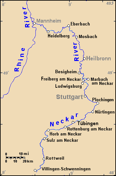
The Neckar () is a river in Germany, mainly flowing through the southwestern state of Baden-Württemberg, with a short section through Hesse. The Neckar is a major right tributary of the Rhine. Rising in the Schwarzwald-Baar-Kreis near Schwenningen in the ''Schwenninger Moos'' conservation area at a height of above sea level, it passes through Rottweil, Rottenburg am Neckar, Kilchberg, Tübingen, Wernau, Nürtingen, Plochingen, Esslingen, Stuttgart, Ludwigsburg, Marbach, Heilbronn and Heidelberg, before discharging on average of water into the Rhine at Mannheim, at above sea level, making the Neckar its 4th largest tributary, and the 10th largest river in Germany. Since 1968, the Neckar has been navigable for cargo ships via 27 locks for about upstream from Mannheim to the river port of Plochingen, at the confluence with the Fils. From Plochingen to Stuttgart, the Neckar valley is densely populated and heavily industrialised, with several well-known companies. Between ... [...More Info...] [...Related Items...] OR: [Wikipedia] [Google] [Baidu] |
Bundesstraße 10
The Bundesstraße 10 (abbr. B10) is a German federal highway. It leads from Eppelborn, near the city of Lebach in Saarland, eastward to Neusäß near Augsburg in Bavaria. The Bundesautobahn 8 mostly runs in parallel to the Bundesstraße 10. After a very short strip near Eppelborn leading to the Bundesautobahn 1, the road continues at Pirmasens. Because the construction of the A 8 through the Pfälzerwald never commenced, the Bundesstraße 10 has to carry the east-west traffic, though plans to upgrade the road to four lanes are underway. At Landau, the Bundesautobahn 65 replaces the Bundesstraße 10 up to the city of Wörth am Rhein, from where it continues to Karlsruhe, crossing the river Rhine, through Pforzheim, the city of Stuttgart, Göppingen, Ulm up to Neusäß, shortly before the city of Augsburg. Especially the part in Baden-Württemberg suffers from heavy traffic and high congestion, and there are attempts to improve the traffic situation by upgrading the road. Originall ... [...More Info...] [...Related Items...] OR: [Wikipedia] [Google] [Baidu] |
Harz
The Harz () is a highland area in northern Germany. It has the highest elevations for that region, and its rugged terrain extends across parts of Lower Saxony, Saxony-Anhalt, and Thuringia. The name ''Harz'' derives from the Middle High German word ''Hardt'' or ''Hart'' (hill forest). The name ''Hercynia'' derives from a Celtic name and could refer to other mountain forests, but has also been applied to the geology of the Harz. The Brocken is the highest summit in the Harz with an elevation of above sea level. The Wurmberg () is the highest peak located entirely within the state of Lower Saxony. Geography Location and extent The Harz has a length of , stretching from the town of Seesen in the northwest to Eisleben in the east, and a width of . It occupies an area of , and is divided into the Upper Harz (''Oberharz'') in the northwest, which is up to 800 m high, apart from the 1,100 m high Brocken massif, and the Lower Harz (''Unterharz'') in the east which is up to aroun ... [...More Info...] [...Related Items...] OR: [Wikipedia] [Google] [Baidu] |
Chaussee
''Chaussee'' is an historic term used in German-speaking countries for early, metalled, rural highways, designed by road engineers, as opposed to the hitherto, traditional, unpaved country roads. The term is no longer used in modern road construction in Western Europe, but survives in road names and is used by historians. In Eastern Europe and the post Soviet states it remains a generic term for a common paved highway outside of built-up areas, but they may transition into prospekts within towns and cities. Origin of the word and usage The German word was borrowed from the French by the German construction industry in the 18th century. The French word, in turn, went back to the Gallo-Romanic and meant a road surfaced with firmly compacted crushed rock bound with lime. :fr:Chaussée Contemporary German translations of the word were ('road embankment') and ('high way') and even the roughly similar English word, highway. Around 1790, Adelung complained that "several new auth ... [...More Info...] [...Related Items...] OR: [Wikipedia] [Google] [Baidu] |
Blumberg
For the town in South Australia previously called Blumberg, see Birdwood, South Australia. Blumberg is a municipality situated in the Schwarzwald-Baar region of Baden-Württemberg, Germany. Nineteen kilometres south of Donaueschingen, it lies between the southern edge of the ''Schwarzwald'', the Black Forest, the border with Switzerland’s Canton of Schaffhausen, and Lake Constance. History The town of Blumberg is in the region where the ancient source for the Danube is situated, the former glacial valley between Eichberg and Buchberg, and its official origins date from the 13th Century with the ''Masters of Blumberg'' first mentioned in 1260. However one of the oldest settlements, the ''Steppacher Hof'', was already documented in the 12th century, and the town itself is believed to have originated long before that time as archaeological finds have shown the area was inhabited during the Stone Age. The Wutach is a 90km long tributary of the River Rhine that changes nam ... [...More Info...] [...Related Items...] OR: [Wikipedia] [Google] [Baidu] |
Bundesautobahn 81
is a motorway in Germany. It branches off the A 3 at the Würzburg-West triangle and ends near the border with Switzerland. The oldest part of the A 81 between the Weinsberg intersection ( A 6) near Heilbronn and Dreieck Leonberg ( A 8) near Stuttgart was finished in the years 1938 to 1940. This section included the first tunnel built for an autobahn, the first Engelberg tunnel near Leonberg. When Weinsberg-Leonberg was upgraded to 3+3 lanes in the 1970s, the tunnel with its two lanes each and steep grades (up to 6%) became something of a bottleneck. In 1999 a new Engelberg tunnel was opened. Original plans called for the A 81 to be continued northwards skirting the north-west of Würzburg to join up with the A 7, but these plans were later abandoned. Instead, the A 81 shares a part of the A 8 to the Stuttgart intersection and then continues south on a motorway that was built as A 831 to Gärtringen, where it meets the original l ... [...More Info...] [...Related Items...] OR: [Wikipedia] [Google] [Baidu] |
Bundesautobahn 3
is an autobahn in Germany running from the Germany-Netherlands border near Wesel in the northwest to the Germany-Austria border near Passau. Major cities along its total length of 778 km (483 mi) include Oberhausen, Duisburg, Düsseldorf, Leverkusen, Cologne, Wiesbaden, Frankfurt, Würzburg, Nuremberg and Regensburg. The A 3 is a major connection between the Rhine-Ruhr area and southern Germany, resulting in heavy traffic. Consequently, large parts have three lanes (plus a hard shoulder) in each direction, including a 300 km (187.5 mi) section between Oberhausen and Aschaffenburg. The A3 passes by the Frankfurt Airport. Overview The A 3 begins at the border crossing Elten in North Rhine-Westphalia as a four-lane continuation of the Dutch A 12. Until Oberhausen the highway runs on the right bank of the Lower Rhine past the cities Emmerich, Wesel and Dinslaken and reaches the Ruhrgebiet. Beginning at the ''Kreuz Oberhausen'' with A 516 and A 2, the A ... [...More Info...] [...Related Items...] OR: [Wikipedia] [Google] [Baidu] |
Jestetten
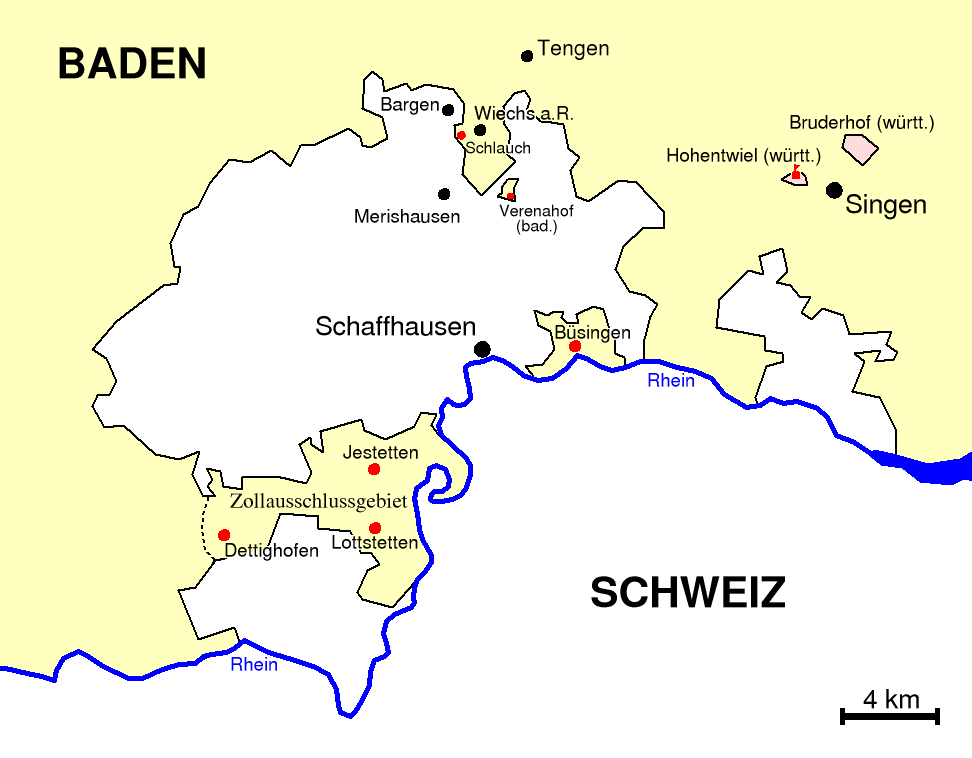
Jestetten is a municipality in the district of Waldshut in Baden-Württemberg in Germany. History In 1806 Jestetten became part of Baden. From 1840 until 1935, the territory of Jestetten together with Altenburg, Lottstetten and what was then Dettighofen, was part of the region which formed a customs exclusion zone and was not part of the German customs area. Inhabitants were able to offer their produce to the rest of Germany as well as to Switzerland. This situation brought about a higher standard of living and prosperity compared to the rest of Germany. Geography The border crossing into Switzerland is located to the east of town along Schaffhauserstraße leading to Neuhausen am Rheinfall. Another border crossing in the municipality is located south west of town along Osterfingerstraße, towards the villager of Osterfingen in Wilchingen municipality, Schaffhausen canton. Transport Jestetten railway station is situated on the Swiss Federal Railway's cross-border Eglisau-Ne ... [...More Info...] [...Related Items...] OR: [Wikipedia] [Google] [Baidu] |
Donaueschingen
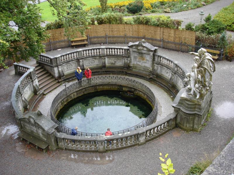
Donaueschingen (; Low Alemannic: ''Eschinge'') is a German town in the Black Forest in the southwest of the federal state of Baden-Württemberg in the Schwarzwald-Baar '' Kreis''. It stands near the confluence of the two sources of the river Danube (in german: Donau). Donaueschingen stands in a basin within low mountainous terrain. It is located about south of Villingen-Schwenningen, west of Tuttlingen, and about north of the Swiss town of Schaffhausen. In 2015 the population was 21,750, making it the second largest town in the district (''Kreis'') of Schwarzwald-Baar. It is a regional rail hub. Geography Donaueschingen lies in the Baar basin in the southern Black Forest at the confluence of the Brigach and Breg rivers—the two source tributaries of the Danube—from which the town gets its name. This is today considered the true source of the Danube. An enclosed karst spring on the castle grounds, the source of the "Donaubach", is known as the source of the Danube ... [...More Info...] [...Related Items...] OR: [Wikipedia] [Google] [Baidu] |
Rottweil
Rottweil (; Alemannic: ''Rautweil'') is a town in southwest Germany in the state of Baden-Württemberg. Rottweil was a free imperial city for nearly 600 years. Located between the Black Forest and the Swabian Alps, Rottweil has nearly 25,000 inhabitants as of 2020. The town is famous for its medieval center and for its traditional carnival (called "Fasnet" in the local Swabian dialect). It is the oldest town in Baden-Württemberg, and its appearance has changed very little since the 16th century. The town gives its name to the Rottweiler dog breed. History Rottweil was founded by the Romans in AD 73 as Arae Flaviae and became a ''municipium'', but there are traces of human settlement going back to 2000 BC. Roman baths and an Orpheus mosaic of c. AD 180 date from the time of Roman settlement. The present town became a ducal and a royal court before 771 and in 1268 it became a free imperial city. In 1463 Rottweil joined the Swiss Confederacy under the pretence of a tempo ... [...More Info...] [...Related Items...] OR: [Wikipedia] [Google] [Baidu] |


.jpg)