|
Bundenbach
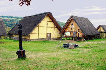
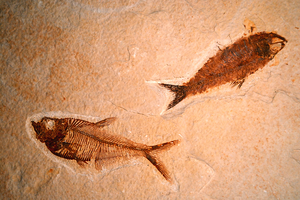
Bundenbach is an ''Ortsgemeinde'' – a municipality belonging to a ''Verbandsgemeinde'', a kind of collective municipality – in the Birkenfeld district of Rhineland-Palatinate, Germany. It belongs to the ''Verbandsgemeinde'' Herrstein-Rhaunen, whose seat is in Herrstein. For its roughly 400-million-year-old fossils of Placodermi and other creatures from the Devonian, Bundenbach is said to be a world-class fossil ''Lagerstätte''. Geography Location The municipality lies on the ''Hunsrück Schiefer- und Burgenstraße'' (“Hunsrück Slate and Castle Road”). Neighbouring municipalities The nearest major towns are Kirn, Idar-Oberstein and Simmern. Neighbouring municipalities are Rhaunen, Bollenbach, Schneppenbach and Bruschied. Constituent communities Also belonging to Bundenbach are the outlying homesteads of Neumühle and Reinhardsmühle. History The area was settled in protohistory, which is proven by digs undertaken by the Rheinisches Landesmuseum Trier (Trier Rhenis ... [...More Info...] [...Related Items...] OR: [Wikipedia] [Google] [Baidu] |
Schneppenbach
Schneppenbach is an ''Ortsgemeinde'' – a municipality belonging to a ''Verbandsgemeinde'', a kind of collective municipality – in the Bad Kreuznach district in Rhineland-Palatinate, Germany. It belongs to the ''Verbandsgemeinde'' Kirner Land, whose seat is in the town of Kirn. Geography Location Schneppenbach lies in the southern Hunsrück on the western edge of the Lützelsoon ridge and east of (above) the Hahnenbach valley. The nearest major towns are Idar-Oberstein (17 km to the south-southwest) and Simmern (17 km to the north-northeast). Schneppenbach sits at an elevation of 424 m above sea level. Neighbouring municipalities Clockwise from the north, Schneppenbach's neighbours are the municipalities of Woppenroth, which lies in the neighbouring Rhein-Hunsrück-Kreis, Bruschied, which lies in the Bad Kreuznach district, and Bundenbach, which lies in the neighbouring Birkenfeld district. History From the Early Middle Ages, Schneppenbach belonged to a m ... [...More Info...] [...Related Items...] OR: [Wikipedia] [Google] [Baidu] |
Bruschied
Bruschied is an ''Ortsgemeinde A Verbandsgemeinde (; plural Verbandsgemeinden) is a low-level administrative division, administrative unit in the Germany, German States of Germany, federal states of Rhineland-Palatinate and Saxony-Anhalt. A Verbandsgemeinde is typically compose ...'' – a Municipalities of Germany, municipality belonging to a ''Verbandsgemeinde'', a kind of collective municipality – in the Bad Kreuznach (district), Bad Kreuznach Districts of Germany, district in Rhineland-Palatinate, Germany. It belongs to the ''Verbandsgemeinde'' Kirner Land, whose seat is in the town of Kirn. Geography Location Bruschied lies in the southern Hunsrück, west of the Lützelsoon plateau. The Lützelsoon Cycleway (''Lützelsoon-Radweg'') runs through the village. Land use As at 31 December 2009, land use in Bruschied breaks down thus: * Agriculture: 37.6% * Woodland: 45.8% * Open water: 1.0% * Residential and transport: 15.6% Neighbouring municipalities Clockwise from the n ... [...More Info...] [...Related Items...] OR: [Wikipedia] [Google] [Baidu] |
Rhaunen
Rhaunen is an ''Ortsgemeinde'' – a municipality belonging to a ''Verbandsgemeinde'', a kind of collective municipality – in the Birkenfeld district in Rhineland-Palatinate, Germany. It was the seat of the former ''Verbandsgemeinde'' Rhaunen. Geography Location The municipality lies at the Idar Forest in the Hunsrück in a sprawling, well watered hollow. The hollow separates the Idar Forest massif from the Soonwald massif. Within the village itself, the Lingenbach empties into the Rhaunelbach, which itself, along with the Näßbach, the Macherbach and the Büdenbach, empties into the Idarbach. The nearest major centres are Idar-Oberstein, Simmern, Morbach and Kirn. Constituent communities Also belonging to Rhaunen are the outlying centre of Neuzenbrunnen and the homesteads of Hochwälderhof and Königstein. Geology The solid rock in Rhaunen, Hunsrück slate, comes down from the Devonian. The hollow in which Rhaunen lies was formed by the many brooks that flow together her ... [...More Info...] [...Related Items...] OR: [Wikipedia] [Google] [Baidu] |
Bollenbach
Bollenbach is an ''Ortsgemeinde'' – a municipality belonging to a ''Verbandsgemeinde'', a kind of collective municipality – in the Birkenfeld district in Rhineland-Palatinate, Germany. It belongs to the ''Verbandsgemeinde'' Herrstein-Rhaunen, whose seat is in Herrstein. Geography This is full of green land spreading for over 57 miles. It has many block huts built forming small cities. It is nearly abandoned. Location The municipality lies in the Hunsrück, east of the Idar Forest. Neighbouring municipalities Bollenbach borders in the north on Rhaunen, in the east on Bundenbach and in the southwest on Sulzbach. History In the Middle Ages, Bollenbach was made up of two parts, the ''Hochgericht'' (“ High Court”) and the ''Ingericht'', which belonged respectively to the two lordly houses of Schmidtburg and Wildenburg. The “boundary” between these two parts of the village is unaccountably still visible today as a bare strip on which nothing has been built, running throug ... [...More Info...] [...Related Items...] OR: [Wikipedia] [Google] [Baidu] |
Lagerstätte
A Lagerstätte (, from ''Lager'' 'storage, lair' '' Stätte'' 'place'; plural ''Lagerstätten'') is a sedimentary deposit that exhibits extraordinary fossils with exceptional preservation—sometimes including preserved soft tissues. These formations may have resulted from carcass burial in an anoxic environment with minimal bacteria, thus delaying the decomposition of both gross and fine biological features until long after a durable impression was created in the surrounding matrix. ''Lagerstätten'' span geological time from the Neoproterozoic era to the present. Worldwide, some of the best examples of near-perfect fossilization are the Cambrian Maotianshan shales and Burgess Shale, the Silurian Waukesha Biota, the Devonian Hunsrück Slates and Gogo Formation, the Carboniferous Mazon Creek, the Jurassic Posidonia Shale and Solnhofen Limestone, the Cretaceous Yixian, Santana, and Agua Nueva formations, the Eocene Green River Formation, the Miocene Foulden Maar and Ashfall F ... [...More Info...] [...Related Items...] OR: [Wikipedia] [Google] [Baidu] |
Birkenfeld (district)
Birkenfeld () is a district (''Landkreis'') in Rhineland-Palatinate, Germany. Its seat is the town of Birkenfeld. It is bounded by (from the south and clockwise) the districts of Sankt Wendel (Saarland), Trier-Saarburg, Bernkastel-Wittlich, Rhein-Hunsrück, Bad Kreuznach and Kusel. History In the early nineteenth century, the Nahe River was the boundary between two tiny principalities: Birkenfeld, west of the Nahe; and Lichtenberg, east of it. The principality of Birkenfeld was annexed by Oldenburg in 1817; Lichtenberg became an exclave of the Duchy Saxe-Coburg (Saxe-Coburg-Saalfeld until 1826, Saxe-Coburg and Gotha thereafter). Prussia bought Lichtenberg in 1834 and made it the District of Sankt Wendel. After World War I, the southern half of Sankt Wendel had to be ceded to the newly created Saar Territory, and the small part remaining in Prussia was then officially called the ''Restkreis Sankt Wendel'' ("remaining district of Sankt Wendel"). In 1937 the Oldenburgian Dist ... [...More Info...] [...Related Items...] OR: [Wikipedia] [Google] [Baidu] |
Celts
The Celts (, see pronunciation for different usages) or Celtic peoples () are. "CELTS location: Greater Europe time period: Second millennium B.C.E. to present ancestry: Celtic a collection of Indo-European peoples. "The Celts, an ancient Indo-European people, reached the apogee of their influence and territorial expansion during the 4th century bc, extending across the length of Europe from Britain to Asia Minor."; . " e Celts, were Indo-Europeans, a fact that explains a certain compatibility between Celtic, Roman, and Germanic mythology."; . "The Celts and Germans were two Indo-European groups whose civilizations had some common characteristics."; . "Celts and Germans were of course derived from the same Indo-European stock."; . "Celt, also spelled Kelt, Latin Celta, plural Celtae, a member of an early Indo-European people who from the 2nd millennium bce to the 1st century bce spread over much of Europe."; in Europe and Anatolia, identified by their use of Celtic langua ... [...More Info...] [...Related Items...] OR: [Wikipedia] [Google] [Baidu] |
Herrstein-Rhaunen
Herrstein-Rhaunen is a ''Verbandsgemeinde'' ("collective municipality") in the district of Birkenfeld, Rhineland-Palatinate, Germany. The seat of the ''Verbandsgemeinde'' is in Herrstein. It was formed on 1 January 2020 by the merger of the former ''Verbandsgemeinden'' Herrstein and Rhaunen. The ''Verbandsgemeinde'' Herrstein-Rhaunen consists of the following ''Ortsgemeinden'' ("local municipalities"): # Allenbach # Asbach # Bergen # Berschweiler bei Kirn # Bollenbach # Breitenthal # Bruchweiler # Bundenbach # Dickesbach # Fischbach # Gerach # Gösenroth # Griebelschied # Hausen # Hellertshausen # Herborn # Herrstein # Hettenrodt # Hintertiefenbach # Horbruch # Hottenbach # Kempfeld # Kirschweiler # Krummenau # Langweiler # Mackenrodt # Mittelreidenbach # Mörschied # Niederhosenbach # Niederwörresbach # Oberhosenbach # Oberkirn # Oberreidenbach # Oberwörresbach # Rhaunen # Schauren # Schmidthachenbach # Schwerbach # Sensweiler # Si ... [...More Info...] [...Related Items...] OR: [Wikipedia] [Google] [Baidu] |
Rheinisches Landesmuseum Trier
The ''Rheinische Landesmuseum Trier'' is an archaeological museum in Trier, Germany. The collection stretches from prehistory through the Roman period, the Middle Ages to the Baroque era with a strong emphasis on the Roman past of Augusta Treverorum, Germany's oldest city. Its collections of (local) Roman sculptures, Roman mosaics and frescos are among the best in Germany (along with those of the Römisch-Germanisches Museum in Cologne, the Rheinisches Landesmuseum Bonn and the Römisch-Germanisches Zentralmuseum in Mainz). History The museum was founded in 1877 as the Provincial Museum of the Prussian Rhine Province (''Provinzialmuseum der preußischen Rheinprovinz''), of which the Rheinisches Landesmuseum Bonn was also part. The first director was the archaeologist Felix Hettner (1877–1902). In 1885–89 a proper museum building was built at the edge of the palace garden of the Electoral Palace, just outside the Roman wall. The architect of the building, rectangular and ... [...More Info...] [...Related Items...] OR: [Wikipedia] [Google] [Baidu] |
Protohistory
Protohistory is a period between prehistory and history during which a culture or civilization has not yet developed writing, but other cultures have already noted the existence of those pre-literate groups in their own writings. For example, in Europe, the Celts and the Germanic tribes are considered to have been protohistoric when they began appearing in Greek and Roman sources. Protohistoric may also refer to the transition period between the advent of literacy in a society and the writings of the first historians. The preservation of oral traditions may complicate matters, as they can provide a secondary historical source for even earlier events. Colonial sites involving a literate group and a nonliterate group are also studied as protohistoric situations. The term can also refer to a period in which fragmentary or external historical documents, not necessarily including a developed writing system, have been found. For instance, the Proto–Three Kingdoms of Korea, the Yayo ... [...More Info...] [...Related Items...] OR: [Wikipedia] [Google] [Baidu] |
Trier
Trier ( , ; lb, Tréier ), formerly known in English as Trèves ( ;) and Triers (see also names in other languages), is a city on the banks of the Moselle in Germany. It lies in a valley between low vine-covered hills of red sandstone in the west of the state of Rhineland-Palatinate, near the border with Luxembourg and within the important Moselle wine region. Founded by the Celts in the late 4th century BC as ''Treuorum'' and conquered 300 years later by the Romans, who renamed it ''Augusta Treverorum'' ("The City of Augustus among the Treveri"), Trier is considered Germany's oldest city. It is also the oldest seat of a bishop north of the Alps. Trier was one of the four capitals of the Roman Empire during the Tetrarchy period in the late 3rd and early 4th centuries. In the Middle Ages, the archbishop-elector of Trier was an important prince of the Church who controlled land from the French border to the Rhine. The archbishop-elector of Trier also had great signific ... [...More Info...] [...Related Items...] OR: [Wikipedia] [Google] [Baidu] |


