|
Botwood
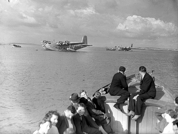
Botwood is a town in north-central Newfoundland, Newfoundland and Labrador, Canada in Census Division 6. It is located on the west shore of the Bay of Exploits on a natural deep water harbour used by cargo ships and seaplanes throughout the town's history. Botwood was the North American terminus for the first transatlantic commercial flights. History In 1908, construction began on the Botwood Railway; the railway ran between Bishop's Falls and Botwood. It was a joint effort between the A.N.D. Company and the A. E. Reed Company of Bishop's Falls. It was to be the transportation link for the export of pulp and paper from the newly built mill at Grand Falls, NL. The railway became operational by the fall of 1909, and the first shipment of paper from the new mill was sent in February 1910. The A.N.D. Company took control of the railway operation in 1910, just a year after the line was completed. The first aircraft facility to be established in Botwood was by Newfoundland born Capta ... [...More Info...] [...Related Items...] OR: [Wikipedia] [Google] [Baidu] |
Pan Am
Pan American World Airways, originally founded as Pan American Airways and commonly known as Pan Am, was an American airline that was the principal and largest international air carrier and unofficial overseas flag carrier of the United States for much of the 20th century. It was the first airline to fly worldwide and pioneered numerous innovations of the modern airline industry such as jumbo jets, and computerized reservation systems. Until its dissolution in 1991, Pan Am "epitomized the luxury and glamour of intercontinental travel", and it remains a cultural icon of the 20th century, identified by its blue globe logo ("The Blue Meatball"), the use of the word "Clipper" in its aircraft names and call signs, and the white uniform caps of its pilots. Founded in 1927 by two former U.S. Army Air Corps majors, Pan Am began as a scheduled airmail and passenger service flying between Key West, Florida, and Havana, Cuba. Under the leadership of American entrepreneur Juan Trippe, in t ... [...More Info...] [...Related Items...] OR: [Wikipedia] [Google] [Baidu] |
Seaplane
A seaplane is a powered fixed-wing aircraft capable of takeoff, taking off and water landing, landing (alighting) on water.Gunston, "The Cambridge Aerospace Dictionary", 2009. Seaplanes are usually divided into two categories based on their technological characteristics: floatplanes and flying boats; the latter are generally far larger and can carry far more. Seaplanes that can also take off and land on airfields are in a subclass called amphibious aircraft, or amphibians. Seaplanes were sometimes called ''hydroplanes'', but currently this term applies instead to Hydroplane (boat), motor-powered watercraft that use the technique of Planing (boat), hydrodynamic lift to skim the surface of water when running at speed. The use of seaplanes gradually tapered off after World War II, partially because of the investments in airports during the war but mainly because landplanes were less constrained by weather conditions that could result in sea states being too high to operate seaplan ... [...More Info...] [...Related Items...] OR: [Wikipedia] [Google] [Baidu] |
List Of Newfoundland And Labrador Highways
This is a list of highways in Newfoundland and Labrador. Newfoundland and Labrador is unusual among jurisdictions in Canada in that it exclusively uses highway marker signs that do not use either the province's name, symbols, or other official insignia. Main provincial highways List of Newfoundland and Labrador highways that traverse both the island and mainland part of the province and those that lead into distinct regions of the province. Regional roads Main transportation routes leading into and around the various regions of the province sorted by regions. Avalon Peninsula and Isthmus Region * Route 2, Pitts Memorial Drive and Peacekeeper's Way * Route 3, Robert E. Howlett Memorial Drive * Route 3A, Team Gushue Highway * Route 10, Southern Shore Highway (eastern side of Irish Loop Drive) * Route 11, Petty Harbour Road * Route 13, Witless Bay Line * Route 20, Torbay Road and Pouch Cove Road * Route 21, Bauline Line * Route 30, Logy Bay Road *Route 40, Portuga ... [...More Info...] [...Related Items...] OR: [Wikipedia] [Google] [Baidu] |
Area Code 709
Area code 709 is the telephone area code in the North American Numbering Plan (NANP) for the entire Canadian province of Newfoundland and Labrador. History The first telephone system was installed in Newfoundland in 1885, but domestic long-distance calls within the Dominion of Newfoundland could be placed on a limited basis only in 1921. The first long-distance call from Newfoundland to Canada was made on January 10, 1939, by using a shortwave radio link operated by the Canadian Marconi Company in Montréal. Shortwave radio also carried calls from St. John's to London, England. When planning was completed for the original NANP area codes in 1947, Newfoundland had not yet become of part of the Dominion of Canada. No provisions had been made to include Newfoundland in the continental numbering plan, which later became the North American Numbering Plan. The Newfoundland telephone system was entirely manual, and dial telephones came to St. John's only in 1948. After Newfoundland's ... [...More Info...] [...Related Items...] OR: [Wikipedia] [Google] [Baidu] |
List Of A Postal Codes Of Canada
__NOTOC__ This is a list of postal codes in Canada where the first letter is A. Postal codes beginning with A are located within the Canadian province of Newfoundland and Labrador. Only the first three characters are listed, corresponding to the Forward Sortation Area. Canada Post provides a free postal code look-up tool on its website, via its mobile apps for such smartphones as the iPhone and BlackBerry, and sells hard-copy directories and CD-ROMs. Many vendors also sell validation tools, which allow customers to properly match addresses and postal codes. Hard-copy directories can also be consulted in all post offices, and some libraries. Newfoundland and Labrador - 35 FSAs Notes: As of May 2007, no postal codes yet begin with A3*, A4*, A6* or A7*. Urban Rural References {{Canadian postal codes Postal codes A postal code (also known locally in various English-speaking countries throughout the world as a postcode, post code, PIN or ZIP Code) is a series of lette ... [...More Info...] [...Related Items...] OR: [Wikipedia] [Google] [Baidu] |
Bishop's Falls
Bishop's Falls is a town in the north-central part of the island of Newfoundland in the Canadian province of Newfoundland and Labrador, with a population of 3,082 at the 2021 census. Geography It is in Division No. 6, on the Exploits River, near the town of Grand Falls-Windsor and the town of Botwood. It is commonly thought of as having the warmest summer temperatures in all of Newfoundland and Labrador. History The railroad played a major part in the area's history, as the town was a central hub during the travels of the "Newfie Bullet" train. There is a trestle in the town which is the longest east of Quebec. The existing trestle is the last of many which were built and destroyed by the strong ice flows (and a flood) that occur in the winter. The town sits along the Exploits River which flows through and to the falls from which the town takes its name. Bishop's Falls also boasts a famous NHL player name, Alex Faulkner who played with Gordie Howe. Demographics In the 202 ... [...More Info...] [...Related Items...] OR: [Wikipedia] [Google] [Baidu] |
Foynes
Foynes (; ) is a town and major port in County Limerick in the midwest of Ireland, located at the edge of hilly land on the southern bank of the Shannon Estuary. The population of the town was 520 as of the 2016 census. Foynes's role as seaport Foynes as a port has a long history, being first surveyed in 1837, and is now the location of a major deep water seaport operated by the Shannon Foynes Port Company, an amalgamation under the Harbours Act 2000 of the agencies operating the ports of Limerick and Foynes. It is anticipated that more traffic from the upstream Limerick Port will ultimately be diverted there as the latter portlands are redeveloped as commercial and residential properties. A railway line to Limerick via Patrickswell Patrickswell, historically known as Toberpatrick (), is a small town in County Limerick, Ireland. It is primarily a commuter village for people working in Limerick, particularly the nearby industrial suburb of Raheen. The population was 847 ... [...More Info...] [...Related Items...] OR: [Wikipedia] [Google] [Baidu] |
Boeing 314
The Boeing 314 Clipper was an American long-range flying boat produced by Boeing from 1938 to 1941. One of the largest aircraft of its time, it had the range to cross the Atlantic and Pacific oceans. For its wing, Boeing re-used the design from the earlier XB-15 bomber prototype. Twelve Clippers were built, nine of which served with Pan Am. Design and development Pan American had requested a truly trans-Pacific flying boat with unprecedented range and double the passenger payload of the airline's Martin M-130. Boeing's bid was successful and on July 21, 1936, Pan American signed a contract for six. Boeing engineers adapted the cancelled XB-15's wing, and replaced the Pratt & Whitney Twin Wasp radial engines with the Wright Twin Cyclone. Pan Am ordered six more aircraft with increased engine power and capacity for 77 daytime passengers as the Boeing 314A. The huge flying boat was assembled at Boeing's Plant 1 on the Duwamish River in Seattle, and towed to Elliott Bay ... [...More Info...] [...Related Items...] OR: [Wikipedia] [Google] [Baidu] |
Bay Of Exploits
The Bay of Exploits is a large bay in the northeast of Newfoundland. It extends from the mouth of the Exploits River and opens on to Notre Dame Bay to the north. It is approximately 1,000 square kilometers (386 sq. miles) in size and contains over 30 islands of which New World Island is the largest. Description The bay probably got its name from early successful encounters with the Beothuk Indians. The main towns are Lewisporte, Twillingate (on the Twillingate Islands in the bay) and Botwood. Salmon fishing and the fur trade were the main early industries. The last of the Beothuk The shores of the Bay of Exploits, the Exploits River and Red Indian Lake at its head, were among the last known haunts of the Beothuk people who generally are thought to have become extinct with the death of Shanawdithit in June 1829, though oral histories Oral history is the collection and study of historical information about individuals, families, important events, or everyday life using audiotape ... [...More Info...] [...Related Items...] OR: [Wikipedia] [Google] [Baidu] |
Sydney Bennett
Sydney John Bennett (7 February 1905 – 15 August 1969) was an English cricketer. Bennett was a right-handed batsman who bowled right-arm slow. He was born at Hackleton, Northamptonshire. Bennett made three first-class appearances for Northamptonshire, two in the 1933 County Championship against Nottinghamshire and Derbyshire Derbyshire ( ) is a ceremonial county in the East Midlands, England. It includes much of the Peak District National Park, the southern end of the Pennine range of hills and part of the National Forest. It borders Greater Manchester to the nor ..., and one in the 1934 County Championship against Leicestershire County Cricket Club, Leicestershire. In his three first-class matches, he scored 37 runs at an batting average (cricket), average of 7.40, with a high score of 19 not out. With the ball he took 2 wickets at a bowling average of 53.50, with best figures of 1/40. He died at Margate, Kent on 15 August 1969. References External linksSydn ... [...More Info...] [...Related Items...] OR: [Wikipedia] [Google] [Baidu] |


