|
Bismarck Imperial-pigeon
The black imperial pigeon (''Ducula melanochroa''), also known as the Bismarck imperial pigeon, is a species of bird in the family Columbidae. It is endemic to the Bismarck Archipelago where it lives in forests. Taxonomy and systematics The black imperial pigeon was originally described as ''Carpophaga melanochroa'' by Philip Sclater in 1878 based on specimens from the Duke of York Islands. The generic name ''Ducula'' is from "dukul", the Nepali name for imperial pigeons. The specific name ''melanochroa'' is from the Ancient Greek word ''melanokhrōs'', meaning black-skinned. Black imperial pigeon is the official common name designated by the International Ornithologists' Union. Other common names for the species include black imperial-pigeon, Bismarck imperial pigeon, Bismarck imperial-pigeon, and silver-laced imperial pigeon. The black imperial pigeon is often placed in a species group with the Pinon's, Louisiade, and collared imperial pigeons. It has no subspecies. ... [...More Info...] [...Related Items...] OR: [Wikipedia] [Google] [Baidu] |
Philip Sclater
Philip Lutley Sclater (4 November 1829 – 27 June 1913) was an England, English lawyer and zoologist. In zoology, he was an expert ornithologist, and identified the main zoogeographic regions of the world. He was Secretary of the Zoological Society of London for 42 years, from 1860–1902. Early life Sclater was born at Tangier Park, in Wootton St Lawrence, Hampshire, where his father William Lutley Sclater had a country house. George Sclater-Booth, 1st Baron Basing was Philip's elder brother. Philip grew up at Hoddington House where he took an early interest in birds. He was educated in school at Twyford and at thirteen went to Winchester College and later Corpus Christi College, Oxford where he studied scientific ornithology under Hugh Edwin Strickland. In 1851 he began to study law and was admitted a Fellow of Corpus Christi College. In 1856 he travelled to America and visited Lake Superior and the upper St. Croix River (Wisconsin–Minnesota), St. Croix River, cano ... [...More Info...] [...Related Items...] OR: [Wikipedia] [Google] [Baidu] |
Collared Imperial Pigeon
The collared imperial pigeon (''Ducula mullerii'') is a large pigeon native to New Guinea and adjacent islands. Description The species has an average body length of 40 cm and weighs about 600 g. It has grey upperparts and largely grey-pink underparts, and is distinguished by a striking and diagnostic complete black collar against an otherwise white throat. Distribution and habitat The collared imperial pigeon occurs in northern and southern New Guinea and the Aru Islands. It has also been recorded from Boigu and Saibai islands. It may visit the northern Torres Strait islands as a vagrant. It inhabits lowland rainforest, swamp forest, mangroves and riverine vegetation. Taxonomy The binomial commemorates the German naturalist Salomon Müller. There are two recognized subspecies: the nominate ''D. m. mullerii'' (Temminck, 1835), in lowland southern New Guinea, including the offshore islands of Boigu, Saibai and Daru, and the Aru Islands; and ''D. m. aurantia'' (A. B. Meyer ... [...More Info...] [...Related Items...] OR: [Wikipedia] [Google] [Baidu] |
IUCN Red List
The International Union for Conservation of Nature (IUCN) Red List of Threatened Species, also known as the IUCN Red List or Red Data Book, founded in 1964, is the world's most comprehensive inventory of the global conservation status of biological species. It uses a set of precise criteria to evaluate the extinction risk of thousands of species and subspecies. These criteria are relevant to all species and all regions of the world. With its strong scientific base, the IUCN Red List is recognized as the most authoritative guide to the status of biological diversity. A series of Regional Red Lists are produced by countries or organizations, which assess the risk of extinction to species within a political management unit. The aim of the IUCN Red List is to convey the urgency of conservation issues to the public and policy makers, as well as help the international community to reduce species extinction. According to IUCN the formally stated goals of the Red List are to provi ... [...More Info...] [...Related Items...] OR: [Wikipedia] [Google] [Baidu] |
International Union For Conservation Of Nature
The International Union for Conservation of Nature (IUCN; officially International Union for Conservation of Nature and Natural Resources) is an international organization working in the field of nature conservation and sustainable use of natural resources. It is involved in data gathering and analysis, research, field projects, advocacy, and education. IUCN's mission is to "influence, encourage and assist societies throughout the world to conserve nature and to ensure that any use of natural resources is equitable and ecologically sustainable". Over the past decades, IUCN has widened its focus beyond conservation ecology and now incorporates issues related to sustainable development in its projects. IUCN does not itself aim to mobilize the public in support of nature conservation. It tries to influence the actions of governments, business and other stakeholders by providing information and advice and through building partnerships. The organization is best known to the wider pu ... [...More Info...] [...Related Items...] OR: [Wikipedia] [Google] [Baidu] |
Least-concern Species
A least-concern species is a species that has been categorized by the International Union for Conservation of Nature (IUCN) as evaluated as not being a focus of species conservation because the specific species is still plentiful in the wild. They do not qualify as threatened, near threatened, or (before 2001) conservation dependent. Species cannot be assigned the "Least Concern" category unless they have had their population status evaluated. That is, adequate information is needed to make a direct, or indirect, assessment of its risk of extinction based on its distribution or population status. Evaluation Since 2001 the category has had the abbreviation "LC", following the IUCN 2001 Categories & Criteria (version 3.1). Before 2001 "least concern" was a subcategory of the "Lower Risk" category and assigned the code "LR/lc" or lc. Around 20% of least concern taxa (3261 of 15636) in the IUCN database still use the code "LR/lc", which indicates they have not been re-evaluate ... [...More Info...] [...Related Items...] OR: [Wikipedia] [Google] [Baidu] |
Ficus
''Ficus'' ( or ) is a genus of about 850 species of woody trees, shrubs, vines, epiphytes and hemiepiphytes in the family Moraceae. Collectively known as fig trees or figs, they are native throughout the tropics with a few species extending into the semi-warm temperate zone. The common fig (''F. carica'') is a temperate species native to southwest Asia and the Mediterranean region (from Afghanistan to Portugal), which has been widely cultivated from ancient times for its fruit, also referred to as figs. The fruit of most other species are also edible though they are usually of only local economic importance or eaten as bushfood. However, they are extremely important food resources for wildlife. Figs are also of considerable cultural importance throughout the tropics, both as objects of worship and for their many practical uses. Description ''Ficus'' is a pantropical genus of trees, shrubs, and vines occupying a wide variety of ecological niches; most are evergreen, bu ... [...More Info...] [...Related Items...] OR: [Wikipedia] [Google] [Baidu] |
Frugivorous
A frugivore is an animal that thrives mostly on raw fruits or succulent fruit-like produce of plants such as roots, shoots, nuts and seeds. Approximately 20% of mammalian herbivores eat fruit. Frugivores are highly dependent on the abundance and nutritional composition of fruits. Frugivores can benefit or hinder fruit-producing plants by either dispersing or destroying their seeds through digestion. When both the fruit-producing plant and the frugivore benefit by fruit-eating behavior the interaction is a form of mutualism. Frugivore seed dispersal Seed dispersal is important for plants because it allows their progeny to move away from their parents over time. The advantages of seed dispersal may have led to the evolution of fleshy fruits, which entice animals to consume them and move the plant's seeds from place to place. While many fruit-producing plant species would not disperse far without frugivores, their seeds can usually germinate even if they fall to the ground directly ... [...More Info...] [...Related Items...] OR: [Wikipedia] [Google] [Baidu] |
Duke Of York Island, Papua New Guinea
Duke of York Island is the largest island of Duke of York Islands, Papua New Guinea, at . The island is named after Prince Edward, the brother of King George III of Great Britain. There is also a Duke of York Island at in North Victoria Land in East-Antarctica Antarctica () is Earth's southernmost and least-populated continent. Situated almost entirely south of the Antarctic Circle and surrounded by the Southern Ocean, it contains the geographic South Pole. Antarctica is the fifth-largest contine ..., at the southern end of Robertson Bay, not far from Cape Adare. Islands of Papua New Guinea {{PapuaNewGuinea-geo-stub ... [...More Info...] [...Related Items...] OR: [Wikipedia] [Google] [Baidu] |
Watom Island
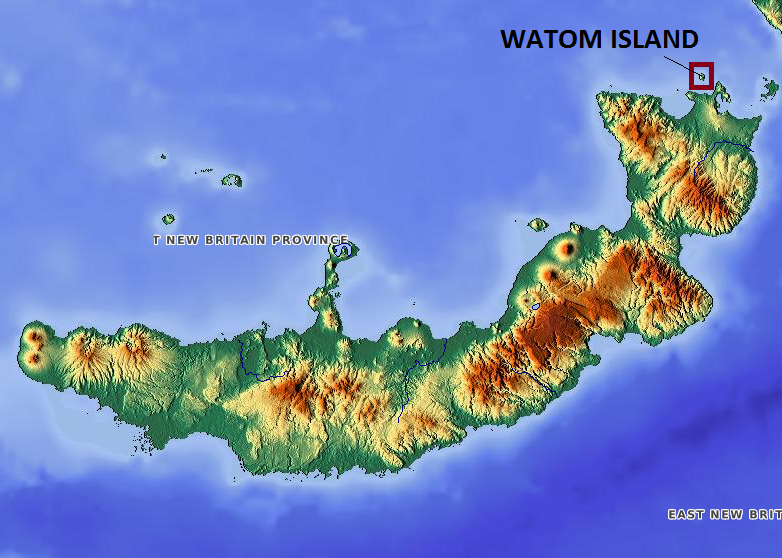
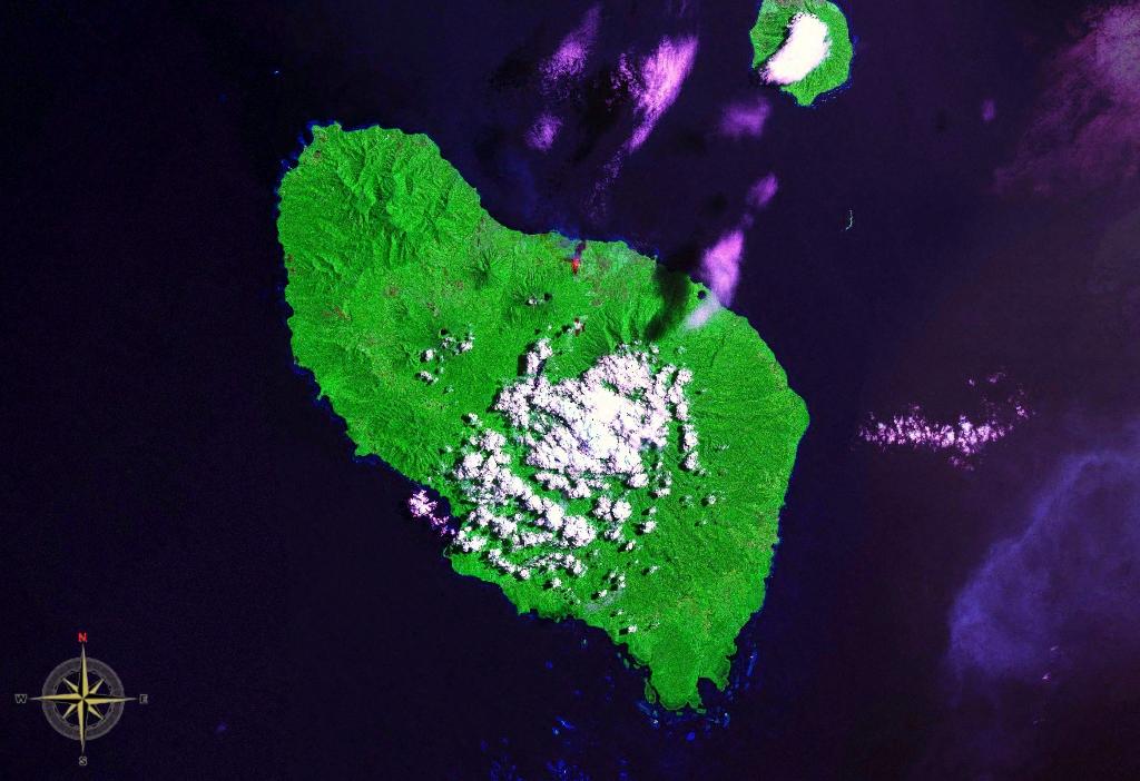
Watom Island is an inhabited island in the Bismarck Sea in Papua New Guinea, located just off the mainland of the northern coast of New Britain, near Rabaul. It lies to the north-east of Urara Island. The island is almost entirely forested except for a few scattered settlements. The highest point of the island approaches 320 metres. Watom's Wall, a "classic wall dive well", located on the northern coast, is a notable diving location. The island is administered under Watom Island Rural LLG in East New Britain Province East New Britain is a province of Papua New Guinea, consisting of the north-eastern part of the island of New Britain and the Duke of York Islands. The capital of the province is Kokopo, not far from the old capital of Rabaul, which was largely d .... During World War II, the island served as a prisoner of war camp for British soldiers captured at Singapore. Only 18 survived out of the original 600 shipped out on the ''Matsa Maru'' in November 1942. The last sur ... [...More Info...] [...Related Items...] OR: [Wikipedia] [Google] [Baidu] |
New Britain
New Britain ( tpi, Niu Briten) is the largest island in the Bismarck Archipelago, part of the Islands Region of Papua New Guinea. It is separated from New Guinea by a northwest corner of the Solomon Sea (or with an island hop of Umboi the Dampier and Vitiaz Straits) and from New Ireland by St. George's Channel. The main towns of New Britain are Rabaul/Kokopo and Kimbe. The island is roughly the size of Taiwan. While the island was part of German New Guinea, it was named Neupommern ("New Pomerania"). In common with most of the Bismarcks it was largely formed by volcanic processes, and has active volcanoes including Ulawun (highest volcano nationally), Langila, the Garbuna Group, the Sulu Range, and the volcanoes Tavurvur and Vulcan of the Rabaul caldera. A major eruption of Tavurvur in 1994 destroyed the East New Britain provincial capital of Rabaul. Most of the town still lies under metres of ash, and the capital has been moved to nearby Kokopo. Geography New Britain e ... [...More Info...] [...Related Items...] OR: [Wikipedia] [Google] [Baidu] |
Umboi Island
Umboi (also named Rooke or Siassi) is a volcanic island between the mainland of Papua New Guinea and the island of New Britain. It is separated from New Britain by the Dampier Strait and Huon Peninsula, and New Guinea by the Vitiaz Strait. It has an elevation of . Languages are Papuan Kobai; and Austronesian: Mbula, Karanai, and Saveng languages. The Siassi Archipelago lies off the southeast coast of Umboi Island (a total of 18 islands, only seven are inhabited). During the mid-1920s, the population of the Siassi Islands was a little over 700 people. It had more than doubled (to almost 1700 people) by the early 1960s, and then decreased to a little more than 1600 people by the early 1980s. The Siassi support themselves through traditional trade based on a barter system; they are important middlemen who deliver pigs, pots and wooden bowls by sea in their canoes. See also * List of volcanoes in Papua New Guinea * Siassi Rural LLG Siassi Rural LLG is a local-level govern ... [...More Info...] [...Related Items...] OR: [Wikipedia] [Google] [Baidu] |
New Ireland (island)
New Ireland (Tok Pisin: ''Niu Ailan'') or Latangai, is a large island in Papua New Guinea, approximately in area with 120,000 people. It is named after the island of Ireland. It is the largest island of New Ireland Province, lying northeast of the island of New Britain. Both islands are part of the Bismarck Archipelago, named after Otto von Bismarck, and they are separated by Saint George's Channel. The administrative centre of the island and of New Ireland province is the town of Kavieng located at the northern end of the island. While the island was part of German New Guinea, it was named Neumecklenburg ("New Mecklenburg"). Geography The island is part of the Bismarck Archipelago and is often described as having the shape of a musket. New Ireland is surrounded by the Bismarck Sea in the southwest and by the Pacific Ocean in the northeast. For much of its in length, the island's width varies between less than to , yet the central mountainous spine is very steep an ... [...More Info...] [...Related Items...] OR: [Wikipedia] [Google] [Baidu] |


