|
Watom Island
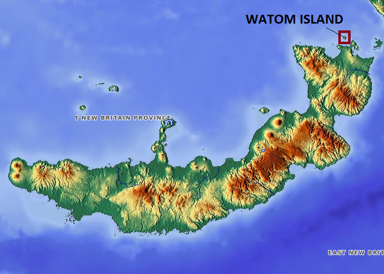
Watom Island is an inhabited island in the Bismarck Sea in Papua New Guinea, located just off the mainland of the northern coast of New Britain, near Rabaul. It lies to the north-east of Urara Island. The island is almost entirely forested except for a few scattered settlements. The highest point of the island approaches 320 metres. Watom's Wall, a "classic wall dive well", located on the northern coast, is a notable diving location. The island is administered under Watom Island Rural LLG in East New Britain Province East New Britain is a province of Papua New Guinea, consisting of the north-eastern part of the island of New Britain and the Duke of York Islands. The capital of the province is Kokopo, not far from the old capital of Rabaul, which was largely d .... During World War II, the island served as a prisoner of war camp for British soldiers captured at Singapore. Only 18 survived out of the original 600 shipped out on the ''Matsa Maru'' in November 1942. The last sur ... [...More Info...] [...Related Items...] OR: [Wikipedia] [Google] [Baidu] |
Bismarck Sea
The Bismarck Sea (, ) lies in the southwestern Pacific Ocean within the nation of Papua New Guinea. It is located northeast of the island of New Guinea and south of the Bismarck Archipelago. It has coastlines in districts of the Islands Region, Momase Region, and Papua Region. Geography Like the Bismarck Archipelago, it is named in honour of the first German Chancellor Otto von Bismarck. The Bismarck Archipelago extends round to the east and north of the sea, enclosing the Bismarck Sea and separating it from the Southern Pacific Ocean. To the south it is linked to the Solomon Sea by the Vitiaz Strait. Official boundaries The International Hydrographic Organization defines the Bismarck Sea as "that area of the Pacific Ocean, South Pacific Ocean off the northeast coast of New Guinea", with the following limits: ''On the North and East.'' By the Northern and Northeastern coasts of the islands of New Ireland (island), New Ireland, New Hanover Island, New Hanover, the Admiralty I ... [...More Info...] [...Related Items...] OR: [Wikipedia] [Google] [Baidu] |
Papua New Guinea
Papua New Guinea (abbreviated PNG; , ; tpi, Papua Niugini; ho, Papua Niu Gini), officially the Independent State of Papua New Guinea ( tpi, Independen Stet bilong Papua Niugini; ho, Independen Stet bilong Papua Niu Gini), is a country in Oceania that comprises the eastern half of the island of New Guinea and its offshore islands in Melanesia (a region of the southwestern Pacific Ocean north of Australia). Its capital, located along its southeastern coast, is Port Moresby. The country is the world's third largest island country, with an area of . At the national level, after being ruled by three external powers since 1884, including nearly 60 years of Australian administration starting during World War I, Papua New Guinea established its sovereignty in 1975. It became an independent Commonwealth realm in 1975 with Elizabeth II as its queen. It also became a member of the Commonwealth of Nations in its own right. There are 839 known languages of Papua New Guinea, one of ... [...More Info...] [...Related Items...] OR: [Wikipedia] [Google] [Baidu] |
New Britain
New Britain ( tpi, Niu Briten) is the largest island in the Bismarck Archipelago, part of the Islands Region of Papua New Guinea. It is separated from New Guinea by a northwest corner of the Solomon Sea (or with an island hop of Umboi the Dampier and Vitiaz Straits) and from New Ireland by St. George's Channel. The main towns of New Britain are Rabaul/Kokopo and Kimbe. The island is roughly the size of Taiwan. While the island was part of German New Guinea, it was named Neupommern ("New Pomerania"). In common with most of the Bismarcks it was largely formed by volcanic processes, and has active volcanoes including Ulawun (highest volcano nationally), Langila, the Garbuna Group, the Sulu Range, and the volcanoes Tavurvur and Vulcan of the Rabaul caldera. A major eruption of Tavurvur in 1994 destroyed the East New Britain provincial capital of Rabaul. Most of the town still lies under metres of ash, and the capital has been moved to nearby Kokopo. Geography New Britain e ... [...More Info...] [...Related Items...] OR: [Wikipedia] [Google] [Baidu] |
Rabaul
Rabaul () is a township in the East New Britain province of Papua New Guinea, on the island of New Britain. It lies about 600 kilometres to the east of the island of New Guinea. Rabaul was the provincial capital and most important settlement in the province until it was destroyed in 1994 by falling ash from a volcanic eruption in its harbour. During the eruption, ash was sent thousands of metres into the air, and the subsequent rain of ash caused 80% of the buildings in Rabaul to collapse. After the eruption the capital was moved to Kokopo, about away. Rabaul is continually threatened by volcanic activity, because it is on the edge of the Rabaul caldera, a flooded caldera of a large pyroclastic shield. Rabaul was planned and built around the harbour area known as Simpsonhafen (Simpson Harbour) during the German New Guinea administration, which controlled the region between 1884 and formally through 1919. Rabaul was selected as the capital of the German New Guinea administratio ... [...More Info...] [...Related Items...] OR: [Wikipedia] [Google] [Baidu] |
Urara Island
Urara Island is a small inhabited island in the northern part of Ataliklikun Bay (Bismarck Sea) in Papua New Guinea, located just off the mainland of the northern coast of New Britain. There are 3 villages, the largest lying on the southern central part of the coastline. Urara Island lies about 3 miles westward of Cape Liguan, and stands on a reef which extends a short distance only eastward of it and 1.5 miles to the westward. Materbert Island lies about 6 miles west of the island and Watom Island lies to the north-east. References External linksGoogle Earth Islands of New Britain East New Britain Province {{PapuaNewGuinea-island-stub ... [...More Info...] [...Related Items...] OR: [Wikipedia] [Google] [Baidu] |
Watom Island Rural LLG
Watom Island Rural LLG is a local-level government (LLG) of East New Britain Province, Papua New Guinea Papua New Guinea (abbreviated PNG; , ; tpi, Papua Niugini; ho, Papua Niu Gini), officially the Independent State of Papua New Guinea ( tpi, Independen Stet bilong Papua Niugini; ho, Independen Stet bilong Papua Niu Gini), is a country i .... Wards *01. Rakival *02. Taranata *03. Valaur *04. Vunabuk *05. Vunakabai *06. Vunaulaiar References * * Local-level governments of East New Britain Province {{EastNewBritainProvince-geo-stub ... [...More Info...] [...Related Items...] OR: [Wikipedia] [Google] [Baidu] |
East New Britain Province
East New Britain is a province of Papua New Guinea, consisting of the north-eastern part of the island of New Britain and the Duke of York Islands. The capital of the province is Kokopo, not far from the old capital of Rabaul, which was largely destroyed in a volcanic eruption in 1994. East New Britain covers a total land area of , and the province's population was reported as 220,133 in the 2000 census, rising to 328,369 in the 2011 count. Provincial coastal waters extend over an area of . The province's only land border is with West New Britain Province to the west, and it also shares a maritime border with New Ireland Province to the east. East New Britain has a dual economy: a cash economy operates side by side with the subsistence-farming sector. The main crops produced for export are cocoa and copra. Tourism continues to be an increasingly important sector of the provincial economy. Languages There are sixteen Austronesian languages spoken in the province, of which Kuanua, ... [...More Info...] [...Related Items...] OR: [Wikipedia] [Google] [Baidu] |
Islands Of New Britain
An island (or isle) is an isolated piece of habitat that is surrounded by a dramatically different habitat, such as water. Very small islands such as emergent land features on atolls can be called islets, skerries, cays or keys. An island in a river or a lake island may be called an eyot or ait, and a small island off the coast may be called a holm. Sedimentary islands in the Ganges delta are called chars. A grouping of geographically or geologically related islands, such as the Philippines, is referred to as an archipelago. There are two main types of islands in the sea: continental and oceanic. There are also artificial islands, which are man-made. Etymology The word ''island'' derives from Middle English ''iland'', from Old English ''igland'' (from ''ig'' or ''ieg'', similarly meaning 'island' when used independently, and -land carrying its contemporary meaning; cf. Dutch ''eiland'' ("island"), German ''Eiland'' ("small island")). However, the spelling of the word ... [...More Info...] [...Related Items...] OR: [Wikipedia] [Google] [Baidu] |
Papua New Guinea In World War II
The New Guinea campaign of the Pacific War lasted from January 1942 until the end of the war in August 1945. During the initial phase in early 1942, the Empire of Japan invaded the Australian-administered Mandated Territory of New Guinea (23 January) and the Australian Territory of Papua (21 July) and overran western New Guinea (beginning 29/30 March), which was a part of the Netherlands East Indies. During the second phase, lasting from late 1942 until the Japanese surrender, the Allies—consisting primarily of Australian forces—cleared the Japanese first from Papua, then the Mandate and finally from the Dutch colony. The campaign resulted in a crushing defeat and heavy losses for the Empire of Japan. As in most Pacific War campaigns, disease and starvation claimed more Japanese lives than enemy action. Most Japanese troops never even came into contact with Allied forces, and were instead simply cut off and subjected to an effective blockade by Allied naval forces. Garrisons ... [...More Info...] [...Related Items...] OR: [Wikipedia] [Google] [Baidu] |


.jpg)