|
Bushmanland, Northern Cape
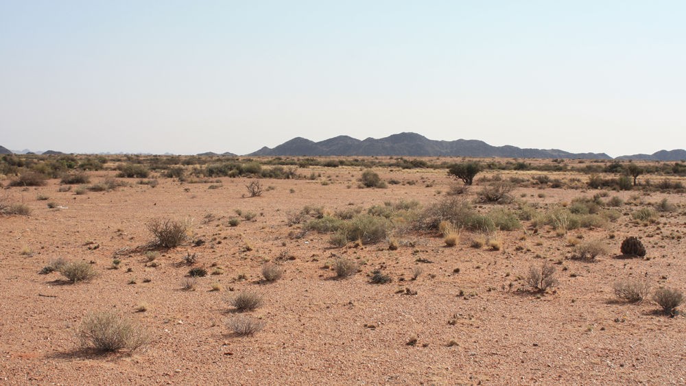
Bushmanland is an arid area south of the Orange River and west of Kenhardt and east of Springbok (Namaqualand) in the Northern Cape, South Africa. It includes the towns of Pofadder and Aggeneys, and places such as Namies and Bosluis Pan. Extensive plains are dotted with inselbergs like the Gamsberg. Bushmanland is an arid area inland from Namaqualand. It is probably the most inhospitable area in South Africa, arid and largely with infertile soil and highly saline groundwater. Its wildlife, however, both fauna and flora, though sparse, are full of interest. Although the veld is too arid to bloom like that of the West Coast of Namaqualand, even when there is some spring rain, what does appear is highly unusual and often hauntingly beautiful. Vaalputs, a nuclear waste repository, has been sited between Bushmanland and Namaqualand, and acts as a ''de facto ''De facto'' ( ; , "in fact") describes practices that exist in reality, whether or not they are officially recognized by ... [...More Info...] [...Related Items...] OR: [Wikipedia] [Google] [Baidu] |
Bushmanland , an area south of the Orange River and west of Kenhardt and east of Springbok (Namaqualand) in the Northern Cape, South Africa
{{place name disambiguation ...
Bushmanland (Boesmanland in Afrikaans) may refer to: * Bushmanland (South West Africa), a bantustan in South West Africa (present-day Namibia) * Bushmanland, Northern Cape Bushmanland is an arid area south of the Orange River and west of Kenhardt and east of Springbok (Namaqualand) in the Northern Cape, South Africa. It includes the towns of Pofadder and Aggeneys, and places such as Namies and Bosluis Pan. Exten ... [...More Info...] [...Related Items...] OR: [Wikipedia] [Google] [Baidu] |
Orange River
The Orange River (from Afrikaans/Dutch: ''Oranjerivier'') is a river in Southern Africa. It is the longest river in South Africa. With a total length of , the Orange River Basin extends from Lesotho into South Africa and Namibia to the north. It rises in the Drakensberg mountains in Lesotho, flowing westwards through South Africa to the Atlantic Ocean. The river forms part of the international borders between South Africa and Lesotho and between South Africa and Namibia, as well as several provincial borders within South Africa. Except for Upington, it does not pass through any major cities. The Orange River plays an important role in the South African economy by providing water for irrigation and hydroelectric power. The river was named the Orange River in honour of the Dutch ruling family, the House of Orange, by the Dutch explorer Robert Jacob Gordon. Other names include simply the word for river, in Khoekhoegowab orthography written as !Garib, which is rendered in Afrikaan ... [...More Info...] [...Related Items...] OR: [Wikipedia] [Google] [Baidu] |
Kenhardt
Kenhardt (founded 1868) is a small town in the Northern Cape province of South Africa. This little town is about 120 km from Upington, the largest town in the area. History On 27 December 1868, special magistrate Maximillian Jackson with a police contingent, was sent to act against the Griquas in the area. The Griqua's anti-colonial resistance had erupted into an open conflict. Jackson arrived in Kenhardt and set up camp under a giant camelthorn tree. This has been for a long time the most remote settlement in the North-Western Cape. With time the town developed from under this tree, becoming a municipality in 1909. The Hartbees River, with its many sweet thorn trees, provides a green belt irrigated by the Rooiberg Dam. Kenhardt is famous for being at the heart of the Dorper sheep-farming area. Geography This region contains very little vegetation, primarily very low shrubs and yellow grass among a rocky desert kind of landscape. If you travel south from Kenhardt towards B ... [...More Info...] [...Related Items...] OR: [Wikipedia] [Google] [Baidu] |
Springbok, Northern Cape
Springbok is the largest town in the Namaqualand area in the Northern Cape province of South Africa. It was called Springbokfontein until 1911, when it was shortened to Springbok. Springbok is located on the N7 road (South Africa), N7 national route (South Africa), national route which connects the Cape with Namibia, and at the western end of the N14 road (South Africa), N14, which connects it with Upington and Pretoria. It is the main town of the Nama Khoi Local Municipality, which also includes a number of surrounding towns such as Okiep and Nababeep. The town lies at an elevation of in a narrow valley between the high granite domes of the ''Klein Koperberge'' (Small Copper Mountains). This name gives away the reason for the early settlement which gradually turned into a major commercial and administrative centre for copper mining operations in the region. While the town initially developed rapidly, this slowed when rich copper deposits were discovered in Okiep. As the main sour ... [...More Info...] [...Related Items...] OR: [Wikipedia] [Google] [Baidu] |
Namaqualand
Namaqualand (khoekhoe: "Nama-kwa" meaning Nama Khoe people's land) is an arid region of Namibia and South Africa, extending along the west coast over and covering a total area of . It is divided by the lower course of the Orange River into two portions – Little Namaqualand to the south and Great Namaqualand to the north. Little Namaqualand is within the Namakwa District Municipality, forming part of Northern Cape Province, South Africa. It is geographically the largest district in the country, spanning over 26,836 km2. A typical municipality is Kamiesberg Local Municipality. The semidesert Succulent Karoo region experiences hot summers, sparse rainfall, and cold winters.Discover South Africa: Your Online Travel Directory. Discover Namakwa. Great Namaqualand in the Karas Region of Namibia, is sparsely populated by the Namaqua, a Khoikhoi people who have traditionally inhabited the Namaqualand region. Tourism The area’s landscape ranges from an unexploited coast ... [...More Info...] [...Related Items...] OR: [Wikipedia] [Google] [Baidu] |
Northern Cape
The Northern Cape is the largest and most sparsely populated province of South Africa. It was created in 1994 when the Cape Province was split up. Its capital is Kimberley. It includes the Kalahari Gemsbok National Park, part of the Kgalagadi Transfrontier Park and an international park shared with Botswana. It also includes the Augrabies Falls and the diamond mining regions in Kimberley and Alexander Bay. The Namaqualand region in the west is famous for its Namaqualand daisies. The southern towns of De Aar and Colesberg found within the Great Karoo are major transport nodes between Johannesburg, Cape Town and Port Elizabeth. Kuruman can be found in the north-east and is known as a mission station. It is also well known for its artesian spring and Eye of Kuruman. The Orange River flows through the province of Northern Cape, forming the borders with the Free State in the southeast and with Namibia to the northwest. The river is also used to irrigate the many vineyards in the ... [...More Info...] [...Related Items...] OR: [Wikipedia] [Google] [Baidu] |
South Africa
South Africa, officially the Republic of South Africa (RSA), is the southernmost country in Africa. It is bounded to the south by of coastline that stretch along the South Atlantic and Indian Oceans; to the north by the neighbouring countries of Namibia, Botswana, and Zimbabwe; and to the east and northeast by Mozambique and Eswatini. It also completely enclaves the country Lesotho. It is the southernmost country on the mainland of the Old World, and the second-most populous country located entirely south of the equator, after Tanzania. South Africa is a biodiversity hotspot, with unique biomes, plant and animal life. With over 60 million people, the country is the world's 24th-most populous nation and covers an area of . South Africa has three capital cities, with the executive, judicial and legislative branches of government based in Pretoria, Bloemfontein, and Cape Town respectively. The largest city is Johannesburg. About 80% of the population are Black South Afri ... [...More Info...] [...Related Items...] OR: [Wikipedia] [Google] [Baidu] |
Aggeneys
Aggeneys is a mining town established in 1976 on a farm of that name, situated between Pofadder and Springbok in the Northern Cape, South Africa. Origin of the name It has been stated that "no-one is quite certain of the origin of the name Aggeneys". Derived from the Nama language, suggested meanings include "Place of Blood", "Place of Red Clay" or "Place of Reeds". One author favours the last of these: the Nama word ‡''a'' means "reed" while !''keis'' means "place". Mining and geological contexts Aggeneys the town, on a farm of that name, was founded to service the Black Mountain Mine, an underground base-metal operation nearby, currently employing over 600 permanent staff. This zinc/lead/copper/silver mine is just to the west of the town. The produce of the mine is transported by truck to the nearest railway line, located to the south-east along a virtually straight gravel (dirt) road. The diversified ore is then railed down to Saldanha Bay where it is exported out in 50 ... [...More Info...] [...Related Items...] OR: [Wikipedia] [Google] [Baidu] |
Inselberg
An inselberg or monadnock () is an isolated rock hill, knob, ridge, or small mountain that rises abruptly from a gently sloping or virtually level surrounding plain. In Southern Africa a similar formation of granite is known as a koppie, an Afrikaans word ("little head") from the Dutch diminutive word ''kopje''. If the inselberg is dome-shaped and formed from granite or gneiss, it can also be called a bornhardt, though not all bornhardts are inselbergs. An inselberg results when a body of rock resistant to erosion, such as granite, occurring within a body of softer rocks, is exposed by differential erosion and lowering of the surrounding landscape. Etymology Inselberg The word ''inselberg'' is a loan word from German, and means "island mountain". The term was coined in 1900 by geologist Wilhelm Bornhardt (1864–1946) to describe the abundance of such features found in eastern Africa. At that time, the term applied only to arid landscape features. However, it has sin ... [...More Info...] [...Related Items...] OR: [Wikipedia] [Google] [Baidu] |
Vaalputs
Vaalputs is the only South African radioactive waste-disposal facility, called the ''Vaalputs Radioactive Waste Disposal Facility'', operated by NECSA. The facility is located about 100 km south-east of Springbok, in the Northern Cape. It covers an area of approximately 10,000 hectare, measuring 16,5 km from east to west and 6,5 km from north to south at its narrowest point. Approximately 1,000 hectare is occupied by sites developed for low- and intermediate-level waste, an interim spent nuclear fuel storage facility, housing, roads, power lines and an airstrip. Vaalputs lies between the Namaqualand in the west and the Bushmanland in the east. During 1978 a programme to select a suitable site for the disposal of nuclear waste was commenced over large parts of South Africa. The programme leader had to keep a variety of socio-economic and geology related parameters in mind. Pioneer investigations indicated that the Northern Cape was the most feasible area. Supplemen ... [...More Info...] [...Related Items...] OR: [Wikipedia] [Google] [Baidu] |


