|
Burgh-by-Sands
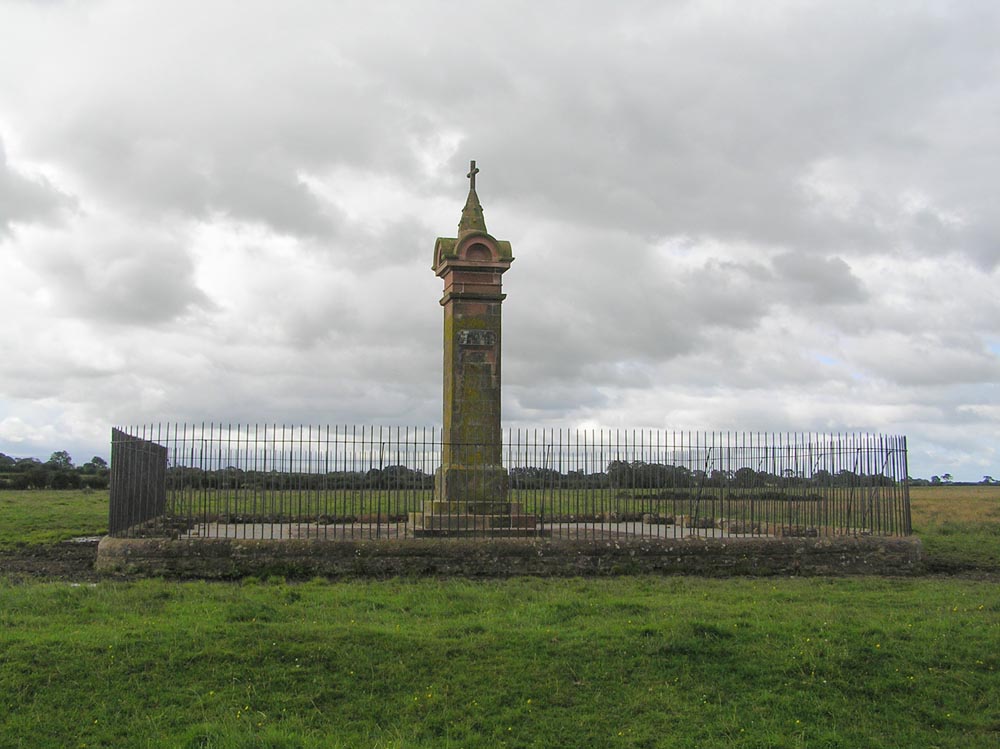
Burgh by Sands () is a village and civil parish in the City of Carlisle district of Cumbria, England, situated near the Solway Firth. The parish includes the village of Burgh by Sands along with Longburgh, Dykesfield, Boustead Hill, Moorhouse and Thurstonfield. It is notable as the site of the first recorded North African (Moorish) military unit in Roman Britain, garrisoning the frontier fort of Aballava on Hadrian's Wall in the 3rd century AD. It is also where Edward I of England died in 1307. According to the 2011 census the parish had a population of 1,176. The village is about seven miles (11 km) west of Carlisle city centre. The village has a primary school, a pub and a post office. It also has a statue of Edward I at some distance to the north. Burgh was on the Carlisle Navigation canal from 1823 to 1853, after which it was served by the Port Carlisle railway, which was built on the bed of the canal, until its closure in 1932. From 1856 to 1964, railway trains operat ... [...More Info...] [...Related Items...] OR: [Wikipedia] [Google] [Baidu] |
Burgh-by-Sands Railway Station
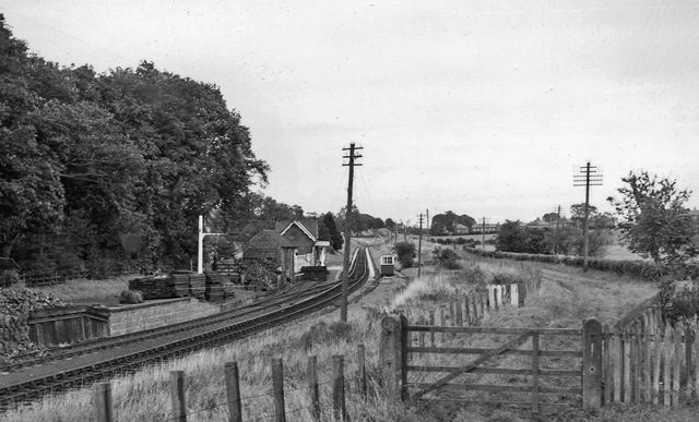
Burgh-by-Sands railway station was originally named Burgh (pronounced "Bruff"). It opened in 1854 on the Port Carlisle Railway branch and later the Silloth branch, serving the village of Burgh in Cumberland - now Cumbria - England. Retrieved : 2012-08-21 The line and station closed on 7 September 1964 as part of the .Cumbria Railways Retrieved : 2012-08-21 In 2014 the station building survived as a private dwelling. History In 1819 a port was constructed at |
Burgh-by-Sands Station 1939604 Ceb64412
Burgh by Sands () is a village and civil parish in the City of Carlisle district of Cumbria, England, situated near the Solway Firth. The parish includes the village of Burgh by Sands along with Longburgh, Dykesfield, Boustead Hill, Moorhouse and Thurstonfield. It is notable as the site of the first recorded North African (Moorish) military unit in Roman Britain, garrisoning the frontier fort of Aballava on Hadrian's Wall in the 3rd century AD. It is also where Edward I of England died in 1307. According to the 2011 census the parish had a population of 1,176. The village is about seven miles (11 km) west of Carlisle city centre. The village has a primary school, a pub and a post office. It also has a statue of Edward I at some distance to the north. Burgh was on the Carlisle Navigation canal from 1823 to 1853, after which it was served by the Port Carlisle railway, which was built on the bed of the canal, until its closure in 1932. From 1856 to 1964, railway trains operat ... [...More Info...] [...Related Items...] OR: [Wikipedia] [Google] [Baidu] |
St Michael's Church, Burgh By Sands
St Michael's Church is in the village of Burgh by Sands, Cumbria, England. It is an active Anglican parish church in the deanery of Carlisle, the archdeaconry of Carlisle, and the diocese of Carlisle. Its benefice is united with those of St Andrew, Aikton, St Mary, Kirkandrews-on-Eden with Beaumont, and St Peter, Kirkbampton. The church is recorded in the National Heritage List for England as a designated Grade I listed building. It is a fortified church standing on the line of Hadrian's Wall, and is unique in having had two fortified towers (one of which has been converted into a vestry). History The church dates probably from the late 12th century, with the north aisle added in about 1200. During the 14th century fortified towers were added to the west and east of the church. While the foundations for the west tower were being dug in 1360, the north arcade collapsed and had to be rebuilt. Later, probably in 1713, the east tower was reduced in ... [...More Info...] [...Related Items...] OR: [Wikipedia] [Google] [Baidu] |
Hadrian's Wall
Hadrian's Wall ( la, Vallum Aelium), also known as the Roman Wall, Picts' Wall, or ''Vallum Hadriani'' in Latin, is a former defensive fortification of the Roman province of Britannia, begun in AD 122 in the reign of the Emperor Hadrian. Running from Wallsend on the River Tyne in the east to Bowness-on-Solway in the west of what is now northern England, it was a stone wall with large ditches in front of it and behind it that crossed the whole width of the island. Soldiers were garrisoned along the line of the wall in large forts, smaller milecastles and intervening turrets. In addition to the wall's defensive military role, its gates may have been customs posts. A significant portion of the wall still stands and can be followed on foot along the adjoining Hadrian's Wall Path. The largest Roman archaeological feature in Britain, it runs a total of in northern England. Regarded as a British cultural icon, Hadrian's Wall is one of Britain's major ancient tourist attract ... [...More Info...] [...Related Items...] OR: [Wikipedia] [Google] [Baidu] |
Feudal Barony Of Burgh By Sands
The feudal barony of Burgh by Sands, originally known as Burgh , (also known as the Honour of Burgh by Sands) (pronounced "Bruff") was a feudal barony with its ''caput'' in Burgh by Sands, Cumberland, England. The barony of Burgh was granted by Ranulf le Meschin, Earl of Chester to his son-in-law Robert d'Estrivers. It passed by marriage of his daughter and heiress Ibria to Ranulf d'Engayne. It later passed by the heiress Ada de Engaine to Simon de Morville. The barony passed by successive heirs female to the families of Multon, Dacre, and Howard. It was purchased by John Lowther, 1st Viscount Lonsdale in 1685. Sources *Sanders, I.J. English Baronies: A Study of their Origin and Descent 1086–1327, Oxford, 1960, pp. 23–4, ''Burgh-by-Sands'' References English feudal baronies Feudal barony A feudal baron is a vassal holding a heritable fief called a ''barony'', comprising a specific portion of land, granted by an overlord in return for allegiance and service. Follo ... [...More Info...] [...Related Items...] OR: [Wikipedia] [Google] [Baidu] |
Moorhouse, Cumbria
Moorhouse is a village on the B5307 road in the civil parish of Burgh by Sands in the Carlisle district, in the English county of Cumbria. It is near the city of Carlisle. In 1870–72 the township had a population of 306. It has a pub called 'The Royal Oak Inn'. See also *Listed buildings in Burgh by Sands Burgh by Sands is a civil parish in the City of Carlisle in Cumbria, England. It contains 55 listed buildings that are recorded in the National Heritage List for England. Of these, one is listed at Grade I, the highest of the three grades, t ... References External links Cumbria County History Trust: Burgh-by-Sands(nb: provisional research only - see Talk page) Villages in Cumbria Burgh by Sands {{Cumbria-geo-stub ... [...More Info...] [...Related Items...] OR: [Wikipedia] [Google] [Baidu] |
Yett
A yett (from the Old English and Scots language word for "gate") is a gate or grille of latticed wrought iron bars used for defensive purposes in castles and tower houses. Unlike a portcullis, which is raised and lowered vertically using mechanical means, yetts are hinged in the manner of a traditional gate or door, and secured by bolts attached to the yett, or by long bars drawn out from the wall or gateway. Geographical distribution Yetts are predominantly found in Scotland – where most towers, particularly the later ones, were equipped with them rather than portcullises – but some iron gates are found in the Border counties of England.Toy, p. 198 While few references to yetts exist outside Scotland, an English report of 1416 on Roxburgh Castle (then in English hands) contained recommendations for the insertion of iron gates. Yetts are not restricted to any one region or district within Scotland, but are widespread throughout. Similar grille constructions, frequently ... [...More Info...] [...Related Items...] OR: [Wikipedia] [Google] [Baidu] |
Fortified Church
A fortified church is a church that is built to serve a defensive role in times of war. Such churches were specially designed to incorporate military features, such as thick walls, battlements, and embrasures. Others, such as the Ávila Cathedral were incorporated into the town wall. Monastic communities, such as Solovki Monastery, are often surrounded by a wall, and some churches, such as St. Arbogast in Muttenz, Switzerland, have an outer wall as well. Churches with additional external defences such as curtain walls and wall towers are often referred to more specifically as fortress churches or ''Kirchenburgen'' (literally "church castles"). Most fortified churches may be found in parts of Europe for example in the Dordogne region of France, fought over by France and England in medieval times, and in Transylvania, during the Ottoman invasions. Fortified churches were also built in places controlled by colonial empires, such as one in the Philippines at the scene of the s ... [...More Info...] [...Related Items...] OR: [Wikipedia] [Google] [Baidu] |
Burgh By Sands Castle
Burgh by Sands Castle was located near the village of Burgh by Sands, Cumbria Cumbria ( ) is a ceremonial and non-metropolitan county in North West England, bordering Scotland. The county and Cumbria County Council, its local government, came into existence in 1974 after the passage of the Local Government Act 1972. Cumb ..., England. The castle was located to the east of the village. A fortified manor house is known in the 12th century. A circular pele tower was constructed in the 13th century. It was the caput of the barony of Burgh by Sands. Originally held by Robert d'Estrivers, it passed by marriage of his daughter and heiress Ibria to Ranulf de Engaine. It later passed by the heiress Ada to Simon de Morville and then Thomas de Multon. The castle was destroyed in 1339 during a raid by a Scottish army and was never rebuilt. No remains are evident above ground. References *Curwen, J.F. Castles and Fortified Towers of Cumberland, Westmorland and Lancashire North of the ... [...More Info...] [...Related Items...] OR: [Wikipedia] [Google] [Baidu] |
Vestry
A vestry was a committee for the local secular and ecclesiastical government for a parish in England, Wales and some English colonies which originally met in the vestry or sacristy of the parish church, and consequently became known colloquially as the "vestry". Overview For many centuries, in the absence of any other authority (which there would be in an incorporated city or town), the vestries were the sole ''de facto'' local government in most of the country, and presided over local, communal fundraising and expenditure until the mid or late 19th century using local established Church chairmanship. They were concerned for the spiritual but also the temporal as well as physical welfare of parishioners and its parish amenities, collecting local rates or taxes and taking responsibility for numerous functions such as the care of the poor, the maintaining of roads, and law enforcement, etc. More punitive matters were dealt with by the manorial court and hundred court, and latter ... [...More Info...] [...Related Items...] OR: [Wikipedia] [Google] [Baidu] |
Westminster Abbey
Westminster Abbey, formally titled the Collegiate Church of Saint Peter at Westminster, is an historic, mainly Gothic church in the City of Westminster, London, England, just to the west of the Palace of Westminster. It is one of the United Kingdom's most notable religious buildings and since Edward the Confessor, a burial site for English and, later, British monarchs. Since the coronation of William the Conqueror in 1066, all coronations of English and British monarchs have occurred in Westminster Abbey. Sixteen royal weddings have occurred at the abbey since 1100. According to a tradition first reported by Sulcard in about 1080, a church was founded at the site (then known as Thorney Island) in the seventh century, at the time of Mellitus, Bishop of London. Construction of the present church began in 1245 on the orders of Henry III. The church was originally part of a Catholic Benedictine abbey, which was dissolved in 1539. It then served as the cathedral of the Dioce ... [...More Info...] [...Related Items...] OR: [Wikipedia] [Google] [Baidu] |
Wards And Electoral Divisions Of The United Kingdom
The wards and electoral divisions in the United Kingdom are electoral districts at sub-national level, represented by one or more councillors. The ward is the primary unit of English electoral geography for civil parishes and borough and district councils, the electoral ward is the unit used by Welsh principal councils, while the electoral division is the unit used by English county councils and some unitary authorities. Each ward/division has an average electorate of about 5,500 people, but ward population counts can vary substantially. As of 2021 there are 8,694 electoral wards/divisions in the UK. England The London boroughs, metropolitan boroughs and non-metropolitan districts (including most unitary authorities) are divided into wards for local elections. However, county council elections (as well as those for several unitary councils which were formerly county councils, such as the Isle of Wight and Shropshire Councils) instead use the term ''electoral division''. In s ... [...More Info...] [...Related Items...] OR: [Wikipedia] [Google] [Baidu] |


