|
Bualli Pass
The Bualli Pass ( sq, Qafa e Buallit, Buffalo Pass) is an 842 metre high mountain pass in Albania. It is part of the National Road 6, which links the Albanian coast to Mat District and the Dibër valley. The west end of the pass is in the watershed of the Mat river and the eastern part is in the watershed of the Drin. Immediately east of the highest point of the pass is the town of Bulqizë. As of 2011, a new road through the pass was being built, the so-called Rruga e Arbërit. Between Bulqizë and the Drin, National Road 6 was expanded into a wider, two-lane highway, a by-pass was built around Bulqizë itself and then work continued further west. The pass itself was crossed by a short tunnel. The west approach to Klos received a new route. Eventually, the Rruga e Arbërit is intended to provide a direct connection between Tirana Tirana ( , ; aln, Tirona) is the capital and largest city of Albania. It is located in the centre of the country, enclosed by mountains and h ... [...More Info...] [...Related Items...] OR: [Wikipedia] [Google] [Baidu] |
Klos (municipality)
Klos ( sq-definite, Klosi) is a town and a municipality in Mat District, northern center Albania. It was formed at the 2015 local government reform by the merger of the former municipalities Gurrë, Klos, Suç and Xibër, that became municipal units. The seat of the municipality is the town Klos. The total population is 16,618 (2011 census), in a total area of 357.72 km2. The population of the former municipality at the 2011 census was 7,873. Klos lies 28.5 kilometers (17¾ mi) 'as the crow flies' from Tirana and 14 kilometers (9 mi) from Burrel. Demographic history Klos (''Kilos'') is recorded in the Ottoman ''defter'' of 1467 as a '' hass-ı mir-liva'' and '' derbendci'' settlement in the vilayet of Mati. The village had a total of eight households represented by the following household heads: ''Kozma Kimiza'', ''Progon Shargjini'', ''Martin Doroza'', ''Gjin Doroza'', ''Dula Cukali'', ''Margjin Prifti'', ''Ilia Kimiza'', and ''Kola Kimiza''. Economy The land is ... [...More Info...] [...Related Items...] OR: [Wikipedia] [Google] [Baidu] |
Martanesh
Martanesh ( sq, Martaneshi) is a geographic and Historical region, ethnographic region within the Dibër County in eastern Albania. Formerly a commune, at the 2015 local government reform it became a subdivision of the municipality Bulqizë. The population at the 2011 census was 1,836.2011 census results The settlement holding the status of town is Krastë, Dibër, Krastë, which was also the center of the commune. The population is largely Bektashi Order, Bektashi with a rather small Catholic minority, and the commune contains the Teqe of Martanesh. History Martanesh is recorded in the Ottoman Empire, Ottoman ''defter'' of 1467 as a ''Hass (Ottoman), hass-ı mir-liva'' settlement in the vilayet of Mati. Although the register's complete survey on the village is missing, the following household heads are at ...[...More Info...] [...Related Items...] OR: [Wikipedia] [Google] [Baidu] |
Krastë, Dibër
Krastë ( sq-definite, Krasta) is a small town in Dibër County, east Albania. With a population of 2142, it is the center and only town of the municipal unit of Martanesh. At the 2015 local government reform it became part of the municipality Bulqizë. Situated on a plateau, at altitude, it is Albania's highest town.Military topographic map of Albania (1:25 000): K-34-89-C-b (BULQIZA) Krastë was founded as a new mining town in 1970, mostly for the exploitation of chromium ore from the Batra mine. Geography and location One of the smallest urban settlements of Albania, Krastë is the center of the former commune of Martanesh, in Dibër County, Dibër county. It lies on a plateau, on the western slope of Kalti mountain , part of Mali i Lopës. It has an altitude of , making it the highest town in Albania. Krastë is situated in a relatively isolated mountainous region and is 20 km far from its nearest city, Bulqizë. Krastë is almost by road from the capital Tirana, despit ... [...More Info...] [...Related Items...] OR: [Wikipedia] [Google] [Baidu] |
Burrel, Albania
Burrel (alternate forms ''Burrel'', ''Mat'') is a town in northern Albania, 91 km from Tirana. At the 2015 local government reform it became a subdivision and the seat of the municipality Mat. It was the seat of the former District of Mat. The population at the 2011 census was 10,862.2011 census results History  The last archaeological researches has explored different trails which demonstrate the population of the area from the paleolithic era. The valley of
 [...More Info...] [...Related Items...] OR: [Wikipedia] [Google] [Baidu] |
Milot, Kurbin
Milot is a town and a former municipality in the Lezhë County of northwestern Albania. At the 2015 local government reform it became a subdivision of the municipality Kurbin. The population at the 2011 census was 8,461.2011 census results The municipal unit of Milot is composed of the town Milot and 14 villages, including Fushë Milot, Mal i Bardhë, Vinjoll, Shkopet, Ferr-Shkopet and Skuraj. The town stands on the southern bank of the . Nearby is the well-known Zogu Bridge named after the leader |
Tirana
Tirana ( , ; aln, Tirona) is the capital and largest city of Albania. It is located in the centre of the country, enclosed by mountains and hills with Dajti rising to the east and a slight valley to the northwest overlooking the Adriatic Sea in the distance. Due to its location at the Plain of Tirana and the close proximity to the Mediterranean Sea, the city is particularly influenced by a Mediterranean seasonal climate. It is among the wettest and sunniest cities in Europe, with 2,544 hours of sun per year. Tirana was founded as a city in 1614 by the Ottoman Albanian general Sylejman Pasha Bargjini and flourished by then around the Old Mosque and the ''türbe''. The area that today corresponds to the city's territory has been continuously inhabited since the Iron Age. It was inhabited by Illyrians, and was most likely the core of the Illyrian Kingdom of the Taulantii, which in Classical Antiquity was centred in the hinterland of Epidamnus. Following the Illyrian Wars it wa ... [...More Info...] [...Related Items...] OR: [Wikipedia] [Google] [Baidu] |
Klos, Dibër
Klos ( sq-definite, Klosi) is a town and a municipality in Mat District, northern center Albania. It was formed at the 2015 local government reform by the merger of the former municipalities Gurrë, Klos, Suç and Xibër, that became municipal units. The seat of the municipality is the town Klos. The total population is 16,618 (2011 census), in a total area of 357.72 km2. The population of the former municipality at the 2011 census was 7,873. Klos lies 28.5 kilometers (17¾ mi) 'as the crow flies' from Tirana and 14 kilometers (9 mi) from Burrel. Demographic history Klos (''Kilos'') is recorded in the Ottoman ''defter'' of 1467 as a '' hass-ı mir-liva'' and '' derbendci'' settlement in the vilayet of Mati. The village had a total of eight households represented by the following household heads: ''Kozma Kimiza'', ''Progon Shargjini'', ''Martin Doroza'', ''Gjin Doroza'', ''Dula Cukali'', ''Margjin Prifti'', ''Ilia Kimiza'', and ''Kola Kimiza''. Economy The land is ... [...More Info...] [...Related Items...] OR: [Wikipedia] [Google] [Baidu] |
Bulqizë
Bulqizë (; sq-definite, Bulqiza) is a Municipalities of Albania, municipality in Dibër County, northeastern Albania. The municipality consists of the administrative units of Fushë-Bulqizë, Gjoricë, Martanesh, Ostren, Shupenzë, Trebisht, Zerqan with Bulqizë constituting its seat. As of the Institute of Statistics (Albania), Institute of Statistics estimate from the 2011 census, there were 8,177 people residing in Bulqizë and 32,210 in Bulqizë Municipality. Demographic history Bulqizë is recorded in the Ottoman Empire, Ottoman ''defter'' of 1467 as a ''Hass (Ottoman), hass-ı mir-liva'' and ''Dervendjis, derbendci'' settlement in the vilayet of ''Gollobordë, Dulgoberda''. Although the register's complete survey on the village is missing, the following household heads are attested: ''Dimitri Bogdani'', ''Kolë Sharqini'', ''Gjin Kimeza'', ''Gjin Kolandi'', ''Nikolla Budi'', ''Martin Bardi'', ''Progon Buljani'', ''Maqe Kimëza'', ''Istvan Nenada'', ''Progon Bogdani'', '' ... [...More Info...] [...Related Items...] OR: [Wikipedia] [Google] [Baidu] |
Albania
Albania ( ; sq, Shqipëri or ), or , also or . officially the Republic of Albania ( sq, Republika e Shqipërisë), is a country in Southeastern Europe. It is located on the Adriatic and Ionian Seas within the Mediterranean Sea and shares land borders with Montenegro to the northwest, Kosovo to the northeast, North Macedonia to the east and Greece to the south. Tirana is its capital and largest city, followed by Durrës, Vlorë, and Shkodër. Albania displays varied climatic, geological, hydrological, and morphological conditions, defined in an area of . It possesses significant diversity with the landscape ranging from the snow-capped mountains in the Albanian Alps as well as the Korab, Skanderbeg, Pindus and Ceraunian Mountains to the hot and sunny coasts of the Albanian Adriatic and Ionian Sea along the Mediterranean Sea. Albania has been inhabited by different civilisations over time, such as the Illyrians, Thracians, Greeks, Romans, Byzantines, Venetians, and Ot ... [...More Info...] [...Related Items...] OR: [Wikipedia] [Google] [Baidu] |
Drin (river)
The Drin (; sq, Drin or ; mk, Дрим, Drim ) is a river in Southern and Southeastern Europe with two distributaries one discharging into the Adriatic Sea and the other one into the Buna River. Its catchment area extends across Albania, Kosovo, Serbia, Greece, Montenegro and North Macedonia. The river and its tributaries form the Gulf of Drin, an ocean basin that encompasses the northern Albanian Adriatic Sea Coast. At long, the Drin is the longest river of Albania of which passes across Albania and the remainder through Kosovo and North Macedonia. It starts at the confluence of its two headwaters, namely the Black Drin and White Drin. It originates in the mountainous northern mountain range, flows westwards through the Albanian Alps and Dukagjin Highlands, and eventually drains into the Adriatic Sea, between Shëngjin and Durrës. Numerous lakes and reservoirs are formed by the river or flow into it such as the Fierza Lake and Koman Lake. Located in the Balkan Pen ... [...More Info...] [...Related Items...] OR: [Wikipedia] [Google] [Baidu] |
Mat (river)
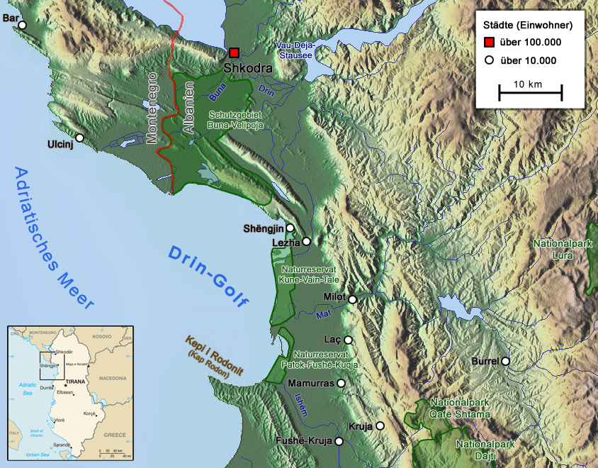
The Mat ( sq-definite, Mati) is a river in north-central Albania. Its overall length is , while its catchment surface is . Its average discharge is . The main tributary is Fan, flowing from the northeast, while the Mat flows from the southwest down to the confluence with Fan and then towards the Adriatic Sea. Etymology The Albanian name ''mat'' originally meant "elevated location", "mountain place". Today's meaning in Albanian, "river bank, river shore", is a consequence of a secondary change through the common use of both the terms ''mal'', "mountain" and ''breg'', "shore", giving the meaning of "elevation". The river was recorded by Roman writer Vibius Sequester (4th or 5th century AD) as ''Mathis'', following a hellenized graphic mode of the term ''mat''. It appeared in written records also as ''Mathia'' in 1380. Overview Mat originates from the confluence of several streams within the karstic mountains in Martanesh, where it forms deep gorges and canyons. Rising in Martane ... [...More Info...] [...Related Items...] OR: [Wikipedia] [Google] [Baidu] |

