|
Brăila
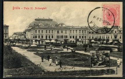
Brăila (, also , ) is a city in Muntenia, eastern Romania, a port on the Danube and the capital of Brăila County. The Sud-Est (development region), ''Sud-Est'' Regional Development Agency is located in Brăila. According to the 2021 Romanian census there were 154,686 people living within the city of Brăila, making it the List of cities and towns in Romania, 11th-most populous city in Romania and the List of cities and towns on the river Danube, 9th-largest of all cities on the river Danube. The current mayor of Brăila is Viorel Marian Dragomir. History Origins Before 14th century, a small village existed in the place of today's Brăila, probably inhabited by fishermen and small merchants.Rădvan, p.248 The village fell to the Mongols during the 1241 Mongol invasion of Europe and it was under direct control of the rulers of Curtea de Argeș, Argeș in mid-14th century. A settlement called ''Drinago'' was found in several 14th century Catalan and Castillian portolan charts ... [...More Info...] [...Related Items...] OR: [Wikipedia] [Google] [Baidu] |
Brăila County
Brăila County () is a county (județ) of Romania, in Muntenia, with the capital city at Brăila. Demographics At the 2021 Romanian census, Brăila County had a population of 281,452 (172,533 people in urban areas and 108,919 people in rural areas.) and the population density was . * Romanians – 98% * Romani people, Romani, Russians, Lipovans, Aromanians, and Minorities of Romania, others - 2% Geography This county has a total area of . All the county lies on a flat plane: the Bărăgan Plain, one of the best areas for growing cereals in Romania. On the east side there is the Danube, which forms an island – the Great Brăila Island –surrounded by the Măcin channel, Cremenea channel, and Vâlciu channel. On the northern side there is the Siret (river), Siret River and on the north-western side there is the Buzău (river), Buzău River. Neighbours * Tulcea County in the east. * Buzău County in the west. * Galați County and Vrancea County in the north. * Ialo ... [...More Info...] [...Related Items...] OR: [Wikipedia] [Google] [Baidu] |
Mayor Of Brăila
The mayor of Brăila, officially the Mayor of the Municipality of Brăila (), is the head of the Brăila City Hall in Brăila, Romania. The current mayor of Brăila is PSD member , who was elected in the 2020 Romanian local elections Local elections were held in Romania on 27 September 2020. Initially planned for June 2020, the emergence of the COVID-19 pandemic led the Government of Romania to postpone the elections to a date no later than 31 December 2020, and extending al ... with over 50% of the votes. This is his second term, as he already was the mayor of the city from 2016 to 2020. References External links * {{Romania-poli-stub ... [...More Info...] [...Related Items...] OR: [Wikipedia] [Google] [Baidu] |
List Of Cities And Towns In Romania
This is a list of cities and towns in Romania, ordered by population (largest to smallest) according to the Demographic history of Romania, 2002, 2011 and 2021 censuses. For the major cities, average elevation is also given. Cities in bold are county capitals. The list includes major cities with the status of ''municipiu'' (103 in total), as well as cities and towns with the status of ''oraș'' (216 in total). Romania has 319 cities and towns: one city with over 1 million inhabitants, 17 other cities with more than 100,000 inhabitants, 153 cities with a population between 10,000 and 100,000 inhabitants, 110 towns between 5,000 and 10,000 inhabitants, and 38 towns with less than 5,000 inhabitants. Complete list See also *Metropolitan areas in Romania *List of cities in Europe *List of city listings by country References {{Authority control Populated places in Romania, * Cities in Romania Towns in Romania Lists of cities in Europe, Romania 2 Lists of cities ... [...More Info...] [...Related Items...] OR: [Wikipedia] [Google] [Baidu] |
Maria Filotti Theatre
The Maria Filotti is a theatre in Brăila, Romania. History The theatre was built in 1896 as "Teatrul Rally". In 1919, it was renamed "Teatrul Comunal" ("The Communal Theatre"), in 1949, "Teatrul del Stat Brăila – Galați Galați ( , , ; also known by other #Etymology and names, alternative names) is the capital city of Galați County in the historical region of Western Moldavia, in eastern Romania. Galați is a port town on the river Danube. and the sixth-larges ..." ("The State Theater of Brăila – Galați"), and in 1969, it acquired its present name, in honour of the Romanian actress, Maria Filotti (1883–1956). Description The theatre has 369 seats. References External links Official site {{Coord, 45, 16, 18.21, N, 27, 58, 24.37, E, display=title Event venues established in 1896 Maria Filotti Buildings and structures in Brăila 1896 establishments in Romania 19th-century architecture in Romania ... [...More Info...] [...Related Items...] OR: [Wikipedia] [Google] [Baidu] |
Danube
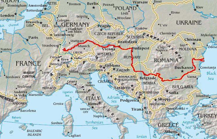
The Danube ( ; see also #Names and etymology, other names) is the List of rivers of Europe#Longest rivers, second-longest river in Europe, after the Volga in Russia. It flows through Central and Southeastern Europe, from the Black Forest south into the Black Sea. A large and historically important river, it was once a frontier of the Roman Empire. In the 21st century, it connects ten European countries, running through their territories or marking a border. Originating in Germany, the Danube flows southeast for , passing through or bordering Austria, Slovakia, Hungary, Croatia, Serbia, Romania, Bulgaria, Moldova, and Ukraine. Among the many List of cities and towns on the river Danube, cities on the river are four national capitals: Vienna, Bratislava, Budapest, and Belgrade. Its drainage basin amounts to and extends into nine more countries. The Danube's longest headstream, the Breg (river), Breg, rises in Furtwangen im Schwarzwald, while the river carries its name from its ... [...More Info...] [...Related Items...] OR: [Wikipedia] [Google] [Baidu] |
Wallachia
Wallachia or Walachia (; ; : , : ) is a historical and geographical region of modern-day Romania. It is situated north of the Lower Danube and south of the Southern Carpathians. Wallachia was traditionally divided into two sections, Muntenia (Greater Wallachia) and Oltenia (Lesser Wallachia). Dobruja could sometimes be considered a third section due to its proximity and brief rule over it. Wallachia as a whole is sometimes referred to as Muntenia through identification with the larger of the two traditional sections. Wallachia was founded as a principality in the early 14th century by Basarab I after a rebellion against Charles I of Hungary, although the first mention of the territory of Wallachia west of the river Olt dates to a charter given to the voivode Seneslau in 1246 by Béla IV of Hungary. In 1417, Wallachia was forced to accept the suzerainty of the Ottoman Empire; this lasted until the 19th century. In 1859, Wallachia united with Moldavia to form the Un ... [...More Info...] [...Related Items...] OR: [Wikipedia] [Google] [Baidu] |
Sud-Est (development Region)
Sud-Est (English ''South East'') is a development region in Romania. As with other development regions, it does not have any administrative powers, its main function being to co-ordinate regional development projects and manage funds from the European Union. Counties The region covers the Southeast part of the country, and it includes the old historical regions of Dobrudja, southern Moldavia, and northeastern Muntenia. The Sud-Est region is made up of the following counties: *Brăila (Muntenia) *Buzău (Muntenia) *Constanța (Dobrudja) *Galați (Moldavia) *Tulcea (Dobrudja) * Vrancea (Moldavia) See also * Development regions of Romania *Nomenclature of Territorial Units for Statistics Nomenclature of Territorial Units for Statistics or NUTS () is a geocode standard for referencing the administrative divisions of countries for statistical purposes. The standard, adopted in 2003, is developed and regulated by the European ... References Development regions of R ... [...More Info...] [...Related Items...] OR: [Wikipedia] [Google] [Baidu] |
List Of Cities And Towns On The River Danube
This is a list of the cities and towns on river Danube. This list does not include parts of cities, Suburb, suburbs, Neighbourhood, neighbourhoods, etc. Any city or town which is located on the Bank (geography), bank of the Danube can be included in this list. The cities and towns on Danube could be sorted by various criteria. The main list of this article sorts the cities and towns on Danube by the current number of inhabitants within the city/town limits. More lists may be added to this article with sorting the cities and towns on Danube by different other criteria. A separate list of villages and other smaller inhabited places on Danube could be added in this article as well. List ‡ First Roman town on the site Bold: capital of the country ''Italic'': capital of the administrative region References {{DEFAULTSORT:Cities and towns on the river Danube Rivers of Europe Lists of cities, Danube ... [...More Info...] [...Related Items...] OR: [Wikipedia] [Google] [Baidu] |
Muntenia
Muntenia (, also known in English as Greater Wallachia) is a historical region of Romania, part of Wallachia (also, sometimes considered Wallachia proper, as ''Muntenia'', ''Țara Românească'', and the rarely used ''Valahia'' are synonyms in Romanian). It is situated between the Danube (south and east), the Carpathian Mountains (the Transylvanian Alps branch) and Moldavia (both north), and the Olt River to the west. The latter river is the border between Muntenia and Oltenia (or ''Lesser Wallachia''). Part of the traditional border between Wallachia/Muntenia and Moldavia was formed by the rivers Milcov and Siret. Geography Muntenia includes București - Ilfov, Sud - Muntenia, and part of the Sud-Est development regions. It consists of nine counties entirely: * Brăila * Buzău * Călărași * Argeș * Dâmbovița * Giurgiu * Ialomița * Ilfov * Prahova And parts of four others: * Teleorman (the entire county with the exception of Islaz) * Vrancea (southern p ... [...More Info...] [...Related Items...] OR: [Wikipedia] [Google] [Baidu] |
Vicina (town)
Vicina was a town on the Danube used as a trading post by the Republic of Genoa, being part of the Genoese trade empire between the 13th and 14th century. At one time, it was the most flourishing port of the maritime Danube, but its importance declined with the development of other ports such as Kilia and Brăila. Although many locations have been proposed by both historians and archeologists as the remains of Vicina, it is still unknown where this town was located. Early history The earliest reference to Vicina (Greek Βιτζίνα, ''Bitzina'') is found in the '' Alexiad'', written in 1148 by Anna Comnena, which described events from late 11th century. She mentions that it was ruled by two Pecheneg chieftains, Sesthlav and Satzas. Soon, trade flourished and Vicina was named a rich town by an Arab traveler. In the 12th century, the Arab geographer al-Idrīsī called the town ''Disina''. Trade The Mongol conquests led to a period of peace and stability (the so-called '' ... [...More Info...] [...Related Items...] OR: [Wikipedia] [Google] [Baidu] |
Johann Schiltberger
Johann (Hans) Schiltberger (1380) was a German traveller and writer. He was born of a noble family, probably at Hollern near Lohhof halfway between Munich and Freising. Travels Schiltberger joined the suite of Lienhart Richartinger in 1394, and he then went to fight under Sigismund, King of Hungary (afterwards emperor), against the Ottoman Empire on the Hungarian frontier. At the Battle of Nicopolis on 28 September 1396, he was wounded and taken prisoner; when Schiltberger had recovered the use of his feet, Sultan Bayezid I (Yıldırım) took him into his service as a runner (1396–1402). He was factually a military slave for over twenty years. During this time of enslavement he seems to have accompanied Ottoman troops to certain parts of Asia Minor and to Egypt. On Bayezid's overthrow at the Battle of Ankara (20 July 1402), Schiltberger passed into the service of Bayezid's conqueror Timur: he now appears to have followed Timur to Samarkand, Armenia and Georgia.Johann Sc ... [...More Info...] [...Related Items...] OR: [Wikipedia] [Google] [Baidu] |


