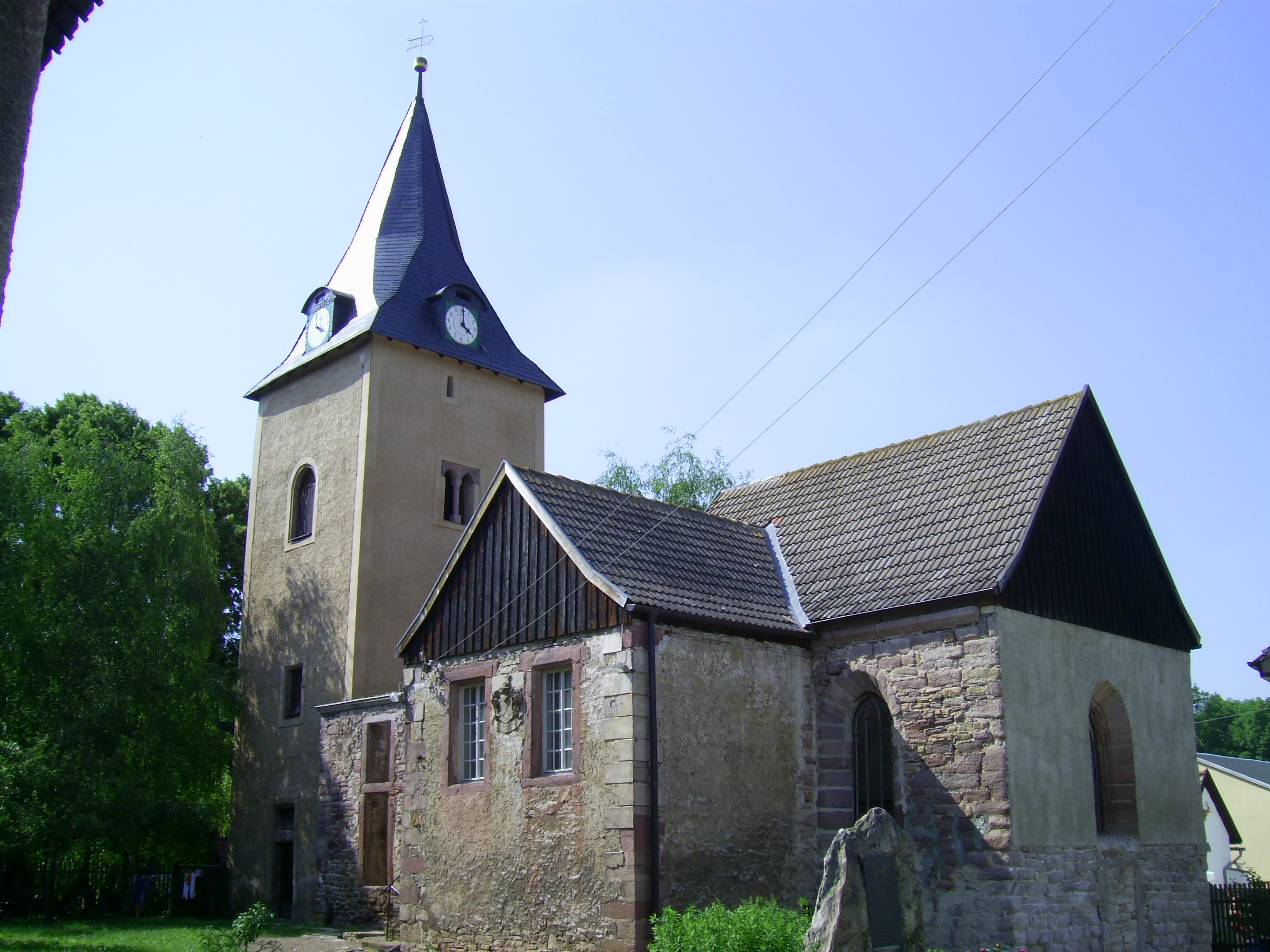
Brücken-Hackpfüffel
   HOME
*


Brücken-Hackpfüffel
Brücken-Hackpfüffel is a municipality in the Mansfeld-Südharz district, Saxony-Anhalt, Germany. It was formed on 1 January 2009 by the merger of the former municipalities Brücken and Hackpfüffel. Geography The municipality lies north-east of the Kyffhäuser mountain in the Goldene Aue. Sangerhausen, the capital of Mansfeld-Südharz county is only 8 kilometers from the village of Brücken. The area of Brücken-Hackpfüffel stretches from the Unstrut tributary Helme in the north to the border with Thüringia Thuringia (; german: Thüringen ), officially the Free State of Thuringia ( ), is a state of central Germany, covering , the sixth smallest of the sixteen German states. It has a population of about 2.1 million. Erfurt is the capital and larg ... in the south. Historical population Figures prior to 2009 are a sum of the two separate municipalities of Brücken and Hackpfüffel. *Census Data as of 31 December, except for census years. References Mansfeld- ...
[...More Info...]      
[...Related Items...]     OR:     [Wikipedia]   [Google]   [Baidu]  


picture info

Hackpfüffel
Hackpfüffel is a village and a former municipality in the Mansfeld-Südharz district, in Saxony-Anhalt, Germany. Since 1 January 2009, it is part of the municipality Brücken-Hackpfüffel. Geographical Location Hackpfüffel lies in the so-called Rieth in the lower Helme valley, north-east of the Kyffhäuser. The road between Kelbra and Artern Artern is a town in the Kyffhäuserkreis district, Thuringia, Germany. The former municipalities Heygendorf and Voigtstedt were merged into Artern in January 2019. Geography Artern is situated at the confluence of the rivers Unstrut and Helme, ... goes through the town. History Origins In the year 899, the place was first mentioned as ''Bablide'' (German: Place on the swamp) erwähnt. In the year 1131, it was documented as ''Pefelde''. At the beginning of the 13th Century, the place was in the possession of the Imperial Knight Thomas von Wallhausen. After 1231 Hackpfüffel was known as imperial estate ''Peflede''. Variant spell ...
[...More Info...]      
[...Related Items...]     OR:     [Wikipedia]   [Google]   [Baidu]  


Brücken, Saxony-Anhalt
Brücken is a village and a former municipality in the Mansfeld-Südharz district, in Saxony-Anhalt, Germany. Since 1 January 2009, it is part of the municipality Brücken-Hackpfüffel. History Brücken was referenced in a document at Hersfeld Abbey as ''Trizzebruccun'' at the start of the 9th Century. The settlement of Brücken was awarded a town charter in 1518 by Kaiser Maximilian I, however this was withdrawn in the following centuries. Brücken was occupied by US troops in April 1945, which were relieved by the Red Army in July of the same year. Famous Residents Johann Heinrich Gottlob von Justi Johann Heinrich Gottlob von Justi (28 December 1717Jürgen Georg Backhaus, ''The Beginnings of Political Economy: Johann Heinrich Gottlob Von Justi'' (Springer, 2008: ), p. 20 The Political Economy of J.H.G. Justi by Ulrich Adam, p. 24/ref>21 July ... (1717 - 1771), political economist, was born in the town Former municipalities in Saxony-Anhalt Mansfeld-Südharz {{M ...
[...More Info...]      
[...Related Items...]     OR:     [Wikipedia]   [Google]   [Baidu]  


Goldene Aue, Saxony-Anhalt
Goldene Aue is a ''Verbandsgemeinde'' ("collective municipality") in the Mansfeld-Südharz district, in Saxony-Anhalt, Germany. Before 1 January 2010, it was a ''Verwaltungsgemeinschaft''. It is situated south and west of Sangerhausen. It is named after the Goldene Aue valley. The seat of the ''Verbandsgemeinde'' is in Kelbra. The ''Verbandsgemeinde'' Goldene Aue consists of the following municipalities: # Berga # Brücken-Hackpfüffel # Edersleben # Kelbra Kelbra () is a town the Mansfeld-Südharz district, in Saxony-Anhalt, Germany. It is situated north of the Kyffhäuser mountains, approx. 20 km west of Sangerhausen, and 20 km east of Nordhausen. Kelbra is part of the ''Verbandsgemeind ... # Wallhausen References Verbandsgemeinden in Saxony-Anhalt {{MansfeldSüdharz-geo-stub ...
[...More Info...]      
[...Related Items...]     OR:     [Wikipedia]   [Google]   [Baidu]  


Mansfeld-Südharz
Mansfeld-Südharz is a district in Saxony-Anhalt, Germany. Its area is . History The district was established by merging the former districts of Sangerhausen and Mansfelder Land as part of the reform of 2007. In the German parliament, the Bundestag The Bundestag (, "Federal Diet") is the German federal parliament. It is the only federal representative body that is directly elected by the German people. It is comparable to the United States House of Representatives or the House of Commons ..., the area forms part of the Mansfeld electoral district. Towns and municipalities The district Mansfeld-Südharz consists of the following subdivisions: References {{MansfeldSüdharz-geo-stub ...
[...More Info...]      
[...Related Items...]     OR:     [Wikipedia]   [Google]   [Baidu]  


Statistisches Landesamt Sachsen-Anhalt
The statistical offices of the German states (German: ''Statistische Landesämter'') carry out the task of collecting official statistics in Germany together and in cooperation with the Federal Statistical Office. The implementation of statistics according to Article 83 of the constitution is executed at state level. The federal government has, under Article 73 (1) 11. of the constitution, the exclusive legislation for the "statistics for federal purposes." There are 14 statistical offices for the 16 states: See also * Federal Statistical Office of Germany References {{Reflist Germany Statistical offices Germany Germany,, officially the Federal Republic of Germany, is a country in Central Europe. It is the second most populous country in Europe after Russia, and the most populous member state of the European Union. Germany is situated betwe ...
...
[...More Info...]      
[...Related Items...]     OR:     [Wikipedia]   [Google]   [Baidu]  


picture info

Saxony-Anhalt
Saxony-Anhalt (german: Sachsen-Anhalt ; nds, Sassen-Anholt) is a state of Germany, bordering the states of Brandenburg, Saxony, Thuringia and Lower Saxony. It covers an area of and has a population of 2.18 million inhabitants, making it the 8th-largest state in Germany by area and the 11th-largest by population. Its capital is Magdeburg and its largest city is Halle (Saale). The state of Saxony-Anhalt was formed in July 1945 after World War II, when the Soviet army administration in Allied-occupied Germany formed it from the former Prussian Province of Saxony and the Free State of Anhalt. Saxony-Anhalt became part of the German Democratic Republic in 1949, but was dissolved in 1952 during administrative reforms and its territory divided into the districts of Halle and Magdeburg. Following German reunification the state of Saxony-Anhalt was re-established in 1990 and became one of the new states of the Federal Republic of Germany. Saxony-Anhalt is renowned for its ri ...
[...More Info...]      
[...Related Items...]     OR:     [Wikipedia]   [Google]   [Baidu]  


Germany
Germany,, officially the Federal Republic of Germany, is a country in Central Europe. It is the second most populous country in Europe after Russia, and the most populous member state of the European Union. Germany is situated between the Baltic and North seas to the north, and the Alps to the south; it covers an area of , with a population of almost 84 million within its 16 constituent states. Germany borders Denmark to the north, Poland and the Czech Republic to the east, Austria and Switzerland to the south, and France, Luxembourg, Belgium, and the Netherlands to the west. The nation's capital and most populous city is Berlin and its financial centre is Frankfurt; the largest urban area is the Ruhr. Various Germanic tribes have inhabited the northern parts of modern Germany since classical antiquity. A region named Germania was documented before AD 100. In 962, the Kingdom of Germany formed the bulk of the Holy Roman Empire. During the 16th ce ...
[...More Info...]      
[...Related Items...]     OR:     [Wikipedia]   [Google]   [Baidu]  


picture info

Statistisches Bundesamt
The Federal Statistical Office (german: Statistisches Bundesamt, shortened ''Destatis'') is a federal authority of Germany. It reports to the Federal Ministry of the Interior. The Office is responsible for collecting, processing, presenting and analysing statistical information concerning the topics economy, society and environment. The purpose is providing objective, independent and highly qualitative statistical information for the whole public. About 2300 staff members are employed in the departments in Wiesbaden, Bonn and Berlin. The department in Wiesbaden is the main office and runs the largest library specialised in statistical literature in Germany. It is also the Office of the President who is also by tradition, but not by virtue of the office, the Federal Returning Officer. In this position, they are the supervisor of the elections of the German Parliament ("Bundestag") and of the European Parliament. The Berlin Information Point is the service centre of the Federal O ...
[...More Info...]      
[...Related Items...]     OR:     [Wikipedia]   [Google]   [Baidu]  


picture info

Kyffhäuser
The Kyffhäuser (,''Duden - Das Aussprachewörterbuch, 7. Auflage (German)'', Dudenverlag, sometimes also referred to as ''Kyffhäusergebirge'', is a hill range in Central Germany, shared by Thuringia and Saxony-Anhalt, southeast of the Harz mountains. It reaches its highest point at the Kulpenberg with an elevation of . The range is the site of medieval Kyffhausen Castle (''Reichsburg Kyffhausen'') and the 19th century Kyffhäuser Monument; it has significance in German traditional mythology as the legendary resting place of Emperor Frederick Barbarossa. Etymology The origin of the name has not been conclusively established. ''Kyffhäuser'' (formerly also ''Kiffhäuser'') probably stems from the Low German word ''cuf'', meaning "head" or "peak", and ''huse'', "house". Other explanations refer to ''kiff'', "quarrel" and the historic castles at the site. Geography The Kyffhäuser is a small ''Mittelgebirge'' located in the Kyffhäuserkreis district of Thuringia and the Mansfeld ...
[...More Info...]      
[...Related Items...]     OR:     [Wikipedia]   [Google]   [Baidu]  


Goldene Aue
The Goldene Aue (German: "golden lowland", also " ... bottom" or " ... meadow" / " ... pasture", with "Au referring to a low-lying area, often a wetland) is a valley in eastern Germany, in the states Thuringia and Saxony-Anhalt. It is situated between the towns Nordhausen in the west, and Sangerhausen in the east. It is bordered by the mountain ranges Harz in the north, and Windleite and Kyffhäuser in the south. The river Helme flows through the Goldene Aue. Goldene Aue is also the name of two ''Verwaltungsgemeinschaften'' ("collective municipalities") in the valley: *Goldene Aue, Saxony-Anhalt *Goldene Aue, Thuringia Goldene Aue is a former ''Verwaltungsgemeinschaft'' ("collective municipality") in the district of Nordhausen, in Thuringia, Germany. The seat of the ''Verwaltungsgemeinschaft'' was in Heringen. It was disbanded on 1 December 2010. The ''Verwalt ... {{Authority control Regions of Thuringia Nordhausen, Thuringia ...
[...More Info...]      
[...Related Items...]     OR:     [Wikipedia]   [Google]   [Baidu]  


picture info

Sangerhausen
Sangerhausen () is a town in Saxony-Anhalt, central Germany, capital of the district of Mansfeld-Südharz. It is situated southeast of the Harz, approx. east of Nordhausen, and west of Halle (Saale). About 26,000 people live in Sangerhausen (2020). History Sangerhausen is one of the oldest towns in the historical region of Saxony-Anhalt, being first mentioned in a document created between 780 and 802 in Fulda Abbey. Sangerhausen is mentioned as the tithable place ''Sangerhus'' in Friesenfeld in the Hersfeld Tithe Register, created between 881 and 899. It is mentioned in a document of 991 as appertaining to the estates of the emperor, as part of Memleben Abbey. By marriage it passed to the landgrave of Thuringia, and after 1056 it formed for a while an independent country. Having been again part of Thuringia, it fell in 1249 to Meissen, and in 1291 to Brandenburg. In 1372 it passed to the Electorate of Saxony and formed a portion of that territory until 1815, when it became ...
[...More Info...]      
[...Related Items...]     OR:     [Wikipedia]   [Google]   [Baidu]  


Unstrut
The Unstrut () is a river in Germany and a left tributary of the Saale. The Unstrut originates in northern Thuringia near Dingelstädt (west of Kefferhausen in the Eichsfeld area) and its catchment area is the whole of the Thuringian Basin. It breaks out of the basin through the Thuringian Gate west of Heldrungen and, in its lower reaches, flows through Saxony-Anhalt before emptying into the Saale near Naumburg. The total length of the Unstrut is . Towns along the Unstrut include Mühlhausen, Sömmerda, Bad Frankenhausen, Artern, Roßleben, and Freyburg, Germany, Freyburg. The main tributaries of the Unstrut are the Gera (river), Gera, Wipper (Unstrut), Wipper, Helme, and Lossa (Unstrut), Lossa. The countryside around the Saale and Unstrut rivers forms the wine-growing region of Saale-Unstrut. The well-known brand of sparkling wine, ''Rotkäppchen'' ("Little Red Riding Hood") is produced in the cellars of Freyburg. Name Old High German ''Strödu'' means 'boggy thicket' and '' ...
[...More Info...]      
[...Related Items...]     OR:     [Wikipedia]   [Google]   [Baidu]