|
Brantford Township, Ontario
The County of Brant (2021 population 39,474) is a single-tier municipality in the Canadian province of Ontario. Although it retains the word "county" in its name, the municipality is a single-tier municipal government and has no upper tier. The County of Brant has service offices in Burford, Paris, Oakland, Onondaga and St. George. The largest population centre (2021 population 14,956) is Paris. The County of Brant is a predominantly rural municipality in Southern Ontario. The County is bordered by the township of North Dumfries in the Regional Municipality of Waterloo; the City of Hamilton; Haldimand County; Norfolk County; and the townships of Blandford-Blenheim and Norwich in Oxford County. The County abuts the provincially-mandated Greenbelt. Although the city of Brantford is surrounded by the County, it is a fully independent city with its own municipal government. The Brant census division, which includes Brantford and the Six Nations and New Credit reserves along with ... [...More Info...] [...Related Items...] OR: [Wikipedia] [Google] [Baidu] |
List Of Cities In Ontario
A city is a subtype of List of municipalities in Ontario, municipalities in the Provinces and territories of Canada, Canadian province of Ontario. A city can have the municipal status of either a List of municipalities in Ontario#Unitary authority ("Single-tier") configuration, single-tier or List of municipalities in Ontario#Two-level ("Upper- and lower-tier") configuration, lower-tier municipality. Prior to 2003, Ontario had minimum population thresholds of 15,000 and 25,000 for city status. Minimum population thresholds are no longer necessary for a municipality to brand itself as a city. Ontario has 52 cities, which together had Canada 2016 Census, in 2016 a cumulative population of 9,900,179 and average population of 190,388. The most and least populous are Toronto and Dryden, Ontario, Dryden, with 2,731,571 and 7,749 residents, respectively. Ontario's newest city is Richmond Hill, Ontario, Richmond Hill, whose council voted to change from a town to a city on ... [...More Info...] [...Related Items...] OR: [Wikipedia] [Google] [Baidu] |
Former Counties Of Ontario
The Canadian province of Ontario has several historic counties, which are past census divisions that no longer exist today. Most historic counties either merged with other counties, or became regional municipalities or single-tier municipalities. Although counties had existed prior to 1849, after 1849 they replaced the district systems in administering local government and courts in Ontario. The county system is used in southern, southwestern and eastern sections of the province of Ontario. There are no counties in Northern Ontario due to sparse population and a long-standing boundary dispute with the Northwest Territories (that was not resolved until 1912). Counties * Addington County (1792–1864) merged with Lennox County to form Lennox and Addington County *Brant County (established 1852) split into the single-tier 'county' of Brant and the city of Brantford * Carleton County (1800–1969) became the Regional Municipality of Ottawa-Carleton, now the City of Ottawa, a single- ... [...More Info...] [...Related Items...] OR: [Wikipedia] [Google] [Baidu] |
Census Divisions Of Canada
The census geographic units of Canada are the census subdivisions defined and used by Canada's federal government statistics bureau Statistics Canada to conduct the country's quinquennial census. These areas exist solely for the purposes of statistical analysis and presentation; they have no government of their own. They exist on four levels: the top-level (first-level) divisions are Canada's provinces and territories; these are divided into second-level census divisions, which in turn are divided into third-level census subdivisions (often corresponding to municipalities) and fourth-level dissemination areas. In some provinces, census divisions correspond to the province's second-level administrative divisions such as a county or another similar unit of political organization. In the prairie provinces, census divisions do not correspond to the province's administrative divisions, but rather group multiple administrative divisions together. In Newfoundland and Labrador, the bou ... [...More Info...] [...Related Items...] OR: [Wikipedia] [Google] [Baidu] |
Brantford
Brantford ( 2021 population: 104,688) is a city in Ontario, Canada, founded on the Grand River in Southwestern Ontario. It is surrounded by Brant County, but is politically separate with a municipal government of its own that is fully independent of the county's municipal government. Brantford is situated on the Haldimand Tract, traditional territory of the Neutral, Mississauga, and Haudenosaunee peoples. The city is named after Joseph Brant, an important Mohawk leader, soldier, farmer and slave owner. Brant was an important Loyalist leader during the American Revolutionary War and later, after the Haudenosaunee moved to the Brantford area in Upper Canada. Many of his descendants, and other First Nations people, live on the nearby Six Nations of the Grand River reserve south of Brantford; it is the most populous reserve in Canada. Brantford is known as the "Telephone City" as the city's famous resident, Alexander Graham Bell, invented the first telephone at his father's ... [...More Info...] [...Related Items...] OR: [Wikipedia] [Google] [Baidu] |
Greenbelt (Golden Horseshoe)
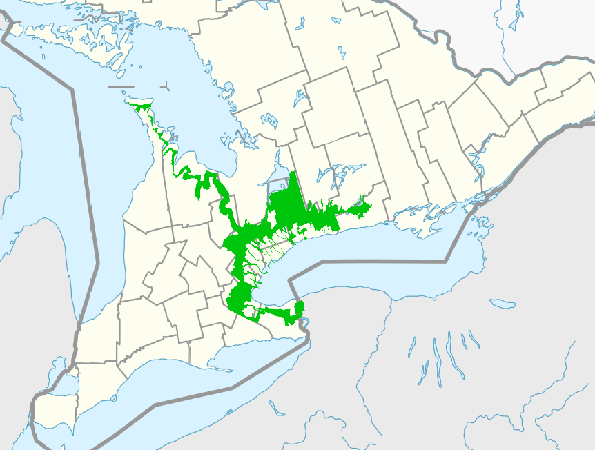
The Greenbelt is a protected area of green space, farmland, forests, wetlands, and watersheds, located in Southern Ontario, Canada. It surrounds a significant portion of the Golden Horseshoe. Created by legislation passed by the Government of Ontario in 2005, the Greenbelt is considered a prevention of urban development and sprawl on environmentally sensitive land in the province. According to the Greenbelt Foundation, the Greenbelt includes of land. That includes of protected wetlands, grasslands, and forests. History The Greenbelt was established around the Golden Horseshoe, one of the fastest growing urban areas in North America. The population in the region increased from 6.5 to 7.7 million between 1991 and 2001. The population increase put urban development pressure on areas surrounding Greater Toronto and Hamilton. Between 1996 and 2001, the amount of farmland decreased by 7% in the GTA, and by 6% in Hamilton. The Golden Horseshoe's population is projected to increas ... [...More Info...] [...Related Items...] OR: [Wikipedia] [Google] [Baidu] |
|


