|
Bramhope Tunnel
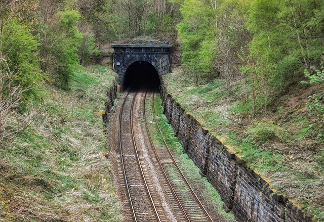
Bramhope Tunnel is on the Harrogate Line between Horsforth station and the Arthington Viaduct in West Yorkshire, England. Services through the railway tunnel are operated mainly by Northern. The tunnel was constructed during 1845–1849 by the Leeds and Thirsk Railway. It is notable for its length and its Grade II listed, crenellated north portal. The deaths of 24 men who were killed during its construction are commemorated in Otley churchyard by a monument that is a replica of the tunnel's north portal. Thomas Grainger was the engineer for the line and James Bray the contractor. Two sighting towers were erected and 20 shafts sunk along the tunnel's line. Men excavated rock from the shaft faces until the shafts were connected and the tunnel was completed in 1848. Thousands of navvies lived locally in temporary bothies with their families, and worked in dangerous and wet conditions to facilitate the grand opening in 1849. History In the mid-1840s Railway Mania was taki ... [...More Info...] [...Related Items...] OR: [Wikipedia] [Google] [Baidu] |
Bothy
A bothy is a basic shelter, usually left unlocked and available for anyone to use free of charge. It was also a term for basic accommodation, usually for gardeners or other workers on an estate. Bothies are found in remote mountainous areas of Scotland, Northern England, Ulster and Wales. They are particularly common in the Scottish Highlands, but related buildings can be found around the world (for example, in the Nordic countries there are wilderness huts). A bothy was also a semi-legal drinking den in the Isle of Lewis. These, such as ''Bothan Eòrapaidh'', were used until recent years as gathering points for local men and were often situated in an old hut or caravan. In Scots law, bothies are defined in law as: a building of no more than two storeys which— (a)does not have any form of— (i)mains electricity, (ii)piped fuel supply, and (iii)piped mains water supply, (b)is 100 metres or more from the nearest public road (within the meaning of section 151 of the Roads (S ... [...More Info...] [...Related Items...] OR: [Wikipedia] [Google] [Baidu] |
Reservoir
A reservoir (; from French ''réservoir'' ) is an enlarged lake behind a dam. Such a dam may be either artificial, built to store fresh water or it may be a natural formation. Reservoirs can be created in a number of ways, including controlling a watercourse that drains an existing body of water, interrupting a watercourse to form an embayment within it, through excavation, or building any number of retaining walls or levees. In other contexts, "reservoirs" may refer to storage spaces for various fluids; they may hold liquids or gasses, including hydrocarbons. ''Tank reservoirs'' store these in ground-level, elevated, or buried tanks. Tank reservoirs for water are also called cisterns. Most underground reservoirs are used to store liquids, principally either water or petroleum. Types Dammed valleys Dammed reservoirs are artificial lakes created and controlled by a dam A dam is a barrier that stops or restricts the flow of surface water or underground streams ... [...More Info...] [...Related Items...] OR: [Wikipedia] [Google] [Baidu] |
Water Supply
Water supply is the provision of water by public utilities, commercial organisations, community endeavors or by individuals, usually via a system of pumps and pipes. Public water supply systems are crucial to properly functioning societies. These systems are what supply drinking water to populations around the globe. Aspects of service quality include continuity of supply, water quality and water pressure. The institutional responsibility for water supply is arranged differently in different countries and regions (urban versus rural). It usually includes issues surrounding policy and regulation, service provision and standardization. The cost of supplying water consists, to a very large extent, of fixed costs (capital costs and personnel costs) and only to a small extent of variable costs that depend on the amount of water consumed (mainly energy and chemicals). Almost all service providers in the world charge tariffs to recover part of their costs. Water supply is a separate ... [...More Info...] [...Related Items...] OR: [Wikipedia] [Google] [Baidu] |
Foundry
A foundry is a factory that produces metal castings. Metals are cast into shapes by melting them into a liquid, pouring the metal into a mold, and removing the mold material after the metal has solidified as it cools. The most common metals processed are aluminum and cast iron. However, other metals, such as bronze, brass, steel, magnesium, and zinc, are also used to produce castings in foundries. In this process, parts of desired shapes and sizes can be formed. Foundries are one of the largest contributors to the manufacturing recycling movement, melting and recasting millions of tons of scrap metal every year to create new durable goods. Moreover, many foundries use sand in their molding process. These foundries often use, recondition, and reuse sand, which is another form of recycling. Process In metalworking, casting involves pouring liquid metal into a mold, which contains a hollow cavity of the desired shape, and then allowing it to cool and solidify. The solidified pa ... [...More Info...] [...Related Items...] OR: [Wikipedia] [Google] [Baidu] |
Bramhope
Bramhope is a village and civil parish in the City of Leeds metropolitan borough, West Yorkshire, England, north of Holt Park and north east of Cookridge. The village is north of Leeds city centre and it is in the LS16 Leeds postcode area. According to the 2001 census the parish had a population of 3,400. The population had increased to 3,533 at the 2011 Census. It is predominantly made up of large, privately owned houses which tend to be above the average value for properties in West Yorkshire. Bramhope sits in the Leeds North West constituency and the Adel & Wharfedale ward of Leeds City Council. Etymology The place-name ''Bramhope'' appears first in the Domesday Book of 1086 as ''Brahop'' and ''Bramhop'', with later medieval spellings including ''Bramhop(a)'' and ''Bramhop(p)e''. The name seems to derive from the Old English words ''brōm'' 'broom' and ''hōp'' 'a small valley, side-valley off a larger valley', here referring to a small valley off Wharfedale, proba ... [...More Info...] [...Related Items...] OR: [Wikipedia] [Google] [Baidu] |
Arthington
Arthington is a small village in Wharfedale, in the City of Leeds metropolitan borough in West Yorkshire, England. It is a civil parish which, according to the 2011 census, had a population of 532 and is in the LS21 postcode district with Otley as its post town. It is in the Otley ward of the City of Leeds, and the Leeds North West parliamentary constituency. Geography The village is a small collection of dwellings and farms along the A659 road (Arthington Lane) running from Pool-in-Wharfedale in the West to Harewood in the East, and south of a section of the River Wharfe. Up Black Hill Road to the south is a working stone quarry. Etymology The name ''Arthington'' is first attested in the Domesday Book as ''Hardinctone'', ''Ardintona'' and ''Ardinton''. The first element of the name comes from the Old English personal name ''Eard'', a nickname form of longer names like ''Eardwulf''; the connecting element ''-ing-'', used to indicate Eard's association with the place; and ... [...More Info...] [...Related Items...] OR: [Wikipedia] [Google] [Baidu] |
Airedale
Airedale is a geographic area in Yorkshire, England, corresponding to the river valley or dale of the River Aire. The valley stretches from the river's origin in Aire Head Springs, Malham which is in the Yorkshire Dales, down past Skipton on to Keighley, Bingley and Shipley through to Leeds and Castleford and on to join the River Ouse at Airmyn. This valley is of great topographic significance as it provides low-altitude passes through the mid Pennines to the west coast known as the Aire Gap. History The upper Aire valley was formed 12,000 years ago by a retreating glacier. A moraine formed in the Cononley area and the lake stretched as far north as Gargrave. Colonisation by man developed later on, especially during the Iron Age. The peoples that occupied the Aire Valley (and much of north eastern England) were called Brigantes by the Romans. Transport improved in the 18th and 19th centuries with the building of the Aire and Calder Navigation and the Leeds and Liverpo ... [...More Info...] [...Related Items...] OR: [Wikipedia] [Google] [Baidu] |
North East England
North East England is one of nine official regions of England at the first level of ITL for statistical purposes. The region has three current administrative levels below the region level in the region; combined authority, unitary authority or metropolitan district and civil parishes. They are also multiple divisions without administrative functions; ceremonial county, emergency services ( fire-and-rescue and police), built-up areas and historic county. The most populous places in the region are Newcastle upon Tyne (city), Middlesbrough, Sunderland (city), Gateshead, Darlington and Hartlepool. Durham also has city status. History The region's historic importance is displayed by Northumberland's ancient castles, the two World Heritage Sites of Durham Cathedral and Durham Castle, and Hadrian's Wall, one of the frontiers of the Roman Empire. In fact, Roman archaeology can be found widely across the region and a special exhibition based around the Roman Fort of Segedunum ... [...More Info...] [...Related Items...] OR: [Wikipedia] [Google] [Baidu] |
Thirsk
Thirsk is a market town and civil parish in the Hambleton district of North Yorkshire, England known for its racecourse; quirky yarnbomber displays, and depiction as local author James Herriot's fictional Darrowby. History Archeological finds indicate there was a settlement in Thirsk around 500–600 BC. The town's name is derived from the Old Norse word ''þresk'' meaning fen or lake. Thirsk is mentioned twice in the 1086 ''Domesday Book'' as ''Tresche'', in the ''Yarlestre'' wapentake, a village with ten households. At the time of the Norman invasion the manor was split between ''Orm'' and ''Thor'', local Anglo-Saxon landowners. Afterwards, it was split between ''Hugh, son of Baldric'' and the Crown. House of Mowbray Most of Thirsk was granted to a Robert from Montbray for whose descendant House of Mowbray the vale of Mowbray is named. By 1145, what is now Old Thirsk, gained a Market charter giving it town and borough status. The remaining land in the parish was sti ... [...More Info...] [...Related Items...] OR: [Wikipedia] [Google] [Baidu] |
Leeds
Leeds () is a city and the administrative centre of the City of Leeds district in West Yorkshire, England. It is built around the River Aire and is in the eastern foothills of the Pennines. It is also the third-largest settlement (by population) in England, after London and Birmingham. The city was a small manorial borough in the 13th century and a market town in the 16th century. It expanded by becoming a major production centre, including of carbonated water where it was invented in the 1760s, and trading centre (mainly with wool) for the 17th and 18th centuries. It was a major mill town during the Industrial Revolution. It was also known for its flax industry, iron foundries, engineering and printing, as well as shopping, with several surviving Victorian era arcades, such as Kirkgate Market. City status was awarded in 1893, a populous urban centre formed in the following century which absorbed surrounding villages and overtook the nearby York population. It is locate ... [...More Info...] [...Related Items...] OR: [Wikipedia] [Google] [Baidu] |
George Hudson
George Hudson (probably 10 March 1800 – 14 December 1871) was an English railway financier and politician who, because he controlled a significant part of the railway network in the 1840s, became known as "The Railway King"—a title conferred on him by Sydney Smith in 1844. Hudson played a significant role in linking London to Edinburgh by rail, carrying out the first major merging of railway companies (the Midland Railway) and developing his home city of York into a major railway junction. He also represented Sunderland in the House of Commons. Hudson's success was built on dubious financial practices and he frequently paid shareholders out of capital rather than money the company had earned. Eventually in 1849, a series of enquiries, launched by the railways he was chairman of, exposed his methods, although many leading the enquiries had benefited from and approved of Hudson's methods when it suited them. Hudson fell a long way, becoming bankrupt, and after losing his Sun ... [...More Info...] [...Related Items...] OR: [Wikipedia] [Google] [Baidu] |


.jpg)


.jpg)
